Cities and Towns in Mesa County, Colorado

Founded on 1883-02-14, Mesa County is one of 64 counties in the state of Colorado. Historically, Mesa County was split from Gunnison County. The city of Grand Junction is the county seat. With FIPS code of 77, Mesa County has a population of 157,335 and area of 3,345.69 square miles (8,665 km²).

List of all cities in Mesa County, CO alphabetically

City/Town Postal Code Area Code
Appleton, CO 81505 970
Clifton, CO 81520 970
Collbran, CO 81624 970
Colorado National Monument, CO 81521 970
De Beque, CO 81630 970
East Orchard Mesa, CO 81526 970
Fruita, CO 81521 970
Fruitvale, CO 81504 970
Gateway, CO 81522 970
Glade Park, CO 81523 970
Grand Junction, CO 81501 970
81502 970
81503 970
81504 970
81505 970
81506 970
81507 970
Loma, CO 81524 970
Mack, CO 81525 970
Mesa, CO 81643 970
Molina, CO 81646 970
New Liberty, CO 81525 970
Palisade, CO 81526 970
Plateau City, CO 81624 970
Whitewater, CO 81527 970

Major Cities and Towns in Mesa County, Colorado

Grand Junction

Area, Population, and Geography

  • Area: 39.6 square miles
  • Population: Approximately 66,000 (2023 estimate)
  • Zip Codes: 81501, 81503, 81504, 81505, 81506, 81507
  • Latitude: 39.0639° N
  • Longitude: 108.5506° W

City Location and History

Grand Junction is the largest city in Mesa County and serves as the county seat. Located at the confluence of the Colorado and Gunnison Rivers, Grand Junction is the major commercial and transportation hub of western Colorado. The city was founded in 1881, originally named Ute after the Native American tribe that inhabited the region. It was later renamed Grand Junction, referring to its location at the junction of the Grand (now Colorado) River and the Gunnison River. The city rapidly developed as a center for agriculture, particularly fruit orchards, thanks to the fertile soil of the Grand Valley. Over time, Grand Junction diversified its economy to include energy production, tourism, and healthcare. Today, the city is known for its beautiful scenery, outdoor recreation, and as the gateway to Colorado’s wine country.

Major Schools and Landmarks

Grand Junction is served by Mesa County Valley School District 51, with Grand Junction High School being one of the primary secondary institutions. The city is also home to Colorado Mesa University, offering a range of undergraduate and graduate programs. Major landmarks include the Colorado National Monument, a stunning expanse of canyons and mesas that offers hiking, rock climbing, and breathtaking views. Downtown Grand Junction is known for its vibrant arts scene, featuring numerous galleries, public art installations, and the Avalon Theatre, a historic venue for films and performances. The Grand Junction Farmers’ Market, held weekly during the summer, showcases local produce, crafts, and live music, reflecting the city’s agricultural heritage. Grand Junction’s blend of educational resources, cultural attractions, and outdoor activities makes it the heart of Mesa County.

Fruita

Area, Population, and Geography

  • Area: 7.3 square miles
  • Population: Approximately 15,000 (2023 estimate)
  • Zip Codes: 81521
  • Latitude: 39.1583° N
  • Longitude: 108.7281° W

City Location and History

Fruita is a small city located about 12 miles northwest of Grand Junction, in the western part of Mesa County. Founded in 1884, Fruita was named for its fertile land, which was ideal for growing fruit orchards. The town quickly became known for its apple, peach, and pear orchards, establishing itself as a major agricultural center in the region. Fruita’s economy has historically been based on agriculture, but in recent years, it has also become a popular destination for outdoor recreation, particularly mountain biking, due to its proximity to the Colorado National Monument and other natural areas. The city’s friendly, small-town atmosphere and scenic surroundings have made it an attractive place for both residents and visitors.

Major Schools and Landmarks

Fruita is served by Mesa County Valley School District 51, with Fruita Monument High School being the main secondary school. The city’s major landmarks include the Colorado National Monument, which offers spectacular views, hiking trails, and opportunities for wildlife observation. Fruita is also known for its world-class mountain biking trails, including the Kokopelli Trail and 18 Road Trails, which attract bikers from across the country. The Dinosaur Journey Museum, part of the Museums of Western Colorado, features exhibits on the region’s rich paleontological history, including dinosaur fossils discovered in the area. Fruita’s annual Mike the Headless Chicken Festival, a quirky event celebrating a local legend, reflects the town’s unique character and sense of community. Fruita’s combination of historical significance, educational resources, and outdoor activities makes it a vibrant community in Mesa County.

Palisade

Area, Population, and Geography

  • Area: 1.1 square miles
  • Population: Approximately 2,700 (2023 estimate)
  • Zip Codes: 81526
  • Latitude: 39.1100° N
  • Longitude: 108.3542° W

City Location and History

Palisade is a small town located east of Grand Junction, nestled along the Colorado River at the foot of the Grand Mesa. Founded in 1904, Palisade is renowned for its peach orchards and vineyards, benefiting from the area’s unique microclimate, which is ideal for growing fruit. The town’s name reflects the “palisades” or cliffs that surround the area. Over the years, Palisade has gained a reputation as Colorado’s wine country, with numerous wineries and vineyards producing award-winning wines. The town has maintained its agricultural heritage while also becoming a popular destination for agritourism, attracting visitors with its farm-to-table experiences, wine tastings, and scenic beauty.

Major Schools and Landmarks

Palisade is served by Mesa County Valley School District 51, with Palisade High School being the primary educational institution. The town’s major landmarks include the many wineries and orchards that dot the landscape, offering tours, tastings, and direct sales of local produce and wines. The Palisade Sunday Market, held weekly during the summer months, showcases local fruits, vegetables, crafts, and live music, making it a community gathering place. The nearby Grand Mesa, the world’s largest flat-topped mountain, offers opportunities for hiking, fishing, and skiing, providing a stunning backdrop to the town. Palisade’s annual Peach Festival celebrates the town’s agricultural heritage with parades, live music, and peach-themed events, drawing visitors from across the region. Palisade’s combination of agricultural heritage, educational resources, and scenic beauty makes it a cherished community in Mesa County.

Collbran

Area, Population, and Geography

  • Area: 0.3 square miles
  • Population: Approximately 700 (2023 estimate)
  • Zip Codes: 81624
  • Latitude: 39.2386° N
  • Longitude: 107.9631° W

City Location and History

Collbran is a small town located in the Plateau Valley, about 30 miles east of Grand Junction, near the Grand Mesa. Founded in the late 19th century, Collbran developed as a ranching and agricultural community, serving as a supply center for the surrounding ranches and farms. The town’s location near the Grand Mesa provided ample opportunities for logging, which also played a significant role in the local economy. Today, Collbran retains its rural character and is known for its scenic surroundings, outdoor recreation opportunities, and strong sense of community.

Major Schools and Landmarks

Collbran is served by Plateau Valley School District 50, with Plateau Valley High School being the main educational institution. The town’s major landmarks include the historic downtown area, which reflects its early 20th-century roots, and the Collbran Auditorium, a community hub for events and gatherings. The nearby Vega State Park offers fishing, boating, camping, and hiking, making it a popular destination for outdoor enthusiasts. The Grand Mesa, with its numerous lakes and trails, provides additional opportunities for recreation, including cross-country skiing and snowmobiling in the winter. Collbran’s annual Cowboy Christmas and the Plateau Valley Heritage Days Rodeo celebrate the town’s western heritage and bring the community together for festive events. Collbran’s combination of rural charm, educational resources, and access to outdoor activities makes it a unique and welcoming part of Mesa County.

De Beque

Area, Population, and Geography

  • Area: 1.0 square miles
  • Population: Approximately 600 (2023 estimate)
  • Zip Codes: 81630
  • Latitude: 39.3244° N
  • Longitude: 108.2139° W

City Location and History

De Beque is a small town located along the Colorado River in the northern part of Mesa County, about 25 miles northeast of Grand Junction. Founded in 1884, De Beque was originally a cattle ranching community and became known as a center for wild horse herding. The town is named after Dr. Wallace A. De Beque, a settler who established the town’s first post office. In recent years, De Beque has gained attention for its role in Colorado’s energy industry, particularly natural gas extraction. Despite its small size, De Beque is known for its scenic beauty and outdoor recreation opportunities, particularly in the surrounding canyons and river valleys.

Major Schools and Landmarks

De Beque is served by De Beque School District 49JT, with De Beque High School providing education for local students. The town’s major landmarks include the De Beque Canyon, known for its striking rock formations and as a popular spot for rafting and fishing on the Colorado River. The surrounding area offers ample opportunities for hiking, horseback riding, and wildlife observation. The town’s historic buildings, including the old De Beque Hotel, reflect its late 19th-century origins and western heritage. De Beque’s annual Wild Horse Days festival celebrates the town’s history with events such as rodeos, parades, and community gatherings, attracting visitors from across the region. De Beque’s combination of historical significance, educational resources, and natural beauty makes it a unique and important community in Mesa County.

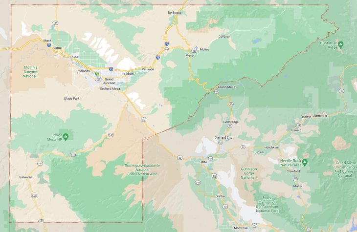
Map of Cities in Mesa County, CO

Map of Cities in Mesa County, CO