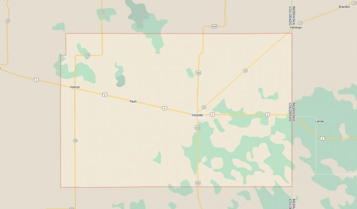
Cities and Towns in Phillips County, Colorado
Founded on 1889-03-27, Phillips County is one of 64 counties in the state of Colorado. Historically, Phillips County was split from Logan County. The city of Holyoke is the county seat. With FIPS code of 95, Phillips County has a population of 4,512 and area of 688.30 square miles (1,783 km²).
List of all cities in Phillips County, CO alphabetically
City/Town | Postal Code | Area Code |
Amherst, CO | 80721 | 970 |
Haxtun, CO | 80731 | 970 |
Holyoke, CO | 80734 | 970 |
Paoli, CO | 80746 | 970 |
Major Cities and Towns in Phillips County, Colorado
Holyoke
Area, Population, and Geography
- Area: 2.4 square miles
- Population: Approximately 2,300 (2023 estimate)
- Zip Codes: 80734
- Latitude: 40.5844° N
- Longitude: 102.3030° W
City Location and History
Holyoke, the county seat of Phillips County, is located in the northeastern part of Colorado, near the Nebraska border. The town was founded in 1887 when the Burlington & Missouri River Railroad extended its line into the area. Named after Holyoke, Massachusetts, by one of the town’s early settlers, Holyoke quickly developed as an agricultural community, taking advantage of the fertile soil of the High Plains. The town became a hub for grain and livestock production, and its economy has remained largely tied to agriculture. Over the years, Holyoke has maintained its small-town charm and agricultural roots, while also serving as a service center for the surrounding rural areas.
Major Schools and Landmarks
Holyoke is served by the Holyoke School District RE-1J, with Holyoke High School being the primary secondary school in the town. The town’s major landmarks include the Peerless Theatre, a historic movie theater built in 1929, which still operates today and is a beloved cultural venue for the community. The Phillips County Courthouse, a classic example of early 20th-century architecture, is another key landmark. The Holyoke Dragon Community Park offers recreational facilities, including sports fields and picnic areas. The town also hosts the annual Phillips County Fair, a significant event that celebrates the region’s agricultural heritage with livestock shows, rodeos, and community activities. Holyoke’s blend of historical significance, educational resources, and agricultural economy makes it a central and vibrant community in Phillips County.
Haxtun
Area, Population, and Geography
- Area: 0.6 square miles
- Population: Approximately 950 (2023 estimate)
- Zip Codes: 80731
- Latitude: 40.6414° N
- Longitude: 102.6294° W
City Location and History
Haxtun is a small town located in the eastern part of Phillips County, approximately 20 miles east of Holyoke. The town was established in the late 19th century, also as a result of the expansion of the railroad into the region. Haxtun was named after Haxton, England, although the name was slightly altered. The town grew as an agricultural community, primarily focused on wheat, corn, and cattle farming. Like many towns in the region, Haxtun’s economy is deeply rooted in agriculture, with grain elevators and farming equipment dealerships being prominent features of the local landscape. Despite its small size, Haxtun is known for its strong community spirit and active participation in local events.
Major Schools and Landmarks
Haxtun is served by the Haxtun School District RE-2J, with Haxtun High School providing education for students in the area. The town’s major landmarks include the Haxtun Community Center, which hosts a variety of local events, including the annual Corn Festival, a celebration of the town’s agricultural heritage with parades, games, and food. The Haxtun United Methodist Church, a historic building in the town, is a central gathering place for the community. The surrounding farmlands and open spaces reflect Haxtun’s agricultural roots, with opportunities for outdoor activities such as hunting and birdwatching. Haxtun’s combination of rural charm, educational resources, and community events makes it a significant town in Phillips County.
Paoli
Area, Population, and Geography
- Area: 0.1 square miles
- Population: Approximately 30 (2023 estimate)
- Zip Codes: 80746
- Latitude: 40.6100° N
- Longitude: 102.4738° W
City Location and History
Paoli is a very small town located in Phillips County, about 10 miles northwest of Holyoke. The town was established in 1888 as a station along the Burlington & Missouri River Railroad. Named after Paoli, Pennsylvania, the town was intended to serve the surrounding agricultural area, providing a shipping point for grain and livestock. Over time, Paoli remained a small, close-knit community, with a population that has fluctuated but always remained small. The town’s economy has always been centered on agriculture, with farming being the primary occupation of its residents. Despite its tiny size, Paoli has retained its identity as a rural community with deep agricultural roots.
Major Schools and Landmarks
Paoli does not have its own school district, and students typically attend schools in nearby Holyoke or Haxtun. The town’s major landmarks are limited due to its small size, but the Paoli Community Church serves as a central gathering place for residents. The surrounding farmland is a defining feature of the town, with wide-open spaces and agricultural operations dominating the landscape. The nearby South Platte River offers opportunities for fishing and small-scale outdoor recreation. Paoli’s combination of rural simplicity, agricultural focus, and close-knit community make it a unique and enduring part of Phillips County.