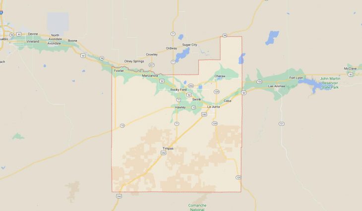
Cities and Towns in Otero County, Colorado
Founded on 1889-03-25, Otero County is one of 64 counties in the state of Colorado. Historically, Otero County was split from Bent County. The city of La Junta is the county seat. With FIPS code of 89, Otero County has a population of 18,594 and area of 1,267.66 square miles (3,283 km²).
List of all cities in Otero County, CO alphabetically
City/Town | Postal Code | Area Code |
Bents Fort, CO | 81050 | 719 |
Bents Old Fort, CO | 81050 | 719 |
Cheraw, CO | 81030 | 719 |
Fair View, CO | 81050 | 719 |
Fairmont, CO | 81050 | 719 |
Fort Bent, CO | 81050 | 719 |
Fowler, CO | 81039 | 719 |
Hawley, CO | 81067 | 719 |
La Junta, CO | 81050 | 719 |
Manzanola, CO | 81058 | 719 |
North La Junta, CO | 81050 | 719 |
Roberta, CO | 81050 | 719 |
Rocky Ford, CO | 81067 | 719 |
Swink, CO | 81077 | 719 |
Timber Lake, CO | 81050 | 719 |
Timpas, CO | 81050 | 719 |
Vroman, CO | 81067 | 719 |
Major Cities and Towns in Otero County, Colorado
La Junta
Area, Population, and Geography
- Area: 3.7 square miles
- Population: Approximately 7,100 (2023 estimate)
- Zip Codes: 81050
- Latitude: 37.9850° N
- Longitude: 103.5436° W
City Location and History
La Junta, the county seat and largest city in Otero County, is located in southeastern Colorado along the Arkansas River. The town was founded in 1875 as a railroad hub, originally serving as a division point for the Atchison, Topeka, and Santa Fe Railway. The name “La Junta,” which means “the junction” in Spanish, reflects its historical role as a key transportation and trading center. La Junta grew rapidly during the late 19th and early 20th centuries due to its strategic location and the development of agriculture in the Arkansas Valley. The town became an important center for the processing and distribution of agricultural products, particularly sugar beets, melons, and cattle. Today, La Junta continues to be an important regional center for agriculture, education, and healthcare, while also preserving its rich historical heritage.
Major Schools and Landmarks
La Junta is served by the East Otero School District R-1, with La Junta High School being the primary secondary school. The town is also home to Otero College, which offers a variety of academic and vocational programs. Major landmarks in La Junta include Bent’s Old Fort National Historic Site, a reconstructed 19th-century trading post that played a significant role in the westward expansion of the United States. The Koshare Indian Museum and Dancers, located on the Otero College campus, showcases Native American art and culture and is famous for its performances of traditional dances. The La Junta City Park and the nearby Vogel Canyon provide opportunities for outdoor recreation, including hiking, picnicking, and exploring the region’s natural beauty. La Junta’s blend of historical significance, educational resources, and community spirit make it a vital and dynamic city in Otero County.
Rocky Ford
Area, Population, and Geography
- Area: 1.7 square miles
- Population: Approximately 3,800 (2023 estimate)
- Zip Codes: 81067
- Latitude: 38.0511° N
- Longitude: 103.7205° W
City Location and History
Rocky Ford is a small town located in the Arkansas Valley in central Otero County, about 9 miles west of La Junta. The town was established in 1871 and named for a rocky ford on the Arkansas River that was used by early settlers. Rocky Ford quickly developed as an agricultural community, becoming especially known for its production of melons, cantaloupes in particular. By the late 19th century, Rocky Ford had earned a reputation as the “Melon Capital of the World,” and the town’s economy became closely tied to its agricultural output. The town continues to celebrate its agricultural heritage with annual events and festivals, attracting visitors from across the state.
Major Schools and Landmarks
Rocky Ford is served by the Rocky Ford School District R-2, with Rocky Ford High School being the main educational institution. The town’s major landmarks include the Rocky Ford Museum, which offers exhibits on the town’s history, including its agricultural roots and the development of the melon industry. The Arkansas Valley Fairgrounds, located in Rocky Ford, is the site of the annual Arkansas Valley Fair, one of the oldest fairs in Colorado, featuring livestock shows, rodeos, and agricultural exhibits. The Watermelon Day celebration, held during the fair, is a highlight of the town’s calendar, celebrating Rocky Ford’s legacy as a premier melon-growing region. The nearby Rocky Ford Wildlife Area provides opportunities for hunting, fishing, and birdwatching. Rocky Ford’s combination of agricultural heritage, community pride, and educational resources make it a significant town in Otero County.
Fowler
Area, Population, and Geography
- Area: 0.6 square miles
- Population: Approximately 1,200 (2023 estimate)
- Zip Codes: 81039
- Latitude: 38.1292° N
- Longitude: 104.0197° W
City Location and History
Fowler is a small town located in the northeastern part of Otero County, along the Arkansas River, about 28 miles west of La Junta. The town was founded in 1900 and named after Orson Squire Fowler, a phrenologist who was known for his work on the study of human character and temperament. Fowler developed as an agricultural community, with farming and ranching serving as the primary economic activities. The town has retained its rural charm and close-knit community spirit over the years, attracting residents who appreciate the slower pace of life and the town’s strong connection to its agricultural roots.
Major Schools and Landmarks
Fowler is served by the Fowler School District R-4J, with Fowler High School being the main secondary school. The town’s major landmarks include the Fowler Historical Society and Museum, which preserves the history of the area with exhibits on early settlers, agriculture, and local events. The Fowler City Park offers recreational facilities, including sports fields, picnic areas, and a swimming pool, serving as a gathering place for community events and activities. The town hosts an annual Fowler Harvest Festival, celebrating the region’s agricultural heritage with parades, games, and local produce. The nearby John Martin Reservoir provides opportunities for boating, fishing, and camping, making it a popular destination for outdoor enthusiasts. Fowler’s combination of rural charm, historical significance, and community events makes it a cherished town in Otero County.
Manzanola
Area, Population, and Geography
- Area: 0.2 square miles
- Population: Approximately 400 (2023 estimate)
- Zip Codes: 81058
- Latitude: 38.1097° N
- Longitude: 103.8672° W
City Location and History
Manzanola is a small town located in the northwestern part of Otero County, along the Arkansas River, about 20 miles west of La Junta. The town was founded in the early 20th century and its name is derived from the Spanish words “manzana,” meaning apple, and “ola,” meaning wave, reflecting the area’s history of fruit orchards and agriculture. Manzanola developed as a farming community, with its economy centered around the production of crops such as apples, melons, and grains. The town has maintained its agricultural identity over the years, with farming remaining a key part of the local economy.
Major Schools and Landmarks
Manzanola is served by the Manzanola School District 3J, with Manzanola High School providing education for local students. The town’s major landmarks include the historic Manzanola Town Hall, which serves as a central location for community meetings and events. The Manzanola Community Park offers recreational facilities, including sports fields and playgrounds, and is a popular spot for local gatherings. The surrounding farmland reflects the town’s agricultural roots, with wide-open spaces and fields that change with the seasons. The town’s small size and close-knit community are celebrated during local events such as the annual Harvest Festival, which showcases the agricultural products and traditions of the region. Manzanola’s combination of agricultural heritage, rural charm, and community spirit make it an important part of Otero County.
Cheraw
Area, Population, and Geography
- Area: 0.1 square miles
- Population: Approximately 250 (2023 estimate)
- Zip Codes: 81030
- Latitude: 38.1075° N
- Longitude: 103.5119° W
City Location and History
Cheraw is a small town located in the eastern part of Otero County, near the Arkansas River, about 12 miles north of La Junta. The town was established in the late 19th century and was named after Cheraw, South Carolina, reflecting the origin of some of its early settlers. Cheraw developed as an agricultural community, with its economy centered on farming and ranching. The town has retained its rural character and close-knit community, with agriculture continuing to play a central role in the local economy. Cheraw is known for its quiet, peaceful atmosphere and strong sense of community, making it an appealing place for residents who appreciate small-town living.
Major Schools and Landmarks
Cheraw is served by the Cheraw School District 31, with Cheraw High School being the primary educational institution. The town’s major landmarks include the historic Cheraw School, which serves as both a school and a community center, hosting various events and activities throughout the year. The Cheraw Community Park offers recreational facilities, including a playground and picnic areas, and serves as a gathering place for local residents. The town is surrounded by farmland, reflecting its agricultural roots and providing a scenic backdrop for the community. Cheraw’s annual events, such as the community picnic and holiday celebrations, reflect the town’s strong sense of community and pride in its agricultural heritage. Cheraw’s combination of rural charm, educational resources, and community spirit make it a valued part of Otero County.