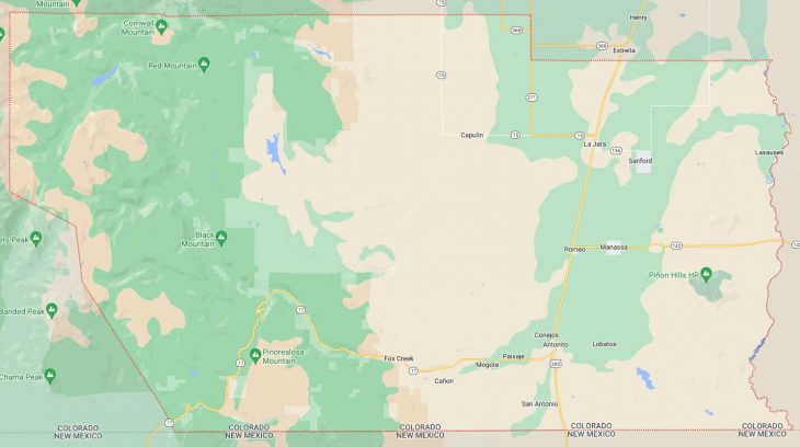
Cities and Towns in Conejos County, Colorado

Founded on 1861-11-01, Conejos County is one of 64 counties in the state of Colorado. Historically, Conejos County was formed from Guadalupe County, one of the 17 original counties of the Territory of Colorado, was renamed Conejos County after six days on November 7, 1861. The city of Conejos is the county seat. With FIPS code of 21, Conejos County has a population of 7,612 and area of 1,290.22 square miles (3,342 km²).

List of all cities in Conejos County, CO alphabetically

City/Town Postal Code Area Code
Antonito, CO 81120 719
Bountiful, CO 81140 719
Capulin, CO 81124 719
Conejos, CO 81129 719
Espinoza, CO 81120 719
Florida, CO 81120 719
Fox Creek, CO 81120 719
La Isla, CO 81120 719
La Jara, CO 81140 719
Las Mesitas, CO 81120 719
Lasauses, CO 81151 719
Lobatos, CO 81120 719
Los Pinas, CO 81120 719
Manassa, CO 81141 719
Mogote, CO 81120 719
Morgan, CO 81140 719
Ortiz, CO 81120 719
Paisaje, CO 81120 719
Richfield, CO 81140 719
Romeo, CO 81148 719
San Acacio, CO 81151 719
San Antonio, CO 81120 719
San Miguel, CO 81120 719
San Rafeal, CO 81120 719
Sanford, CO 81151 719
Track City, CO 81120 719

Major Cities and Towns in Conejos County, Colorado

Conejos

Area, Population, Zip Codes, and Coordinates

  • Area: N/A (unincorporated community)
  • Population: Approximately 60 (2023 estimate)
  • Zip Codes: 81129
  • Latitude and Longitude: 37.0883° N, 106.0300° W

Location and History

Conejos, one of the oldest communities in Colorado, was established in 1854 by Hispanic settlers from New Mexico. The town is located in the San Luis Valley along the Conejos River, which provided the community with fertile land for farming and ranching. Conejos became an important religious and cultural center in the region, with the establishment of the Our Lady of Guadalupe Parish in 1858, the oldest church in Colorado still in use. The town’s name, “Conejos,” means “rabbits” in Spanish, reflecting the abundance of wildlife in the area. Though it has remained small, Conejos holds a significant place in the history of Colorado, particularly for its early Hispanic heritage.

Major Schools and Landmarks

Conejos is served by the North Conejos School District, with students typically attending schools in nearby Antonito or La Jara. The most prominent landmark in Conejos is the Our Lady of Guadalupe Church, which stands as a testament to the town’s long history and cultural importance. The town’s location along the Conejos River also provides opportunities for fishing and enjoying the scenic beauty of the San Luis Valley. Conejos is a quiet, rural community with a deep connection to its history and traditions, making it an important part of Conejos County’s cultural landscape.

Antonito

Area, Population, Zip Codes, and Coordinates

  • Area: 0.5 square miles
  • Population: Approximately 750 (2023 estimate)
  • Zip Codes: 81120
  • Latitude and Longitude: 37.0761° N, 106.0097° W

Location and History

Antonito, located in the southern part of Conejos County near the New Mexico border, was founded in 1881 as a railroad town. Originally named “San Antonio Junction,” the town grew quickly due to its position as a key stop along the Denver and Rio Grande Western Railroad. Antonito served as a commercial and transportation hub for the surrounding agricultural region. The town is known for its strong Hispanic heritage, which is reflected in its culture, architecture, and community events. Over the years, Antonito has retained its small-town charm while continuing to serve as a gateway to the rich cultural and natural attractions of the San Luis Valley.

Major Schools and Landmarks

Antonito is served by the North Conejos School District, with Antonito High School and Antonito Elementary School being the primary educational institutions. Major landmarks in Antonito include the Cumbres & Toltec Scenic Railroad, a historic narrow-gauge railway that offers scenic rides through the San Juan Mountains, providing a glimpse into the region’s railroading past. The town is also home to the historic Our Lady of Guadalupe Church, which plays a central role in the community’s religious life. The surrounding area offers opportunities for outdoor recreation, including hiking, fishing, and exploring the nearby Rio Grande National Forest. Antonito’s blend of history, culture, and scenic beauty makes it a unique and vibrant community in Conejos County.

La Jara

Area, Population, Zip Codes, and Coordinates

  • Area: 0.3 square miles
  • Population: Approximately 800 (2023 estimate)
  • Zip Codes: 81140
  • Latitude and Longitude: 37.2772° N, 105.9586° W

Location and History

La Jara is a small town located in the northern part of Conejos County, within the San Luis Valley. The town was established in 1890 as a farming and ranching community, with its name derived from the Spanish word for “the willows,” reflecting the vegetation found along nearby streams. La Jara quickly became a central point for the local agricultural economy, serving as a market town for the surrounding rural areas. The town’s history is closely tied to the development of the San Luis Valley’s irrigation systems, which allowed for the expansion of farming in the arid region. Today, La Jara remains a tight-knit community with deep agricultural roots.

Major Schools and Landmarks

La Jara is served by the North Conejos School District, with Centauri High School and La Jara Elementary School being key educational institutions. Major landmarks in La Jara include the historic La Jara Trading Post, which has served the community for over a century, and the nearby La Jara Reservoir, which offers fishing, boating, and birdwatching opportunities. The town is also home to the North Conejos Veterans Memorial, honoring local residents who have served in the military. La Jara’s small-town atmosphere, combined with its agricultural heritage and scenic surroundings, make it a welcoming and resilient community in Conejos County.

Manassa

Area, Population, Zip Codes, and Coordinates

  • Area: 0.7 square miles
  • Population: Approximately 950 (2023 estimate)
  • Zip Codes: 81141
  • Latitude and Longitude: 37.1742° N, 105.9375° W

Location and History

Manassa is a small town in Conejos County, founded in 1878 by Mormon pioneers who settled in the San Luis Valley. The town is named after Manasseh, a figure from the Bible, reflecting the religious heritage of its founders. Manassa developed as an agricultural community, with farming and livestock operations playing a central role in the local economy. The town is best known as the birthplace of Jack Dempsey, the world heavyweight boxing champion in the 1920s, often referred to as the “Manassa Mauler.” Manassa’s history is deeply intertwined with the broader history of Mormon settlement in Colorado, and it continues to be a strong, community-oriented town with a rich cultural heritage.

Major Schools and Landmarks

Manassa is part of the North Conejos School District, with students attending schools in nearby La Jara and Antonito. The town’s most famous landmark is the Jack Dempsey Museum, located in the house where the boxing legend was born. The museum celebrates Dempsey’s life and career, attracting visitors from around the world. Manassa is also home to the annual Manassa Pioneer Days, a festival that includes parades, rodeos, and other events celebrating the town’s pioneer heritage. The town’s strong sense of community, agricultural traditions, and historical significance make Manassa an important part of Conejos County’s cultural fabric.

Romeo

Area, Population, Zip Codes, and Coordinates

  • Area: 0.2 square miles
  • Population: Approximately 400 (2023 estimate)
  • Zip Codes: 81148
  • Latitude and Longitude: 37.1758° N, 105.9858° W

Location and History

Romeo is a small town located just south of La Jara in Conejos County. The town was established in the late 19th century as a farming and ranching community. Romeo developed as a residential area for workers and families involved in the agricultural industry that dominates the San Luis Valley. The town’s name is believed to be derived from the Spanish word “Romeo,” though the exact origin of the name is uncertain. Over the years, Romeo has remained a small, close-knit community with a strong focus on agriculture and family life.

Major Schools and Landmarks

Romeo is served by the North Conejos School District, with students attending schools in nearby La Jara and Antonito. The town’s landmarks include its historic churches and small family farms, which are integral to the local economy and way of life. The nearby Alamosa National Wildlife Refuge offers opportunities for birdwatching and enjoying the natural beauty of the San Luis Valley. Romeo’s small size and strong community ties make it a quiet and peaceful place to live, with a deep connection to the agricultural traditions of Conejos County.

Map of Cities in Conejos County, CO

Map of Cities in Conejos County, CO