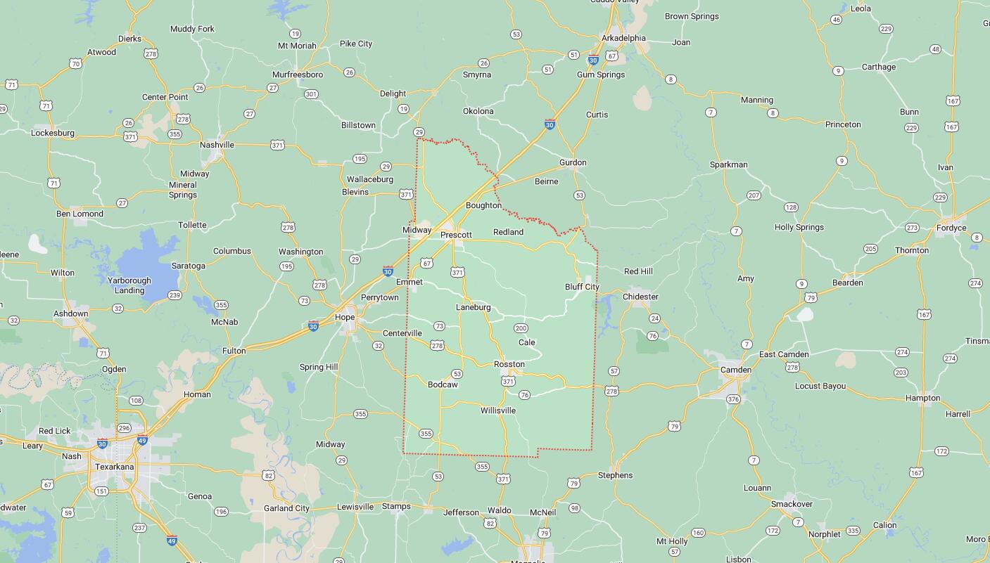
Cities and Towns in Nevada County, Arkansas
Founded on March 20, 1871, Nevada County is one of 75 counties in the state of Arkansas. Historically, Nevada County was formed from Columbia, Hempstead, and Ouachita counties. The city of Prescott is the county seat. With FIPS code of 99, Nevada County has a population of 8,187 and area of 620.78 square miles (1,608 km²).
List of all cities in Nevada County, AR alphabetically
| City/Town | Postal Code | Area Code |
| Bluff City, AR | 71722 | 870 |
| Cale, AR | 71828 | 870 |
| Emmet, AR | 71835 | 870 |
| Laneburg, AR | 71857 | 870 |
| Prescott, AR | 71857 | 870 |
| Rosston, AR | 71858 | 870 |
| Willisville, AR | 71864 | 870 |
Major Cities and Towns in Nevada County, Arkansas
Prescott
- Area: 6.8 square miles
- Population: 3,087 (2020 Census)
- ZIP Codes: 71857
- Latitude and Longitude: 33.8027° N, 93.3893° W
Location and History
Prescott, the county seat of Nevada County, Arkansas, is located in the southwestern part of the state along U.S. Highway 67. Founded in 1873 and named after the President of the Cairo & Fulton Railroad, Prescott quickly grew as a result of the railroad’s influence. The town’s strategic location along the rail line made it a key shipping point for timber, cotton, and other agricultural products, contributing to its early prosperity. Prescott’s history is deeply tied to the railroad, which played a crucial role in its development and economic growth. The town’s economy was historically driven by agriculture and timber, with sawmills and cotton gins dotting the landscape. Over the years, Prescott has maintained its small-town charm while serving as a regional hub for commerce and government. The town is known for its historic downtown, featuring several buildings listed on the National Register of Historic Places.
Major Schools and Landmarks
Prescott is served by the Prescott School District, which includes Prescott High School, known for its strong academic programs and active participation in sports and extracurricular activities. Major landmarks in Prescott include the Nevada County Courthouse, a historic building that reflects the town’s role as the county seat, and the 1912 Missouri-Pacific Railroad Depot, which now houses a museum showcasing the town’s rich railroad history. The nearby Prairie D’Ane Battlefield is a significant Civil War site where Union and Confederate forces clashed in 1864. Prescott’s annual events, such as the Fall Festival and Trade Days, bring the community together and celebrate the town’s heritage with parades, live music, and local crafts. Prescott’s combination of historical significance, educational opportunities, and strong community ties make it a vibrant and welcoming place in Nevada County.
Emmet
- Area: 1.6 square miles
- Population: 451 (2020 Census)
- ZIP Codes: 71835
- Latitude and Longitude: 33.7268° N, 93.4683° W
Location and History
Emmet is a small town located in the northwestern part of Nevada County, Arkansas, near the boundary with Hempstead County. The town was established in the late 19th century and named after Emmet McNair, a prominent local businessman and landowner. Emmet grew primarily as an agricultural community, with its economy based on farming and timber. The arrival of the railroad in the late 19th century further boosted the town’s growth, making it an important shipping point for agricultural products, particularly cotton. Over the years, Emmet has remained a small, close-knit community with a strong emphasis on family and tradition. The town’s history is closely tied to its rural roots, with many of its residents being descendants of the original settlers who farmed the area for generations.
Major Schools and Landmarks
Emmet is part of the Prescott School District, with students attending schools in nearby Prescott. The town itself is small, with a few local businesses and a rural setting that offers a peaceful lifestyle. Significant landmarks in Emmet include the historic Emmet Methodist Church, which has served as a community center for over a century. The town is also home to several historic homes and buildings that reflect its rich agricultural heritage. The nearby White Oak Lake State Park offers opportunities for fishing, boating, and camping, making it a popular destination for outdoor enthusiasts. Emmet’s annual community events, such as local fairs and church gatherings, help maintain the town’s close-knit atmosphere and celebrate its agricultural roots. The town’s rural charm, scenic surroundings, and strong community bonds make Emmet a quintessential example of small-town life in Nevada County.
Bluff City
- Area: 0.4 square miles
- Population: 158 (2020 Census)
- ZIP Codes: 71722
- Latitude and Longitude: 33.7046° N, 93.1060° W
Location and History
Bluff City is a small town located in the eastern part of Nevada County, Arkansas. The town was established in the late 19th century and was originally known as “Bluff Springs” due to the natural springs that were abundant in the area. Bluff City developed as a farming community, with cotton being the primary crop grown by local farmers. The town’s location near the Ouachita River provided fertile land and easy access to water, which were crucial for agriculture. Over the years, Bluff City has remained a small, rural community with a strong emphasis on family, tradition, and agriculture. The town’s history is closely tied to the land, with many of its residents being descendants of the original settlers who farmed the area for generations.
Major Schools and Landmarks
Bluff City is part of the Nevada School District, with students attending schools in nearby Prescott or Rosston. The town itself is small, with few commercial establishments, but it is surrounded by beautiful natural landscapes that provide opportunities for outdoor recreation. Significant landmarks in Bluff City include the historic Bluff City Baptist Church, which has served as a community gathering place for many years. The nearby Poison Springs Battleground State Park, a significant Civil War site, offers opportunities for hiking and historical exploration, attracting visitors to the area. Bluff City’s annual community events, such as local picnics and church gatherings, help maintain the town’s close-knit atmosphere and celebrate its agricultural heritage. The town’s rural charm, scenic surroundings, and strong community bonds make Bluff City a quintessential example of small-town life in Nevada County.
Bodcaw
- Area: 1.6 square miles
- Population: 132 (2020 Census)
- ZIP Codes: 71858
- Latitude and Longitude: 33.5682° N, 93.3493° W
Location and History
Bodcaw is a small town located in the southwestern part of Nevada County, Arkansas. The town was established in the late 19th century and was named after the nearby Bodcaw Creek. Bodcaw developed as an agricultural community, with its economy based on farming, livestock, and timber. The town’s location in the fertile lands of the Arkansas Delta made it an ideal place for agriculture, particularly cotton and other cash crops. Over the years, Bodcaw has remained a small, close-knit community with a strong emphasis on family, tradition, and rural values. The town’s history is closely tied to the land, with many of its residents being descendants of the original settlers who farmed the area for generations.
Major Schools and Landmarks
Bodcaw is part of the Nevada School District, with students attending schools in nearby Rosston. The town itself is small, with a few local businesses and a rural setting that offers a peaceful lifestyle. Significant landmarks in Bodcaw include the historic Bodcaw Methodist Church, which has served as a community center for many years. The town is also home to several historic homes and buildings that reflect its rich agricultural heritage. The nearby White Oak Lake State Park offers opportunities for fishing, boating, and camping, making it a popular destination for outdoor enthusiasts. Bodcaw’s annual community events, such as local fairs and church gatherings, help maintain the town’s close-knit atmosphere and celebrate its agricultural roots. The town’s rural charm, scenic surroundings, and strong community bonds make Bodcaw a quintessential example of small-town life in Nevada County.
Cale
- Area: 0.9 square miles
- Population: 74 (2020 Census)
- ZIP Codes: 71828
- Latitude and Longitude: 33.6040° N, 93.2529° W
Location and History
Cale is a very small town located in the central part of Nevada County, Arkansas. The town was established in the early 20th century and named after Cale Ward, an early settler in the area. Cale developed as a rural farming community, with agriculture being the primary economic activity. The town’s location in the fertile lands of southwest Arkansas made it an ideal place for farming, particularly cotton and soybeans. Over the years, Cale has remained a small, close-knit community with a strong emphasis on family, tradition, and rural values. The town’s history is closely tied to the land, and its development has been shaped by the agricultural practices that have sustained it for generations.
Major Schools and Landmarks
Cale is part of the Nevada School District, with students attending schools in nearby Rosston. The town is small, with few commercial establishments, but it is surrounded by beautiful natural landscapes that provide opportunities for outdoor recreation. Significant landmarks in Cale include the historic Cale Baptist Church, which has served as a community gathering place for many years. The town is also located near the Poison Springs Battleground State Park, which offers opportunities for hiking and historical exploration. Cale’s annual community events, such as local fairs and church gatherings, help maintain the town’s close-knit atmosphere and celebrate its agricultural heritage. The town’s rural charm, scenic surroundings, and strong community bonds make Cale a quintessential example of small-town life in Nevada County.
Map of Cities in Nevada County, AR