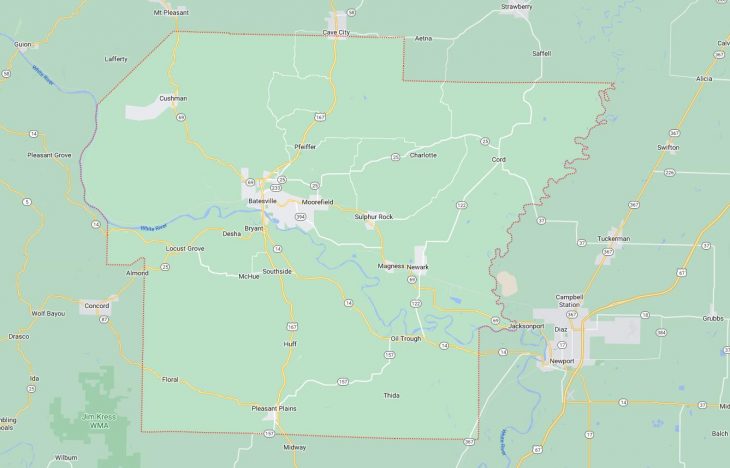
Cities and Towns in Independence County, Arkansas
Founded on October 20, 1820, Independence County is one of 75 counties in the state of Arkansas. Historically, Independence County was formed from Lawrence County (1820). The city of Batesville is the county seat. With FIPS code of 63, Independence County has a population of 37,723 and area of 771.57 square miles (1,998 km²).
List of all cities in Independence County, AR alphabetically
City/Town | Postal Code | Area Code |
Batesville, AR | 72501 | 870 |
72503 | 870 | |
Charlotte, AR | 72522 | 870 |
Cord, AR | 72524 | 870 |
Cushman, AR | 72526 | 870 |
Desha, AR | 72527 | 870 |
Floral, AR | 72534 | 870 |
Locust Grove, AR | 72550 | 870 |
Magness, AR | 72553 | 870 |
Newark, AR | 72562 | 870 |
Oil Trough, AR | 72564 | 870 |
Pleasant Plns, AR | 72568 | 501 |
Rosie, AR | 72571 | 870 |
Salado, AR | 72575 | 870 |
Sulphur Rock, AR | 72579 | 870 |
Thida, AR | 72165 | 870 |
Major Cities and Towns in Independence County, Arkansas
Batesville
Area, Population, and Coordinates
- Area: 11.1 square miles
- Population: 10,248 (as of the last census)
- ZIP Codes: 72501, 72503
- Latitude and Longitude:
- Latitude: 35.7698° N
- Longitude: 91.6400° W
Location and History
Batesville is the county seat and largest city in Independence County, Arkansas. Founded in 1821, it is one of the oldest cities in the state. Batesville was established as a river port on the White River and quickly became an important center for trade and transportation. The city’s strategic location along the river allowed it to flourish as a hub for commerce, particularly in the early years of Arkansas’s statehood. Batesville has a rich history, with many of its buildings and neighborhoods reflecting the architectural styles of the 19th and early 20th centuries. Today, Batesville is a thriving community that blends its historical heritage with modern development, making it a key city in the region.
Major Schools and Landmarks
Batesville is served by the Batesville School District, which includes Batesville High School, Batesville Junior High School, and several elementary schools. The city is also home to Lyon College, a private liberal arts college known for its strong academic programs and beautiful campus. Key landmarks in Batesville include the Old Independence Regional Museum, which offers exhibits on the history and culture of the region, and the White River, which provides opportunities for fishing, boating, and other outdoor activities. The city’s annual White River Water Carnival is a major event, celebrating Batesville’s connection to the river with a weekend of festivities, including parades, live music, and family-friendly activities.
Southside
Area, Population, and Coordinates
- Area: 5.8 square miles
- Population: 3,984 (as of the last census)
- ZIP Codes: 72501
- Latitude and Longitude:
- Latitude: 35.7061° N
- Longitude: 91.6221° W
Location and History
Southside is a small town located just south of Batesville in Independence County, Arkansas. The town was officially incorporated in 2004, making it one of the newer municipalities in the county. Southside developed as a suburban community for those working in Batesville and the surrounding areas. The town is known for its quiet, residential neighborhoods and its strong sense of community. Despite its relatively recent incorporation, Southside has quickly established itself as a growing community with a focus on providing a high quality of life for its residents.
Major Schools and Landmarks
Southside is served by the Southside School District, which includes Southside High School, Southside Junior High School, and Southside Elementary School. The town is home to several local landmarks, including the Southside Church of Christ, which has become a central gathering place for the community. The surrounding countryside offers opportunities for outdoor activities, such as hiking, fishing, and birdwatching, reflecting Southside’s rural character. The town’s annual events, such as the Southside Fall Festival, bring residents together to celebrate their shared values and foster a strong sense of community pride.
Newark
Area, Population, and Coordinates
- Area: 1.5 square miles
- Population: 1,176 (as of the last census)
- ZIP Codes: 72562
- Latitude and Longitude:
- Latitude: 35.7057° N
- Longitude: 91.4406° W
Location and History
Newark is a small town located in the southeastern part of Independence County, Arkansas. The town was established in the late 19th century and developed as a railroad town, with agriculture being the primary economic activity. Newark’s location along the railroad line made it an important stop for the transportation of goods, particularly cotton and other crops grown in the region. Over time, the town has maintained its rural charm and close-knit community atmosphere, with a focus on preserving its agricultural heritage.
Major Schools and Landmarks
Newark is served by the Cedar Ridge School District, which includes Cedar Ridge High School and Newark Elementary School. The town is home to several local landmarks, including the historic Newark Baptist Church, which has been a central part of the community for many years. The nearby White River and surrounding farmland offer opportunities for fishing, boating, and other outdoor activities, reflecting Newark’s connection to the natural environment. The town’s annual events, such as the Newark Watermelon Festival, bring residents together to celebrate their shared heritage and foster a strong sense of community pride.
Cave City
Area, Population, and Coordinates
- Area: 3.1 square miles
- Population: 1,904 (as of the last census)
- ZIP Codes: 72521
- Latitude and Longitude:
- Latitude: 35.9412° N
- Longitude: 91.5482° W
Location and History
Cave City is a small town located in the northern part of Independence County, Arkansas. The town was established in the late 19th century and is known for its natural springs and caves, which were popular attractions for early settlers. Cave City developed as an agricultural community, with fruit orchards, particularly watermelons, becoming a significant part of the local economy. The town is famously known as the “Home of the World’s Sweetest Watermelons,” a title that reflects its long-standing tradition of watermelon farming.
Major Schools and Landmarks
Cave City is served by the Cave City School District, which includes Cave City High School, Cave City Middle School, and Cave City Elementary School. The town is home to several local landmarks, including the Cave City Park, which features natural springs and picnic areas, making it a popular destination for residents and visitors alike. The annual Cave City Watermelon Festival is the town’s most famous event, drawing visitors from across the region to celebrate the watermelon harvest with a parade, live music, and various family-friendly activities. Cave City’s rich agricultural heritage and scenic beauty make it a unique and vibrant community in Independence County.