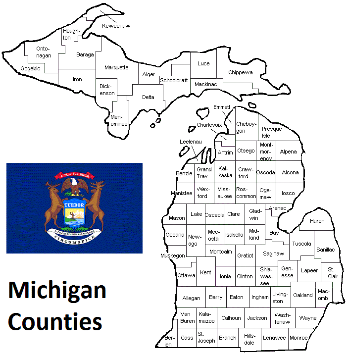
Michigan Counties. List Alphabetically (and by Population)
How many counties are there in Michigan? As of 2024, there are a total of 83 counties in the state of Michigan. Among them, Wayne County is the oldest one (established in 1815) while Dickinson County is the youngest (established in 1891). With population of 1,820,584, Wayne County is the most populated. The biggest county by land area is Keweenaw County (15,452 km²) and the smallest is Cass County (1,316 km²).
Largest Counties in Michigan
1. Wayne County
County Seat: Detroit
- Area: 673 square miles
- Population: Approximately 1,793,561
- Area Codes: 313, 734
- Latitude and Longitude: 42.2790° N, 83.1551° W
Location and History
Wayne County, located in southeastern Michigan, is the most populous county in the state and home to Detroit, the largest city in Michigan. Established in 1796, it was one of the original counties formed after the Northwest Territory was established. The county’s early history is closely tied to Detroit’s development as a major industrial center, particularly in the automotive industry. Detroit earned the nickname “Motor City” due to the presence of major automobile manufacturers like Ford, General Motors, and Chrysler. Over the years, Wayne County has been a hub of innovation, industry, and culture, despite facing significant economic challenges in the late 20th century.
Major Highways and Landmarks
Wayne County is crisscrossed by several major highways, including Interstate 75, which runs north-south through the county, and Interstate 94, which connects Detroit to Chicago and other parts of Michigan. Interstate 96 also serves the county, providing a direct route to the western parts of the state. Notable landmarks include the Detroit Institute of Arts, which houses one of the most significant art collections in the country, and the Henry Ford Museum in Dearborn, which showcases the history of American innovation. The county is also home to the iconic Renaissance Center, Detroit’s riverfront skyscraper complex, and the Detroit Riverwalk, a popular destination for residents and visitors alike.
2. Oakland County
County Seat: Pontiac
- Area: 907 square miles
- Population: Approximately 1,253,185
- Area Codes: 248, 947, 810
- Latitude and Longitude: 42.6612° N, 83.3855° W
Location and History
Oakland County is located in southeastern Michigan, immediately north of Wayne County. Established in 1819, the county was named after the large oak forests that once covered the region. Oakland County has evolved from a rural, agricultural area into one of the most affluent and economically diverse counties in the United States. The county has a mix of urban, suburban, and rural areas, with a strong focus on automotive research, finance, and technology. Over the years, cities like Troy, Rochester Hills, and Farmington Hills have become key business and residential centers, contributing to the county’s economic growth and high quality of life.
Major Highways and Landmarks
Oakland County is well-connected by major highways, including Interstate 75, which runs through the heart of the county, and Interstate 696, which serves as an east-west connector to other parts of the Detroit metropolitan area. U.S. Route 24 and M-59 are also significant routes within the county. Key landmarks include the Cranbrook Educational Community in Bloomfield Hills, known for its schools, museum, and art academy, and the Detroit Zoo in Royal Oak, a major attraction in the region. The county is also home to several scenic parks and lakes, including Kensington Metropark and the expansive Oakland County Parks system, offering ample opportunities for outdoor recreation.
3. Macomb County
County Seat: Mount Clemens
- Area: 570 square miles
- Population: Approximately 881,217
- Area Codes: 586, 810
- Latitude and Longitude: 42.7169° N, 82.8203° W
Location and History
Macomb County is situated in southeastern Michigan, bordered by Lake St. Clair to the east and Wayne County to the south. The county was established in 1818 and named after General Alexander Macomb, a hero of the War of 1812. Historically, Macomb County was a rural, agricultural area, but it has since transformed into a suburban region with a strong industrial base, particularly in the automotive and defense sectors. The county’s growth accelerated after World War II, driven by the expansion of the Detroit metropolitan area and the rise of suburban living.
Major Highways and Landmarks
Macomb County is served by major highways such as Interstate 94, which runs along the eastern part of the county, and M-59, a key east-west corridor. Interstate 696 also provides a crucial link to the western suburbs and Detroit. Notable landmarks in Macomb County include Lake St. Clair Metropark, a popular destination for boating, fishing, and swimming, and the General Motors Technical Center in Warren, a major research and development facility. The county is also home to the historic town of Mount Clemens, known for its mineral baths and charming downtown area, as well as the sprawling Freedom Hill County Park, which hosts concerts and community events.
4. Kent County
County Seat: Grand Rapids
- Area: 872 square miles
- Population: Approximately 657,974
- Area Codes: 616
- Latitude and Longitude: 43.0097° N, 85.6824° W
Location and History
Kent County is located in western Michigan, with Grand Rapids as its county seat and largest city. The county was established in 1831 and named after James Kent, a prominent jurist from New York. Kent County’s history is closely tied to the development of Grand Rapids, known as the “Furniture City” due to its historical dominance in the furniture manufacturing industry. Over the years, Kent County has diversified its economy, becoming a center for healthcare, education, and the arts. The county’s population has grown steadily, and Grand Rapids has become one of Michigan’s most vibrant cities, known for its craft beer industry and cultural institutions.
Major Highways and Landmarks
Kent County is well-connected by major highways, including Interstate 96, which runs east-west through the county, and U.S. Route 131, a key north-south corridor. Interstate 196 also serves the area, connecting Grand Rapids to the Lake Michigan shoreline. Notable landmarks include the Gerald R. Ford Presidential Museum, which honors the 38th President of the United States, and the Frederik Meijer Gardens & Sculpture Park, a renowned botanical garden and art park. The county is also home to the Grand Rapids Art Museum, known for its contemporary art collection, and the DeVos Place Convention Center, a key venue for events and conferences.
5. Genesee County
County Seat: Flint
- Area: 649 square miles
- Population: Approximately 406,892
- Area Codes: 810
- Latitude and Longitude: 43.0125° N, 83.6875° W
Location and History
Genesee County is located in southeastern Michigan, with Flint as its county seat and largest city. Established in 1835, the county was named after Genesee County in New York, from where many early settlers originated. Flint, the county seat, played a crucial role in the rise of the American automotive industry, particularly as the birthplace of General Motors. The city was also a center of labor activism, with the Flint Sit-Down Strike of 1936-37 marking a pivotal moment in U.S. labor history. Despite facing significant economic challenges in recent decades, Genesee County remains a key part of Michigan’s industrial heritage.
Major Highways and Landmarks
Genesee County is traversed by several major highways, including Interstate 75, which runs north-south through the county, and Interstate 69, which runs east-west, providing connections to Lansing and Port Huron. U.S. Route 23 also serves the county, linking it to Ann Arbor and the rest of southeastern Michigan. Notable landmarks include the Sloan Museum and Longway Planetarium, which offer insights into Flint’s industrial history and the wonders of the universe. The county is also home to the Flint Institute of Arts, one of the largest art museums in Michigan, and the historic Crossroads Village and Huckleberry Railroad, a living history museum that showcases life in the 19th century.
6. Washtenaw County
County Seat: Ann Arbor
- Area: 722 square miles
- Population: Approximately 372,258
- Area Codes: 734, 313
- Latitude and Longitude: 42.2590° N, 83.7049° W
Location and History
Washtenaw County is located in southeastern Michigan, west of Wayne County. The county was established in 1826, and its name is derived from a Native American word meaning “far away waters.” Washtenaw County is home to Ann Arbor, one of Michigan’s most dynamic cities, known for being the home of the University of Michigan. The university has played a central role in the county’s development, making it a hub for education, research, and technology. The county has a mix of urban and rural areas, with Ann Arbor serving as a cultural and economic center, while the surrounding towns and countryside offer a more relaxed, suburban lifestyle.
Major Highways and Landmarks
Washtenaw County is served by major highways such as Interstate 94, which runs east-west through the county, and U.S. Route 23, which runs north-south, connecting the area to Flint and Toledo, Ohio. M-14 also provides a direct route from Ann Arbor to Detroit. Notable landmarks include the University of Michigan campus, which features historic buildings, museums, and the renowned Michigan Stadium, the largest stadium in the United States. The county is also home to the Matthaei Botanical Gardens and Nichols Arboretum, offering beautiful natural landscapes, and the Ann Arbor Hands-On Museum, which provides interactive science exhibits for all ages.
7. Ingham County
County Seat: Mason and Lansing
- Area: 561 square miles
- Population: Approximately 292,735
- Area Codes: 517
- Latitude and Longitude: 42.6046° N, 84.4797° W
Location and History
Ingham County is located in central Michigan, with Mason as the county seat and Lansing, the state capital, also located within the county. The county was established in 1829 and named after Samuel D. Ingham, a U.S. Secretary of the Treasury. Ingham County is unique in that it serves as the political and administrative center of Michigan, with Lansing being the seat of state government. The county has a diverse economy, with government, education, and healthcare being major sectors. Michigan State University, located in East Lansing, is one of the largest and most prestigious universities in the country, playing a significant role in the county’s development.
Major Highways and Landmarks
Ingham County is well-connected by major highways, including Interstate 69, which runs north-south through the county, and Interstate 96, which runs east-west, providing access to Grand Rapids and Detroit. U.S. Route 127 also serves the area, connecting it to northern and southern Michigan. Notable landmarks include the Michigan State Capitol in Lansing, an iconic symbol of state government, and the Michigan State University campus, known for its historic buildings, botanical gardens, and museums. The county is also home to the Potter Park Zoo, one of the oldest zoos in Michigan, and the Lansing River Trail, offering scenic views of the Grand River.
8. Ottawa County
County Seat: Grand Haven
- Area: 1,631 square miles
- Population: Approximately 299,032
- Area Codes: 616
- Latitude and Longitude: 42.9536° N, 86.1701° W
Location and History
Ottawa County is located in western Michigan, along the eastern shore of Lake Michigan. The county was established in 1837 and named after the Ottawa people, a Native American tribe that inhabited the region. Ottawa County has a rich agricultural history, particularly in fruit growing and dairy farming, and has also developed a strong manufacturing base. The county’s location along Lake Michigan has made it a popular destination for tourism and recreation, with its sandy beaches, dunes, and parks attracting visitors from across the state and beyond.
Major Highways and Landmarks
Ottawa County is served by major highways such as Interstate 196, which runs north-south through the county, and U.S. Route 31, which parallels the Lake Michigan shoreline. M-45, also known as Lake Michigan Drive, provides a direct route from Grand Rapids to the lakefront. Notable landmarks include Holland State Park, known for its beautiful beach and iconic Big Red Lighthouse, and the Windmill Island Gardens in Holland, which features a working Dutch windmill and tulip gardens. The county is also home to the Grand Haven State Park, a popular destination for camping, swimming, and fishing, and the vibrant downtown area of Grand Haven, known for its waterfront, shops, and restaurants.
9. Kalamazoo County
County Seat: Kalamazoo
- Area: 580 square miles
- Population: Approximately 264,322
- Area Codes: 269
- Latitude and Longitude: 42.2917° N, 85.5872° W
Location and History
Kalamazoo County is located in southwestern Michigan, with Kalamazoo as its county seat and largest city. The county was established in 1830 and named after the Kalamazoo River, which flows through the area. Kalamazoo County has a diverse history, with early settlement driven by agriculture and milling, and later by manufacturing, particularly in the paper, pharmaceuticals, and automotive industries. The county is home to Western Michigan University, one of the largest universities in the state, which has played a significant role in the region’s cultural and economic development.
Major Highways and Landmarks
Kalamazoo County is well-connected by major highways, including Interstate 94, which runs east-west through the county, and U.S. Route 131, a key north-south corridor. M-43 and M-96 also serve the area, providing access to neighboring counties. Notable landmarks include the Kalamazoo Valley Museum, offering exhibits on local history, science, and technology, and the Kalamazoo Institute of Arts, known for its collection of American art. The county is also home to the Gilmore Car Museum in nearby Hickory Corners, one of the largest car museums in the world, and the Kalamazoo Nature Center, which offers trails and educational programs in a beautiful natural setting.
10. Saginaw County
County Seat: Saginaw
- Area: 815 square miles
- Population: Approximately 190,800
- Area Codes: 989
- Latitude and Longitude: 43.4195° N, 83.9508° W
Location and History
Saginaw County is located in east-central Michigan, with the city of Saginaw as its county seat. The county was established in 1822 and named after the Saginaw River, which runs through the region. Saginaw County has a rich history tied to the fur trade, lumber industry, and later, manufacturing, particularly in the automotive sector. The city of Saginaw was once a major industrial center, known for its lumber mills and automotive plants. Despite economic challenges in recent decades, Saginaw County remains an important part of Michigan’s industrial heartland.
Major Highways and Landmarks
Saginaw County is traversed by several major highways, including Interstate 75, which runs north-south through the county, and U.S. Route 23, which serves the eastern part of the county. M-46 and M-58 are also significant routes within the county. Notable landmarks include the Castle Museum of Saginaw County History, housed in a historic post office building, and the Shiawassee National Wildlife Refuge, a large wetland area that offers birdwatching and hiking opportunities. The county is also home to the Dow Event Center, a major venue for concerts, sports, and other events, and the Japanese Cultural Center and Tea House, which celebrates Saginaw’s sister city relationship with Tokushima, Japan.
List of All Counties in Michigan Alphabetically
Below please see all Michigan counties which are listed in alphabetical order.
- Alcona County, MI
- Alger County, MI
- Allegan County, MI
- Alpena County, MI
- Antrim County, MI
- Arenac County, MI
- Baraga County, MI
- Barry County, MI
- Bay County, MI
- Benzie County, MI
- Berrien County, MI
- Branch County, MI
- Calhoun County, MI
- Cass County, MI
- Charlevoix County, MI
- Cheboygan County, MI
- Chippewa County, MI
- Clare County, MI
- Clinton County, MI
- Crawford County, MI
- Delta County, MI
- Dickinson County, MI
- Eaton County, MI
- Emmet County, MI
- Genesee County, MI
- Gladwin County, MI
- Gogebic County, MI
- Grand Traverse County, MI
- Gratiot County, MI
- Hillsdale County, MI
- Houghton County, MI
- Huron County, MI
- Ingham County, MI
- Ionia County, MI
- Iosco County, MI
- Iron County, MI
- Isabella County, MI
- Jackson County, MI
- Kalamazoo County, MI
- Kalkaska County, MI
- Kent County, MI
- Keweenaw County, MI
- Lake County, MI
- Lapeer County, MI
- Leelanau County, MI
- Lenawee County, MI
- Livingston County, MI
- Luce County, MI
- Mackinac County, MI
- Macomb County, MI
- Manistee County, MI
- Marquette County, MI
- Mason County, MI
- Mecosta County, MI
- Menominee County, MI
- Midland County, MI
- Missaukee County, MI
- Monroe County, MI
- Montcalm County, MI
- Montmorency County, MI
- Muskegon County, MI
- Newaygo County, MI
- Oakland County, MI
- Oceana County, MI
- Ogemaw County, MI
- Ontonagon County, MI
- Osceola County, MI
- Oscoda County, MI
- Otsego County, MI
- Ottawa County, MI
- Presque Isle County, MI
- Roscommon County, MI
- Saginaw County, MI
- Saint Clair County, MI
- Saint Joseph County, MI
- Sanilac County, MI
- Schoolcraft County, MI
- Shiawassee County, MI
- Tuscola County, MI
- Van Buren County, MI
- Washtenaw County, MI
- Wayne County, MI
- Wexford County, MI
Map of Michigan Counties