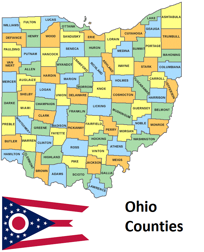
Ohio Counties. List Alphabetically (and by Population)
How many counties are there in Ohio? As of 2024, there are a total of 88 counties in the state of Ohio. Among them, Washington County is the oldest one (established in 1788) while Noble County is the youngest (established in 1851). With population of 1,264,518, Franklin County is the most populated. The biggest county by land area is Ashtabula County (1,819 km²) and the smallest is Lake County (591 km²).
Largest Counties in Ohio
1. Ashtabula County
County Seat: Jefferson
- Area: 1,368 square miles
- Population: 97,241 (as of 2020 census)
- Area Codes: 440
- Latitude: 41.8670° N
- Longitude: 80.7898° W
Location and History
Ashtabula County is located in the northeastern corner of Ohio, along the shores of Lake Erie. It was established in 1807 and is named after the Ashtabula River, with “Ashtabula” being derived from an Algonquin term meaning “river of many fish.” The county has a rich history tied to the Underground Railroad, with many safe houses in the area aiding enslaved people seeking freedom. Agriculture and manufacturing have traditionally been key components of the local economy, with the county’s location along Lake Erie facilitating trade and transport.
Major Highways and Landmarks
Interstate 90 runs east-west through Ashtabula County, providing a major transportation route. U.S. Route 20 also passes through the county. Ashtabula County is famous for its covered bridges, with 19 such structures, including the Smolen-Gulf Bridge, the longest covered bridge in the United States. Geneva-on-the-Lake, a historic resort town on Lake Erie, is a popular destination for visitors seeking recreation and entertainment. The county also features the Ashtabula Harbor, which played a significant role in the industrial shipping industry in the 19th and 20th centuries.
2. Licking County
County Seat: Newark
- Area: 687 square miles
- Population: 178,519 (as of 2020 census)
- Area Codes: 740, 220
- Latitude: 40.0581° N
- Longitude: 82.4013° W
Location and History
Licking County is located in central Ohio, just east of Columbus. It was established in 1808 and named after the Licking River, which flows through the county. The area has a rich history, with early Native American cultures, including the Hopewell and Adena, leaving behind significant earthworks and mounds. Licking County played a pivotal role in the early development of Ohio, with Newark becoming an important center for commerce and transportation in the 19th century.
Major Highways and Landmarks
Interstate 70 and U.S. Route 40 (the National Road) are major highways that pass through Licking County, making it a crucial link between eastern and western Ohio. The Newark Earthworks, a series of ancient geometric earthworks built by the Hopewell culture, are a major landmark and one of the most important archaeological sites in the state. Dawes Arboretum, located near Newark, is another significant landmark, offering beautiful gardens and natural areas for visitors. The county also features the historic village of Granville, known for its New England-style architecture and Denison University.
3. Trumbull County
County Seat: Warren
- Area: 625 square miles
- Population: 201,977 (as of 2020 census)
- Area Codes: 234, 330
- Latitude: 41.3065° N
- Longitude: 80.7658° W
Location and History
Trumbull County is located in northeastern Ohio, near the Pennsylvania border. It was established in 1800 and named after Jonathan Trumbull, a governor of Connecticut. The county has a rich industrial history, particularly in steel production, which contributed to the growth of cities like Warren and Youngstown. Trumbull County also has deep ties to the abolitionist movement, with several stops on the Underground Railroad located within its borders.
Major Highways and Landmarks
Interstate 80 and U.S. Route 422 are major highways that run through Trumbull County, providing critical connections to nearby cities like Cleveland and Pittsburgh. Mosquito Lake State Park, one of the largest lakes in Ohio, is a major recreational area offering boating, fishing, and camping. The Kinsman House in Warren, built in the 1830s, is a significant historic landmark that reflects the county’s early prosperity. Additionally, the Packard Music Hall, named after the Packard automobile family, is a cultural hub in Warren, hosting concerts and events.
4. Coshocton County
County Seat: Coshocton
- Area: 567 square miles
- Population: 36,612 (as of 2020 census)
- Area Codes: 740, 220
- Latitude: 40.2729° N
- Longitude: 81.8894° W
Location and History
Coshocton County is located in east-central Ohio, at the confluence of the Tuscarawas and Walhonding Rivers, forming the Muskingum River. It was established in 1810 and named after a Native American word meaning “union of waters.” The county has a rich history tied to early Native American settlements, with the Lenape (Delaware) people having a significant presence in the area. The town of Coshocton grew as a center for trade and industry, particularly with the advent of the Ohio and Erie Canal in the early 19th century.
Major Highways and Landmarks
U.S. Route 36 is the main highway that runs through Coshocton County, providing access to nearby regions. The county is known for its historic Roscoe Village, a restored 19th-century canal town that offers a glimpse into Ohio’s early transportation history. The Johnson-Humrickhouse Museum, located in Coshocton, features exhibits on local history, including Native American artifacts and pioneer life. The Warsaw Caves, a series of natural caves along the Walhonding River, are a popular destination for outdoor enthusiasts.
5. Geauga County
County Seat: Chardon
- Area: 408 square miles
- Population: 95,397 (as of 2020 census)
- Area Codes: 440
- Latitude: 41.5762° N
- Longitude: 81.2005° W
Location and History
Geauga County is located in northeastern Ohio, part of the Greater Cleveland metropolitan area. The county was established in 1806 and named after a Native American word meaning “raccoon.” Geauga County has a rich history of agriculture, with the Amish community playing a significant role in the county’s culture and economy. The county’s scenic landscapes, including rolling hills and dense forests, have made it a desirable place for both residents and visitors.
Major Highways and Landmarks
U.S. Route 6 and State Route 44 are major highways that provide access to Geauga County’s towns and natural areas. The county is famous for its Amish community, particularly in the Middlefield area, where visitors can experience traditional Amish crafts, foods, and lifestyle. The Geauga County Maple Festival, held annually in Chardon, celebrates the county’s long history of maple syrup production. Another significant landmark is the West Woods, a large nature preserve offering hiking trails and educational programs about the local ecosystem.
6. Harrison County
County Seat: Cadiz
- Area: 411 square miles
- Population: 14,477 (as of 2020 census)
- Area Codes: 740, 220
- Latitude: 40.2719° N
- Longitude: 81.0817° W
Location and History
Harrison County is located in eastern Ohio, within the Appalachian region. The county was established in 1813 and named after General William Henry Harrison, who later became the ninth President of the United States. The county has a strong agricultural heritage, with farming being a mainstay of the local economy for much of its history. Harrison County is also known for its historical ties to the oil and gas industry, which played a significant role in its development during the late 19th and early 20th centuries.
Major Highways and Landmarks
U.S. Route 22 is the primary highway that runs through Harrison County, connecting it to neighboring regions. The county is home to Tappan Lake, a large reservoir that offers recreational activities such as boating, fishing, and camping. Another major landmark is the Clark Gable Foundation and Museum in Cadiz, which honors the life and career of the legendary Hollywood actor who was born in the county. The Harrison Coal and Reclamation Historical Park showcases the region’s history of coal mining and reclamation efforts.
7. Medina County
County Seat: Medina
- Area: 423 square miles
- Population: 182,470 (as of 2020 census)
- Area Codes: 330, 234
- Latitude: 41.1353° N
- Longitude: 81.8562° W
Location and History
Medina County is located in northeastern Ohio, just south of Cleveland. It was established in 1812 and named after the ancient city of Medina in Saudi Arabia. The county has a rich agricultural history, with early settlers primarily engaging in farming and dairy production. Over time, Medina County has transformed into a suburban area, with significant population growth driven by its proximity to the Greater Cleveland metropolitan area.
Major Highways and Landmarks
Interstate 71 and U.S. Route 42 are major highways that run through Medina County, providing easy access to Cleveland and other nearby cities. Medina Square, the historic center of Medina, is known for its well-preserved 19th-century architecture and hosts various community events throughout the year. The county is also home to the Medina County Fair, one of the oldest and largest county fairs in Ohio. Another notable landmark is the Castle Noel, a unique museum in Medina that showcases Christmas movie memorabilia and holiday decorations from around the world.
8. Muskingum County
County Seat: Zanesville
- Area: 673 square miles
- Population: 86,410 (as of 2020 census)
- Area Codes: 740, 220
- Latitude: 39.9403° N
- Longitude: 82.0132° W
Location and History
Muskingum County is located in east-central Ohio, at the confluence of the Muskingum and Licking Rivers. The county was established in 1804 and named after the Muskingum River, with the name likely derived from a Native American word meaning “moose eye” or “elk’s eye.” Zanesville, the county seat, was once the state capital of Ohio and played a significant role in the early development of the state. The county has a rich industrial history, particularly in pottery and ceramics production.
Major Highways and Landmarks
Interstate 70 and U.S. Route 40 (the National Road) are major highways that pass through Muskingum County, providing important transportation links. The Y-Bridge in Zanesville, a unique three-way bridge, is one of the county’s most iconic landmarks and a symbol of the city. The Muskingum River Parkway, with its series of historic locks and dams, is a significant recreational and historical site. The county is also home to The Wilds, a large wildlife conservation center that offers safari-style tours and educational programs about endangered species.
9. Athens County
County Seat: Athens
- Area: 507 square miles
- Population: 62,431 (as of 2020 census)
- Area Codes: 740, 220
- Latitude: 39.3292° N
- Longitude: 82.1013° W
Location and History
Athens County is located in southeastern Ohio, in the Appalachian foothills. The county was established in 1805 and named after Athens, Greece, reflecting the settlers’ admiration for classical learning and culture. Athens is home to Ohio University, one of the oldest public universities in the United States, founded in 1804. The county has a rich history tied to education, coal mining, and the development of the Appalachian region.
Major Highways and Landmarks
U.S. Route 33 and State Route 13 are the main highways that run through Athens County, providing access to the city of Athens and surrounding areas. Ohio University, with its historic campus and vibrant student life, is the heart of Athens and a major cultural and economic force in the county. The county is also known for the Hocking Hills region, which offers stunning natural beauty, including waterfalls, caves, and hiking trails. The Athens Farmers Market is another notable landmark, known for its wide variety of local produce and crafts.
10. Wayne County
County Seat: Wooster
- Area: 557 square miles
- Population: 115,710 (as of 2020 census)
- Area Codes: 330, 234
- Latitude: 40.8082° N
- Longitude: 81.9535° W
Location and History
Wayne County is located in northeastern Ohio, between Cleveland and Columbus. The county was established in 1808 and named after General “Mad” Anthony Wayne, a Revolutionary War hero. The county has a strong agricultural heritage, with dairy farming, crop production, and livestock playing major roles in its economy. Over time, Wayne County has also developed as a center for education and research, particularly in agriculture.
Major Highways and Landmarks
U.S. Route 30 and State Route 83 are major highways that provide access to Wayne County and connect it to larger urban areas. The city of Wooster, home to the College of Wooster, is the cultural and educational center of the county. The Ohio Agricultural Research and Development Center (OARDC), affiliated with The Ohio State University, is a significant landmark, focusing on agricultural research and innovation. The Secrest Arboretum, part of the OARDC, offers beautiful gardens and walking trails. Wayne County is also known for its Amish community, particularly in the southeastern part of the county, where visitors can experience traditional Amish culture and craftsmanship.
List of All Counties in Ohio Alphabetically
Below please see all Ohio counties which are listed in alphabetical order.
- Adams County, OH
- Allen County, OH
- Ashland County, OH
- Ashtabula County, OH
- Athens County, OH
- Auglaize County, OH
- Belmont County, OH
- Brown County, OH
- Butler County, OH
- Carroll County, OH
- Champaign County, OH
- Clark County, OH
- Clermont County, OH
- Clinton County, OH
- Columbiana County, OH
- Coshocton County, OH
- Crawford County, OH
- Cuyahoga County, OH
- Darke County, OH
- Defiance County, OH
- Delaware County, OH
- Erie County, OH
- Fairfield County, OH
- Fayette County, OH
- Franklin County, OH
- Fulton County, OH
- Gallia County, OH
- Geauga County, OH
- Greene County, OH
- Guernsey County, OH
- Hamilton County, OH
- Hancock County, OH
- Hardin County, OH
- Harrison County, OH
- Henry County, OH
- Highland County, OH
- Hocking County, OH
- Holmes County, OH
- Huron County, OH
- Jackson County, OH
- Jefferson County, OH
- Knox County, OH
- Lake County, OH
- Lawrence County, OH
- Licking County, OH
- Logan County, OH
- Lorain County, OH
- Lucas County, OH
- Madison County, OH
- Mahoning County, OH
- Marion County, OH
- Medina County, OH
- Meigs County, OH
- Mercer County, OH
- Miami County, OH
- Monroe County, OH
- Montgomery County, OH
- Morgan County, OH
- Morrow County, OH
- Muskingum County, OH
- Noble County, OH
- Ottawa County, OH
- Paulding County, OH
- Perry County, OH
- Pickaway County, OH
- Pike County, OH
- Portage County, OH
- Preble County, OH
- Putnam County, OH
- Richland County, OH
- Ross County, OH
- Sandusky County, OH
- Scioto County, OH
- Seneca County, OH
- Shelby County, OH
- Stark County, OH
- Summit County, OH
- Trumbull County, OH
- Tuscarawas County, OH
- Union County, OH
- Van Wert County, OH
- Vinton County, OH
- Warren County, OH
- Washington County, OH
- Wayne County, OH
- Williams County, OH
- Wood County, OH
- Wyandot County, OH