New Jersey Counties. List Alphabetically (and by Population)

How many counties are there in New Jersey? As of 2024, there are a total of 21 counties in the state of New Jersey. Among them, Bergen County is the oldest one (established in 1683) while Union County is the youngest (established in 1857).  With population of 905,116, Bergen County is the most populated. The biggest county by land area is Burlington County (2,085 km²) and the smallest is Hudson County (122 km²).

Largest Counties in New Jersey

1. Burlington County

County Seat: Mount Holly

  • Area: 819 square miles
  • Population: Approximately 461,860
  • Area Codes: 609, 856
  • Latitude and Longitude: 39.9950° N, 74.7873° W

Location and History

Burlington County, located in the southwestern part of New Jersey, is the largest county by area in the state. Established in 1694, the county is one of the oldest in New Jersey, with a rich history that dates back to colonial times. The county seat, Mount Holly, is known for its well-preserved historic district and its role in the Revolutionary War. Burlington County’s location between Philadelphia and the Jersey Shore has historically made it a hub of transportation and commerce. The county’s diverse landscape includes suburban areas, farmland, and protected natural spaces, reflecting its evolution from an agricultural center to a suburban extension of the Philadelphia metropolitan area.

Major Highways and Landmarks

Burlington County is well-connected by major highways, including the New Jersey Turnpike (Interstate 95), which runs north-south through the county, and Interstate 295, which parallels the Turnpike and provides additional access to Philadelphia. U.S. Route 206 and U.S. Route 130 are also key routes within the county. Notable landmarks include the historic town of Burlington, one of the oldest settlements in New Jersey, and the Pine Barrens, a vast expanse of forest and wetlands that offers hiking, camping, and wildlife viewing opportunities. The county is also home to the Rancocas State Park, which provides outdoor recreation and preserves the natural beauty of the region. The Smithville Mansion, a historic site in Eastampton, reflects the county’s industrial past and is now a museum and cultural center.

2. Ocean County

County Seat: Toms River

  • Area: 636 square miles
  • Population: Approximately 637,229
  • Area Codes: 732, 848, 609
  • Latitude and Longitude: 39.9537° N, 74.1979° W

Location and History

Ocean County is located along the Jersey Shore in the central part of New Jersey. The county was established in 1850 and named for its coastal location along the Atlantic Ocean. Toms River, the county seat, is a historic town that played a role in both the American Revolution and the industrial development of New Jersey. Ocean County has grown rapidly over the past few decades, driven by its desirable location near the shore, which has made it a popular destination for both residents and tourists. The county’s economy is heavily influenced by tourism, particularly in the summer months when visitors flock to the beaches, boardwalks, and amusement parks.

Major Highways and Landmarks

Ocean County is served by major highways such as the Garden State Parkway, which runs north-south through the county, providing access to the Jersey Shore and the New York metropolitan area. U.S. Route 9 also runs through the county, paralleling the Parkway and providing an alternate route. Notable landmarks include Island Beach State Park, a preserved barrier island offering pristine beaches and natural habitats, and Six Flags Great Adventure, a large amusement park and safari located in Jackson. The county is also home to the Barnegat Lighthouse on Long Beach Island, a historic beacon that offers panoramic views of the coastline. Toms River’s downtown area hosts the annual New Jersey Chili and Salsa Cook-Off, attracting visitors with its blend of culinary competition and community festivities.

3. Atlantic County

County Seat: Mays Landing

  • Area: 671 square miles
  • Population: Approximately 263,670
  • Area Codes: 609
  • Latitude and Longitude: 39.4522° N, 74.7276° W

Location and History

Atlantic County is located in southeastern New Jersey, along the Atlantic coast. The county was established in 1837 and named for its proximity to the Atlantic Ocean. Mays Landing, the county seat, is a small town known for its historic sites and its location along the Great Egg Harbor River. Atlantic County is best known for Atlantic City, a major resort city that has been a popular destination since the late 19th century. The county’s economy is heavily reliant on tourism, with Atlantic City’s casinos, beaches, and boardwalks serving as major attractions. The inland areas of the county are more rural and are known for their cranberry bogs and blueberry farms.

Major Highways and Landmarks

Atlantic County is served by several major highways, including the Atlantic City Expressway, which connects the county to Philadelphia, and the Garden State Parkway, which runs north-south through the county. U.S. Route 30 and U.S. Route 40 also provide access to Atlantic City and other parts of the county. Notable landmarks include the Atlantic City Boardwalk, the oldest and longest boardwalk in the United States, and the Absecon Lighthouse, the tallest lighthouse in New Jersey. The county is also home to the Edwin B. Forsythe National Wildlife Refuge, which provides critical habitat for migratory birds and offers opportunities for birdwatching and nature walks. The historic town of Smithville offers a glimpse into the past with its restored village shops and seasonal festivals.

4. Cumberland County

County Seat: Bridgeton

  • Area: 677 square miles
  • Population: Approximately 150,972
  • Area Codes: 856
  • Latitude and Longitude: 39.3772° N, 75.0270° W

Location and History

Cumberland County is located in the southwestern part of New Jersey, bordered by the Delaware Bay to the south. The county was established in 1748 and named after the Duke of Cumberland, the son of King George II of Great Britain. Bridgeton, the county seat, is known for its historic downtown and as the site of one of the largest historic districts in New Jersey. Cumberland County has a rich agricultural history, particularly in glass manufacturing and farming, with the fertile land of the Delaware River Valley supporting a variety of crops. The county remains one of New Jersey’s leading agricultural producers, particularly in vegetables and fruits.

Major Highways and Landmarks

Cumberland County is accessible via major highways such as Route 55, which runs north-south and connects the county to Philadelphia, and Route 47, which runs through the center of the county. Notable landmarks include the Cohanzick Zoo in Bridgeton, New Jersey’s first zoo, and the nearby Bridgeton City Park, which offers a variety of recreational opportunities. The county is also home to the Maurice River, which is designated as a National Wild and Scenic River and is known for its natural beauty and opportunities for boating and fishing. The East Point Lighthouse, located on the Delaware Bay, is one of New Jersey’s oldest lighthouses and a popular spot for photography and birdwatching. Additionally, the Millville Army Air Field Museum preserves the history of the area’s role during World War II as a training base for fighter pilots.

5. Sussex County

County Seat: Newton

  • Area: 535 square miles
  • Population: Approximately 140,799
  • Area Codes: 973, 862
  • Latitude and Longitude: 41.1432° N, 74.7085° W

Location and History

Sussex County is located in the northwestern part of New Jersey, characterized by its mountainous terrain and rural landscapes. The county was established in 1753 and named after the historic county of Sussex in England. Newton, the county seat, is known for its historic courthouse and as a hub for the surrounding agricultural region. Sussex County has a long history tied to farming, mining, and iron production, with the area’s natural resources playing a significant role in its development. The county is part of the Skylands Region, known for its rolling hills, forests, and outdoor recreational opportunities.

Major Highways and Landmarks

Sussex County is served by major highways such as Route 23, which runs north-south through the county, and Route 206, which also provides north-south access. Interstate 80 runs just south of the county, providing access to the New York metropolitan area. Notable landmarks include High Point State Park, home to the highest elevation in New Jersey, and the High Point Monument, which offers panoramic views of three states. The county is also home to the Delaware Water Gap National Recreation Area, a popular destination for hiking, camping, and canoeing along the Delaware River. Sussex County’s agricultural heritage is celebrated at the annual New Jersey State Fair/Sussex County Farm and Horse Show, which draws visitors from across the state. The Sterling Hill Mining Museum in Ogdensburg provides a fascinating look into the area’s mining history and the unique fluorescent minerals found in the region.

6. Hunterdon County

County Seat: Flemington

  • Area: 429 square miles
  • Population: Approximately 124,371
  • Area Codes: 908
  • Latitude and Longitude: 40.5073° N, 74.8606° W

Location and History

Hunterdon County is located in western New Jersey, along the Delaware River. The county was established in 1714 and named after Robert Hunter, a colonial governor of New Jersey. Flemington, the county seat, is known for its historic downtown and as the site of the famous Lindbergh baby kidnapping trial in 1935. Hunterdon County has long been known for its rural character, with rolling hills, farmland, and charming small towns. The county’s economy has traditionally been based on agriculture, particularly dairy farming, though it has become more suburbanized in recent decades as people move away from the more densely populated areas of the state.

Major Highways and Landmarks

Hunterdon County is accessible via major highways such as Interstate 78, which runs east-west through the northern part of the county, and Route 31, which runs north-south. Route 202 also provides access to the county from the north and south. Notable landmarks include the Red Mill Museum Village in Clinton, a historic mill that now serves as a museum and cultural center. The Delaware and Raritan Canal State Park offers miles of trails along the historic canal, popular for hiking, biking, and canoeing. The county is also home to Round Valley Reservoir, one of the deepest lakes in New Jersey, which offers fishing, boating, and camping opportunities. Hunterdon County’s scenic beauty and historic charm make it a popular destination for weekend getaways from the New York City and Philadelphia metropolitan areas.

7. Warren County

County Seat: Belvidere

  • Area: 364 square miles
  • Population: Approximately 105,779
  • Area Codes: 908, 973
  • Latitude and Longitude: 40.8290° N, 75.0787° W

Location and History

Warren County is located in the northwestern part of New Jersey, along the Delaware River. The county was established in 1824 and named after General Joseph Warren, a hero of the Battle of Bunker Hill during the American Revolution. Belvidere, the county seat, is known for its Victorian architecture and as the site of the annual Warren County Farmers’ Fair. Warren County has a rich agricultural history, particularly in dairy farming and fruit orchards, and remains one of the more rural counties in New Jersey. The county’s location in the Kittatinny Valley and along the Appalachian Mountains gives it a rugged, scenic beauty that attracts outdoor enthusiasts.

Major Highways and Landmarks

Warren County is accessible via Interstate 80, which runs east-west through the northern part of the county, and U.S. Route 22, which runs east-west through the southern part of the county. Route 57 provides access to the central part of the county. Notable landmarks include the Delaware Water Gap National Recreation Area, a major destination for hiking, camping, and water sports along the Delaware River. The county is also home to the Appalachian Trail, which runs along the Kittatinny Ridge and offers stunning views of the surrounding countryside. The Land of Make Believe amusement park in Hope is a popular family destination, offering rides, water slides, and entertainment. The annual Warren County Farmers’ Fair, featuring hot air balloon launches, is a highlight of the summer and showcases the county’s agricultural heritage.

8. Morris County

County Seat: Morristown

  • Area: 481 square miles
  • Population: Approximately 492,694
  • Area Codes: 973, 862
  • Latitude and Longitude: 40.7979° N, 74.4815° W

Location and History

Morris County is located in northern New Jersey, about 25 miles west of New York City. The county was established in 1739 and named after Lewis Morris, the first governor of the Province of New Jersey. Morristown, the county seat, is known for its significant role in the American Revolution, particularly as the winter encampment for General George Washington and the Continental Army in 1777. Morris County is one of the most affluent and densely populated counties in New Jersey, with a diverse economy that includes finance, pharmaceuticals, and technology. The county’s historical significance, coupled with its proximity to New York City, has made it a desirable place to live and work.

Major Highways and Landmarks

Morris County is well-served by major highways, including Interstate 287, which runs north-south through the county, and Interstate 80, which runs east-west. U.S. Route 46 and New Jersey Route 10 are also major routes within the county. Notable landmarks include the Morristown National Historical Park, which preserves sites related to the American Revolution, including Washington’s Headquarters and Jockey Hollow. The county is also home to the Morris Museum, which features exhibits on art, science, and history, and the Frelinghuysen Arboretum, a public garden and educational center. The Great Swamp National Wildlife Refuge, located partially within the county, offers opportunities for birdwatching, hiking, and environmental education. The county’s rich history, coupled with its modern amenities, makes Morris County a vibrant and dynamic region.

9. Salem County

County Seat: Salem

  • Area: 338 square miles
  • Population: Approximately 62,607
  • Area Codes: 856
  • Latitude and Longitude: 39.5728° N, 75.4712° W

Location and History

Salem County is located in southwestern New Jersey, along the Delaware River and near the border with Delaware. The county was established in 1694 and is one of the oldest in New Jersey. Salem, the county seat, is known for its well-preserved historic district and as the site of the oldest active courthouse in the United States, dating back to 1735. Salem County has a rural character, with agriculture playing a significant role in the local economy, particularly in crops such as corn, soybeans, and vegetables. The county’s location along the Delaware River has historically made it an important transportation and trade hub.

Major Highways and Landmarks

Salem County is accessible via major highways such as Interstate 295, which runs along the eastern edge of the county, and U.S. Route 40, which runs east-west through the county. The New Jersey Turnpike also passes through the county, providing easy access to both the Philadelphia and New York metropolitan areas. Notable landmarks include the Hancock House in Hancock’s Bridge, a historic site of a Revolutionary War massacre, and Fort Mott State Park, which offers historical exhibits and views of the Delaware River. The county is also home to the Supawna Meadows National Wildlife Refuge, which provides habitat for migratory birds and other wildlife. The Cowtown Rodeo in Pilesgrove is a unique attraction, offering rodeo events throughout the summer and celebrating the county’s agricultural heritage.

10. Somerset County

County Seat: Somerville

  • Area: 305 square miles
  • Population: Approximately 331,164
  • Area Codes: 908
  • Latitude and Longitude: 40.5742° N, 74.6096° W

Location and History

Somerset County is located in central New Jersey, about 30 miles west of New York City. The county was established in 1688 and named after Somerset in England. Somerville, the county seat, is known for its historic downtown and as a center for government and commerce in the region. Somerset County has a diverse economy, with significant contributions from education, healthcare, finance, and manufacturing. The county’s location within the New York metropolitan area has made it a desirable place to live, with a mix of suburban communities, farmland, and preserved open spaces.

Major Highways and Landmarks

Somerset County is well-connected by major highways, including Interstate 287, which runs north-south through the county, and Interstate 78, which runs east-west. U.S. Route 22 and New Jersey Route 28 also provide access to key areas within the county. Notable landmarks include Duke Farms in Hillsborough, a large estate and environmental center with miles of trails and gardens open to the public. The county is also home to the United States Golf Association Museum in Far Hills, which preserves the history of golf in America. The Watchung Reservation, located partially within the county, offers hiking, horseback riding, and nature education. The annual Far Hills Race Meeting, known as “The Hunt,” is a major steeplechase event that draws visitors from across the region. Somerset County’s blend of historical sites, cultural institutions, and natural beauty makes it a vibrant and attractive place to live.

List of All Counties in New Jersey Alphabetically

Below please see all New Jersey counties which are listed in alphabetical order.

  1. Atlantic County, NJ
  2. Bergen County, NJ
  3. Burlington County, NJ
  4. Camden County, NJ
  5. Cape May County, NJ
  6. Cumberland County, NJ
  7. Essex County, NJ
  8. Gloucester County, NJ
  9. Hudson County, NJ
  10. Hunterdon County, NJ
  11. Mercer County, NJ
  12. Middlesex County, NJ
  13. Monmouth County, NJ
  14. Morris County, NJ
  15. Ocean County, NJ
  16. Passaic County, NJ
  17. Salem County, NJ
  18. Somerset County, NJ
  19. Sussex County, NJ
  20. Union County, NJ
  21. Warren County, NJ

Map of New Jersey Counties
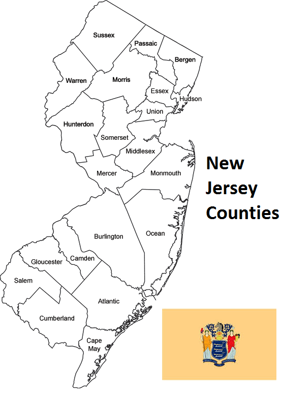
Map of New Jersey Counties