Malawi Facts
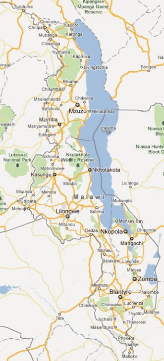
Malawi, Eastern African State; 118,000 km² (including 24 208 km² inland water), 18.1 million residents (2019).Malawi is located along the southernmost outlet of the East African rift system and borders Tanzania in the northeast, Mozambique in the east, south and west and Zambia in the west. The capital is Lilongwe (1.2 million residents, 2018).
Country facts
- Republic of Malaŵi / Republic of Malawi
- Country abbreviation: MW
- Area: 118 000 km²
- Population (2019): 18.1 million residents
- Capital: Lilongwe
- Main languages: English, (chi) chewa
- State: Republic
- Head of State and Head of Government: Peter Mutharika (President)
- Per capita GDP (2018): US $ 389
- GNI per capita (2018): US $ 360
- Coin unit: 1 kwacha = 100 tambala
- Currency code: MWK
- Country number (telephony): 265
- Internet domain name: mw
- Time difference compared to Sweden: +1
- National Day: July 6 (Independence Day, 1964)
Nature
- Land use: forest (39%), agricultural land (21%), other (40%)
- Highest mountain: Sapitwa (3,000 meters above sea level)
- Largest lake: Lake Malawi (31,000 km² )
Population
- Population density (2019): 153 residents per km²
- Natural population growth (2019): 2.8%; birthrate 35 ‰, deathrate 7 ‰
- Age structure (2019): 0-14 years (45%), 15-64 (52%), 65- (3%)
- Life expectancy (2019): men 60 years, women 66 years
- Infant mortality (2019): 43 per 1,000 live births
- Population forecast 2050: 37 million residents
- HDI (2017): 0.477 (place 171 of 188)
- Urbanization rate (2019): 17%
- Most populous cities (2018): Lilongwe (1.2 million residents), Blantyre (994,500)
Business
- Industry’s contribution to GDP (2017): agriculture (29%), industry (15%), service (56%)
- Exports (2017): US $ 1,420 million
- Main export products: tobacco, tea, sugar
- Main exporting countries: Zimbabwe, Mozambique, Belgium
- Imports (2017): US $ 2 312 million
- Main Import Products: Food, Oil Products, Manufacturing
- Main importing countries: South Africa, China, India
- Railway network (2014): 770 km
Geography of Malawi
Location and Boundaries
Malawi is a landlocked country located in southeastern Africa. It is bordered by Zambia to the north, Tanzania to the northeast, Mozambique to the south, southeast, and southwest, with Lake Malawi forming a significant portion of its eastern border. The country is roughly shaped like an elongated rectangle, stretching over 1,000 kilometers from north to south and about 500 kilometers across at its widest point.
Terrain and Landscape
Malawi’s terrain is varied, with highlands, plateaus, and low-lying areas. The Great Rift Valley runs through the country, contributing to its varied topography. The northern region of Malawi features mountainous landscapes with the Nyika Plateau, while the central and southern regions consist of fertile plateaus and rolling hills. The eastern side of the country, which is along Lake Malawi, is characterized by a more tropical landscape, with dense forests and relatively flat terrain.
The vast majority of Malawi’s land area is devoted to agriculture, with fertile soils found throughout much of the central and southern regions. Lake Malawi, the third-largest lake in Africa, dominates the eastern part of the country. It is not only vital for transport and fishing but also plays a key role in the climate and biodiversity of the region.
Major Natural Features
Lake Malawi is Malawi’s most prominent natural feature, extending for over 560 kilometers and hosting a rich diversity of fish species, including many endemic species, which make it a key environmental asset. The country also boasts several national parks and wildlife reserves, including Liwonde National Park and Kasungu National Park, which help protect its diverse ecosystems.
Climate of Malawi
Tropical Climate
Malawi enjoys a predominantly tropical climate, with distinct wet and dry seasons. The wet season generally spans from November to April, with the peak of rainfall occurring in December through March. During this time, the country experiences heavy rains, particularly in the highlands and along the lake.
The dry season, lasting from May to October, is marked by lower rainfall and cooler temperatures, with the hottest months occurring in October and November before the onset of the rains. The temperature ranges from cool in the highlands to warm in the lowlands, with average temperatures in the capital, Lilongwe, typically ranging from 18°C to 28°C.
Regional Climate Variations
The climate in Malawi varies based on the geographical region. The southern region, being closer to the tropics, tends to experience more intense heat and humidity, especially near the lake. In contrast, the central and northern regions are slightly cooler, particularly at higher altitudes. These climate variations influence agricultural practices, the lifestyle of the inhabitants, and the overall ecology of the country.
People of Malawi
Population and Demographics
Malawi has a population of approximately 21 million people (as of 2023). The population is predominantly rural, with a significant percentage of people living in villages and small towns. Urbanization is gradually increasing, with major cities such as Lilongwe (the capital), Blantyre (the economic hub), and Mzuzu experiencing growth.
The country has a young population, with a large proportion of people under the age of 25. The life expectancy is improving but still relatively low, mainly due to health challenges such as HIV/AIDS and malnutrition.
Ethnicity and Languages
Malawi is a multiethnic society with a diverse range of ethnic groups. The Chewa people are the largest ethnic group, followed by the Lomwe, Tumbuka, and Ngoni, among others. Smaller groups such as the Yao, Senga, and Nyanja also contribute to the country’s cultural diversity. Each ethnic group has its own language, although many people speak several languages, especially in areas of mixed ethnic populations.
The official language of Malawi is English, which is used in government, business, and education. However, Chichewa (also known as Chewa or Nyanja) is the most widely spoken indigenous language and serves as a lingua franca for communication across different ethnic groups.
Religion and Beliefs
Malawi is a predominantly Christian country, with around 80% of the population identifying as Christians, followed by smaller groups practicing Islam (about 13%) and indigenous African religions (approximately 7%). Christianity is widely practiced throughout the country, with Catholicism and Protestantism being the most common denominations. Islam is particularly prevalent in the southern and central regions of Malawi.
Economy of Malawi
Agriculture as the Backbone
Agriculture plays a critical role in the economy of Malawi, with a majority of the population engaged in subsistence farming. The country’s fertile land is suitable for the cultivation of a variety of crops. Tobacco is the largest export product, followed by tea, sugar, and coffee. Malawi is one of the world’s largest producers of tobacco, which accounts for a significant portion of its foreign exchange earnings.
Other important crops include maize, cassava, groundnuts, and rice, which are grown both for local consumption and export. The agricultural sector faces challenges such as reliance on rain-fed farming, vulnerability to droughts, and limited access to modern farming technology.
Industry and Manufacturing
While agriculture is the dominant sector, Malawi has also made strides in developing its industrial base. The manufacturing sector in Malawi is still relatively small, with industries focusing on processing agricultural products, including food, tobacco, and beverages. The textiles and garment industries are also important contributors to the economy, particularly in terms of employment.
Malawi has significant mineral resources, including uranium, coal, and rare earth elements. Mining, however, has yet to play a major role in the economy, with most of the country’s resources being underutilized.
Economic Challenges and Development
Malawi is classified as one of the world’s poorest countries, with high levels of poverty and a reliance on aid. Economic growth is often hampered by issues such as corruption, poor infrastructure, and a lack of investment in key sectors. The country’s economic vulnerability is further exacerbated by its dependence on agriculture, which is highly susceptible to climate change and external market fluctuations.
In recent years, Malawi has made efforts to diversify its economy, with improvements in sectors such as tourism, telecommunications, and small-scale manufacturing. Tourism has been growing due to the country’s natural beauty, including Lake Malawi and its national parks, which attract international visitors.
Government of Malawi
Political System and Structure
Malawi operates as a democratic republic with a multi-party system. The President of Malawi serves as both the head of state and the head of government. The President is elected by popular vote for a five-year term, with the possibility of re-election. The legislative branch is bicameral, consisting of the National Assembly and the Senate. The National Assembly is made up of 193 members, while the Senate has 67 members.
The judiciary in Malawi is independent and consists of the High Court, the Supreme Court of Appeal, and various lower courts. The legal system is based on a combination of English common law and traditional African law, with customary law playing a significant role in rural areas.
Local Government
Malawi is divided into 28 districts, each of which is administered by a district commissioner. The districts are further subdivided into smaller administrative units known as traditional authorities, headed by chiefs. Local governance is structured to promote decentralization, giving regional and local authorities more control over administrative functions, although the central government retains significant power.
Corruption and Governance Issues
Corruption has been a persistent issue in Malawi, with high levels of bribery and mismanagement within both public and private sectors. Efforts to combat corruption include the establishment of anti-corruption institutions such as the Anti-Corruption Bureau. Despite some progress, Malawi continues to face challenges in ensuring transparent governance.
Culture of Malawi
Traditional Art and Craft
Malawi has a rich cultural heritage, with its diverse ethnic groups contributing to a vibrant tapestry of traditions, music, dance, and art. Traditional crafts such as beadwork, wood carving, and weaving are highly valued, and local artisans create intricate designs that reflect the country’s cultural identity.
The Chewa people are particularly known for their rich traditions in mask-making and ritual dance. The Gule Wamkulu, a ceremonial dance performed by Chewa men wearing elaborate masks, is a UNESCO recognized cultural heritage.
Music and Dance
Music is a central part of Malawian culture, with different communities having their own distinctive styles of music. Traditional instruments such as drums, flutes, and stringed instruments like the mbira are commonly used. Gospel music, both traditional and contemporary, is also popular, reflecting the strong Christian influence in the country.
Dance plays a significant role in Malawian cultural expression. From traditional dances that celebrate harvests to those performed during initiation rites, dance is seen as a way to connect with ancestors and express community identity.
Festivals and Celebrations
Malawians celebrate various cultural festivals throughout the year. These festivals often include music, dance, and traditional rituals. Some of the most notable celebrations include the Chewa people’s Kulamba ceremony, which marks the beginning of the harvest season, and the Lake of Stars festival, an international music festival held on the shores of Lake Malawi that draws both local and international performers.
History of Malawi
Early History and Kingdoms
The history of Malawi dates back thousands of years, with evidence of early human settlement in the region. Ancient kingdoms such as the Maravi Kingdom dominated the area long before the arrival of European colonizers. The Maravi Kingdom, established around the 16th century, was a powerful political and trading entity that controlled much of the territory now known as Malawi.
Colonial Period
In the late 19th century, the British established a protectorate over Malawi, which was then known as Nyasaland. The colonial era was marked by exploitation, forced labor, and a lack of political rights for the native Malawian population. The British imposed taxes on the people, and the economy was restructured to benefit British interests, particularly in the cultivation of tobacco and tea.
Independence and Post-Colonial Period
Malawi gained independence from Britain on July 6, 1964, with Dr. Hastings Kamuzu Banda becoming the first president. Banda’s rule was characterized by authoritarian policies and a strong emphasis on nationalism and unity. His regime, however, was also marked by widespread repression, political suppression, and the use of the police and military to maintain power.
Banda’s government was overthrown in 1994 following the introduction of multi-party democracy. Since then, Malawi has struggled with economic and social issues, but it has made significant strides in democracy and human rights, with regular elections and peaceful transfers of power.
Modern Era
The modern history of Malawi has been shaped by efforts to overcome poverty and improve the lives of its citizens. Despite the challenges, the country has seen improvements in education, healthcare, and infrastructure, as well as a growing commitment to human rights and democratic governance. However, Malawi continues to face significant challenges in the areas of poverty reduction, economic diversification, and environmental sustainability.
Malawi Map