Turkmenistan Facts
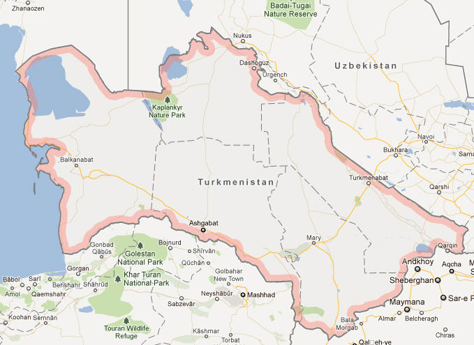
Turkmenistan, Central Asian State; 488,000 km², 5.8 million residents (2019).Turkmenistan borders north to Kazakhstan, north and east to Uzbekistan, southeast to Afghanistan, south to Iran and west to the Caspian Sea. The capital is Ashgabat (1 million residents, 2012).
Country facts
- Türkmenistan / Turkmenistan
- Country abbreviation: TM
- Area: 488 000 km²
- Population (2019): 5.8 million residents
- Capital: Ashgabat
- Main language: Turkmen
- State: Republic
- Head of State and Head of Government: Gurbanguli Berdimuchammedov
- Per capita GDP (2018): US $ 6,967
- GNI per capita (2018): US $ 6,740
- Currency unit: 1 month = 100 tenni
- Currency code: TMM
- Country number (telephony): 993
- Internet domain name: tm
- Time difference compared to Sweden: +4
- National Day: October 27 (Independence Day, 1991)
Nature
- Land use: forest (8%), agricultural land (3%), other (89%)
- Highest mountain: Ayribaba (2,942 m asl)
Population
- Population density (2019): 12 residents per km²
- Natural population growth (2019): 1.7%; birth rate 24 ‰, death rate 7 ‰
- Age structure (2019): 0-14 years (31%), 15-64 (65%), 65- (4%)
- Life expectancy (2019): men 64 years, women 71 years
- Infant mortality (2019): 44 per 1,000 live births
- Population forecast 2050: 8 million residents
- HDI (2017): 0.706 (place 108 of 189)
- Urbanization rate (2019): 52%
- Most populous cities (2012): Ashgabat (1 million residents), Chardzhou (408,900), Tasjauz (275,300)
Business
- Industry’s contribution to GDP (2017): agriculture (8%), industry (45%), service (47%)
- Exports (2017): US $ 7,458 million
- Main export products: natural gas, crude oil, cotton
- Main exporting countries: China, Turkey
- Imports (2017): US $ 7,571 million
- Main import products: machinery, chemicals, food
- Main importing countries: Turkey, Algeria, Germany
- Railway network (2014): 3,000 km
Geography of Turkmenistan
Location
Turkmenistan is a landlocked country in Central Asia, bordered by Kazakhstan to the northwest, Uzbekistan to the north and east, Afghanistan to the southeast, and Iran to the south. To the west, it has a coastline along the Caspian Sea. The country’s location places it at the crossroads of several ancient civilizations, which have influenced its culture and history. With a land area of approximately 491,210 square kilometers (189,660 square miles), Turkmenistan is the second-largest country in Central Asia by land area.
The capital of Turkmenistan is Ashgabat, located in the southern part of the country, near the border with Iran. The capital is an important cultural and political center, and it also serves as the main hub for economic activity. Despite its strategic location, Turkmenistan remains largely isolated from global trade routes due to its landlocked nature and political climate.
Topography
Turkmenistan’s landscape is dominated by vast deserts, particularly the Karakum Desert, which spans much of the country’s central and northern regions. This desert environment is marked by sand dunes, salt flats, and rugged terrain, with little vegetation due to the arid conditions. The Karakum Desert is one of the most expansive desert regions in Central Asia and plays a major role in defining the country’s geographical character.
In addition to the desert, Turkmenistan features mountain ranges, particularly in the south and southeast, where the Kopet Dag Mountains rise along the border with Iran. These mountains provide a contrast to the flat desert and are home to some of the highest elevations in Turkmenistan, with Mount Rizeh reaching 2,940 meters (9,646 feet) above sea level. These mountain ranges influence the climate and agriculture in the southern regions, offering areas of higher rainfall and fertile valleys, especially in the foothills.
Natural Resources
Turkmenistan is rich in natural resources, particularly natural gas, which is a major source of revenue for the country. Turkmenistan holds one of the largest reserves of natural gas in the world, particularly in the Galkynysh Gas Field, one of the largest in the world. This resource has allowed the country to develop significant energy exports, especially to neighboring countries such as China and Russia.
In addition to natural gas, Turkmenistan also has reserves of oil, although these are less extensive. The country is also rich in minerals, including sulfur, salt, and phosphates, which are extracted and used in the chemical industry. Agriculture, though less important than energy, is another key part of the economy. Cotton is the primary agricultural product, with Turkmenistan being one of the top producers of cotton in the world, though the country also grows wheat, vegetables, and fruits in irrigated regions.
Climate of Turkmenistan
General Climate
Turkmenistan experiences a harsh continental climate with hot summers and mild winters. Due to its landlocked position and the dominance of deserts, the country has a significant temperature range, with summer temperatures regularly exceeding 40°C (104°F) in many areas, particularly in the desert regions. Winter temperatures are more moderate, particularly in the mountainous regions, but can still drop to freezing levels at night, especially in the desert and foothill areas.
The climate varies by region. The coastal area along the Caspian Sea is milder, benefiting from the influence of the sea, which moderates temperature extremes. The southern and southeastern regions, particularly near the Iranian and Afghan borders, experience higher humidity and warmer temperatures. The central and northern areas, dominated by the Karakum Desert, see extreme heat in the summer months, with very little rainfall.
Rainfall and Seasonal Variations
Rainfall in Turkmenistan is sparse and highly irregular. The majority of the country, especially the Karakum Desert, receives very little precipitation, typically less than 100 millimeters (4 inches) annually. The majority of rainfall occurs in the winter and spring months, with the summer being dry, particularly in the desert. The rainfall is more abundant in the mountain regions, which receive more precipitation, and in the foothills where agriculture is practiced.
The seasonal variations are distinct, with the summer months being extremely hot, particularly in the desert and lowland areas, while the winter months are relatively mild, although nighttime temperatures can be quite cold. The dry and hot conditions of the summer contribute to water scarcity in many parts of the country, and irrigation is essential for agriculture, particularly in the cotton-growing regions.
People of Turkmenistan
Population and Ethnic Composition
Turkmenistan has a population of approximately 6 million people, with the majority of the population being ethnic Turkmen, making up around 85% of the population. The Turkmen people are part of the larger Turkic ethnic group, and their language, Turkmen, is a member of the Turkic language family. Ethnic Turkmen have historically been a nomadic people, and traditional customs and cultural practices continue to play an important role in daily life.
There are also smaller ethnic minorities in Turkmenistan, including Uzbeks, Russians, Kazakhs, and Armenians, though these groups make up a small percentage of the population. The country’s political and social structure is strongly centered around the ethnic Turkmen majority, and the government’s policies and national identity are focused on Turkmen traditions and values.
Urbanization in Turkmenistan is relatively low, with most of the population living in rural areas. However, Ashgabat, the capital city, is home to a significant portion of the population and serves as the cultural and economic center of the country. The capital is a modern city with wide avenues, government buildings, and large residential complexes, reflecting the country’s development and growth in recent years.
Language
Turkmen is the official language of Turkmenistan and is spoken by the majority of the population. It is part of the Turkic language family and has been influenced by Persian and Russian due to the country’s historical ties with Iran and Russia. The language is written in the Latin alphabet, which was adopted in 1993, replacing the Cyrillic script that had been used during the Soviet era. Turkmen is the language of instruction in schools and is widely used in government and media.
Russian is still spoken by a small minority, particularly among older generations and the Russian-speaking population, though it is no longer an official language. Russian was the dominant language during the Soviet period, and many people, especially in urban areas, are bilingual in Turkmen and Russian. Other languages spoken in Turkmenistan include Uzbek, Kazakh, and smaller minority languages.
Religion
Islam is the dominant religion in Turkmenistan, with the majority of the population being Muslim. Most Turkmen Muslims follow the Sunni branch of Islam, though there are smaller numbers of Shiite Muslims, particularly among the ethnic minorities. Islam was introduced to Turkmenistan during the 7th century, and over the centuries, it has become deeply embedded in the country’s culture and identity.
While Islam plays a central role in Turkmen society, the government of Turkmenistan tightly controls religious practice. The state promotes a secular image and discourages religious extremism. The government places restrictions on religious groups, including limiting the activities of religious organizations and controlling the number of mosques and religious gatherings. Despite these restrictions, many Turkmen still practice Islam privately, and religious holidays such as Ramadan and Eid al-Fitr are widely observed.
Economy of Turkmenistan
Economic Structure
Turkmenistan has a mixed economy, with the energy sector being the most important and the primary driver of economic growth. The country’s vast natural gas reserves are the foundation of its economy, and the energy sector accounts for a significant portion of its GDP, government revenue, and exports. Turkmenistan also exports oil, cotton, and textiles, and the country has developed a limited manufacturing sector focused primarily on processing raw materials.
The agricultural sector remains vital to the country, with cotton being the most important crop. Turkmenistan is one of the world’s largest producers of cotton, although this has been controversial due to the environmental impact of cotton farming, which relies heavily on irrigation. Other agricultural products include wheat, vegetables, fruits, and livestock, but the sector is hampered by water scarcity and a reliance on irrigation from the Amu Darya River.
The service sector is still underdeveloped, and the country has not yet fully capitalized on the potential of industries such as telecommunications, tourism, and financial services. However, the Turkmen government has begun to implement economic reforms to diversify the economy, including efforts to attract foreign investment and expand the private sector.
Energy and Industry
The energy sector is the cornerstone of Turkmenistan’s economy, and the country is one of the largest producers of natural gas in the world, with vast reserves in the Galkynysh field. Gas is the primary export of Turkmenistan, and the country has significant agreements in place with China, Russia, and other countries to export natural gas. Turkmenistan also has oil reserves, but they are less extensive compared to its natural gas resources. The oil industry is important for local energy consumption and exports.
The government has worked to develop its petrochemical industry, producing fertilizers, plastics, and other chemical products. The textile industry, based on cotton production, is another key part of the economy, with cotton processing mills and garment production facilities providing both local employment and exports. The country also has some mining activity, particularly the extraction of salt, sulfur, and other minerals, although these industries are not as developed as the energy sector.
Turkmenistan’s industrial base is expanding, though it remains reliant on state-run enterprises, and the country’s overall industrial development lags behind other Central Asian nations. The government has undertaken various initiatives to modernize infrastructure, such as the construction of new highways, airports, and rail links, to attract foreign investment and stimulate economic growth.
Trade and Agriculture
Trade plays an important role in the Turkmen economy, with the country’s primary trading partners being China, Russia, and other Central Asian countries. The export of natural gas is the country’s most important source of foreign exchange, while cotton remains a key agricultural export, despite environmental concerns. Turkmenistan also exports textiles, food products, and raw materials to neighboring countries and beyond.
Agriculture remains a significant part of the economy, with cotton being the most important crop, although the government has started diversifying agriculture in recent years to focus on wheat production and other food crops. The country’s reliance on irrigation, particularly from the Amu Darya River, poses challenges, as water scarcity and environmental degradation impact agricultural yields.
Despite Turkmenistan’s wealth in natural resources, its small, highly centralized economy remains vulnerable to fluctuations in global commodity prices. Efforts to diversify the economy, particularly by developing sectors such as textiles, manufacturing, and tourism, are ongoing, though these industries face challenges due to limited infrastructure and access to global markets.
Government of Turkmenistan
Political System
Turkmenistan is a one-party state with an authoritarian government. The country’s political system is dominated by the President, who holds extensive powers over all branches of government. The President is both the head of state and government, and the country’s constitution grants the President significant control over the executive, legislative, and judicial branches. The President is elected through a highly controlled process, and opposition parties are not permitted to participate in elections. The current President, Gurbanguly Berdimuhamedow, has been in power since 2007, following the death of his predecessor, Saparmurat Niyazov, who ruled the country with an iron fist for over two decades.
The government is characterized by tight control over the media, with no independent press, and extensive censorship of information. Political opposition is not tolerated, and human rights groups have raised concerns about the lack of political freedoms, the suppression of dissent, and the detention of political prisoners. The country operates under a personality cult, with the President being portrayed as a figure of authority and national pride.
The legislative body in Turkmenistan is the Assembly of Turkmenistan, a unicameral parliament with members appointed by the President. While the Assembly is nominally responsible for creating laws, its function is largely ceremonial, and all significant decisions are made by the President and the executive branch.
Political History
Turkmenistan was part of the Soviet Union until its independence in 1991, when it became a republic within the former USSR. After independence, Saparmurat Niyazov became the country’s first President and established an authoritarian regime, emphasizing Turkmen nationalism and a cult of personality. Niyazov ruled with absolute power, banning political opposition and enforcing strict control over all aspects of society, including religion and culture. His regime was characterized by lavish state projects, such as the construction of monumental buildings and the publication of his own book, which became a quasi-religious text.
Following Niyazov’s death in 2007, Gurbanguly Berdimuhamedow ascended to power and continued many of the policies of his predecessor, though he has presented himself as a more reform-oriented leader. However, the country remains under strict authoritarian rule, and political freedoms are severely limited.
Governance Challenges
Turkmenistan faces numerous governance challenges, including a lack of political freedoms, human rights abuses, and widespread corruption. The country’s heavy dependence on its natural gas exports makes it vulnerable to fluctuations in global energy prices, and its isolated geopolitical position limits its ability to engage fully with the international community. Despite the country’s wealth in natural resources, Turkmenistan’s economy remains underdeveloped, and the population faces significant challenges in terms of access to healthcare, education, and employment opportunities.
The country’s political and economic future will depend on how well it can diversify its economy, improve infrastructure, and address its governance issues, all while managing the risks posed by climate change and its dependence on natural resources.
Culture of Turkmenistan
Traditional Music and Dance
Traditional music and dance play an important role in Turkmen culture, with a rich history that reflects the country’s nomadic heritage. Music is integral to daily life, celebrations, and social gatherings. The dutar, a two-stringed instrument, is a key feature of Turkmen music, and it is often used to accompany songs and poems. Traditional melodies and rhythms are passed down from generation to generation, and the music often reflects themes of love, heroism, and nature.
Turkmen dance, characterized by graceful movements and intricate footwork, is typically performed during weddings, holidays, and other social occasions. The dances are often highly symbolic, representing the community’s connection to the land, family, and culture.
Art and Craft
Turkmenistan has a rich tradition of handicrafts, particularly textiles, carpets, and embroidery. Turkmen carpets are world-renowned for their intricate designs and high quality. The craftsmanship of Turkmen carpet makers, known for their geometric patterns and bright colors, is a central part of the country’s artistic heritage. These carpets are woven by hand and are considered valuable cultural treasures.
In addition to carpets, Turkmen artisans also specialize in metalwork, pottery, and leather goods. These crafts are not only important for their artistic value but also have practical uses, with many items being used in daily life or during ceremonial events. The country’s art reflects its nomadic traditions and strong connection to the land.
Cuisine
Turkmen cuisine is a blend of Central Asian, Middle Eastern, and Persian influences. Traditional dishes are often based on lamb, beef, and chicken, which are prepared in stews, soups, and grilled forms. Pilaf (plov), a rice dish with meat and vegetables, is a staple of Turkmen cuisine and is often served at celebrations and gatherings.
Bread, particularly pita and flatbread, is an essential part of the diet, and it is typically baked in clay ovens. Other popular dishes include kebabs, samsa (savory pastries), and manty (steamed dumplings). Turkmen cuisine also includes a variety of dairy products, such as kymyz, a fermented drink made from mare’s milk.
Festivals and Celebrations
Turkmenistan celebrates several holidays and festivals, many of which are tied to the country’s Islamic heritage and the changing of the seasons. Nowruz, the Persian New Year, is one of the most important celebrations in Turkmenistan, marking the beginning of spring and the renewal of life. The festival is celebrated with music, dancing, feasts, and the cleaning of homes, symbolizing the rejection of the old and the welcoming of the new.
Other national holidays include Independence Day, which marks the country’s independence from the Soviet Union in 1991, and Turkmenistan Day, a celebration of the country’s culture and history. Festivals and celebrations often include traditional music, dance, and food, reflecting the country’s rich cultural heritage.
Turkmenistan Map