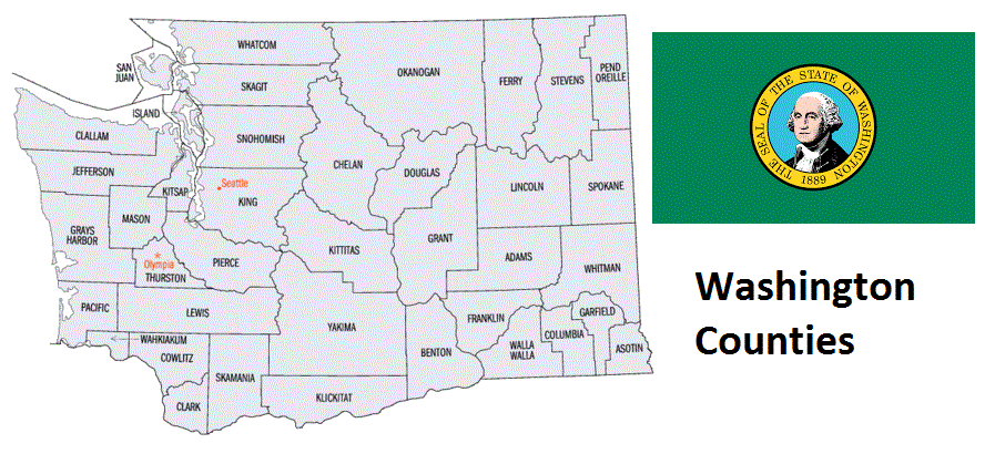
Washington Counties. List Alphabetically (and by Population)
How many counties are there in Washington? As of 2024, there are a total of 39 counties in the state of Washington. Among them, Clark County is the oldest one (established in 1845) while Pend Oreille County is the youngest (established in 1911). With population of 1,931,249, King County is the most populated. The biggest county by land area is Okanogan County (13,644 km²) and the smallest is San Juan County (453 km²).
Largest Counties in Washington
1. Okanogan County
County Overview
- County Seat: Okanogan
- Area: 5,315 square miles
- Population: 42,104 (2020 Census)
- Area Codes: 509
- Latitude: 48.3619° N
- Longitude: 119.6504° W
Location and History
Okanogan County, located in north-central Washington, is the largest county in the state by area. Established in 1888, the county’s name is derived from the Okanogan River, which itself is named after the Syilx people who inhabited the region. The county’s seat, Okanogan, serves as a hub for the surrounding agricultural and ranching communities. The area’s history is rich with Native American heritage, followed by a wave of European settlers drawn by the promise of fertile land and the gold rushes of the late 19th century. The construction of the Grand Coulee Dam in the 1930s further shaped the county’s economy, bringing electricity and irrigation to the region, transforming it into an agricultural powerhouse.
Major Highways and Landmarks
U.S. Route 97 is the major highway that runs north-south through Okanogan County, connecting it to Canada and the rest of Washington State. Another key route is Washington State Route 20, which crosses the county east to west, providing scenic views of the North Cascades. Major landmarks include the Okanogan-Wenatchee National Forest, offering vast wilderness areas for outdoor recreation. The Conconully State Park and Lake, located near the town of Conconully, is a popular destination for fishing, camping, and hiking. Additionally, the county is home to the Colville Indian Reservation, which preserves the culture and traditions of the indigenous people of the region.
2. Yakima County
County Overview
- County Seat: Yakima
- Area: 4,311 square miles
- Population: 256,728 (2020 Census)
- Area Codes: 509
- Latitude: 46.6021° N
- Longitude: 120.5059° W
Location and History
Yakima County is situated in south-central Washington and is known for its fertile agricultural lands, particularly for the production of apples, hops, and wine grapes. The county was established in 1865, and its name is derived from the Yakama Nation, whose reservation is located within the county. Yakima, the county seat, developed rapidly with the arrival of the Northern Pacific Railroad in the late 19th century, becoming a key transportation and agricultural hub. The county’s history is marked by the transformation of its arid lands into productive farmland through irrigation projects, which have made Yakima one of the leading agricultural regions in the United States.
Major Highways and Landmarks
Interstate 82 is the primary highway that runs through Yakima County, connecting it to the Tri-Cities area and beyond. U.S. Route 97 also serves the county, providing access to the Cascade Mountains and central Washington. Major landmarks in Yakima County include the Yakima Valley, renowned for its vineyards and wineries, contributing to Washington State’s reputation as a major wine-producing region. The Yakima Canyon, with its rugged cliffs and scenic views, is a popular destination for fishing, rafting, and hiking. Additionally, the Yakima Area Arboretum offers a peaceful retreat with its extensive gardens and natural areas, highlighting the diverse flora of the region.
3. Chelan County
County Overview
- County Seat: Wenatchee
- Area: 2,994 square miles
- Population: 79,074 (2020 Census)
- Area Codes: 509
- Latitude: 47.6730° N
- Longitude: 120.6766° W
Location and History
Chelan County, located in central Washington, is known for its stunning natural landscapes, including the Cascade Mountains and Lake Chelan. Established in 1899, the county’s name comes from a Salish word meaning “deep water,” referring to Lake Chelan, the third-deepest lake in the United States. Wenatchee, the county seat, is known as the “Apple Capital of the World” due to its significant role in apple production. The county’s history is intertwined with the development of agriculture, particularly fruit orchards, which thrived thanks to the area’s favorable climate and irrigation projects. The construction of dams along the Columbia River, such as the Rocky Reach Dam, further boosted the county’s economy by providing hydroelectric power and enhancing irrigation.
Major Highways and Landmarks
U.S. Route 2 and U.S. Route 97 are the main highways that serve Chelan County, offering connections to the Seattle area and central Washington. Major landmarks include Lake Chelan, a popular destination for boating, fishing, and water sports, surrounded by the charming town of Chelan. The Cascade Loop, a scenic byway that traverses the county, offers breathtaking views of the North Cascades and the Columbia River. The Leavenworth area, known for its Bavarian-style village, is another key attraction, drawing visitors year-round for its festivals, outdoor recreation, and alpine scenery. Additionally, the Wenatchee National Forest provides extensive opportunities for hiking, camping, and wildlife observation.
4. Grant County
County Overview
- County Seat: Ephrata
- Area: 2,791 square miles
- Population: 99,123 (2020 Census)
- Area Codes: 509
- Latitude: 47.3173° N
- Longitude: 119.5537° W
Location and History
Grant County, located in central Washington, was established in 1909 and named after Ulysses S. Grant, the 18th President of the United States. The county’s seat, Ephrata, serves as the administrative and commercial center of the region. Grant County’s history is closely tied to the Columbia Basin Project, a massive irrigation project that transformed the arid landscape into one of the most productive agricultural regions in the state. The construction of the Grand Coulee Dam, the largest concrete structure in the United States, was a key part of this project, providing water for irrigation, hydroelectric power, and flood control. The county is now a leading producer of potatoes, corn, wheat, and other crops.
Major Highways and Landmarks
Interstate 90 and U.S. Route 2 are the major highways that traverse Grant County, providing vital connections to Seattle and Spokane. Major landmarks include the Grand Coulee Dam, a marvel of modern engineering and a popular tourist destination, offering tours and a nightly laser light show. The Columbia National Wildlife Refuge, located in the southern part of the county, is a haven for birdwatchers and nature enthusiasts, featuring wetlands, lakes, and diverse wildlife. The county is also home to the Gorge Amphitheatre, a world-renowned outdoor concert venue perched above the Columbia River, attracting music lovers from across the country.
5. Stevens County
County Overview
- County Seat: Colville
- Area: 2,541 square miles
- Population: 46,445 (2020 Census)
- Area Codes: 509
- Latitude: 48.5445° N
- Longitude: 117.9056° W
Location and History
Stevens County, located in northeastern Washington, was established in 1863 and named after Isaac Stevens, the first governor of Washington Territory. The county seat, Colville, has a rich history as a fur trading post established by the Hudson’s Bay Company in the early 19th century. The county’s history is marked by the early settlement of the region by European traders and missionaries, followed by the development of mining, logging, and agriculture. The area’s natural resources, including timber and minerals, played a significant role in the county’s economic development. Today, Stevens County is known for its scenic beauty, outdoor recreation opportunities, and historical sites.
Major Highways and Landmarks
U.S. Route 395 is the primary highway running through Stevens County, connecting it to Spokane and the Canadian border. Major landmarks include the Colville National Forest, which offers a vast expanse of wilderness for hiking, camping, and fishing. The Little Pend Oreille National Wildlife Refuge, located in the eastern part of the county, is a unique area of wetlands, forests, and meadows, providing habitat for a variety of wildlife species. The county is also home to Lake Roosevelt, a large reservoir on the Columbia River created by the Grand Coulee Dam, which offers boating, fishing, and camping opportunities. The historic St. Paul’s Mission, established in 1847, is another notable landmark, reflecting the county’s early missionary history.
6. Ferry County
County Overview
- County Seat: Republic
- Area: 2,257 square miles
- Population: 7,178 (2020 Census)
- Area Codes: 509
- Latitude: 48.4786° N
- Longitude: 118.5882° W
Location and History
Ferry County, located in northeastern Washington, was established in 1899 and named after Elisha P. Ferry, the first governor of Washington State. The county seat, Republic, was founded during a gold rush in the late 19th century and remains a small but vibrant community. Ferry County’s history is shaped by its mining heritage, with gold, silver, and other minerals being extracted from the region’s mountains and valleys. The county’s remote location and rugged terrain have preserved much of its natural beauty, making it a destination for outdoor enthusiasts. Despite its small population, Ferry County has a rich cultural history, with the Colville Confederated Tribes playing a significant role in the area.
Major Highways and Landmarks
State Route 20 is the primary highway that runs through Ferry County, providing access to the North Cascades and the Okanogan Highlands. Major landmarks include the Kettle River Range, a mountain range known for its scenic beauty and opportunities for hiking, hunting, and wildlife observation. Curlew Lake State Park, located near Republic, is a popular spot for fishing, boating, and camping, offering stunning views of the surrounding landscape. The Stonerose Interpretive Center and Fossil Site in Republic is another key attraction, where visitors can explore the region’s ancient history and even dig for fossils themselves.
7. Whitman County
County Overview
- County Seat: Colfax
- Area: 2,159 square miles
- Population: 47,973 (2020 Census)
- Area Codes: 509
- Latitude: 46.9702° N
- Longitude: 117.3678° W
Location and History
Whitman County is located in southeastern Washington and is named after Marcus Whitman, a missionary and early settler in the region. The county was established in 1871 and is known for its rich agricultural lands, particularly for the production of wheat, barley, and legumes. The county seat, Colfax, is a small town that serves as the administrative and commercial center of the region. The history of Whitman County is closely tied to the development of agriculture, with the rolling hills of the Palouse region providing some of the most fertile farmland in the world. The county is also home to Washington State University, located in Pullman, which has had a significant impact on the area’s economy and culture.
Major Highways and Landmarks
U.S. Route 195 and State Route 26 are the primary highways that serve Whitman County, providing connections to Spokane, the Tri-Cities, and other parts of Washington. Major landmarks include the Palouse Falls State Park, home to the 198-foot Palouse Falls, a stunning natural wonder that draws visitors from across the state. The Kamiak Butte County Park, with its hiking trails and panoramic views of the Palouse region, is another popular destination for outdoor enthusiasts. The Washington State University campus in Pullman is a major landmark, offering a wide range of cultural, educational, and athletic events, as well as beautiful gardens and historic buildings.
8. Adams County
County Overview
- County Seat: Ritzville
- Area: 1,930 square miles
- Population: 20,613 (2020 Census)
- Area Codes: 509
- Latitude: 46.9820° N
- Longitude: 118.5267° W
Location and History
Adams County, located in southeastern Washington, was established in 1883 and named after John Adams, the second President of the United States. The county seat, Ritzville, developed as a key stop along the Northern Pacific Railroad, serving the agricultural needs of the region. The county’s history is deeply rooted in agriculture, particularly wheat farming, which remains the backbone of the local economy. The introduction of irrigation systems in the 20th century transformed parts of the arid landscape into productive farmland, allowing for the cultivation of a wider variety of crops. Today, Adams County continues to be one of the leading agricultural producers in Washington State.
Major Highways and Landmarks
Interstate 90 and U.S. Route 395 are the major highways that traverse Adams County, providing essential links to Spokane, Seattle, and other major cities. Major landmarks include the Ritzville Historic District, which preserves the town’s early 20th-century architecture and offers a glimpse into the county’s past. The Palouse to Cascades State Park Trail, a rail-trail that crosses the county, is a popular destination for biking, hiking, and horseback riding, offering scenic views of the rural landscape. Additionally, the Columbia National Wildlife Refuge, located in the southern part of the county, provides critical habitat for migratory birds and other wildlife, making it a haven for nature lovers and birdwatchers.
9. Kittitas County
County Overview
- County Seat: Ellensburg
- Area: 2,297 square miles
- Population: 44,337 (2020 Census)
- Area Codes: 509
- Latitude: 47.2330° N
- Longitude: 120.6747° W
Location and History
Kittitas County is located in central Washington and was established in 1883. The county’s name is derived from a Native American word, believed to mean “grassy place” or “meeting place.” Ellensburg, the county seat, is known for its historic downtown and as the home of Central Washington University. The county’s history is closely linked to the development of agriculture and livestock ranching, with the fertile Kittitas Valley serving as a major agricultural area. The construction of the Yakima River Canal and other irrigation projects in the early 20th century further boosted agricultural production in the region. Today, Kittitas County is known for its outdoor recreation opportunities and vibrant cultural scene.
Major Highways and Landmarks
Interstate 90 is the primary highway that runs through Kittitas County, providing a critical east-west route across Washington State. U.S. Route 97 also serves the county, connecting it to central Washington and the Yakima Valley. Major landmarks include the Ellensburg Rodeo, one of the oldest and most prestigious rodeos in the country, held annually over Labor Day weekend. The Ginkgo Petrified Forest State Park, located near the town of Vantage, is another key attraction, featuring one of the world’s most diverse petrified forests and stunning views of the Columbia River. The Yakima River Canyon, with its steep cliffs and scenic vistas, is a popular destination for fishing, rafting, and wildlife observation.
10. King County
County Overview
- County Seat: Seattle
- Area: 2,307 square miles
- Population: 2,269,675 (2020 Census)
- Area Codes: 206, 253, 425
- Latitude: 47.6062° N
- Longitude: 122.3321° W
Location and History
King County is located in western Washington and is the most populous county in the state, home to Seattle, the largest city in the Pacific Northwest. The county was established in 1852 and was originally named after William Rufus King, the Vice President of the United States at the time. In 1986, the county was officially renamed to honor Dr. Martin Luther King Jr., reflecting its commitment to civil rights and social justice. King County’s history is closely tied to the development of Seattle as a major port, commercial center, and technology hub. The region’s economy has been driven by industries such as logging, shipbuilding, aerospace, and, more recently, technology, with companies like Microsoft and Amazon headquartered in the county.
Major Highways and Landmarks
Interstate 5, Interstate 90, and Interstate 405 are the major highways that serve King County, connecting it to the rest of Washington and the broader Pacific Northwest region. Major landmarks in King County include the iconic Space Needle, a symbol of Seattle and a must-visit attraction for tourists. The Pike Place Market, one of the oldest continuously operating farmers’ markets in the United States, is another major draw, offering a vibrant mix of vendors, shops, and eateries. The county is also home to the Museum of Pop Culture, the Seattle Art Museum, and numerous parks and natural areas, including Discovery Park and the Snoqualmie Falls, making it a cultural and recreational hub of the region.
List of All Counties in Washington Alphabetically
Below please see all Washington counties which are listed in alphabetical order.
- Adams County, WA
- Asotin County, WA
- Benton County, WA
- Chelan County, WA
- Clallam County, WA
- Clark County, WA
- Columbia County, WA
- Cowlitz County, WA
- Douglas County, WA
- Ferry County, WA
- Franklin County, WA
- Garfield County, WA
- Grant County, WA
- Grays Harbor County, WA
- Island County, WA
- Jefferson County, WA
- King County, WA
- Kitsap County, WA
- Kittitas County, WA
- Klickitat County, WA
- Lewis County, WA
- Lincoln County, WA
- Mason County, WA
- Okanogan County, WA
- Pacific County, WA
- Pend Oreille County, WA
- Pierce County, WA
- San Juan County, WA
- Skagit County, WA
- Skamania County, WA
- Snohomish County, WA
- Spokane County, WA
- Stevens County, WA
- Thurston County, WA
- Wahkiakum County, WA
- Walla Walla County, WA
- Whatcom County, WA
- Whitman County, WA
- Yakima County, WA
Map of Washington Counties