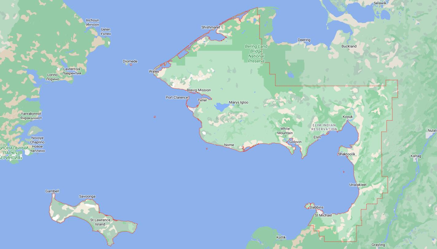
Cities and Towns in Nome Census Area, Alaska
Founded in, Nome Census Area is one of 20 boroughs in the state of Alaska. The city of is the borough seat. With FIPS code of 180, Nome Census Area has a population of 9,865 and area of 22,969 square miles (59,489 km²).
List of all cities in Nome Census Area, AK alphabetically
| City/Town | Postal Code | Area Code |
| Brevig Mission, AK | 99785 | 907 |
| Diomede, AK | 99762 | 907 |
| Elim, AK | 99739 | 907 |
| Gambell, AK | 99742 | 907 |
| Golovin, AK | 99762 | 907 |
| Koyuk, AK | 99753 | 907 |
| Little Diomede, AK | 99762 | 907 |
| Nome, AK | 99762 | 907 |
| Saint Michael, AK | 99659 | 907 |
| Savoonga, AK | 99769 | 907 |
| Shaktoolik, AK | 99771 | 907 |
| Shishmaref, AK | 99772 | 907 |
| Stebbins, AK | 99671 | 907 |
| Teller, AK | 99778 | 907 |
| Unalakleet, AK | 99684 | 907 |
| Wales, AK | 99783 | 907 |
| White Mountain, AK | 99784 | 907 |
Major Cities and Towns in Nome Census Area, Alaska
Nome
- Area: 21.6 square miles
- Population: 3,699 (as of the 2020 Census)
- Zip Codes: 99762
- Latitude and Longitude: 64.5011° N, 165.4064° W
Location and History
Nome is the largest city in the Nome Census Area, located on the southern coast of the Seward Peninsula along the Bering Sea. The town was established during the Nome Gold Rush of 1898-1899, when thousands of prospectors flocked to the area after gold was discovered on the beaches. Nome quickly became one of the largest cities in Alaska, with a population that surged to over 20,000 at the height of the gold rush. The town’s rich history is still evident today, with many remnants of the gold rush era, including old mining equipment and historic buildings. Nome also played a significant role in the 1925 Serum Run to Nome, when dog sled teams, including the famous Balto, delivered life-saving diphtheria antitoxin to the isolated community during an outbreak. Today, Nome’s economy is based on government services, tourism, and subsistence activities, with gold mining still playing a role in the local economy.
Major Schools and Landmarks
Nome is served by the Nome Public School District, with Nome-Beltz High School being the primary educational institution. The city is home to several significant landmarks, including the Carrie M. McLain Memorial Museum, which offers exhibits on Nome’s gold rush history, Native culture, and the town’s role in the 1925 Serum Run. Another key site is the Iditarod National Historic Trail, which ends in Nome and is famous for the annual Iditarod Trail Sled Dog Race. The finish line on Front Street is a focal point each March as mushers from around the world complete the grueling race. The nearby Bering Land Bridge National Preserve offers opportunities for exploring the unique geological and cultural history of the region. Nome’s blend of history, outdoor adventure, and cultural heritage makes it a vibrant and significant community in Alaska.
Unalakleet
- Area: 5.1 square miles
- Population: 746 (as of the 2020 Census)
- Zip Codes: 99684
- Latitude and Longitude: 63.8736° N, 160.7883° W
Location and History
Unalakleet is a small town located on the Norton Sound coast at the mouth of the Unalakleet River, within the Nome Census Area. The area has been inhabited by the Iñupiat and Yup’ik peoples for thousands of years, serving as a major trading hub between the coastal and interior Native groups. The town’s name means “place where the east wind blows” in the Iñupiat language. Unalakleet became a prominent supply center during the late 19th and early 20th centuries, particularly for reindeer herding and the fur trade. The town continues to be an important hub for subsistence activities, including fishing, hunting, and gathering. Today, Unalakleet is known for its rich cultural heritage, strong community ties, and as a checkpoint on the Iditarod Trail Sled Dog Race.
Major Schools and Landmarks
Unalakleet is served by the Bering Strait School District, with Unalakleet School providing education from kindergarten through 12th grade. The town is home to several important cultural landmarks, including the Unalakleet River, which is renowned for its salmon runs and is central to the community’s subsistence lifestyle. The nearby Unalakleet National Wild River offers opportunities for fishing, kayaking, and wildlife observation in a pristine wilderness setting. Another key site is the Unalakleet Native Corporation, which plays a vital role in the town’s economic and cultural life. The annual Qatnut Trade Fair celebrates the town’s history as a major trading hub, with traditional dancing, crafts, and food. Unalakleet’s blend of cultural heritage, subsistence activities, and outdoor recreation make it a unique and resilient community in the Nome Census Area.
Shishmaref
- Area: 7.3 square miles
- Population: 556 (as of the 2020 Census)
- Zip Codes: 99772
- Latitude and Longitude: 66.2561° N, 166.0714° W
Location and History
Shishmaref is a small Iñupiat village located on Sarichef Island, just off the coast of the Seward Peninsula in the Nome Census Area. The village has been inhabited for over 400 years and is known for its strong subsistence culture, with residents relying on fishing, hunting, and gathering to sustain their way of life. Shishmaref’s location on a barrier island has made it vulnerable to the effects of climate change, particularly coastal erosion and rising sea levels, which have posed significant challenges to the community. Despite these challenges, Shishmaref remains a vibrant community with deep cultural roots. The village is named after Captain Gleb Shishmarev, a Russian explorer who mapped the area in the 19th century.
Major Schools and Landmarks
Shishmaref is served by the Bering Strait School District, with Shishmaref School providing education from kindergarten through 12th grade. The village is known for its traditional lifestyle and close-knit community. A key landmark in Shishmaref is the Shishmaref Lutheran Church, which has been a central part of the community for many years. The surrounding waters and tundra provide essential resources for subsistence hunting, particularly for seals, walrus, and caribou. The annual Shishmaref Ice Classic, where residents guess the exact time the ice will break up in the spring, is a popular community event. Shishmaref’s remote location, cultural significance, and the challenges posed by climate change make it a unique and important community in the Nome Census Area.
Gambell
- Area: 10.9 square miles
- Population: 518 (as of the 2020 Census)
- Zip Codes: 99742
- Latitude and Longitude: 63.7797° N, 171.7414° W
Location and History
Gambell is a small St. Lawrence Island Yupik village located on the northwest tip of St. Lawrence Island in the Bering Sea, within the Nome Census Area. The village is one of the oldest continuously inhabited communities in Alaska, with a history that dates back over 2,000 years. Gambell was named after missionary Venia Gambell, who established a mission on the island in the late 19th century. The residents of Gambell are primarily Yupik and maintain a subsistence lifestyle, relying on marine mammals such as walrus, seals, and whales, as well as seabirds and fish. St. Lawrence Island is closer to Russia than to mainland Alaska, and the residents of Gambell have close cultural ties to Siberian Yupik communities across the Bering Strait.
Major Schools and Landmarks
Gambell is served by the Bering Strait School District, with Gambell School providing education from kindergarten through 12th grade. The village is known for its rich cultural heritage and traditional subsistence practices. A key landmark in Gambell is the Sivuqaq Dance House, where traditional Yupik dances and ceremonies are held. The nearby seabird cliffs and walrus haul-outs are important subsistence areas and attract researchers and visitors interested in the island’s unique wildlife. Gambell’s annual Nalukataq festival, celebrating the successful whale hunt, is a significant cultural event that brings the community together. The village’s remote location, cultural significance, and reliance on subsistence activities make Gambell a unique and vital community in the Nome Census Area.
Savoonga
- Area: 6.3 square miles
- Population: 671 (as of the 2020 Census)
- Zip Codes: 99769
- Latitude and Longitude: 63.6944° N, 170.4786° W
Location and History
Savoonga is a St. Lawrence Island Yupik village located on the northern coast of St. Lawrence Island in the Bering Sea, within the Nome Census Area. The village was established in the early 20th century and became a permanent settlement when the island’s reindeer population, which had been introduced in the late 1800s, grew significantly. Savoonga and its sister village Gambell are known as the “Walrus Capital of the World,” with subsistence hunting of walrus, whales, seals, and seabirds being central to the community’s way of life. The village’s economy is primarily based on subsistence activities, with residents also creating and selling traditional ivory carvings and other Native crafts. Savoonga shares close cultural ties with the Siberian Yupik people, with whom they share a common language and heritage.
Major Schools and Landmarks
Savoonga is served by the Bering Strait School District, with Hogarth Kingeekuk Sr. Memorial School providing education from kindergarten through 12th grade. The village is known for its traditional lifestyle and strong sense of community. A key landmark in Savoonga is the St. Lawrence Island Walrus Haul-Outs, where residents hunt walrus and other marine mammals that are vital to their subsistence economy. The nearby seabird cliffs are also important for hunting and gathering eggs. Savoonga’s annual events, such as the Whale Harvest Celebration, are central to the community’s cultural and social life. The village’s remote location, cultural richness, and reliance on subsistence activities make Savoonga a unique and resilient community in the Nome Census Area.
Map of Cities in Nome Census Area, AK