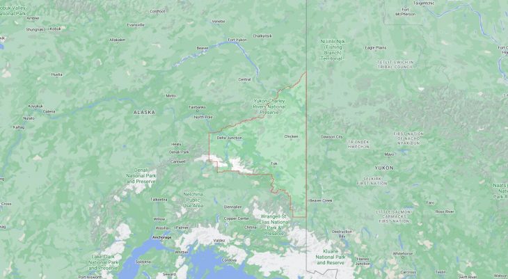
Cities and Towns in Southeast Fairbanks Census Area, Alaska
Founded in, Southeast Fairbanks Census Area is one of 20 boroughs in the state of Alaska. The city of is the borough seat. With FIPS code of 240, Southeast Fairbanks Census Area has a population of 6,970 and area of 24,831 square miles (64,312 km²).
List of all cities in Southeast Fairbanks Census Area, AK alphabetically
City/Town | Postal Code | Area Code |
Chicken, AK | 99732 | 907 |
Delta Junction, AK | 99731 | 907 |
99737 | 907 | |
Dot Lake, AK | 99737 | 907 |
Eagle, AK | 99738 | 907 |
Fort Greely, AK | 99731 | 907 |
Mentasta Lake, AK | 99780 | 907 |
Northway, AK | 99764 | 907 |
Tanacross, AK | 99776 | 907 |
Tok, AK | 99776 | 907 |
99780 | 907 |
Major Cities and Towns in Southeast Fairbanks Census Area, Alaska
Tok
- Area: 132.3 square miles
- Population: 1,243 (as of the 2020 Census)
- Zip Codes: 99780
- Latitude and Longitude: 63.3361° N, 142.9850° W
Location and History
Tok is an unincorporated community located at the junction of the Alaska Highway and the Tok Cutoff in the Southeast Fairbanks Census Area. It is often referred to as the “Gateway to Alaska” because it is the first major community that travelers encounter when entering Alaska via the Alaska Highway from Canada. Tok was originally established as a construction camp for the Alaska Highway in the 1940s. Its strategic location quickly made it an important stop for travelers, providing essential services such as gas, lodging, and supplies. Over the years, Tok has grown into a hub for tourism, transportation, and government services, particularly for those traveling to or from the interior and southeastern regions of Alaska.
Major Schools and Landmarks
Tok is served by the Alaska Gateway School District, with Tok School providing education from kindergarten through 12th grade. The community is known for its strong ties to outdoor recreation, with popular activities including snowmobiling, dog mushing, and hunting. A key landmark in Tok is the Tok Mainstreet Visitors Center, which offers information about the area and showcases local crafts and history. The surrounding wilderness provides opportunities for camping, fishing, and exploring the rugged Alaskan landscape. The annual Tok Trot, a popular event held each Fourth of July, brings the community together for a fun run and other celebrations. Tok’s combination of strategic location, outdoor adventure, and community spirit make it an essential stop for travelers and a vibrant place to live in the Southeast Fairbanks Census Area.
Delta Junction
- Area: 17.3 square miles
- Population: 1,157 (as of the 2020 Census)
- Zip Codes: 99737
- Latitude and Longitude: 64.0372° N, 145.7333° W
Location and History
Delta Junction is a city located at the junction of the Richardson Highway and the Alaska Highway in the Southeast Fairbanks Census Area. The area around Delta Junction was originally settled by Athabascan peoples and later became a stopping point for travelers and traders. The modern town was established during World War II when the Alaska Highway was constructed, and Delta Junction served as a critical link between the highway and the Richardson Highway. After the war, the region saw increased agricultural development, particularly with the establishment of the Delta Agricultural Project in the 1970s, which aimed to increase Alaska’s self-sufficiency in food production. Today, Delta Junction is known for its agricultural industry, military presence due to nearby Fort Greely, and its role as a key transportation hub in the interior of Alaska.
Major Schools and Landmarks
Delta Junction is served by the Delta/Greely School District, with Delta Junction High School being the primary educational institution. The city is home to several significant landmarks, including the Sullivan Roadhouse Historical Museum, which preserves the history of the area’s early settlers and serves as a reminder of the town’s role in Alaska’s development. Another notable landmark is the Delta Junction Visitor Center, which marks the official end of the Alaska Highway. The nearby Fort Greely is also a significant presence in the area, providing military training and missile defense operations. Delta Junction’s annual events, such as the Deltana Fair and the Golden Days Festival, celebrate the region’s agricultural heritage and community spirit. The city’s strategic location, agricultural significance, and historical importance make Delta Junction a key community in the Southeast Fairbanks Census Area.
Northway
- Area: 256.6 square miles
- Population: 290 (as of the 2020 Census)
- Zip Codes: 99764
- Latitude and Longitude: 62.9614° N, 141.9375° W
Location and History
Northway is a small, predominantly Native Alaskan community located near the Canada-U.S. border in the Southeast Fairbanks Census Area. The village is named after Chief Northway, a respected Athabascan leader. The area has been inhabited by Athabascan peoples for thousands of years, with a culture deeply connected to the land and its resources. Northway developed as a community in the 1940s with the construction of the Northway Airport, which served as a refueling stop for military aircraft during World War II. After the war, the village continued to grow, with the airport remaining a central part of the community. Today, Northway is known for its subsistence lifestyle, with residents relying on fishing, hunting, and gathering to support their way of life.
Major Schools and Landmarks
Northway is served by the Alaska Gateway School District, with Northway School providing education from kindergarten through 12th grade. The community is known for its remote location and strong cultural heritage. A key landmark in Northway is the Northway Airport, which continues to serve as an important transportation hub for the area, connecting the village to other parts of Alaska and beyond. The surrounding wilderness offers opportunities for outdoor activities such as fishing, hunting, and exploring the pristine landscape. The community’s cultural events, such as traditional potlatches and gatherings, are central to life in Northway, reflecting the deep ties to Athabascan traditions. Northway’s remote location, cultural significance, and reliance on subsistence activities make it a unique and resilient community in the Southeast Fairbanks Census Area.
Eagle
- Area: 1.5 square miles
- Population: 86 (as of the 2020 Census)
- Zip Codes: 99738
- Latitude and Longitude: 64.7883° N, 141.1994° W
Location and History
Eagle is a small city located on the south bank of the Yukon River in the Southeast Fairbanks Census Area, near the border with Canada’s Yukon Territory. The area was originally inhabited by the Han Athabascans, who used the region for hunting and fishing. Eagle was established during the Klondike Gold Rush in the late 19th century, serving as a supply center and gateway for prospectors heading to the gold fields. The town quickly grew, becoming the first incorporated city in Alaska in 1901. Eagle was also the site of Fort Egbert, a U.S. Army post that operated from 1899 to 1911, playing a key role in maintaining law and order in the region. Today, Eagle is known for its historic buildings, scenic location, and its role as a gateway to the Yukon-Charley Rivers National Preserve.
Major Schools and Landmarks
Eagle is served by the Alaska Gateway School District, with Eagle Community School providing education from kindergarten through 12th grade. The town is home to several significant landmarks, including the Eagle Historical Society and Museums, which preserves the town’s history through exhibits and restored buildings from the gold rush era. Fort Egbert, a National Historic Landmark, offers visitors a glimpse into the town’s military past with several original structures still standing. The Yukon River is central to life in Eagle, providing opportunities for fishing, boating, and access to the wilderness of the Yukon-Charley Rivers National Preserve. The town’s annual events, such as the Fourth of July celebration, reflect the strong community spirit and historical significance of Eagle. The city’s rich history, cultural heritage, and stunning natural surroundings make Eagle a unique and important community in the Southeast Fairbanks Census Area.