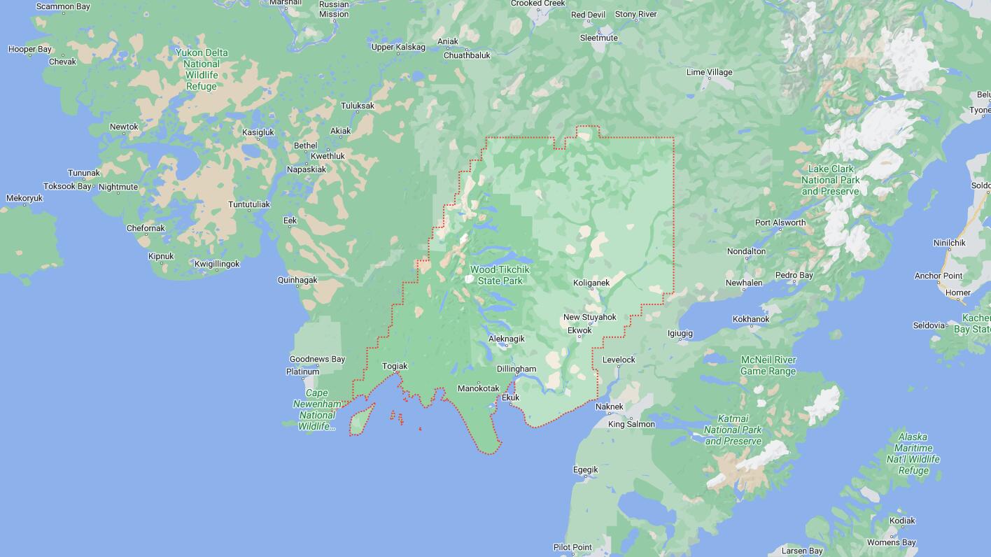
Cities and Towns in Dillingham Census Area, Alaska
Founded in, Dillingham Census Area is one of 20 boroughs in the state of Alaska. The city of is the borough seat. With FIPS code of 70, Dillingham Census Area has a population of 4,772 and area of 18,334 square miles (47,485 km²).
List of all cities in Dillingham Census Area, AK alphabetically
| City/Town | Postal Code | Area Code |
| Aleknagik, AK | 99555 | 907 |
| Clarks Point, AK | 99569 | 907 |
| Dillingham, AK | 99576 | 907 |
| Ekwok, AK | 99580 | 907 |
| Koliganek, AK | 99576 | 907 |
| Manokotak, AK | 99628 | 907 |
| New Stuyahok, AK | 99636 | 907 |
| Togiak, AK | 99678 | 907 |
| Twin Hills, AK | 99576 | 907 |
Major Cities and Towns in Dillingham Census Area, Alaska
Dillingham
Area, Population, and Coordinates
- Area: 33.6 square miles
- Population: 2,249 (as of the last census)
- ZIP Codes: 99576
- Latitude and Longitude:
- Latitude: 59.0397° N
- Longitude: 158.4575° W
Location and History
Dillingham is the largest city in the Dillingham Census Area, located in southwestern Alaska on Nushagak Bay, an inlet of Bristol Bay. The area has been inhabited by the Yup’ik people for thousands of years, who relied on the region’s abundant fish and wildlife. Dillingham was named after U.S. Senator Paul Dillingham and developed as a commercial hub in the early 20th century, primarily due to its strategic location near rich fishing grounds. The town became a center for salmon fishing, canning, and later, commercial fishing operations. Dillingham serves as a regional center for the surrounding communities, providing essential services such as healthcare, education, and transportation. The city’s economy is heavily dependent on the fishing industry, with Bristol Bay being one of the most productive salmon fisheries in the world.
Major Schools and Landmarks
Dillingham is served by the Dillingham City School District, with Dillingham Elementary School and Dillingham Middle/High School providing education from kindergarten through 12th grade. The city’s most notable landmarks include the Kanakanak Beach, a popular local spot for subsistence fishing and outdoor activities, and the Dillingham Boat Harbor, which plays a crucial role in the local fishing industry. The surrounding Bristol Bay area offers exceptional opportunities for fishing, hunting, and wildlife viewing, attracting visitors and sportsmen from around the world. The annual Beaver Round-Up festival is a significant community event, celebrating Dillingham’s cultural heritage with traditional games, dances, and other activities.
Aleknagik
Area, Population, and Coordinates
- Area: 15.4 square miles
- Population: 219 (as of the last census)
- ZIP Codes: 99555
- Latitude and Longitude:
- Latitude: 59.2733° N
- Longitude: 158.6178° W
Location and History
Aleknagik is a small village located in the Dillingham Census Area, approximately 16 miles northwest of Dillingham at the head of the Wood River. The village name, derived from the Yup’ik word “Aleknag,” meaning “wrong way home,” reflects the area’s indigenous heritage. Aleknagik was traditionally a seasonal fish camp for the Yup’ik people before it became a permanent settlement in the mid-20th century. The village is known for its picturesque setting along Lake Aleknagik, a popular destination for fishing, boating, and outdoor recreation. Aleknagik is accessible by road from Dillingham, making it one of the few communities in the region with road connectivity, which contributes to its role as a local hub for transportation and services.
Major Schools and Landmarks
Aleknagik is served by the Southwest Region School District, with Aleknagik School providing education from kindergarten through 12th grade. The village is closely associated with the Wood-Tikchik State Park, the largest state park in the United States, which offers vast wilderness areas for hiking, fishing, and wildlife viewing. Lake Aleknagik itself is a key landmark, providing a vital source of fish and a focal point for community activities. The village is also known for its subsistence lifestyle, with residents relying on the natural resources of the lake and surrounding areas for much of their food and materials.
Manokotak
Area, Population, and Coordinates
- Area: 37.6 square miles
- Population: 442 (as of the last census)
- ZIP Codes: 99628
- Latitude and Longitude:
- Latitude: 58.9811° N
- Longitude: 159.0583° W
Location and History
Manokotak is a small village in the Dillingham Census Area, located on the Igushik River, about 25 miles southwest of Dillingham. The village was established in the mid-20th century when residents from surrounding villages moved to the area for better access to resources and economic opportunities. Manokotak has a predominantly Yup’ik population, with a strong emphasis on subsistence activities such as fishing, hunting, and gathering. The village’s remote location, accessible only by air or boat, underscores its reliance on traditional ways of life and close-knit community values. The Igushik River, rich in salmon and other fish, plays a central role in the village’s economy and culture.
Major Schools and Landmarks
Manokotak is served by the Southwest Region School District, with Manokotak School providing education from kindergarten through 12th grade. The village’s most significant landmarks are its natural surroundings, particularly the Igushik River, which supports the local subsistence lifestyle and provides opportunities for fishing and hunting. The surrounding tundra and wetlands are rich in wildlife, offering residents and visitors a chance to experience the unique natural environment of southwestern Alaska. The village is also known for its traditional Yup’ik practices, including the making of handcrafts, dance, and storytelling, which are integral to the community’s cultural identity.
Togiak
Area, Population, and Coordinates
- Area: 57.0 square miles
- Population: 876 (as of the last census)
- ZIP Codes: 99678
- Latitude and Longitude:
- Latitude: 59.0622° N
- Longitude: 160.3761° W
Location and History
Togiak is a coastal village located in the Dillingham Census Area, Alaska, on the shores of Togiak Bay. The area has been inhabited by the Yup’ik people for thousands of years, and the village remains deeply rooted in indigenous culture and traditions. Togiak developed as a permanent settlement in the late 19th century, with the introduction of the commercial fishing industry playing a significant role in its growth. The village is known for its rich natural resources, including abundant fish and marine mammals, which are central to the local economy and subsistence practices. Togiak is also the gateway to the Togiak National Wildlife Refuge, one of the largest wildlife refuges in the United States, offering stunning landscapes and diverse wildlife.
Major Schools and Landmarks
Togiak is served by the Southwest Region School District, with Togiak School providing education from kindergarten through 12th grade. The village’s most notable landmarks include Togiak Bay, a vital resource for both commercial and subsistence fishing, and the nearby Togiak National Wildlife Refuge, which offers opportunities for wildlife viewing, fishing, and hunting. The refuge is home to a wide variety of species, including brown bears, caribou, and numerous bird species, making it a significant attraction for nature enthusiasts. The village’s cultural heritage is also reflected in the traditional practices of the Yup’ik people, including the making of skin boats, basket weaving, and ceremonial dances, which are celebrated during community events and gatherings.
Map of Cities in Dillingham Census Area, AK