Where is Iraq Located?
Where is Iraq located on the map? Iraq is an independent nation located in Western Asia. Check out the following images to see location of Iraq on maps.
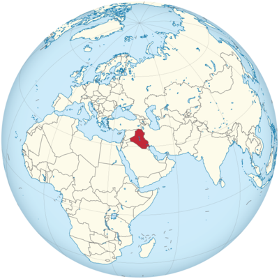
Iraq Location in World Map
On this map you can see the location of Iraq and its neighboring countries.
Location Information of Iraq
Iraq, located in the Middle East, is bordered by Turkey to the north, Iran to the east, Kuwait to the southeast, Saudi Arabia to the south, Jordan to the southwest, and Syria to the west. Iraq has a rich history and significant strategic importance due to its geographical location at the crossroads of the Arab world and Persian Gulf. Historically, Iraq was home to some of the earliest civilizations, including Sumerians, Babylonians, and Assyrians, making it one of the most important cultural centers of the ancient world.
Latitude and Longitude
Iraq is situated between 29° N and 37° N latitude, and between 38° E and 48° E longitude. Its capital, Baghdad, is located approximately at 33.3152° N latitude and 44.3661° E longitude. Iraq’s position places it in the heart of the Middle East, with a diverse range of terrain, from desert regions in the south to the mountainous regions in the north.
Capital City and Major Cities
Baghdad (Capital City)
Baghdad, the capital of Iraq, is located in the central part of the country, along the Tigris River. With a population of around 8 million, Baghdad is the largest city in Iraq and has been a major center for culture, politics, and religion for over a millennium. The city has a rich history and was a key center of learning and culture during the Abbasid Caliphate (750–1258 AD). Modern Baghdad is known for its mix of old and new architecture, vibrant markets, and historical sites, though it has been severely impacted by decades of conflict.
Notable landmarks in Baghdad include:
- The National Museum of Iraq, which houses one of the most significant collections of ancient Mesopotamian artifacts.
- Al-Mustansiriya University, founded in 1227, is one of the oldest universities in the world.
- The Grand Mosque of Baghdad and Abu Hanifa Mosque, among many other religious sites.
Basra
Located in the southern part of Iraq, near the Persian Gulf, Basra is Iraq’s second-largest city, with a population of approximately 2 million. Basra serves as the country’s main port and is a crucial hub for Iraq’s oil exports. The city is known for its oil refineries, maritime trade, and cultural heritage, including sites like the Basra Museum and Qurna, where the Tigris and Euphrates rivers meet.
Basra has faced significant challenges due to conflict, but it remains an important economic and cultural center. It is also known for its Arabian Gulf cuisine and rich history of Persian and Ottoman influences.
Mosul
Mosul, located in the northern part of Iraq, is the third-largest city in the country, with a population of around 2 million. Situated on the banks of the Tigris River, Mosul has a long history, dating back to ancient times. The city was once a major center of trade, education, and culture in the region.
Mosul is home to several notable sites, including the Great Mosque of al-Nuri and the Nineveh Ruins, remnants of the ancient Assyrian empire. The city suffered significant damage during the Iraq War, particularly from the battle against ISIS forces, but efforts to rebuild are ongoing.
Erbil
Erbil, the capital of the Kurdistan Region of Iraq, is located in the northern part of the country, approximately 350 km north of Baghdad. With a population of about 1.5 million, Erbil is one of the oldest continuously inhabited cities in the world, with a history that dates back over 6,000 years. Erbil is known for its ancient citadel, a UNESCO World Heritage Site, and its role as a hub of Kurdish culture and politics.
Erbil is a thriving city with a growing economy, particularly in sectors like construction, tourism, and retail. The Kurdistan Region enjoys a degree of autonomy from the central government in Baghdad, and Erbil is often considered a safer, more stable area of Iraq.
Najaf and Karbala
Located in the southern part of Iraq, Najaf and Karbala are two of the most important cities in the country for Shiite Muslims. Najaf is home to the Imam Ali Shrine, one of the holiest sites for Shiite Muslims. Karbala is known for the Imam Hussein Shrine, where the martyrdom of Imam Hussein, the grandson of the Prophet Muhammad, is commemorated annually during Ashura. These cities draw millions of pilgrims each year.
Time Zone
Iraq follows Arabian Standard Time (AST), which is UTC +3 throughout the year. Unlike many other countries in the region, Iraq does not observe Daylight Saving Time. This time zone places Iraq in the same time zone as other Middle Eastern countries such as Saudi Arabia, Kuwait, and Bahrain.
Climate
Iraq has a desert climate with hot summers and mild winters. The climate is characterized by extreme temperatures and low rainfall, particularly in the central and southern regions. The climate varies depending on the topography, with more moderate conditions in the north and harsher conditions in the south.
Summer
Summer in Iraq is extremely hot, with temperatures in the central and southern regions often exceeding 40°C (104°F) during the day, sometimes reaching as high as 50°C (122°F) in desert areas. The northern regions, particularly the Kurdish region, enjoy somewhat cooler temperatures due to higher elevations, but summer temperatures still average around 35°C (95°F).
Winter
Winter in Iraq is generally mild, with temperatures in the central and southern regions ranging from 5°C (41°F) to 15°C (59°F). Snowfall is rare, though it can occur in the northern mountainous areas, particularly in the Kurdistan Region. The Kurdistan Region enjoys a more temperate climate due to its mountainous terrain, with cooler winters and occasional snowfall.
Rainfall
Rainfall in Iraq is generally sparse, with most areas receiving less than 200 mm (8 inches) of rain per year. The northern regions, particularly around Erbil, receive more rainfall, while the southern and central parts of the country are dry and arid. Most of the country’s precipitation occurs during the winter months.
Economic Status
Iraq’s economy is heavily dependent on its oil reserves, which are some of the largest in the world. Oil exports make up over 90% of Iraq’s revenue, with the country being a key member of the Organization of the Petroleum Exporting Countries (OPEC). Despite its vast oil wealth, Iraq faces several economic challenges, including infrastructure damage, corruption, and security instability due to ongoing conflict.
Key Sectors
- Oil and Gas: Iraq’s economy is largely driven by its oil and gas industry. The country has the fifth-largest proven oil reserves in the world, and the oil sector contributes significantly to both the national income and employment. However, the country’s reliance on oil makes its economy vulnerable to fluctuations in global oil prices.
- Agriculture: Agriculture plays a smaller role in Iraq’s economy compared to oil, but it is still important, particularly in the Tigris-Euphrates river valley. Iraq produces crops such as wheat, barley, dates, and vegetables. However, water scarcity and poor irrigation infrastructure have affected agricultural productivity.
- Manufacturing: Iraq has a relatively small manufacturing sector, producing goods such as cement, chemicals, and construction materials. The country also has the potential for developing its textile and food processing industries.
Economic Challenges
Iraq faces significant challenges in rebuilding its economy after decades of conflict, including the 2003 U.S.-led invasion, the subsequent rise of ISIS, and regional instability. The country struggles with high unemployment, inflation, and poverty, particularly in the southern and rural areas. The Iraq Reconstruction Fund and foreign investment have been essential to rebuilding infrastructure, but security concerns and political instability have hindered progress.
Tourist Attractions
Iraq is home to many historical and cultural landmarks, but tourism has been greatly affected by decades of conflict and instability. However, Iraq’s rich archaeological heritage, particularly from ancient Mesopotamia, still attracts visitors.
Ancient Mesopotamia
Iraq is often referred to as the cradle of civilization, as it was home to the Sumerians, Babylonians, and Assyrians, who developed some of the world’s earliest cities, writing systems, and legal codes. Notable archaeological sites include:
- Babylon, the ancient city of Nebuchadnezzar II, famous for the Hanging Gardens and Ishtar Gate.
- Nineveh, the capital of the Assyrian Empire, which contains significant archaeological sites such as the Palace of Sennacherib and the Nimrud Ruins.
Religious Sites
Iraq is home to many significant religious landmarks, particularly for Shiite Muslims. These include the shrines of Imam Ali in Najaf and Imam Hussein in Karbala, two of the holiest sites in Shiite Islam. Pilgrims travel to Iraq to honor the memory of these revered figures, especially during the annual observance of Ashura.
Erbil Citadel
The Erbil Citadel is an ancient hilltop fortification that has been continuously inhabited for over 6,000 years. It is a UNESCO World Heritage Site and offers a glimpse into Iraq’s rich history. The citadel, with its traditional Kurdish architecture, provides panoramic views of the surrounding city and landscape.
Visa Requirements for U.S. Citizens
U.S. citizens traveling to Iraq for tourism or business purposes are required to obtain a visa prior to entering the country. The process involves submitting an application to an Iraqi consulate or the Iraqi Embassy in Washington, D.C. U.S. citizens must also provide supporting documentation, such as a valid passport, invitation letter, and visa fee.
U.S. citizens traveling to Iraq must also be aware of the country’s security situation and may need to obtain special permits to enter certain regions, especially those affected by conflict.
Distance to New York City and Los Angeles
- From New York City to Baghdad: The distance between John F. Kennedy International Airport (JFK) and Baghdad International Airport (BGW) is approximately 5,600 miles (9,000 kilometers). A direct flight typically takes around 11-12 hours.
- From Los Angeles to Baghdad: The distance between Los Angeles International Airport (LAX) and Baghdad International Airport (BGW) is approximately 7,100 miles (11,400 kilometers). Flights from Los Angeles to Baghdad usually take about 13-14 hours.
Iraq Facts
| Size | 438.317 km² |
| Residents | 39.3 million |
| Languages | Arabic and Kurdish |
| Capital | Baghdad |
| Longest river | Tigris (1,400 km in Iraq) |
| Highest mountain | Cheekha Dar (3,611 m) |
| Currency | Iraqi dinar |


