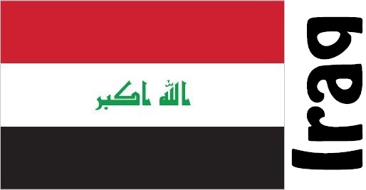
Iraq Facts
Iraq, Middle Eastern state; 438,300 km², 38.4 million residents (2019).Iraq borders in the south to Saudi Arabia and Kuwait, in the west to Jordan and Syria, in the north to Turkey and in the east to Iran. At Shatt al-Arab in the south-east there is a narrow connection with the Persian Gulf. The capital is Baghdad, which in 2015 had 8.8 million residents.
Country facts
- al-Jumhūrīya al-raIraqiyya / Republic of Iraq
- Country abbreviation: IQ
- Area: 438 300 km²
- Population (2019): 38.4 million residents
- Capital: Baghdad
- Main languages: Arabic
- State: Republic
- Head of State: Barham Salih (President)
- Head of Government: Muhammad Tawfiq Allawi
- Per capita GDP (2018): US $ 5,878
- GNI per capita (2018): US $ 5,030
- Currency unit: 1 Iraqi dinar = 1,000 fils
- Currency code: IQD
- Country number (telephony): 964
- Internet Domain Name: iq
- Time difference compared to Sweden: +2
- National Day: July 17 (Revolution Day, 1968)
- Independence Day: October 3, 1932
Nature
- Land use: forest (0.4%), agricultural land (13%), other (87%)
- Highest mountain: Rawanduz (3,658 m above sea level)
- Longest rivers: Euphrates (2,800 km), Tigris (1,900 km)
Population
- Population density (2019): 88 residents per km²
- Natural population growth (2019): 2.4%; birthrate 29 ‰, death count 5 ‰
- Age structure (2019): 0-14 years (39%), 15-64 (58%), 65- (3%)
- Average life expectancy (2019): men 68 years, women 72 years
- Infant mortality (2019): 23 per 1,000 live births
- Population forecast 2050: 71 million residents
- HDI (2017): 0.685 (place 120 of 189)
- Urbanization rate (2019): 71%
- Most populous cities (2015): Baghdad (8.8 million residents), Mosul (664,200)
Business
- Industry’s contribution to GDP (2017): agriculture (3%), industry (51%), service (46%)
- Exports (2017): US $ 61,400 million
- Main export product: oil
- Main exporting countries: India, China, USA
- Imports (2017): US $ 39,470 million
- Main import products: food, medicine, industrial goods
- Main importing countries: Turkey, China, South Korea
- Railway network (2012): 2,300 km
Geography
Location and Borders
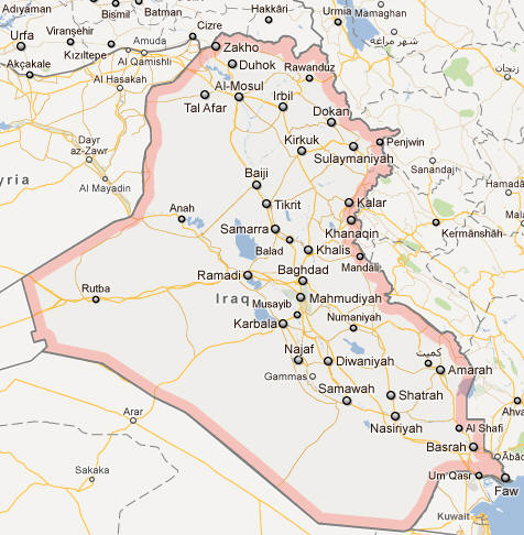
Iraq is located in Western Asia, bordered by six countries: Turkey to the north, Iran to the east, Kuwait to the southeast, Saudi Arabia to the south, Jordan to the southwest, and Syria to the west. To the northeast, Iraq shares a small border with Armenia, through the Turkish-Iraqi frontier. Its total land area spans around 438,317 square kilometers, making it one of the largest countries in the Middle East.
The country’s position in the heart of the Middle East has historically given it great geopolitical significance. Iraq’s strategic location has made it a bridge between the Arab world and the Persian world, as well as a crossroads for trade routes connecting Europe, Asia, and Africa. Additionally, Iraq has access to the Persian Gulf, providing it with a key outlet for oil exports and trade.
Major Landforms
Iraq’s geography is diverse, featuring deserts, rivers, and mountain ranges. The majority of the country is composed of flat plains, particularly in the central and southern regions, which are part of the Mesopotamian Basin. The Tigris and Euphrates Rivers, which flow through the country from the north to the south, have historically been the lifeblood of Iraq, providing water for agriculture, transportation, and settlement. These rivers join in the southern part of the country before emptying into the Shatt al-Arab, which flows into the Persian Gulf.
To the north, Iraq’s terrain becomes more rugged, with the Zagros Mountains forming the border with Iran. These mountains are among the most important geographical features in Iraq, reaching heights of over 3,000 meters and marking the eastern edge of the country. The mountain ranges create a natural barrier, affecting both the climate and settlement patterns.
The western part of Iraq consists mainly of desert and semi-desert regions, including the Syrian Desert, which stretches into Iraq from Syria and Jordan. These arid landscapes are sparsely populated and consist of sand dunes, rocky plateaus, and small oases. While these desert areas are not as conducive to agriculture, they have played an important role in the country’s military history and movements.
Rivers and Lakes
The Tigris and Euphrates Rivers are the most significant bodies of water in Iraq. These two rivers flow from Turkey, through Iraq, and into Syria, providing irrigation for much of Iraq’s agriculture and serving as major transportation routes. The Euphrates, being the larger of the two, is critical for water supply and agriculture in the central and southern regions of Iraq, where much of the population resides. The Tigris, on the other hand, flows through the northern part of the country, passing through the capital, Baghdad.
The southern part of Iraq is home to the Shatt al-Arab, a large waterway formed by the confluence of the Tigris and Euphrates. This river has been central to trade and commerce, linking Iraq to the Persian Gulf. The marshlands around the southern rivers, known as the Mesopotamian Marshes, are also significant in terms of biodiversity and have been recognized as a UNESCO World Heritage site.
While Iraq has no significant natural lakes, it does have several artificial reservoirs created by dams on the Tigris and Euphrates rivers. These dams, such as the Saddam Dam near the northern city of Mosul, are crucial for flood control, irrigation, and generating hydroelectric power.
Climate
Desert and Continental Climate Zones
Iraq experiences a hot desert climate, characterized by scorching summers, mild winters, and very little rainfall. The climate varies slightly across the country, but in general, Iraq is known for its arid conditions, especially in the central and southern regions.
The summer months, from May to September, are extremely hot, with daytime temperatures often exceeding 40°C (104°F) in many areas, particularly in the southern plains. The desert regions can experience temperatures as high as 50°C (122°F), especially in cities like Basra and Nasiriyah. Nights can be relatively cooler, but the heat remains intense.
In contrast, winters in Iraq are generally mild, with temperatures averaging between 8°C and 15°C (46°F to 59°F). However, in the northern mountainous regions, winter temperatures can drop significantly, with occasional snowfall in areas like Erbil and Sulaymaniyah. The mountainous areas receive more precipitation than the rest of the country, with some regions getting rain and snow during the winter months.
Rainfall is scarce throughout Iraq, particularly in the central and southern regions. The north receives more precipitation, especially in the mountainous areas, but the country as a whole experiences an average annual rainfall of around 200 mm. Rainfall is most frequent during the winter months, from November to March, while summer is typically dry, contributing to the country’s vulnerability to droughts.
Seasonal Variation
The primary seasons in Iraq are summer, winter, and a short transition period during spring and autumn. Spring and autumn are relatively mild but brief, with temperatures rising rapidly toward the summer heat and then dropping after the summer season ends.
Spring in Iraq is typically marked by pleasant weather with moderate temperatures, making it a favorable time for agriculture. However, the summer heat can quickly dry up crops and disrupt the agricultural season, especially in the central and southern parts of the country. Fall also brings moderate temperatures, with the autumn harvests being an important part of Iraq’s agricultural cycle.
The extreme summer temperatures are a major challenge in Iraq, affecting daily life, agricultural productivity, and the overall economy. Water scarcity, which is exacerbated by the hot, dry climate, is another significant issue, particularly in the southern regions that rely heavily on irrigation from the Tigris and Euphrates rivers.
People
Demographics
Iraq has a population of around 40 million people, making it one of the larger countries in the Middle East. The population is diverse in terms of ethnicity, religion, and culture, with Arabs making up the majority of the population. Other significant ethnic groups include Kurds, Turkmen, Assyrians, and Armenians. The Kurdish population primarily resides in the northern regions of Iraq, especially in the Kurdistan region, while Arabs dominate the central and southern parts of the country.
Iraq’s demographics are further shaped by its religious diversity. The majority of Iraqis are Muslim, with the population being predominantly Shiite in the south and Sunni in the central and western regions. The Kurdish population is also predominantly Sunni Muslim, though there are small Christian, Yazidi, and other religious minorities.
Iraq’s population is relatively young, with a large percentage under the age of 30. This youthful demographic presents both opportunities and challenges for the country, as it seeks to provide education, employment, and services to its growing population. However, Iraq’s population has been affected by years of conflict, displacement, and migration, which has led to a significant number of refugees both within and outside the country.
Language and Religion
The official languages of Iraq are Arabic and Kurdish, reflecting the country’s ethnic and regional divisions. Arabic is the dominant language spoken by the majority of Iraqis, while Kurdish is spoken by the Kurdish population in the northern regions, particularly in the Kurdistan Regional Government (KRG) areas. Both Arabic and Kurdish are used in government, education, and media.
In terms of religion, Iraq is predominantly Muslim, with the majority of the population adhering to Shiite Islam, particularly in the southern and central regions. Sunni Muslims make up a significant portion of the population, particularly in central and western Iraq. Kurdish Iraqis are predominantly Sunni, although they have their own unique cultural and religious practices. Iraq also has small Christian, Yazidi, and other religious communities, with Christians primarily living in northern Iraq, particularly in the Nineveh Plains.
The religious landscape of Iraq has been shaped by centuries of Islamic and Christian history, with Iraq being the birthplace of some of the earliest civilizations, including the Sumerians, Babylonians, and Assyrians. Over time, the religious and cultural influence of these groups has left a lasting mark on Iraqi society.
Economy
Economic Overview
Iraq’s economy is heavily dependent on oil, which accounts for about 90% of the country’s export revenues and a significant portion of its GDP. The country holds some of the largest proven oil reserves in the world, particularly in the southern region around Basra. Oil extraction and exports are vital to Iraq’s economic performance, with much of the revenue generated by oil sales used to fund the government and infrastructure projects.
Iraq’s economy also relies on agriculture, though this sector is much smaller in comparison to oil. Agriculture is concentrated in the fertile lands of the Tigris and Euphrates River valleys, where crops like wheat, barley, rice, and vegetables are grown. However, the agricultural sector faces challenges from water scarcity, irrigation dependency, and the impact of climate change, which have led to reduced productivity in recent years.
The services sector in Iraq, including banking, education, and healthcare, has been significantly impacted by years of war and conflict. However, the country is working toward rebuilding its infrastructure and improving its social services. Foreign investment, particularly in the oil and gas sectors, has been a key driver of economic recovery, though Iraq continues to face challenges related to corruption, political instability, and security concerns.
Challenges and Opportunities
While Iraq’s oil wealth provides significant opportunities for economic growth, the country faces a number of challenges, including political instability, corruption, and security issues. The ongoing conflict with the Islamic State (ISIS) and the aftermath of years of war have left parts of the country devastated, with large areas requiring reconstruction.
Iraq also faces significant challenges related to infrastructure, education, and healthcare. Despite having vast oil reserves, the country has struggled to develop its non-oil sectors and diversify its economy. This reliance on oil has made Iraq vulnerable to fluctuations in global oil prices, which can impact government revenues and economic stability.
However, Iraq has substantial opportunities for growth, particularly in its oil and gas sectors, as well as in agriculture, construction, and services. Efforts to reduce dependency on oil, diversify the economy, and improve governance and infrastructure are ongoing, with international assistance and foreign investment being key factors in the country’s economic future.
Government
Political Structure
Iraq is a federal parliamentary republic, with a political system that combines elements of democracy and federalism. The country’s political structure was established under the 2005 Constitution, following the fall of Saddam Hussein’s regime and the subsequent U.S.-led invasion in 2003. Iraq’s government is based on a separation of powers, with an executive branch, a legislative branch, and a judiciary.
The President of Iraq is the head of state and serves a ceremonial role, while executive power is vested in the Prime Minister, who is the head of government. The Prime Minister is appointed by the President and must receive approval from the Iraqi parliament. The legislature, known as the Council of Representatives, is a unicameral body consisting of 329 members elected by the people through a proportional representation system.
Iraq’s federal system includes a regional government for the Kurdistan region in the north, which has its own parliament and President. This arrangement is part of the broader political agreement between the central government in Baghdad and the autonomous Kurdish regional government.
Political History
Iraq’s political history has been marked by periods of conflict, dictatorship, and foreign intervention. Following its independence from Britain in 1932, Iraq became a monarchy until a coup in 1958 led to the establishment of a republic. Over the next several decades, Iraq experienced instability, with numerous coups and changes in leadership.
Saddam Hussein came to power in 1979, establishing a brutal regime that lasted until his overthrow in 2003. Hussein’s regime was characterized by authoritarian rule, the suppression of minority groups, and a series of violent conflicts, including the Iran-Iraq War (1980-1988) and the Gulf War (1990-1991). His regime came to an end after the U.S.-led invasion in 2003, which led to the collapse of his government and the subsequent rise of sectarian violence and instability.
The post-Saddam era saw the establishment of a new democratic government, though Iraq has continued to experience political and sectarian divisions, as well as violence from insurgent groups like ISIS. While Iraq has made progress in rebuilding its political institutions, it continues to face significant challenges related to governance, corruption, and security.
Culture
Art and Music
Iraqi culture is deeply influenced by its ancient history, with contributions to art, literature, and music dating back thousands of years. Iraq is home to some of the world’s earliest known civilizations, including the Sumerians, Babylonians, and Assyrians. The art and architecture of these ancient cultures, including their ziggurats and clay tablets, continue to inspire modern-day Iraqis.
In terms of music, Iraq has a rich tradition, particularly in classical Arabic music. The oud (a stringed instrument) and the darbuka (a type of drum) are common instruments used in Iraqi music, which spans a range of traditional and modern styles. The maqam, a traditional form of Iraqi classical music, is highly regarded and often performed in concert halls and cultural festivals.
Festivals and Cuisine
Iraq is home to various cultural and religious festivals, many of which are tied to Islam. The most important religious festivals are Eid al-Fitr and Eid al-Adha, which are celebrated by Muslims across the country. In addition to these, the Shia Muslim community observes Ashura, which marks the martyrdom of Imam Hussein, with processions and ceremonies throughout Iraq.
Iraqi cuisine is characterized by its use of spices, rice, lamb, and vegetables. Dishes like kebabs, dolma (stuffed grape leaves), and masgouf (grilled fish) are staples of Iraqi food. The national dish, biryani, reflects a blend of Persian, Arab, and Indian influences. Iraq’s culinary heritage is also heavily influenced by its regional and religious diversity, with various communities contributing to the country’s rich food traditions.
Literature and Cinema
Iraq has a long literary tradition, with notable contributions to Arabic literature, particularly in poetry. Writers like Nizar Qabbani and Mahmoud Darwish are celebrated throughout the Arab world, and their works have shaped modern Arabic poetry and prose. Iraqi literature is marked by themes of exile, identity, and the effects of war.
In cinema, Iraq has a growing film industry, despite the challenges posed by years of conflict and instability. Iraqi filmmakers have used film to explore themes of trauma, survival, and hope. While Iraq’s film industry is still developing, films like Turtles Can Fly (2004), which deals with the impact of the Iraq War on children, have gained international recognition.
Iraq Map