Comoros Facts
Comoros, African state of the Indian Ocean; 2,200 km², 832,000 residents (2019).The Comoros, located in the Mozambique Canal northwest of Madagascar, consist of several islands, of which Ngazidja (Grande Comore), Mwali (Mohéli) and Nzwani (Anjouan) are the largest. Claims are also made on the island of Mayotte (Mahoré), which, however, still constitutes a French “collectivité territoriale”. The capital is Moroni (54,000 residents, 2011) on Ngazidja.
Country facts
- Jumhuriyyat al-Qumur al-Ittihadiyya al-Islamiyya / Union of the Comoros
- Country abbreviation: KM
- Area: 2 200 km²
- Population (2019): 832,000 residents
- Capital: Moroni
- Main languages: Arabic, French, Shikomor (Comoro, Comorian)
- State: Republic
- Head of State and Head of Government: Azali Assoumani (President)
- Per capita GDP (2018): US $ 1,446
- GNI per capita (2018): US $ 1,320
- Currency: 1 franc = 100 centimes
- Currency code: KMF
- Country number (telephony): 269
- Internet domain name: km
- Time difference compared to Sweden: +2
- National Day: July 6 (Independence Day, 1975)
Nature
- Highest mountain: Kartala (2,361 m above sea level)
Population
- Population density (2019): 378 residents per km²
- Natural population growth (2019): 2.5%; birth number 32 ‰, death number 7 ‰
- Age structure (2019): 0-14 years (39%), 15-64 (58%), 65- (3%)
- Life expectancy (2019): men 62 years, women 66 years
- Infant mortality (2019): 54 per 1,000 live births
- Population forecast 2050: 2 million residents
- HDI (2017): 0.503 (place 165 of 189)
- Urbanization rate (2019): 29%
- Most populous city (2011): Moroni (54,000 residents)
Business
- Industry’s contribution to GDP (2017): agriculture (48%), industry (12%), service (40%)
- Exports (2017): US $ 19 million
- Main export product: vanilla
- Main exporting countries: France, India, Germany
- Imports (2017): US $ 208 million
- Main import products: rice, oil products, meat
- Main importing countries: United Arab Emirates, France, China
- Railway network: nothing in operation
Geography
Location and Borders
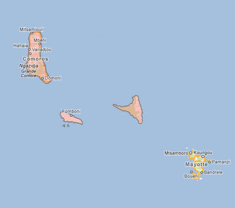
The Comoros is an island nation located in the Indian Ocean, off the southeastern coast of Africa, between Madagascar and Mozambique. The country consists of three major islands: Grande Comore, Mohéli, and Anjouan, along with several smaller islets. The capital city, Moroni, is situated on the island of Grande Comore. The islands are part of the Comoros archipelago, which lies approximately 300 kilometers (190 miles) from Madagascar and 1,500 kilometers (930 miles) from the mainland of Africa. The Comoros is surrounded by the Mozambique Channel to the west, the Indian Ocean to the south and east, and the island of Madagascar to the southwest.
Comoros’ strategic location has historically made it an important stop for trade routes linking Africa, Asia, and the Middle East. Despite its small size, the Comoros’ geographical position has shaped its culture, economy, and political history over the centuries.
Topography and Natural Features
The topography of the Comoros islands is characterized by volcanic activity, steep mountains, deep valleys, and lush vegetation. The islands are of volcanic origin, and their landscapes are dominated by rugged terrain and towering peaks. The highest point in the country is Mount Karthala, located on Grande Comore, which rises to about 2,361 meters (7,746 feet) above sea level. Mount Karthala is an active volcano and is one of the largest volcanoes in the world by area. Its eruptions have shaped the islands’ landscape over the centuries.
Grande Comore, the largest of the islands, is home to volcanic craters, lava plains, and coastal plains. Mohéli, the smallest island, is known for its rich biodiversity, with tropical forests, beaches, and coral reefs. Anjouan, the second-largest island, features a more diverse landscape, with lush forests, waterfalls, and a mountainous terrain that is highly fertile.
The waters surrounding the Comoros are rich in marine life, and the country has an extensive coral reef system that provides critical habitats for a variety of species. The islands’ biodiversity is notable, particularly in the areas of flora and fauna, with a mix of tropical, subtropical, and marine ecosystems supporting a range of endemic species.
Climate and Seasonal Variation
The climate of the Comoros is tropical, with high temperatures and humidity throughout the year. The islands experience two main seasons: the wet season and the dry season. The wet season lasts from November to April, bringing heavy rains and thunderstorms, particularly to the windward sides of the islands. This period is characterized by high humidity and warm temperatures, ranging from 25°C (77°F) to 30°C (86°F). The wet season is essential for the islands’ agriculture, particularly for crops such as vanilla, cloves, and coconuts.
The dry season, from May to October, is marked by less rainfall and cooler temperatures, with daytime temperatures ranging between 23°C (73°F) and 28°C (82°F). This season is the best time for tourism, as the weather is more pleasant and there is less chance of heavy rainfall, allowing for exploration of the islands’ natural beauty.
Despite the warm tropical climate, the islands are susceptible to cyclones, particularly during the wet season, which can cause significant damage to infrastructure, homes, and agriculture. Coastal erosion and rising sea levels also pose long-term threats to the islands, as much of the country’s population lives along the shoreline.
People
Population and Demographics
The Comoros has a population of approximately 850,000 people, making it one of the smallest countries in the world by population. The majority of the population lives on the islands of Grande Comore, Mohéli, and Anjouan, with the largest urban centers being the capital, Moroni, on Grande Comore, and Mutsamudu on Anjouan. The population is relatively young, with a significant proportion under the age of 25.
The demographic composition of the Comoros is primarily of Arab, African, and Malagasy descent, reflecting the diverse history of the islands, which have seen influences from various cultures, including African, Arab, Persian, Indian, and European settlers. The Arab influence is particularly strong in the islands’ culture, as many of the early settlers came from the Arabian Peninsula. The African influence comes from the mainland of Africa, while the Malagasy influence is a result of historical migration from Madagascar.
The majority of the population adheres to Islam, with Islam being a central part of cultural and social life. A small percentage of the population practices Christianity, mainly in the form of Roman Catholicism, although these groups are a minority in the country.
Languages
The official languages of the Comoros are Comorian, Arabic, and French. Comorian is a group of closely related languages spoken by the majority of the population and is the primary language used in daily life, communication, and informal settings. It is a blend of Arabic, Bantu, and Malagasy languages, and the various islands have their distinct dialects. The Comorian language is part of the larger Bantu language family, and it is spoken in different variations across the islands.
Arabic is widely used for religious purposes, particularly in the practice of Islam, and is the language of the Quran, which is studied and recited in Arabic by the majority of the population. French, the colonial language of the country, remains the language of administration and governance, as well as being used in education and business, especially in urban areas.
Religion
Islam is the dominant religion in the Comoros, with approximately 98% of the population identifying as Muslim. Islam was introduced to the islands as early as the 7th century, and it has deeply influenced the culture, traditions, and daily life of the Comoros. Most Muslims in the Comoros adhere to Sunni Islam, and religious observance is an essential part of life, with daily prayers, fasting during Ramadan, and other Islamic practices taking center stage in the community.
The country also has a small Christian minority, primarily Roman Catholics, but their numbers are small compared to the Muslim population. Christianity was introduced by French missionaries during the colonial period, and the Christian community is largely concentrated in urban areas such as Moroni.
Despite the dominance of Islam, the Comoros is a relatively tolerant country with respect to religious practices. Both Muslims and Christians coexist peacefully, although the overall influence of religion on politics and society remains strong, particularly in education and public life.
Economy
Overview
The economy of the Comoros is small and heavily dependent on agriculture, fishing, and remittances from the large diaspora community abroad. The country has limited industrial activity, and its services sector remains underdeveloped. While the Comoros has rich natural resources, including fertile land for farming, its economic development has been hindered by political instability, poor infrastructure, and its geographical isolation.
Agriculture is the primary economic activity in the Comoros, with the islands producing crops such as vanilla, cloves, ylang-ylang (a flower used in perfumes), bananas, and coconuts. The country is one of the world’s leading producers of ylang-ylang, which is used in the fragrance industry. The country’s volcanic soil and tropical climate are ideal for these cash crops, but the agricultural sector remains vulnerable to climate change and cyclones.
The Comoros also relies on fishing as a key industry, with tuna and other marine products being important exports. The fishing industry contributes to both domestic food supply and exports, particularly to Asian markets. Despite its rich marine resources, the country faces challenges in developing its fishing sector fully due to limited infrastructure and underinvestment.
Remittances from Comorians living abroad, particularly in France, play an important role in the country’s economy, with migrant workers sending money back to their families. This financial support helps the Comoros’ domestic economy and provides a lifeline for many families.
Agriculture and Natural Resources
Agriculture is the backbone of the Comoros economy, providing both food for the population and important export goods. The Comoros’ tropical climate is ideal for producing crops like vanilla, cloves, ylang-ylang, and coconuts, which are grown for export. The Comoros is the world’s second-largest exporter of vanilla, and the islands’ unique aromatic spices and flowers are highly valued in global markets.
The country also produces a variety of other crops, such as bananas, cassava, sweet potatoes, and maize, which are grown primarily for domestic consumption. Livestock farming is limited but includes goats, cattle, and poultry, which provide meat and milk to the local population.
Fishing plays a crucial role in the economy, especially in the export of tuna, which is one of the most valuable resources. The government has been working on sustainable fishing practices to ensure long-term profitability and to mitigate the effects of overfishing. Additionally, the Comoros’ coastal waters are rich in marine life, offering potential for the development of eco-tourism, a sector that remains underdeveloped.
Services and Industry
The industrial sector in the Comoros is relatively small, with limited infrastructure to support large-scale manufacturing. There is some production in the processing of agricultural products, including vanilla and cloves, but these industries remain underdeveloped and face challenges related to infrastructure and investment. The Comoros has a few small factories producing goods such as construction materials, clothing, and food products.
The services sector is small but growing, with tourism being a key area of potential growth. The Comoros has natural beauty, pristine beaches, and rich cultural heritage that make it an attractive destination for eco-tourism and cultural tourism. However, the country’s tourism industry remains underdeveloped due to limited infrastructure, political instability, and the lack of marketing to international tourists.
Transport and telecommunications infrastructure are underdeveloped, with most goods and services being imported. This affects domestic industry and limits the country’s ability to expand its manufacturing and trade sectors. The government has been making efforts to improve infrastructure, including the development of ports and airports, but progress remains slow.
Government
Political System
The Comoros is a federal Islamic republic with a history of political instability and military coups. The country has experienced frequent changes in government since gaining independence from France in 1975. The political system is based on a multi-party framework, with the president serving as both head of state and government. However, the executive powers of the president are limited by a system of rotational power-sharing among the three islands of the Comoros.
The government structure of the Comoros is unique in that it is divided into three autonomous islands, each with its own president and local government. The president of the Comoros is elected every five years by popular vote. The three islands—Grande Comore, Anjouan, and Mohéli—are governed by their respective presidents, who rotate the position of the presidency at the national level.
The Comoros has struggled with political instability and armed conflict, which have impeded the country’s development. Despite efforts to stabilize the country, military coups and disputes over power-sharing have been frequent throughout its history. The Comoros has been working to develop democratic institutions and promote peaceful transitions of power.
Legal System
The Comoros has a legal system based on a combination of Islamic law (Sharia), civil law, and customary law. The country’s legal framework incorporates aspects of Islamic jurisprudence, particularly in matters related to family law, inheritance, and personal status. The legal system is influenced by the country’s Islamic heritage, but it also includes elements of the French legal system, a legacy of its colonial past.
The judiciary is intended to be independent, but the Comoros faces challenges related to corruption and limited resources within the legal system. Access to justice is uneven, particularly in rural areas where customary law is more commonly applied. There is an ongoing effort to modernize and improve the judicial system, but progress has been slow due to political instability and resource constraints.
Foreign Relations
The Comoros maintains diplomatic relations with several countries, particularly those in the Arab world and Africa. The country is a member of the African Union, the Arab League, and the Organization of Islamic Cooperation (OIC), and it has historically sought to strengthen ties with other Muslim-majority nations. Relations with France, the former colonial power, remain important, though the relationship is often marked by a degree of tension due to the country’s desire for greater political independence.
The Comoros has also sought closer ties with its neighboring African countries, particularly those in the Indian Ocean region. It has been involved in regional peacekeeping efforts and diplomatic initiatives aimed at resolving conflicts within the region. However, the Comoros’ political instability and limited resources have often hindered its ability to play a significant role in international affairs.
Culture
Arts and Music
The culture of the Comoros is a blend of African, Arab, and Malagasy influences, reflected in the country’s music, art, and literature. Traditional arts in the Comoros include weaving, wood carving, and pottery, often with intricate designs inspired by local customs and beliefs. These crafts are produced by indigenous communities and are often used in daily life, as well as for ceremonial purposes.
Music plays a significant role in Comorian culture, with a variety of styles rooted in African and Arab traditions. Taarab, a form of Swahili music, is popular on the island of Comoros, and it combines African rhythms with Arab melodies. Other local music genres include Maki, which is based on African rhythms and dances, and Chant de Comores, which incorporates island storytelling traditions through song. Traditional dance is an essential part of social gatherings, and music festivals are an important aspect of community life.
Cuisine
Comorian cuisine reflects its rich cultural influences, with dishes combining ingredients and techniques from Africa, the Arab world, and Madagascar. Rice and cassava are staple foods, often served with fish, chicken, or goat meat. Spices such as cloves, cinnamon, and vanilla, which are grown on the islands, are key ingredients in Comorian dishes, adding fragrant flavors and depth to the food.
A typical Comorian dish might include “M’godro”, a fried dough dish made with bananas and flour, or “Mataba”, a dish of boiled cassava served with a spicy sauce. The islands’ abundant coconut trees also play a key role in local cuisine, with coconut milk being used to flavor both savory and sweet dishes. “Kaba”, a type of sweet dessert made from coconut and sugar, is a popular treat on the islands.
Festivals and Traditions
The Comoros celebrates a range of festivals and cultural events that reflect the country’s diverse cultural heritage. Eid al-Fitr and Eid al-Adha are the most important Islamic holidays, marked by prayers, feasts, and family gatherings. The Comoros Independence Day, celebrated on July 6th, is a national holiday that commemorates the country’s independence from France in 1975. This day is marked by parades, ceremonies, and cultural events.
In addition to religious festivals, the Comoros hosts cultural events and gatherings that showcase traditional music, dance, and crafts. The Festival of Ylang-Ylang, celebrating the fragrant flower that is vital to the economy, is an important event on Grande Comore and other islands. Traditional festivals and community gatherings are central to Comorian life, bringing people together to celebrate their shared heritage and values.
Comoros Map