Where is Comoros Located?
Where is Comoros located on the map? Comoros is an independent nation located in Eastern Africa. Check out the following images to see location of Comoros on maps.
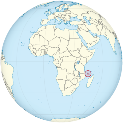
Comoros Location in World Map
Here you can see the location of the Comoros.
Location Information of Comoros
The Union of the Comoros is a small island nation located in the Indian Ocean, off the eastern coast of Africa, between Madagascar and the coast of Mozambique. Comprising three major islands—Grande Comore (Ngazidja), Anjouan (Ndzuwani), and Moheli (Mwali)—the country lies in a strategic maritime region, contributing to its historical importance in trade, culture, and politics. Comoros is part of the African Union and is situated in close proximity to several key global shipping routes, which have influenced its cultural exchanges over the centuries.
Latitude and Longitude
The Union of the Comoros is located at approximately 11.7° S latitude and 43.2° E longitude. The country’s islands are situated in the Mozambique Channel, between the northern part of Madagascar and the mainland of East Africa, at the southeastern edge of the African continent. Its geographical positioning places it within the tropics, and its proximity to other Indian Ocean islands, such as Réunion and Mauritius, gives it a distinctive oceanic and cultural identity.
Capital City and Major Cities
Capital City: Moroni
The capital city of Comoros is Moroni, located on the island of Grande Comore (Ngazidja). Moroni is the largest city in the country, with an estimated population of around 60,000 to 70,000 people. It serves as the political, administrative, and economic center of the nation. The city lies along the west coast of Grande Comore and offers picturesque views of the Indian Ocean and the dormant Mount Karthala, which is one of the most prominent geographical features of the island.
Moroni has a rich cultural heritage influenced by a blend of African, Arab, French, and Indian traditions, which is evident in the local architecture, cuisine, and languages. The city’s key landmarks include the Old Friday Mosque (Masjid al-Jumu’ah), built in the 15th century, and the Moroni National Museum, which houses exhibits on the country’s history and culture.
Major Cities
- Mutsamudu Mutsamudu is the second-largest city in Comoros, located on the island of Anjouan (Ndzuwani). It is the capital of Anjouan and an important port city. Mutsamudu has a population of around 30,000 to 40,000 people and plays a significant role in the country’s economy, particularly in agriculture and trade. The city is located on the northern coast of Anjouan, with narrow streets and historical buildings that reflect the island’s mixed cultural heritage.
- Fomboni Fomboni is the capital of Moheli (Mwali), the smallest island of the three in the Comoros. Located on the island’s west coast, Fomboni has a population of around 10,000 people. Although it is much smaller in terms of size and population compared to Moroni and Mutsamudu, Fomboni is an important center for the island’s administration and commerce. The city has a picturesque harbor and is known for its peaceful, laid-back atmosphere.
- Domoni Domoni is a small town located on the southern coast of Anjouan, known for its agriculture and fishing industries. The town’s economy is based on the production of cloves, vanilla, and ylang-ylang, which are significant exports of the Comoros. Domoni, like other coastal towns, relies heavily on the maritime economy, with ships docking at its port to export goods to other countries.
- Sima Sima is a smaller town located on Grande Comore. It is known for its proximity to the Mount Karthala volcano and has a population of around 7,000. Sima is a quiet agricultural area and serves as a base for exploring the Karthala Crater and nearby natural sites.
Time Zone
Comoros operates on East Africa Time (EAT), which is UTC +3 hours. This time zone is shared with several other East African countries, including Kenya, Tanzania, and Ethiopia. Unlike many other regions, Comoros does not observe Daylight Saving Time (DST), so the time remains constant throughout the year. The time zone helps synchronize business and communication between the Comoros and neighboring countries in the Indian Ocean and East Africa.
Climate
The climate of the Comoros is tropical, characterized by warm temperatures, high humidity, and significant rainfall, particularly during the rainy season. Due to the islands’ geographical location near the equator, Comoros experiences a relatively stable climate year-round, with temperatures rarely fluctuating dramatically.
Temperature
Average temperatures in the Comoros range from 24°C to 30°C (75°F to 86°F), with coastal areas generally being warmer and the highland regions being slightly cooler. Grande Comore has an active volcanic environment, with its central peaks, such as Mount Karthala, influencing local weather patterns. The presence of the mountains on Grande Comore and the forested interiors of Anjouan and Moheli contribute to the variability in temperature at different altitudes.
Rainfall
The rainy season in the Comoros typically lasts from November to April, with January to March receiving the heaviest rainfall. Rainfall averages 1,500 to 2,000 mm (59 to 79 inches) annually, depending on the region. Grande Comore, especially in the areas surrounding Mount Karthala, experiences more precipitation compared to the other islands. During the dry season, from May to October, rainfall is significantly reduced, leading to a relatively drier climate, especially on the eastern parts of the islands.
Humidity
The Comoros also experiences high humidity, which is characteristic of its tropical climate. The islands’ proximity to the Indian Ocean and the presence of lush vegetation contribute to this high moisture content in the air. Humidity levels tend to remain around 80% throughout the year, making the air feel warm and heavy.
Cyclones
Comoros is occasionally affected by tropical cyclones, particularly during the peak of the cyclone season, which runs from December to April. These storms can cause significant damage, especially in coastal areas. The government and local authorities are often on alert during this period to ensure the safety of the population.
Economic Status
The Comoros economy is primarily based on agriculture, fishing, and the export of natural resources. Despite its natural wealth, the country faces several economic challenges, including limited infrastructure, political instability, and reliance on external aid. The country has a relatively small GDP, and the poverty rate is high, with many Comorians relying on subsistence farming and fishing for their livelihoods.
Key Industries
- Agriculture Agriculture is the cornerstone of the Comoros economy, with the majority of the population engaged in farming. The main agricultural exports are spices, including vanilla, cloves, and ylang-ylang, as well as coconuts and bananas. Vanilla and cloves are the country’s most valuable exports and are used extensively in the fragrance and culinary industries worldwide. Ylang-ylang, a flower used in perfume production, is another important export commodity.
- Fishing Fishing is another vital sector of the economy. The islands’ exclusive economic zone (EEZ) in the Indian Ocean provides access to rich marine resources, including tuna and other fish species, which are exported to Asia and Europe. The fishing industry is growing and is supported by the Indian Ocean Tuna Commission.
- Tourism While tourism is not a major contributor to the national economy, it holds significant potential for the future. The Comoros’ natural beauty, including pristine beaches, volcanic mountains, and rich marine biodiversity, makes it an attractive destination for eco-tourism. Key attractions include Mount Karthala, the Mohéli Marine Park, and the island’s coral reefs. However, political instability and limited infrastructure have hindered the country’s ability to fully capitalize on its tourism potential.
- Oil and Gas Comoros has some potential for offshore oil and gas exploration, particularly in its exclusive economic zone. However, the country lacks the infrastructure and investment to fully develop these resources. Efforts have been made to attract foreign investment to boost the sector.
- Remittances Due to a significant diaspora community, particularly in France, remittances sent back home play a crucial role in the economy. Many Comorians live and work abroad, particularly in Europe and the Middle East, and send money back to support families in the islands.
Tourist Attractions
Comoros offers several natural and cultural attractions that appeal to eco-tourists, adventure travelers, and those seeking a unique cultural experience.
- Mount Karthala Mount Karthala is an active volcano located on Grande Comore. It is one of the largest volcanoes in the world and offers hiking and trekking opportunities for adventure seekers. The crater lake and surrounding landscapes are stunning, attracting tourists interested in volcanic activity and natural beauty.
- Mohéli Marine Park This marine park is a sanctuary for marine life, including sea turtles, dolphins, and whales. It is a protected area and offers some of the best snorkeling and diving experiences in the Indian Ocean. The park is part of efforts to conserve the rich biodiversity of the Comoros.
- Beaches and Coral Reefs The islands of the Comoros are surrounded by stunning beaches and coral reefs, making it a paradise for beach lovers and divers. Anjouan and Moheli are particularly known for their pristine beaches, offering opportunities for swimming, diving, and relaxing.
- Old Friday Mosque in Moroni The Old Friday Mosque in Moroni is one of the most historically significant sites in the Comoros. It is a place of worship and a testament to the country’s rich Islamic heritage.
- Udundi National Park Located on the island of Anjouan, this park is known for its dense forests, waterfalls, and unique flora and fauna. It is a great spot for trekking and wildlife viewing.
Visa Requirements for U.S. Citizens
U.S. citizens wishing to visit Comoros must obtain a visa. This can be done either on arrival at the airport or by applying for a visa through the Comorian embassy in the United States or neighboring countries. The visa typically requires:
- A valid passport (with at least six months of validity).
- Completed visa application form.
- Passport-sized photographs.
- Proof of return or onward travel.
- Visa fee.
In addition, travelers may need to show proof of yellow fever vaccination, as it is required for entry from certain countries.
Distance to Major U.S. Cities
- Distance to New York City The distance from New York City (JFK) to Moroni, the capital of Comoros, is approximately 8,500 miles (13,700 kilometers). Flight duration usually takes around 20 to 24 hours, with one or more layovers depending on the chosen airline.
- Distance to Los Angeles The distance from Los Angeles (LAX) to Moroni is approximately 9,000 miles (14,500 kilometers). A flight typically takes 20 to 22 hours, depending on the route and number of stopovers.
Comoros Facts
| Size | 1,862 km² |
| Residents | 794,678 |
| Languages | Comorian, French and Arabic |
| Capital | Moroni |
| Longest river | – |
| Highest mountain | Karthala (2,361 m) |
| Currency | Comoros Franc |


