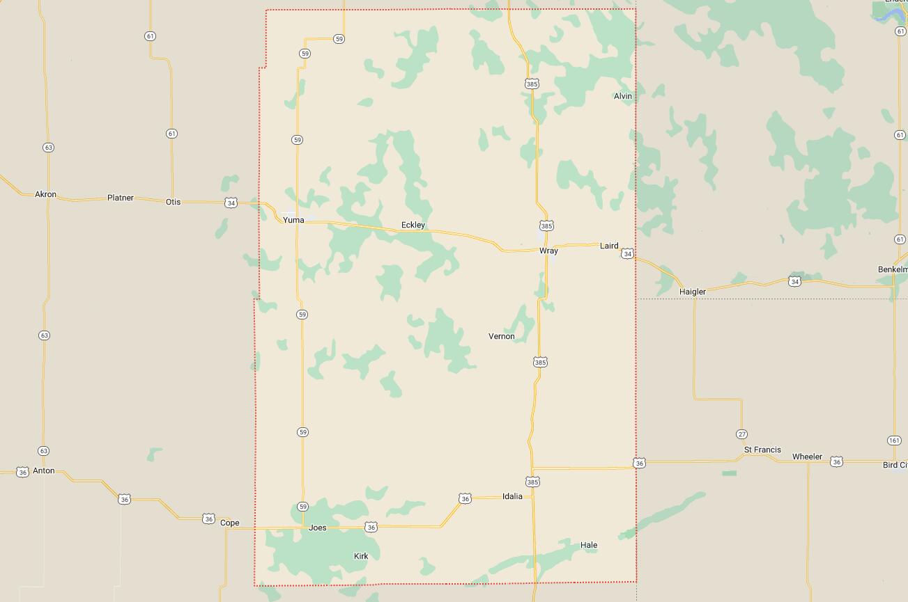
Cities and Towns in Yuma County, Colorado
Founded on 1889-03-15, Yuma County is one of 64 counties in the state of Colorado. Historically, Yuma County was split from Washington County. The city of Wray is the county seat. With FIPS code of 125, Yuma County has a population of 9,941 and area of 2,369.61 square miles (6,137 km²).
List of all cities in Yuma County, CO alphabetically
| City/Town | Postal Code | Area Code |
| Eckley, CO | 80727 | 970 |
| Hale, CO | 80735 | 970 |
| Idalia, CO | 80735 | 970 |
| Joes, CO | 80822 | 970 |
| Kirk, CO | 80824 | 970 |
| Laird, CO | 80758 | 970 |
| Vernon, CO | 80755 | 970 |
| Wray, CO | 80758 | 970 |
| Yuma, CO | 80759 | 970 |
Major Cities and Towns in Yuma County, Colorado
Yuma
Area, Population, and Geographic Coordinates
- Area: 2.2 square miles
- Population: Approximately 3,524 (as of 2020)
- Zip Codes: 80759
- Latitude: 40.1222° N
- Longitude: 102.7224° W
Location and History
Yuma is located in the northeastern part of Colorado, near the Nebraska border, and serves as one of the largest towns in Yuma County. The town was founded in the 1880s during the expansion of the railroad, which played a critical role in its development. Yuma was named after the Yuma Native American tribe, reflecting the area’s deep connections to indigenous cultures. The town quickly became a vital agricultural hub, with its fertile soil making it ideal for farming and ranching. Over the years, Yuma has maintained its agricultural roots, and today it is known for its strong community spirit and the preservation of its historical heritage. The town’s location along U.S. Route 34 provides easy access to larger cities while retaining a small-town atmosphere.
Major Schools and Landmarks
Yuma is served by the Yuma School District 1, with Yuma High School being the primary educational institution. The town features several notable landmarks, including the Yuma County Courthouse, an architectural gem that reflects the town’s rich history. The Indian Hills Golf Course, located just outside of town, provides a recreational outlet for both residents and visitors. Yuma also hosts an annual Harvest Festival, celebrating the town’s agricultural heritage with parades, fairs, and community events that draw people from across the region. The combination of historical significance and agricultural prosperity makes Yuma a central part of Yuma County’s identity.
Wray
Area, Population, and Geographic Coordinates
- Area: 3.5 square miles
- Population: Approximately 2,358 (as of 2020)
- Zip Codes: 80758
- Latitude: 40.0769° N
- Longitude: 102.2243° W
Location and History
Wray is located in the eastern part of Yuma County, near the Kansas border, and serves as the county seat. The town was established in the late 19th century as a stop along the Chicago, Burlington and Quincy Railroad. Wray was named after John Wray, an early settler who played a key role in the town’s development. The town quickly grew into an agricultural center, with its economy driven by farming, particularly wheat and corn, as well as cattle ranching. Over the years, Wray has retained its agricultural roots while developing into a modern community with a strong emphasis on education and local culture. The town’s location along U.S. Highway 34 makes it a convenient stop for travelers and a hub for local commerce.
Major Schools and Landmarks
Wray is served by the Wray School District RD-2, with Wray High School being the primary educational institution. The town is home to several notable landmarks, including the Wray Museum, which showcases the history of the area and its early settlers. Beecher Island, located nearby, is a significant historical site, marking the location of a famous battle between U.S. Army scouts and Native American warriors in 1868. The nearby Arikaree Breaks, a unique geological formation, offers scenic views and opportunities for hiking and photography. Wray’s rich history, combined with its agricultural and cultural contributions, makes it a vital part of Yuma County.
Eckley
Area, Population, and Geographic Coordinates
- Area: 0.3 square miles
- Population: Approximately 257 (as of 2020)
- Zip Codes: 80727
- Latitude: 40.1078° N
- Longitude: 102.4882° W
Location and History
Eckley is a small town located in the central part of Yuma County. The town was established in the early 20th century as a small farming community, with the Great Western Railway playing a significant role in its development. Named after a local pioneer family, Eckley has maintained its rural character throughout the years. The town’s economy has always been closely tied to agriculture, particularly the production of wheat and corn. Although small, Eckley has a rich history that reflects the broader story of rural development in Colorado. The town is known for its tight-knit community and its commitment to preserving the agricultural way of life that has sustained it for generations.
Major Schools and Landmarks
Eckley is served by the Yuma School District 1, with students typically attending schools in nearby Yuma or Wray. The town’s most notable landmark is the historic Eckley United Methodist Church, which has been a central part of the community for over a century. The surrounding farmland offers opportunities for hunting, particularly for pheasants, which are abundant in the area. The town’s rural atmosphere and commitment to agriculture make it a quintessential example of small-town life in eastern Colorado. Eckley’s history and community spirit are key aspects of its identity within Yuma County.
Vernon
Area, Population, and Geographic Coordinates
- Area: Not formally incorporated
- Population: Approximately 150 (estimated as of 2020)
- Zip Codes: 80755
- Latitude: 39.8705° N
- Longitude: 102.3919° W
Location and History
Vernon is a small, unincorporated community located in the southeastern part of Yuma County. The town was established in the late 19th century as a farming and ranching community, with settlers attracted by the fertile land and open spaces. Vernon’s development was closely tied to the agricultural industry, with wheat, corn, and cattle being the primary economic activities. Although the town has remained small, it has a rich history that reflects the broader patterns of settlement and agricultural development in northeastern Colorado. Vernon has retained its rural character, with a strong emphasis on community and traditional values.
Major Schools and Landmarks
Vernon is part of the Wray School District RD-2, with students typically attending schools in nearby Wray. The town’s most notable landmark is the Vernon Schoolhouse, a historic building that has served as a community center and gathering place for many years. The surrounding countryside offers opportunities for outdoor activities such as hunting and birdwatching, with the area known for its abundance of pheasants and other game birds. Vernon’s small-town atmosphere, agricultural heritage, and strong sense of community make it an integral part of Yuma County’s rural landscape.
Map of Cities in Yuma County, CO