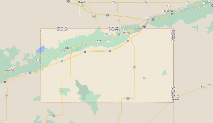
Cities and Towns in Sedgwick County, Colorado
Founded on 1889-04-09, Sedgwick County is one of 64 counties in the state of Colorado. Historically, Sedgwick County was split from Logan County. The city of Julesburg is the county seat. With FIPS code of 115, Sedgwick County has a population of 2,336 and area of 548.83 square miles (1,421 km²).
List of all cities in Sedgwick County, CO alphabetically
| City/Town | Postal Code | Area Code |
| Julesburg, CO | 80737 | 970 |
| Ovid, CO | 80744 | 970 |
| Sedgwick, CO | 80749 | 303/720 |
Major Cities and Towns in Sedgwick County, Colorado
Julesburg
Area, Population, and Geography
- Area: 1.4 square miles
- Population: Approximately 1,200 (2023 estimate)
- Zip Codes: 80737
- Latitude: 40.9891° N
- Longitude: 102.2649° W
City Location and History
Julesburg, the county seat of Sedgwick County, is located in the northeastern corner of Colorado, near the Nebraska border. The town was established in the mid-19th century as a stop along the Pony Express and later the Overland Stage Route. Named after Jules Beni, a notorious early settler who operated a trading post and stage station, Julesburg quickly became known for its Wild West reputation, including stories of outlaws and frontier justice. The original town of Julesburg was burned down during a raid by the Cheyenne in 1865, but it was rebuilt a few miles away and continued to thrive as a transportation hub. The arrival of the Union Pacific Railroad in the late 1860s solidified its importance as a key stop for travelers and trade in the region.
Major Schools and Landmarks
Julesburg is served by the Julesburg School District RE-1, with Julesburg High School being the primary educational institution in the town. The town’s major landmarks include the Fort Sedgwick Museum, which offers exhibits on the area’s history, including its role in the Pony Express, the Union Pacific Railroad, and the military outpost of Fort Sedgwick. The town also celebrates its heritage with the annual Julesburg Daze festival, which includes a parade, rodeo, and other community events. The nearby South Platte River provides opportunities for fishing, boating, and wildlife observation. Julesburg’s blend of historical significance, educational resources, and outdoor activities make it a key community in Sedgwick County.
Ovid
Area, Population, and Geography
- Area: 0.3 square miles
- Population: Approximately 300 (2023 estimate)
- Zip Codes: 80744
- Latitude: 40.9603° N
- Longitude: 102.3891° W
City Location and History
Ovid is a small town located in the northeastern part of Sedgwick County, just a few miles south of the Nebraska border. The town was founded in the early 20th century as an agricultural community, with its growth largely tied to the sugar beet industry. Ovid was home to one of the largest sugar beet processing factories in the region, operated by the Great Western Sugar Company. The factory played a central role in the town’s economy, providing jobs and supporting local agriculture. However, the closure of the sugar factory in the 1980s led to a decline in the town’s population and economic activity. Despite this, Ovid remains a tight-knit community with a strong sense of local pride.
Major Schools and Landmarks
Ovid is served by the Revere School District RE-2, with Revere Junior-Senior High School located in nearby Sedgwick. The town’s major landmarks include the old sugar beet factory, a reminder of Ovid’s industrial past, and the Ovid Town Hall, which serves as a community center for local events and meetings. The town also features several parks and open spaces that provide recreational opportunities for residents. Ovid’s small size and close-knit community atmosphere make it a unique and historically significant town in Sedgwick County.
Sedgwick
Area, Population, and Geography
- Area: 0.2 square miles
- Population: Approximately 150 (2023 estimate)
- Zip Codes: 80749
- Latitude: 40.9381° N
- Longitude: 102.5271° W
City Location and History
Sedgwick is a small town located in the western part of Sedgwick County, near the South Platte River. The town was established in the early 20th century as a farming community, with agriculture playing a central role in its development. Sedgwick’s location along the Union Pacific Railroad made it a convenient stop for transporting agricultural products, particularly grain and livestock, to larger markets. Over the years, Sedgwick has remained a small, rural community with a focus on farming and ranching. The town is named after Fort Sedgwick, a military outpost established in the area during the Indian Wars of the mid-19th century.
Major Schools and Landmarks
Sedgwick is also served by the Revere School District RE-2, with students attending Revere Junior-Senior High School, which serves the surrounding rural communities. The town’s major landmarks include the historic Sedgwick Depot, a reminder of the town’s railroad heritage, and the Sedgwick Community Center, which hosts local events and gatherings. The nearby South Platte River offers opportunities for fishing, birdwatching, and exploring the natural environment of the region. Sedgwick’s agricultural roots, historic significance, and tranquil rural setting make it a distinctive town in Sedgwick County.


