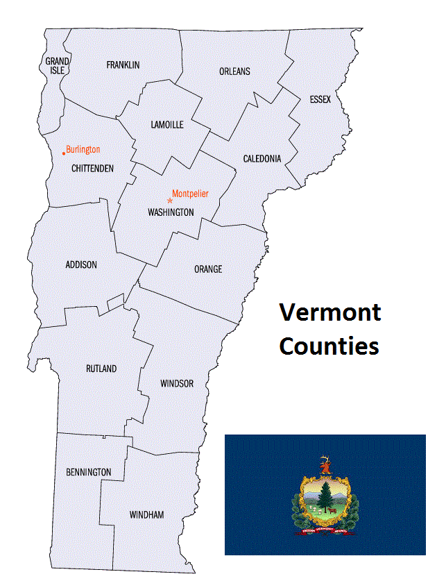
Vermont Counties. List Alphabetically (and by Population)
How many counties are there in Vermont? As of 2024, there are a total of 14 counties in the state of Vermont. Among them, Bennington County is the oldest one (established in 1779) while Lamoille County is the youngest (established in 1835). With population of 161,382, Chittenden County is the most populated. The biggest county by land area is Windsor County (2,515 km²) and the smallest is Grand Isle County (215 km²).
Largest Counties in Vermont
1. Windsor County
County Overview
- County Seat: Woodstock
- Area: 977 square miles
- Population: 57,753 (2020 Census)
- Area Codes: 802
- Latitude: 43.6218° N
- Longitude: 72.5185° W
Location and History
Windsor County is located in southeastern Vermont, bordered by New Hampshire to the east along the Connecticut River. Established in 1781, Windsor County is one of Vermont’s original counties. The county seat, Woodstock, is known for its picturesque New England charm and well-preserved historic buildings. Windsor, the town where Vermont was founded in 1777, served as the state’s first capital and is often referred to as the “Birthplace of Vermont.” The county’s history is steeped in the early settlement of Vermont, with agriculture and small-scale industry driving its economy. Over time, Windsor County became a center for tourism, with its scenic landscapes, historic sites, and vibrant communities attracting visitors year-round.
Major Highways and Landmarks
Interstate 91 and U.S. Route 4 are the major highways that run through Windsor County, providing crucial north-south and east-west connections. Major landmarks include the Marsh-Billings-Rockefeller National Historical Park, the only national park in Vermont, which preserves the legacy of conservation in America. The Quechee Gorge, known as Vermont’s Little Grand Canyon, is another key attraction, offering stunning views and hiking trails. The historic Woodstock Inn and Resort is a symbol of the county’s appeal as a tourist destination. Additionally, the American Precision Museum in Windsor showcases the county’s industrial heritage, particularly in the field of precision manufacturing.
2. Rutland County
County Overview
- County Seat: Rutland
- Area: 945 square miles
- Population: 60,572 (2020 Census)
- Area Codes: 802
- Latitude: 43.6106° N
- Longitude: 73.9722° W
Location and History
Rutland County is located in the central part of Vermont, encompassing a diverse landscape of mountains, valleys, and lakes. The county was established in 1781 and is named after Rutland in Massachusetts, from where many of its early settlers originated. Rutland, the county seat, grew rapidly in the 19th century due to the marble industry, which earned the city the nickname “Marble City.” The county’s economy historically centered on agriculture, mining, and manufacturing, with marble quarrying being particularly significant. Today, Rutland County balances its industrial heritage with a strong tourism sector, driven by its natural beauty and outdoor recreation opportunities.
Major Highways and Landmarks
U.S. Route 7 and U.S. Route 4 are the primary highways that serve Rutland County, providing access to Burlington, the Green Mountains, and other parts of Vermont. Major landmarks include Killington Resort, one of the largest ski resorts in the eastern United States, offering world-class skiing, snowboarding, and mountain biking. The Green Mountain National Forest, which covers a significant portion of the county, provides extensive trails for hiking, camping, and wildlife observation. Additionally, the Norman Rockwell Museum in Rutland showcases the works of the famous American illustrator, who lived in the county for many years.
3. Chittenden County
County Overview
- County Seat: Burlington
- Area: 619 square miles
- Population: 168,323 (2020 Census)
- Area Codes: 802
- Latitude: 44.4759° N
- Longitude: 73.2121° W
Location and History
Chittenden County is located in northwestern Vermont and is the most populous county in the state. The county was established in 1787 and named after Thomas Chittenden, the first Governor of Vermont. Burlington, the county seat, is Vermont’s largest city and serves as the cultural, economic, and educational hub of the state. The county’s history is marked by its strategic location along Lake Champlain, which facilitated trade and transportation in the early years of Vermont’s development. Burlington became a center for commerce, industry, and education, with the University of Vermont playing a significant role in shaping the city’s character. Today, Chittenden County is a dynamic mix of urban and rural landscapes, with a strong focus on sustainability and quality of life.
Major Highways and Landmarks
Interstate 89 and U.S. Route 2 are the major highways that run through Chittenden County, connecting it to Montreal, Boston, and other major cities in the region. Major landmarks include the Church Street Marketplace in Burlington, a vibrant pedestrian mall with shops, restaurants, and cultural events. The county is also home to the Shelburne Museum, one of the finest museums of American folk art and architecture in the country. Lake Champlain, which borders the county to the west, offers numerous recreational opportunities, including boating, fishing, and swimming. Additionally, the Ethan Allen Homestead, located in Burlington, preserves the legacy of Vermont’s Revolutionary War hero.
4. Franklin County
County Overview
- County Seat: St. Albans
- Area: 692 square miles
- Population: 49,402 (2020 Census)
- Area Codes: 802
- Latitude: 44.8107° N
- Longitude: 73.0833° W
Location and History
Franklin County is located in northwestern Vermont, bordering Canada to the north and Lake Champlain to the west. The county was established in 1792 and named after Benjamin Franklin, one of the Founding Fathers of the United States. St. Albans, the county seat, is known for its historic downtown and its role in the St. Albans Raid during the Civil War, the northernmost land action of the conflict. The county’s economy has traditionally been based on agriculture, particularly dairy farming, which continues to be a significant industry. Franklin County is also known for its rich cultural heritage, with a strong presence of French-Canadian influences due to its proximity to Quebec.
Major Highways and Landmarks
Interstate 89 and U.S. Route 7 are the primary highways that serve Franklin County, providing connections to Burlington, Montreal, and other parts of Vermont. Major landmarks include the Missisquoi National Wildlife Refuge, which offers excellent birdwatching, hiking, and canoeing opportunities along the shores of Lake Champlain. The county is also home to the St. Albans Historical Museum, which showcases the region’s history and heritage. Additionally, the annual Vermont Maple Festival, held in St. Albans, celebrates the county’s status as a leading producer of maple syrup, drawing visitors from across the region.
5. Caledonia County
County Overview
- County Seat: St. Johnsbury
- Area: 658 square miles
- Population: 30,233 (2020 Census)
- Area Codes: 802
- Latitude: 44.4193° N
- Longitude: 72.0152° W
Location and History
Caledonia County is located in northeastern Vermont, within the region known as the Northeast Kingdom. The county was established in 1792 and named after the Roman name for Scotland, reflecting the Scottish heritage of many of its early settlers. St. Johnsbury, the county seat, grew as a center of commerce and industry in the 19th century, particularly due to the Fairbanks Scale Company, which was one of the largest employers in the region. The county’s economy has historically been based on agriculture, manufacturing, and forestry, with tourism becoming increasingly important in recent years due to the county’s natural beauty and outdoor recreation opportunities.
Major Highways and Landmarks
Interstate 91 and U.S. Route 5 are the major highways that run through Caledonia County, providing connections to the Connecticut River Valley and Canada. Major landmarks include the Fairbanks Museum and Planetarium in St. Johnsbury, which offers exhibits on natural history, astronomy, and Vermont’s cultural heritage. The county is also home to the St. Johnsbury Athenaeum, a historic library and art gallery that is a National Historic Landmark. Additionally, the Kingdom Trails network, located in nearby Burke, is renowned for its world-class mountain biking trails, attracting outdoor enthusiasts from across the country.
6. Orleans County
County Overview
- County Seat: Newport
- Area: 721 square miles
- Population: 27,037 (2020 Census)
- Area Codes: 802
- Latitude: 44.9366° N
- Longitude: 72.2041° W
Location and History
Orleans County is located in the northern part of Vermont, also within the Northeast Kingdom. The county was established in 1792 and named after the city of Orléans in France, reflecting the influence of French culture in the region. Newport, the county seat, is situated on the shores of Lake Memphremagog, a large glacial lake that extends into Canada. The county’s history is closely tied to its natural resources, with logging, farming, and fishing being the primary economic activities in the 19th and early 20th centuries. Today, Orleans County is known for its rural landscapes, outdoor recreation, and strong sense of community.
Major Highways and Landmarks
Interstate 91 and U.S. Route 5 are the major highways that serve Orleans County, providing access to Canada, the Connecticut River Valley, and other parts of Vermont. Major landmarks include the Lake Memphremagog, which offers boating, fishing, and scenic views along its 31-mile length. The county is also home to the Jay Peak Resort, a popular ski and summer resort that attracts visitors year-round. Additionally, the Old Stone House Museum in Brownington preserves the history of the region, with exhibits on early Vermont life, including agriculture, education, and industry.
7. Addison County
County Overview
- County Seat: Middlebury
- Area: 808 square miles
- Population: 37,363 (2020 Census)
- Area Codes: 802
- Latitude: 44.0084° N
- Longitude: 73.1494° W
Location and History
Addison County is located in western Vermont, along the shores of Lake Champlain. The county was established in 1785 and named after Joseph Addison, an English essayist and politician. Middlebury, the county seat, is home to Middlebury College, one of the oldest and most prestigious liberal arts colleges in the United States. The county’s history is marked by its agricultural roots, with dairy farming being the dominant industry for much of its history. In the 19th century, the county also became known for its marble quarries, which provided stone for buildings across the United States. Today, Addison County is a blend of agricultural tradition and academic excellence, with a strong focus on sustainability and local food production.
Major Highways and Landmarks
U.S. Route 7 is the primary highway that runs through Addison County, connecting it to Burlington, Rutland, and other parts of Vermont. Major landmarks include the Middlebury College Museum of Art, which features collections of American, European, and Asian art. The county is also home to the Rokeby Museum in Ferrisburgh, a National Historic Landmark that was a key site on the Underground Railroad. Additionally, the Champlain Bridge, which connects Addison County to New York State, offers stunning views of Lake Champlain and the Adirondack Mountains.
8. Washington County
County Overview
- County Seat: Montpelier
- Area: 695 square miles
- Population: 58,504 (2020 Census)
- Area Codes: 802
- Latitude: 44.2590° N
- Longitude: 72.5761° W
Location and History
Washington County is located in central Vermont and is home to the state capital, Montpelier. The county was established in 1810 and named after George Washington, the first President of the United States. Montpelier is the smallest state capital in the United States by population, known for its historic architecture and vibrant cultural scene. The county’s history is closely tied to its role as the political center of Vermont, with the State House being one of the most significant landmarks in the state. In addition to government, the county’s economy has traditionally included agriculture, granite quarrying, and manufacturing.
Major Highways and Landmarks
Interstate 89 and U.S. Route 2 are the major highways that run through Washington County, providing crucial connections to Burlington, New Hampshire, and other parts of Vermont. Major landmarks include the Vermont State House, a stunning example of Greek Revival architecture, and the Vermont History Museum, both located in Montpelier. The county is also home to the Barre granite quarries, which have produced some of the finest granite in the world, and the associated Rock of Ages Visitors Center. Additionally, the county offers outdoor recreation opportunities at places like the Hunger Mountain Trail, popular for hiking and offering panoramic views of the Green Mountains.
9. Orange County
County Overview
- County Seat: Chelsea
- Area: 692 square miles
- Population: 28,837 (2020 Census)
- Area Codes: 802
- Latitude: 43.9903° N
- Longitude: 72.4476° W
Location and History
Orange County is located in central Vermont, known for its rural landscapes and historic villages. The county was established in 1781 and named after William of Orange, a Protestant king of England. Chelsea, the county seat, is a small town with a classic New England town green and historic buildings. The county’s history is tied to agriculture, particularly dairy farming and maple syrup production, which remain significant industries today. The area also has a rich history of small-scale industry, with several mills and factories operating in the 19th century. Orange County is characterized by its scenic beauty, traditional Vermont way of life, and close-knit communities.
Major Highways and Landmarks
Interstate 89 and U.S. Route 302 are the primary highways that serve Orange County, providing access to Montpelier, Hanover, and other parts of Vermont. Major landmarks include the Justin Morrill Homestead in Strafford, the home of the U.S. Senator who authored the Land Grant College Act, which established public universities across the United States. The county is also home to the Fairlee Drive-In Theater, one of the oldest continuously operating drive-in theaters in the country. Additionally, the town of Tunbridge is known for its annual World’s Fair, a traditional agricultural fair that has been held since 1867, attracting visitors from across New England.
10. Lamoille County
County Overview
- County Seat: Hyde Park
- Area: 464 square miles
- Population: 25,362 (2020 Census)
- Area Codes: 802
- Latitude: 44.5939° N
- Longitude: 72.6184° W
Location and History
Lamoille County is located in north-central Vermont, known for its mountainous terrain and outdoor recreation opportunities. The county was established in 1835 and named after the Lamoille River, which flows through the region. Hyde Park, the county seat, is a small town with a rich history and a picturesque setting. The county’s economy has traditionally been based on agriculture, logging, and small-scale manufacturing. In recent decades, tourism has become increasingly important, driven by the county’s proximity to popular ski resorts and natural attractions. Lamoille County is now a year-round destination for outdoor enthusiasts.
Major Highways and Landmarks
State Route 15 and State Route 100 are the major highways that run through Lamoille County, providing access to Stowe, Burlington, and other parts of Vermont. Major landmarks include Smugglers’ Notch Resort, a popular destination for skiing, snowboarding, and summer activities like hiking and mountain biking. The county is also home to the Trapp Family Lodge in Stowe, a resort founded by the family that inspired “The Sound of Music,” offering a unique blend of Austrian hospitality and Vermont charm. Additionally, the Lamoille River provides excellent opportunities for fishing, kayaking, and canoeing, making it a key feature of the county’s outdoor appeal.
List of All Counties in Vermont Alphabetically
Below please see all Vermont counties which are listed in alphabetical order.
- Addison County, VT
- Bennington County, VT
- Caledonia County, VT
- Chittenden County, VT
- Essex County, VT
- Franklin County, VT
- Grand Isle County, VT
- Lamoille County, VT
- Orange County, VT
- Orleans County, VT
- Rutland County, VT
- Washington County, VT
- Windham County, VT
- Windsor County, VT
Map of Vermont Counties