South Dakota Counties List

There are a total of 66 counties in the state of South Dakota. Among them, Bon Homme County is the oldest one (established in 1862) while Jones County is the youngest (established in 1916).  With population of 169,468, Minnehaha County is the most populated. The biggest county by land area is Meade County (8,990 km²) and the smallest is Clay County (1,067 km²).

Largest Counties in South Dakota

1. Meade County

County Overview

  • County Seat: Sturgis
  • Area: 3,482 square miles
  • Population: 29,852 (2020 Census)
  • Area Codes: 605
  • Latitude: 44.4264° N
  • Longitude: 103.5106° W

Location and History

Meade County is located in the western part of South Dakota, covering a vast area that includes part of the Black Hills. Established in 1889, the county was named after Fort Meade, which was named in honor of General George Meade, a Union general during the Civil War. Sturgis, the county seat, is world-renowned for the annual Sturgis Motorcycle Rally, which attracts hundreds of thousands of visitors each year. The county’s history is closely tied to the military and the expansion of the American West, with Fort Meade playing a key role in protecting settlers during the late 19th century. Meade County has a rich history of ranching and agriculture, which remain significant contributors to the local economy.

Major Highways and Landmarks

Interstate 90 is the major highway that runs through Meade County, providing vital east-west connections across South Dakota. U.S. Route 212 also crosses the county, offering access to rural communities and scenic landscapes. Major landmarks include the Black Hills National Forest, which covers a portion of the county and offers numerous opportunities for hiking, camping, and wildlife viewing. The Fort Meade Museum and Cavalry Post near Sturgis preserves the military history of the area, with exhibits on the life of soldiers and the fort’s role in the Indian Wars. Additionally, Bear Butte State Park is a significant cultural and religious site for Native American tribes, offering hiking trails and panoramic views of the surrounding plains.

2. Pennington County

County Overview

  • County Seat: Rapid City
  • Area: 2,784 square miles
  • Population: 109,222 (2020 Census)
  • Area Codes: 605
  • Latitude: 44.0805° N
  • Longitude: 103.2310° W

Location and History

Pennington County is located in the western part of South Dakota, in the heart of the Black Hills. Established in 1875, the county was named after John L. Pennington, the third governor of the Dakota Territory. Rapid City, the county seat, is the second-largest city in South Dakota and serves as a major hub for tourism, commerce, and education in the region. The county’s history is deeply tied to the discovery of gold in the Black Hills, which led to a rapid influx of settlers and the establishment of Rapid City as a key economic center. Pennington County is known for its stunning natural beauty, including iconic landmarks like Mount Rushmore and the Badlands.

Major Highways and Landmarks

Interstate 90 and U.S. Route 16 are the major highways that traverse Pennington County, providing crucial connections to Yellowstone, the Midwest, and other regions. Major landmarks include Mount Rushmore National Memorial, a symbol of American history and democracy, attracting millions of visitors each year. The county is also home to Badlands National Park, known for its dramatic landscapes, rich fossil beds, and diverse wildlife. Additionally, Custer State Park, located in the southern part of the county, offers scenic drives, hiking trails, and the chance to see bison, elk, and other wildlife in their natural habitat.

3. Custer County

County Overview

  • County Seat: Custer
  • Area: 1,559 square miles
  • Population: 8,318 (2020 Census)
  • Area Codes: 605
  • Latitude: 43.7662° N
  • Longitude: 103.5980° W

Location and History

Custer County is located in southwestern South Dakota, within the Black Hills region. The county was established in 1875 and named after General George Armstrong Custer, who led an expedition to the Black Hills that contributed to the Black Hills Gold Rush. Custer, the county seat, is one of the oldest towns in the Black Hills and serves as a gateway to the region’s many natural attractions. The county’s history is closely tied to the discovery of gold and the subsequent settlement of the area by miners and pioneers. Today, Custer County is known for its outdoor recreation opportunities and its role in preserving the natural beauty and history of the Black Hills.

Major Highways and Landmarks

U.S. Route 16 and State Route 89 are the major highways that run through Custer County, providing access to nearby national parks and historic sites. Major landmarks include the Crazy Horse Memorial, an enormous mountain carving dedicated to the Lakota leader, which is still under construction and is one of the largest sculptures in the world. The county is also home to Wind Cave National Park, known for its intricate cave systems and unique boxwork formations, as well as its above-ground bison herds and prairies. Additionally, Jewel Cave National Monument, located in the county, is the third-longest cave in the world, offering tours and educational programs about its geology and history.

4. Lawrence County

County Overview

  • County Seat: Deadwood
  • Area: 800 square miles
  • Population: 25,768 (2020 Census)
  • Area Codes: 605
  • Latitude: 44.3769° N
  • Longitude: 103.7156° W

Location and History

Lawrence County is located in the northern Black Hills region of South Dakota. The county was established in 1877 and named after Colonel John Lawrence, a prominent legislator in the Dakota Territory. Deadwood, the county seat, is famous for its wild west history and as the site of the Black Hills Gold Rush. The county’s history is closely tied to the discovery of gold in Deadwood Gulch, which attracted thousands of miners and led to the establishment of the legendary town of Deadwood. Lawrence County remains a popular destination for history enthusiasts and outdoor adventurers, with its well-preserved historic sites and scenic landscapes.

Major Highways and Landmarks

U.S. Route 14A and State Route 34 are the major highways that run through Lawrence County, providing access to Deadwood and the surrounding Black Hills. Major landmarks include the historic town of Deadwood, where visitors can explore the graves of Wild Bill Hickok and Calamity Jane at Mount Moriah Cemetery, or try their luck at one of the town’s many casinos. The county is also home to Spearfish Canyon, a stunning gorge known for its towering cliffs, waterfalls, and scenic drives. Additionally, Terry Peak Ski Area offers winter sports enthusiasts a chance to enjoy skiing and snowboarding in the heart of the Black Hills.

5. Butte County

County Overview

  • County Seat: Belle Fourche
  • Area: 2,266 square miles
  • Population: 10,243 (2020 Census)
  • Area Codes: 605
  • Latitude: 44.6711° N
  • Longitude: 103.8521° W

Location and History

Butte County is located in northwestern South Dakota, bordering Wyoming to the west. The county was established in 1883 and named after the numerous buttes in the region. Belle Fourche, the county seat, is known as the “Center of the Nation,” as it is the geographic center of the United States, including Alaska and Hawaii. The county’s history is closely tied to the cattle industry, with Belle Fourche serving as a major livestock shipping center in the late 19th and early 20th centuries. Butte County’s economy continues to be driven by agriculture, particularly cattle ranching, as well as tourism related to its historic sites and natural attractions.

Major Highways and Landmarks

U.S. Route 212 and U.S. Route 85 are the major highways that run through Butte County, providing access to Belle Fourche and the surrounding region. Major landmarks include the Geographic Center of the Nation Monument in Belle Fourche, which marks the official center of the United States. The county is also home to the Belle Fourche River, which offers opportunities for fishing, kayaking, and birdwatching. Additionally, the Tri-State Museum in Belle Fourche showcases the history of the region, including exhibits on the cattle industry, Native American culture, and the early pioneers who settled the area.

6. Oglala Lakota County

County Overview

  • County Seat: Hot Springs (Administrative)
  • Area: 2,097 square miles
  • Population: 13,672 (2020 Census)
  • Area Codes: 605
  • Latitude: 43.2355° N
  • Longitude: 102.3487° W

Location and History

Oglala Lakota County, formerly known as Shannon County, is located in the southwestern part of South Dakota and is part of the Pine Ridge Indian Reservation. The county was established in 1875 and is named after the Oglala Lakota, a prominent band of the Lakota Sioux. The administrative center of the county is in Hot Springs, but the Pine Ridge Reservation is the heart of the county, with Pine Ridge serving as the cultural and economic center. The county’s history is deeply tied to the Lakota people and their struggle to maintain their land, culture, and way of life in the face of European-American expansion. The Wounded Knee Massacre of 1890, one of the most tragic events in Native American history, occurred in this county.

Major Highways and Landmarks

U.S. Route 18 and State Route 407 are the major highways that provide access to Oglala Lakota County and the Pine Ridge Reservation. Major landmarks include the Wounded Knee Massacre Site, a National Historic Landmark that commemorates the tragic events of 1890 and serves as a place of remembrance and reflection. The county is also home to the Red Cloud Indian School, an important educational institution founded by the Lakota leader Red Cloud. Additionally, the Oglala Lakota College offers higher education opportunities for residents of the reservation and plays a key role in preserving and promoting Lakota culture and language.

7. Ziebach County

County Overview

  • County Seat: Dupree
  • Area: 1,971 square miles
  • Population: 2,413 (2020 Census)
  • Area Codes: 605
  • Latitude: 45.0454° N
  • Longitude: 101.6045° W

Location and History

Ziebach County is located in central South Dakota and is part of the Cheyenne River Indian Reservation. The county was established in 1911 and named after Frank Ziebach, an early settler and prominent political figure in the Dakota Territory. Dupree, the county seat, is a small town that serves as the administrative and cultural center of the county. Ziebach County is one of the least populated and most remote counties in South Dakota, with a landscape dominated by rolling prairies, buttes, and the Cheyenne River. The county’s history is closely tied to the Lakota Sioux, who have lived in the area for centuries, and to the ranching industry, which has been a mainstay of the local economy.

Major Highways and Landmarks

U.S. Route 212 and State Route 65 are the major highways that run through Ziebach County, providing connections to Dupree and the surrounding region. Major landmarks include the Cheyenne River, which offers opportunities for fishing, boating, and wildlife observation. The county is also home to the annual Dupree Pioneer Days, a local celebration that includes rodeos, parades, and cultural events that reflect the county’s ranching heritage and Native American traditions. Additionally, the county’s vast open spaces and remote location make it a prime area for stargazing and experiencing the natural beauty of the Great Plains.

8. Lyman County

County Overview

  • County Seat: Kennebec
  • Area: 1,643 square miles
  • Population: 3,718 (2020 Census)
  • Area Codes: 605
  • Latitude: 43.8994° N
  • Longitude: 99.8621° W

Location and History

Lyman County is located in central South Dakota, along the Missouri River. The county was established in 1873 and named after W.P. Lyman, a member of the Dakota Territorial Legislature. Kennebec, the county seat, is a small town that serves as the administrative and commercial center of the county. The county’s history is closely tied to the development of agriculture, particularly wheat and corn farming, as well as cattle ranching. The construction of the Oahe Dam on the Missouri River in the mid-20th century created Lake Oahe, which has become a major recreational and economic asset for the county.

Major Highways and Landmarks

Interstate 90 and U.S. Route 83 are the major highways that run through Lyman County, providing access to the county’s communities and to the Missouri River. Major landmarks include Lake Oahe, a large reservoir created by the Oahe Dam, which offers opportunities for boating, fishing, camping, and other outdoor activities. The county is also home to the Lyman County Historical Society Museum in Kennebec, which preserves the history of the region, including exhibits on early settlers, Native American culture, and the development of agriculture. Additionally, the county’s location along the Missouri River makes it a key area for waterfowl hunting and other wildlife-related activities.

9. Dewey County

County Overview

  • County Seat: Timber Lake
  • Area: 2,302 square miles
  • Population: 5,227 (2020 Census)
  • Area Codes: 605
  • Latitude: 45.4297° N
  • Longitude: 100.6684° W

Location and History

Dewey County is located in central South Dakota, primarily within the Cheyenne River Indian Reservation. The county was established in 1883 and named after William P. Dewey, a territorial politician. Timber Lake, the county seat, is a small town that serves as the administrative center of the county. The county’s history is deeply intertwined with the Lakota Sioux, who have lived in the area for centuries, and with the ranching industry, which has been a major economic activity since the late 19th century. Dewey County is characterized by its vast open spaces, rolling prairies, and the Missouri River, which forms the county’s eastern border.

Major Highways and Landmarks

U.S. Route 212 and State Route 63 are the major highways that run through Dewey County, providing access to Timber Lake and other parts of the county. Major landmarks include the Timber Lake & Area Museum, which offers exhibits on the history of the region, including Native American culture, early settlers, and the ranching industry. The county is also home to the Cheyenne River, which offers opportunities for fishing, boating, and wildlife observation. Additionally, the county’s location within the Cheyenne River Indian Reservation makes it an important cultural center for the Lakota Sioux, with numerous events and gatherings that celebrate Lakota heritage and traditions.

10. Corson County

County Overview

  • County Seat: McIntosh
  • Area: 2,529 square miles
  • Population: 4,086 (2020 Census)
  • Area Codes: 605
  • Latitude: 45.9226° N
  • Longitude: 101.3452° W

Location and History

Corson County is located in northern South Dakota, along the border with North Dakota. The county was established in 1909 and named after Dighton Corson, a justice of the South Dakota Supreme Court. McIntosh, the county seat, is a small town that serves as the administrative and commercial center of the county. The county’s history is closely tied to the Native American tribes of the region, particularly the Lakota Sioux, as well as to the development of agriculture and ranching. Corson County is one of the least populated counties in South Dakota, with a landscape dominated by rolling prairies, the Missouri River, and the Standing Rock Indian Reservation.

Major Highways and Landmarks

U.S. Route 12 and State Route 63 are the major highways that run through Corson County, providing access to McIntosh and the surrounding region. Major landmarks include the Standing Rock Indian Reservation, which is home to the Lakota and Dakota Sioux and offers a rich cultural heritage, including powwows, traditional ceremonies, and historical sites. The county is also home to the Grand River National Grassland, a vast area of public land that offers opportunities for hiking, camping, hunting, and wildlife observation. Additionally, the Sitting Bull Monument, located near Mobridge on the Missouri River, honors the great Lakota leader and serves as a site of historical and cultural significance.

List of All Counties in South Dakota

Below please see all South Dakota counties which are listed in alphabetical order.

  1. Aurora County, SD
  2. Beadle County, SD
  3. Bennett County, SD
  4. Bon Homme County, SD
  5. Brookings County, SD
  6. Brown County, SD
  7. Brule County, SD
  8. Buffalo County, SD
  9. Butte County, SD
  10. Campbell County, SD
  11. Charles Mix County, SD
  12. Clark County, SD
  13. Clay County, SD
  14. Codington County, SD
  15. Corson County, SD
  16. Custer County, SD
  17. Davison County, SD
  18. Day County, SD
  19. Deuel County, SD
  20. Dewey County, SD
  21. Douglas County, SD
  22. Edmunds County, SD
  23. Fall River County, SD
  24. Faulk County, SD
  25. Grant County, SD
  26. Gregory County, SD
  27. Haakon County, SD
  28. Hamlin County, SD
  29. Hand County, SD
  30. Hanson County, SD
  31. Harding County, SD
  32. Hughes County, SD
  33. Hutchinson County, SD
  34. Hyde County, SD
  35. Jackson County, SD
  36. Jerauld County, SD
  37. Jones County, SD
  38. Kingsbury County, SD
  39. Lake County, SD
  40. Lawrence County, SD
  41. Lincoln County, SD
  42. Lyman County, SD
  43. Marshall County, SD
  44. McCook County, SD
  45. McPherson County, SD
  46. Meade County, SD
  47. Mellette County, SD
  48. Miner County, SD
  49. Minnehaha County, SD
  50. Moody County, SD
  51. Oglala Lakota County, SD
  52. Pennington County, SD
  53. Perkins County, SD
  54. Potter County, SD
  55. Roberts County, SD
  56. Sanborn County, SD
  57. Spink County, SD
  58. Stanley County, SD
  59. Sully County, SD
  60. Todd County, SD
  61. Tripp County, SD
  62. Turner County, SD
  63. Union County, SD
  64. Walworth County, SD
  65. Yankton County, SD
  66. Ziebach County, SD

Map of South Dakota Counties
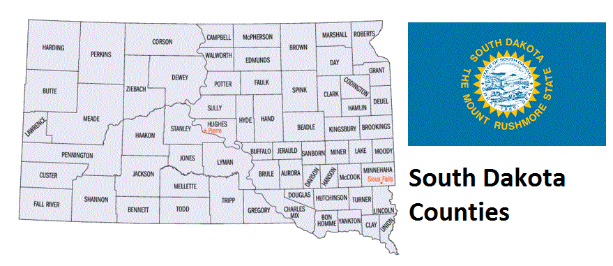
Map of South Dakota Counties