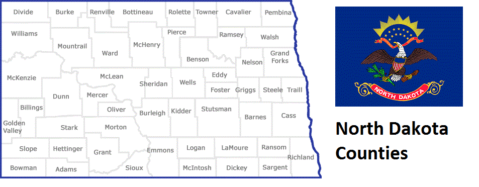
North Dakota Counties List
There are a total of 53 counties in the state of North Dakota. Among them, Pembina County is the oldest one (established in 1867) while Grant County is the youngest (established in 1916). With population of 149,778, Cass County is the most populated. The biggest county by land area is McKenzie County (7,102 km²) and the smallest is Eddy County (1,637 km²).
Largest Counties in North Dakota
1. McKenzie County
County Seat: Watford City
- Area: 2,861 square miles
- Population: Approximately 14,704 (2020 census)
- Area Codes: 701
- Latitude: 47.8025° N
- Longitude: 103.2839° W
Location and History
McKenzie County is the largest county in North Dakota by area, located in the western part of the state. Established on March 9, 1883, the county is named after Alexander McKenzie, a prominent North Dakota political figure. The county’s early history was shaped by its rugged terrain and its role as a frontier for early settlers. The discovery of oil in the Williston Basin significantly impacted the county’s development, leading to a population boom and economic growth, particularly in the 21st century. The area is also known for its stunning Badlands, which are part of the larger Theodore Roosevelt National Park.
Major Highways and Landmarks
McKenzie County is intersected by U.S. Highway 85, a major north-south route, and North Dakota Highway 23, which runs east-west. The county is home to portions of Theodore Roosevelt National Park, including the North Unit, which features breathtaking landscapes and abundant wildlife. Another notable landmark is the Maah Daah Hey Trail, a popular destination for hiking, biking, and horseback riding that showcases the scenic beauty of the Badlands. The confluence of the Missouri and Yellowstone Rivers near the county’s border is another significant geographic feature.
2. Williams County
County Seat: Williston
- Area: 2,148 square miles
- Population: Approximately 40,950 (2020 census)
- Area Codes: 701
- Latitude: 48.1478° N
- Longitude: 103.6170° W
Location and History
Williams County is located in the northwestern corner of North Dakota. It was established on December 8, 1891, and named after Erastus Appelman Williams, a political leader in the early history of the state. The county’s history is closely linked to agriculture, particularly wheat farming, and later, to the oil industry with the discovery of the Williston Basin. Williston, the county seat, became a central hub for the oil industry during the North Dakota oil boom, leading to rapid population growth and development. The county’s strategic location near the Montana and Canadian borders has also played a role in its economic and cultural history.
Major Highways and Landmarks
Williams County is served by U.S. Highway 2, which runs east-west across the northern United States, and U.S. Highway 85, a key north-south route. The county is home to the Fort Union Trading Post National Historic Site, which preserves the history of the fur trade era. Another significant landmark is Lake Sakakawea, one of the largest man-made lakes in the United States, offering recreational opportunities such as fishing, boating, and camping. Additionally, the Williston Basin offers insights into the geological and economic significance of the region’s oil reserves.
3. Mountrail County
County Seat: Stanley
- Area: 1,942 square miles
- Population: Approximately 10,961 (2020 census)
- Area Codes: 701
- Latitude: 48.2987° N
- Longitude: 102.3804° W
Location and History
Mountrail County is located in the northwestern part of North Dakota. It was established on January 4, 1873, and was named after Joseph Mountrail, a Métis fur trader. The county’s early economy was primarily based on agriculture, with wheat and barley as the main crops. However, the discovery of oil in the Williston Basin has transformed Mountrail County into a significant center for the oil industry, leading to increased economic activity and population growth. Stanley, the county seat, has evolved into a key community in the region, supporting the oil and agricultural industries.
Major Highways and Landmarks
Mountrail County is traversed by U.S. Highway 2, providing east-west access across the state, and North Dakota Highway 8, running north-south. The county is known for its proximity to Lake Sakakawea, particularly the Van Hook Arm, which is a popular location for fishing and boating. The Four Bears Bridge, connecting Mountrail and McKenzie counties, is another important landmark, offering scenic views of the lake and the surrounding landscape. Additionally, the county is home to portions of the Fort Berthold Indian Reservation, adding to its cultural significance.
4. Morton County
County Seat: Mandan
- Area: 1,945 square miles
- Population: Approximately 31,364 (2020 census)
- Area Codes: 701
- Latitude: 46.8260° N
- Longitude: 100.8892° W
Location and History
Morton County is situated in the south-central part of North Dakota, just west of the Missouri River. It was established on January 8, 1873, and was named after Oliver P. Morton, a governor of Indiana. The county’s history is deeply tied to the development of the Northern Pacific Railway, which facilitated settlement and economic growth in the area. Mandan, the county seat, was founded in 1879 as a railroad town and has since grown into a vibrant community. The county’s economy has traditionally been based on agriculture, with livestock and grain farming playing significant roles, although it has diversified in recent years.
Major Highways and Landmarks
Morton County is served by Interstate 94, which runs east-west across the state, and U.S. Highway 83, a major north-south route. The county is home to Fort Abraham Lincoln State Park, a historic site that includes the reconstructed home of General George Custer and an On-A-Slant Indian Village. The Missouri River, which forms the county’s eastern border, is another significant landmark, offering opportunities for boating and fishing. Additionally, the county hosts annual events such as the Mandan Rodeo Days, reflecting its cultural heritage.
5. Divide County
County Seat: Crosby
- Area: 1,294 square miles
- Population: Approximately 2,195 (2020 census)
- Area Codes: 701
- Latitude: 48.9363° N
- Longitude: 103.2971° W
Location and History
Divide County is located in the far northwestern part of North Dakota, bordering Canada. It was established on November 8, 1910, and its name reflects its location on the Continental Divide. The county’s early history was shaped by homesteading and agriculture, particularly wheat farming, which remains a key part of the local economy. The discovery of oil in the nearby Williston Basin also brought economic opportunities, though the county remains sparsely populated. Crosby, the county seat, serves as the administrative and commercial center of Divide County.
Major Highways and Landmarks
Divide County is accessible via U.S. Highway 85, which runs north-south through the western part of the county. Another important route is North Dakota Highway 5, which runs east-west. Key landmarks include the Writing Rock State Historic Site, which features ancient Native American petroglyphs, and the Divide County Museum in Crosby, which preserves the history of the area. Additionally, the county’s proximity to the Canadian border has historically influenced its cultural and economic interactions with neighboring regions.
6. Dunn County
County Seat: Manning
- Area: 2,082 square miles
- Population: Approximately 4,095 (2020 census)
- Area Codes: 701
- Latitude: 47.2341° N
- Longitude: 102.6124° W
Location and History
Dunn County is located in western North Dakota and was established on February 10, 1908. The county was named after John Piatt Dunn, a prominent early settler and businessman in the region. The county’s economy has traditionally been based on agriculture, with cattle ranching and grain farming as key industries. In recent decades, Dunn County has also become a significant area for oil production, contributing to its economic growth. Manning, the county seat, is a small community that serves as the administrative center for the county’s government.
Major Highways and Landmarks
Dunn County is traversed by North Dakota Highway 22, which runs north-south, and North Dakota Highway 200, an east-west route. The county is home to portions of the Little Missouri National Grassland, which offers outdoor recreation opportunities such as hiking, camping, and hunting. Other notable landmarks include the Killdeer Mountain Battlefield State Historic Site, which commemorates a significant conflict between the U.S. Army and the Sioux Nation in 1864. The county’s landscape is characterized by rolling prairies and rugged badlands, making it a scenic part of the state.
7. Stark County
County Seat: Dickinson
- Area: 1,338 square miles
- Population: Approximately 31,489 (2020 census)
- Area Codes: 701
- Latitude: 46.8797° N
- Longitude: 102.7855° W
Location and History
Stark County is located in southwestern North Dakota. It was established on February 10, 1879, and was named after General George Stark, a director of the Northern Pacific Railway. The county’s early history is closely tied to the development of the railroad, which brought settlers and economic growth to the area. Dickinson, the county seat, was founded as a railroad town and has grown into a regional hub for agriculture, manufacturing, and education. The discovery of oil in the nearby Bakken Formation has also contributed to the county’s economic development in recent years.
Major Highways and Landmarks
Stark County is served by Interstate 94, which runs east-west across the county, and U.S. Highway 85, a major north-south route. Notable landmarks include the Dickinson Museum Center, which features exhibits on the history and prehistory of the region, and the Ukrainian Cultural Institute, reflecting the county’s diverse heritage. The nearby Theodore Roosevelt National Park is another major attraction, offering stunning views of the Badlands and opportunities for outdoor activities. Additionally, Stark County hosts the annual Roughrider Days Fair and Expo, celebrating the area’s western heritage.
8. Burleigh County
County Seat: Bismarck
- Area: 1,668 square miles
- Population: Approximately 98,458 (2020 census)
- Area Codes: 701
- Latitude: 46.8083° N
- Longitude: 100.7837° W
Location and History
Burleigh County is located in the central part of North Dakota, with Bismarck as its county seat and the state capital. The county was established on January 4, 1873, and was named after Dr. Walter A. Burleigh, an Indian agent and territorial delegate. The county’s history is deeply intertwined with that of Bismarck, which grew rapidly after being selected as the capital of the Dakota Territory in 1883. Burleigh County has played a central role in North Dakota’s political, economic, and cultural life, with its economy historically based on government, education, and agriculture.
Major Highways and Landmarks
Burleigh County is well-served by Interstate 94, which runs east-west, and U.S. Highway 83, which runs north-south. The county is home to the North Dakota State Capitol, a significant landmark and the tallest building in the state. Other notable landmarks include Fort Abraham Lincoln, located just south of Bismarck, and the Missouri River, which offers various recreational opportunities. The Dakota Zoo and the North Dakota Heritage Center & State Museum are popular attractions in Bismarck, reflecting the county’s rich history and cultural significance.
9. Ward County
County Seat: Minot
- Area: 2,056 square miles
- Population: Approximately 69,919 (2020 census)
- Area Codes: 701
- Latitude: 48.2325° N
- Longitude: 101.2923° W
Location and History
Ward County is located in north-central North Dakota and was established on November 23, 1885. The county was named after Mark Ward, a prominent early settler. Minot, the county seat, was founded as a railroad town and became known as the “Magic City” due to its rapid growth. Ward County’s economy has historically been based on agriculture, with wheat and barley as the primary crops. However, the discovery of oil in the nearby Bakken Formation has significantly impacted the county’s economy, leading to population growth and increased development.
Major Highways and Landmarks
Ward County is served by U.S. Highway 2, which runs east-west, and U.S. Highway 83, which runs north-south. Minot is home to several significant landmarks, including the Scandinavian Heritage Park, which celebrates the area’s Scandinavian roots, and the Roosevelt Park Zoo. The county also hosts the annual North Dakota State Fair, attracting visitors from across the state. Additionally, Minot Air Force Base, located just north of Minot, is a major employer and plays a crucial role in the county’s economy and identity.
10. McLean County
County Seat: Washburn
- Area: 2,328 square miles
- Population: Approximately 9,771 (2020 census)
- Area Codes: 701
- Latitude: 47.2903° N
- Longitude: 101.0573° W
Location and History
McLean County is located in central North Dakota and was established on March 8, 1883. The county is named after John A. McLean, an early territorial legislator. Washburn, the county seat, was established in 1882 and has served as a key community in the region. The county’s history is closely linked to agriculture, with farming and ranching being the primary economic activities. The construction of the Garrison Dam in the mid-20th century transformed the county’s landscape and economy, creating Lake Sakakawea, one of the largest man-made lakes in the United States.
Major Highways and Landmarks
McLean County is accessible via U.S. Highway 83, which runs north-south through the county, and North Dakota Highway 200, which runs east-west. The county is home to significant landmarks such as Fort Mandan, where the Lewis and Clark Expedition wintered in 1804-1805, and the Knife River Indian Villages National Historic Site, which preserves the history of the Hidatsa people. Lake Sakakawea offers numerous recreational opportunities, including fishing, boating, and camping. The Garrison Dam, located within the county, is a critical infrastructure project that provides flood control, irrigation, and hydroelectric power to the region.
List of All Counties in North Dakota
Below please see all North Dakota counties which are listed in alphabetical order.
- Adams County, ND
- Barnes County, ND
- Benson County, ND
- Billings County, ND
- Bottineau County, ND
- Bowman County, ND
- Burke County, ND
- Burleigh County, ND
- Cass County, ND
- Cavalier County, ND
- Dickey County, ND
- Divide County, ND
- Dunn County, ND
- Eddy County, ND
- Emmons County, ND
- Foster County, ND
- Golden Valley County, ND
- Grand Forks County, ND
- Grant County, ND
- Griggs County, ND
- Hettinger County, ND
- Kidder County, ND
- LaMoure County, ND
- Logan County, ND
- McHenry County, ND
- McIntosh County, ND
- McKenzie County, ND
- McLean County, ND
- Mercer County, ND
- Morton County, ND
- Mountrail County, ND
- Nelson County, ND
- Oliver County, ND
- Pembina County, ND
- Pierce County, ND
- Ramsey County, ND
- Ransom County, ND
- Renville County, ND
- Richland County, ND
- Rolette County, ND
- Sargent County, ND
- Sheridan County, ND
- Sioux County, ND
- Slope County, ND
- Stark County, ND
- Steele County, ND
- Stutsman County, ND
- Towner County, ND
- Traill County, ND
- Walsh County, ND
- Ward County, ND
- Wells County, ND
- Williams County, ND