Where is Sierra Leone Located?
Where is Sierra Leone located on the map? Sierra Leone is an independent nation located in Western Africa. Check out the following images to see location of Sierra Leone on maps.
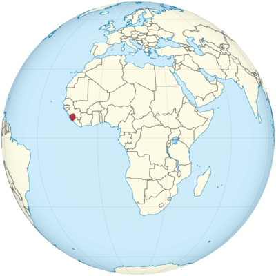
Sierra Leone Location in World Map
Location Information of Sierra Leone
Sierra Leone is a country located in West Africa, bordered by the Atlantic Ocean to the west, Guinea to the north and northeast, and Liberia to the southeast. It is known for its coastal beaches, natural resources, and vibrant culture. Sierra Leone has a diverse geography that includes mountains, rainforests, savannas, and a tropical climate. Despite facing challenges in recent history, the country is working toward economic recovery and development, becoming a destination for those interested in history, culture, and natural beauty.
Latitude and Longitude
Sierra Leone lies approximately at 8.4600° N latitude and 13.2340° W longitude. This position places it within the tropical zone of West Africa, bordering the Atlantic Ocean.
Capital City and Major Cities
Capital City: Freetown
The capital city of Sierra Leone is Freetown, located on the country’s Atlantic coastline. Freetown is the largest city in Sierra Leone and serves as the political, cultural, and economic center of the country. It is also the main harbor and port city, crucial for both domestic and international trade. Freetown was founded in 1787 by the British as a settlement for freed slaves, and this history is still celebrated today.
- Coordinates: 8.4650° N, 13.2317° W
- Population: Approximately 1.2 million people
Freetown is known for its picturesque setting, with hills and beaches surrounding the bay. The city has a mix of colonial architecture and modern buildings and serves as the primary gateway for international visitors to Sierra Leone. Major points of interest in Freetown include Cotton Tree, King’s Yard Gate, and the National Railway Museum.
Major Cities
While Freetown is the capital and largest city, there are several other significant towns and cities in Sierra Leone, each with its own importance for regional development:
- Bo
Bo is the second-largest city in Sierra Leone and is located in the southern part of the country. It is an important agricultural and commercial hub, known for its vibrant market scene.- Coordinates: 7.9760° N, 12.0400° W
- Kenema
Kenema is situated in the eastern part of Sierra Leone, known for its production of coffee, cocoa, and palm oil. The city is surrounded by fertile lands and serves as a trade center for agricultural products.- Coordinates: 7.6283° N, 11.1897° W
- Makeni
Makeni is located in the northern part of Sierra Leone and is a major commercial center. The city serves as a regional hub for trade, especially in agricultural goods.- Coordinates: 8.8833° N, 12.0500° W
- Koidu
Koidu, located in the eastern region of Sierra Leone, is the capital of the Kono District. It is a major mining town, with significant diamond mining activities that contribute to the country’s economy.- Coordinates: 8.5460° N, 11.1800° W
Time Zone
Sierra Leone operates in the Greenwich Mean Time (GMT) zone, with no daylight saving time. It follows GMT/UTC +0:00 throughout the year.
- Time difference with New York City: Sierra Leone is 5 hours ahead of New York City when New York is on standard time, and 4 hours ahead during daylight saving time.
- Time difference with Los Angeles: Sierra Leone is 8 hours ahead of Los Angeles when Los Angeles is on standard time and 7 hours ahead during daylight saving time.
Climate
Sierra Leone has a tropical climate, characterized by two main seasons: the wet season and the dry season. The climate varies by region, with coastal areas being humid and hot, while the interior experiences more temperature variation.
Wet Season
- The wet season lasts from May to October and is marked by heavy rainfall, particularly along the coast. This is when the country receives the majority of its annual rainfall, with July and August being the peak of the rainy season.
- Average rainfall: Coastal areas can experience up to 4,000 mm (157 inches) of rain annually.
- Temperature: Temperatures during the wet season are generally high, ranging from 24°C to 30°C (75°F to 86°F).
Dry Season
- The dry season occurs from November to April, with lower humidity and less rainfall. The dry season is influenced by the Harmattan winds, which bring dry, dusty air from the Sahara Desert.
- Average temperature: Temperatures during the dry season can range from 20°C to 31°C (68°F to 88°F).
The climate in Sierra Leone is ideal for tropical vegetation, including rainforests, mangroves, and savannas.
Economic Status
Sierra Leone has a mixed economy, with agriculture, mining, and services being key sectors of the economy. The country has faced significant economic challenges, particularly following the civil war (1991-2002), but is working towards rebuilding and diversifying its economic base.
Key Sectors of the Economy
- Agriculture: Agriculture is the largest sector of Sierra Leone’s economy, employing the majority of the population. Major crops include rice, cassava, palm oil, and cocoa. Sierra Leone has favorable climatic conditions for farming, although the sector still faces challenges related to infrastructure and access to markets.
- Mining: Sierra Leone is rich in natural resources, particularly diamonds, gold, and bauxite. The country’s diamond mining industry is particularly significant, though it has faced challenges related to illegal mining and conflict diamonds.
- Services and Tourism: The services sector, particularly tourism, is a growing contributor to Sierra Leone’s economy. The country is known for its beautiful beaches, natural parks, and historical sites. Tourism infrastructure is gradually improving, attracting international visitors for cultural experiences, eco-tourism, and beach holidays.
- Manufacturing: Although relatively underdeveloped, Sierra Leone’s manufacturing sector is growing, with industries related to food processing, textiles, and construction materials.
Despite efforts to diversify, Sierra Leone remains heavily dependent on exports of primary commodities. The country is working on strengthening its economic resilience through investment in infrastructure, human capital, and industries like agriculture and tourism.
Tourist Attractions
Sierra Leone has many attractions for tourists interested in history, culture, and nature. The country is rich in historical landmarks, pristine beaches, and wildlife, making it an emerging destination for travelers seeking an authentic West African experience.
1. Tokeh Beach
Tokeh Beach is one of Sierra Leone’s most popular coastal destinations, known for its stunning white sand, clear waters, and scenic views. It is located about 30 kilometers from Freetown and is perfect for a relaxing beach getaway.
- Coordinates: 7.7732° N, 12.6552° W
2. Bunce Island
Bunce Island, located off the coast of Sierra Leone, is a UNESCO World Heritage Site that served as a major slave trade post during the 18th century. Visitors can explore the ruins and learn about the dark history of the transatlantic slave trade.
- Coordinates: 7.5647° N, 13.0554° W
3. Kakum National Park
Kakum National Park is a beautiful rainforest reserve located near Freetown. It is home to a variety of flora and fauna, including elephants, monkeys, and hundreds of bird species. Visitors can take guided tours and enjoy canopy walks above the forest floor.
- Coordinates: 8.4990° N, 13.0080° W
4. Gola Rainforest National Park
This is one of Sierra Leone’s largest and most biodiverse protected areas, covering over 71,000 hectares. The park is known for its unique wildlife, including endangered species such as the western chimpanzee. It is a popular destination for eco-tourists and researchers.
- Coordinates: 7.6443° N, 11.5997° W
5. Tacugama Chimpanzee Sanctuary
The Tacugama Chimpanzee Sanctuary, located in the western peninsula, works to protect the endangered western chimpanzee. The sanctuary provides educational programs for visitors and is a significant conservation effort for primates in Sierra Leone.
- Coordinates: 8.3734° N, 13.1147° W
Visa Requirements for U.S. Citizens
U.S. citizens traveling to Sierra Leone are required to obtain a visa before arrival. The visa can be obtained through the Sierra Leone Embassy or Consulate. Additionally, visitors must present a valid U.S. passport, with at least six months validity beyond their intended stay. The visa process typically requires submission of travel documents, a passport-sized photo, and proof of onward travel.
Distance to New York City and Los Angeles
- New York City to Freetown: The distance between New York City and Freetown is approximately 7,300 kilometers (4,500 miles). Direct flights are rare, but one can expect flight durations of around 9-10 hours with one or more layovers.
- Los Angeles to Freetown: The distance between Los Angeles and Freetown is approximately 12,200 kilometers (7,600 miles). Flights typically require a 14-16 hour journey with layovers.
Sierra Leone Facts
| Size | 71,740 km² |
| Residents | 7.65 million |
| Language | English (official language) |
| Capital | Freetown |
| Longest river | Rokel (386 km) |
| Highest mountain | Bintumani (1,948 m high) |
| Currency | Leone |


