Where is Mali Located?
Where is Mali located on the map? Mali is an independent nation located in Western Africa. Check out the following images to see location of Mali on maps.
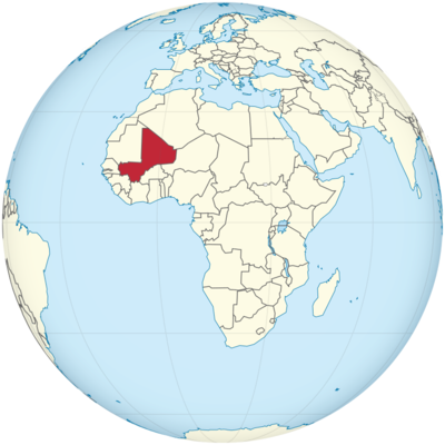
Mali Location in World Map
Mali is in West Africa. Mali borders Algeria in the northeast. There are further borders in the east with Niger, in the south with Burkina Faso and Ivory Coast, in the west with Guinea, Senegal and Mauritania. Mali has no access to the sea, it is a landlocked country.
On the map you can see: Mali is in West Africa.
Location Information of Mali
Latitude and Longitude
Mali is a landlocked country located in West Africa. Its geographic coordinates are approximately 12.6392° N latitude and 8.0029° W longitude. The country stretches across the western Sahara Desert and the Sahel region, making it a central part of the African continent.
Capital City and Major Cities
Capital City: Bamako
The capital of Mali is Bamako, situated on the Niger River in the southwestern part of the country. It is not only the political and administrative center of Mali but also the largest city in the country, with a population of over 2 million people. Bamako serves as the focal point for commerce, education, and culture in Mali.
Major Cities
- Ségou: Located in the central part of the country, Ségou is known as a historical and cultural center. It is the second-largest city in Mali and an important regional hub.
- Mopti: Often called the “Venice of Mali,” Mopti is a major port city located at the confluence of the Niger and Bani Rivers. It serves as an important trade and transport center in Mali.
- Kayes: Situated in the western part of Mali, Kayes is an important town, often serving as a crossroads for trade between Mali, Senegal, and Guinea.
- Tombouctou (Timbuktu): Located in the northern part of Mali, Timbuktu is a UNESCO World Heritage Site and was historically an important center of trade and Islamic scholarship.
- Koulikoro: A city located to the northwest of Bamako, Koulikoro is known for its role in agriculture, particularly cotton cultivation.
Time Zone
Mali operates on Greenwich Mean Time (GMT) year-round. The country does not observe daylight saving time, which means the time remains consistent throughout the year.
Climate
Mali has a predominantly hot desert climate with some variations across the regions. The climate is characterized by long, dry seasons, particularly in the northern and central parts of the country, which lie within the Saharan and Sahelian zones.
- Northern Mali: This region experiences a harsh desert climate, with scorching hot temperatures in the summer months and cooler temperatures in the winter. The region receives little to no rainfall throughout the year.
- Central Mali: The central region, including areas around Mopti and Ségou, experiences a semi-arid climate. Rainfall is more frequent in the summer, but the area still remains largely dry.
- Southern Mali: The southern part of the country, especially around Bamako, experiences a more tropical climate with a rainy season from June to September. This region can receive a significant amount of rainfall, which supports agriculture.
Mali’s annual average temperature ranges from 28°C to 35°C (82°F to 95°F), with the hottest months occurring between March and May. The rainy season, while brief, is crucial for local agriculture.
Economic Status
Mali is one of the least developed countries in the world, with a largely agrarian economy. The country is heavily dependent on agriculture, mining, and foreign aid. Some key aspects of Mali’s economic situation include:
Agriculture
Mali’s economy is largely based on agriculture, with crops like cotton, millet, maize, and rice forming the backbone of the agricultural sector. Cotton is Mali’s largest export commodity, and the country is one of Africa’s leading cotton producers. Rice and millet are staple foods grown within the country.
Mining
Mali is one of Africa’s largest gold producers, and gold mining constitutes a significant portion of its economy. Gold exports contribute significantly to Mali’s GDP and provide a source of foreign currency. The mining industry also includes significant deposits of other minerals such as salt and limestone.
Services and Trade
The service sector in Mali is growing, with Bamako serving as the major economic hub. Mali’s economy is also highly dependent on trade, with exports directed mainly to France, China, and other African nations. Livestock and textiles are also key exports. However, trade infrastructure is limited due to the country’s landlocked status.
Poverty and Challenges
Despite its agricultural and mining potential, Mali faces challenges like political instability, drought, and poverty. The country has one of the lowest Human Development Index (HDI) scores in the world, with a large proportion of the population living below the poverty line. Education and healthcare services are limited, which contributes to the overall economic challenges.
Tourist Attractions
Mali is rich in cultural heritage, and its landscape offers a unique blend of natural beauty and historical landmarks. Here are some of Mali’s most prominent tourist attractions:
1. Timbuktu
Timbuktu is one of the most famous historical cities in Africa. Known as the “City of 333 Saints,” Timbuktu was a major center of trade, culture, and Islamic scholarship during the medieval period. Today, it is home to ancient mosques, libraries, and manuscripts, which are UNESCO World Heritage sites. Though political instability has affected tourism in recent years, it remains a bucket-list destination for those interested in African history and Islamic heritage.
2. Djenné
Djenné is another UNESCO World Heritage Site and is known for the Great Mosque of Djenné, the largest mud-brick building in the world. The mosque and the city itself have significant historical and architectural importance.
3. The Niger River
The Niger River runs through Mali, and its banks are home to several unique wildlife and cultural experiences. Boat trips along the river, especially near cities like Mopti, provide tourists with scenic views and a look at local life along the riverbanks.
4. Bandiagara Escarpment
This UNESCO World Heritage Site is located in the Dogon Country, a region famous for its unique cliffside villages and rich cultural traditions. The Bandiagara Escarpment offers breathtaking views and insight into the unique architecture and customs of the Dogon people.
5. Famous Markets
Mali’s bustling markets, such as those in Bamako, Mopti, and Ségou, are vibrant with local crafts, textiles, spices, and other goods. These markets provide a chance to experience Mali’s culture firsthand and purchase unique souvenirs.
Visa Requirements for U.S. Citizens
U.S. citizens traveling to Mali require a visa to enter the country. The process of obtaining a visa typically involves the following steps:
- Application Form: U.S. citizens must complete a visa application form, available online or at the Embassy of Mali.
- Passport: A valid U.S. passport with at least six months of validity beyond the intended stay is required.
- Photographs: Two passport-sized photographs.
- Travel Itinerary: A copy of the flight itinerary and proof of accommodation.
- Yellow Fever Vaccination: Proof of a Yellow Fever vaccination is required for entry into Mali.
- Visa Fees: Fees vary depending on the type and duration of the visa.
Visas can be obtained through the Embassy of Mali in Washington, D.C., or via consulates in certain other cities. Travelers are advised to apply for their visas well in advance of their trip.
Distance to New York City and Los Angeles
Distance to New York City
The distance from New York City to Bamako, Mali, is approximately 5,400 miles (8,690 kilometers). This distance is based on a straight-line or great circle measurement. Direct flights are not common, and most travelers will have to make at least one stopover, typically in European cities such as Paris.
Distance to Los Angeles
The distance from Los Angeles to Bamako is roughly 6,200 miles (9,980 kilometers). As with flights to New York, travelers typically have to make one or more stops, often in Paris or other major European or African hubs, to reach Mali.
The distances and flight times to Mali indicate that the country is quite distant from the United States, requiring long-haul flights and multiple layovers for most routes.
Mali Facts
| Size | 1,240,192 km² |
| Residents | 19.07 million |
| Languages | French (official language), as well as Bambara and 34 other languages |
| Capital | Bamako |
| Longest river | Niger (in Mali 1,693 km) |
| Highest mountain | Hombori Tondo (1,153 m) |
| Currency | CFA franc |


