Mali Facts
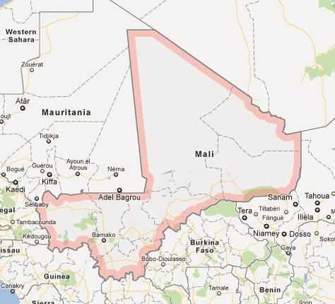
Mali, State of West Africa; 1.2 million km², 19.1 million residents (2019).Mali borders Algeria in the northeast, Niger in the east, Burkina Faso in the southeast, Ivory Coast in the south, Guinea in the southwest and Senegal and Mauritania in the west. The capital is Bamako (1.8 million residents, 2010).
Country facts
- Republic of Mali / Republic of Mali
- Country abbreviation: ML
- Area: 1.2 million km²
- Population (2019): 19.1 million residents
- Capital: Bamako
- Main languages: French, Bamboo
- State: Republic
- Head of State: Ibrahim Boubacar Keita (President)
- Head of Government: Boubou Cissé
- Per capita GDP (2018): US $ 901
- GNI per capita (2018): US $ 830
- Currency unit: 1 CFA franc = 100 centimes
- Currency code: XOF
- Country number (telephony): 223
- Internet Domain Name: ml
- Time difference compared to Sweden: −1
- National Day: September 22 (Proclamation of the Republic, 1960)
Nature
- Land use: forest (6%), agricultural land (4%), other (mainly desert, 90%)
- Highest mountain: Hombori Tondo (1,155 m above sea level)
Population
- Population density (2019): 16 residents per km²
- Natural population growth (2019): 3.6%; birth number 46 ‰, death number 10 ‰
- Age structure (2019): 0-14 years (48%), 15-64 (49%), 65- (3%)
- Life expectancy (2019): men 58 years, women 63 years
- Infant mortality (2019): 54 per 1,000 live births
- Population forecast 2050: 47 million residents
- HDI (2017): 0.427 (place 182 of 189)
- Urbanization rate (2019): 42%
- Most populous city (2010): Bamako (1.8 million residents)
Business
- Industry’s contribution to GDP (2017): agriculture (42%), industry (18%), service (40%)
- Exports of goods (2017): US $ 3,060 million
- Main export products: cotton, gold, cattle
- Main exporting countries: Switzerland, United Arab Republic, Burkina Faso
- Imports of goods (2017): US $ 3 644 million
- Main import products: oil, machinery, food
- Main importing countries: Senegal, China, Ivory Coast
- Railway network (2014): 600 km
Geography of Mali
Location and Boundaries
Mali is a landlocked country located in West Africa. It shares borders with seven countries: Algeria to the north, Niger to the east, Burkina Faso to the southeast, Côte d’Ivoire to the south, Guinea to the southwest, Senegal to the west, and Mauritania to the northwest. Mali covers an area of about 1.24 million square kilometers, making it the eighth-largest country in Africa. The country lies within the Sahel region, a transitional zone between the Sahara Desert to the north and the more humid tropical regions to the south.
Terrain and Landscape
The geography of Mali is characterized by vast expanses of desert, savannah, and wetlands. The northern region of Mali is dominated by the Sahara Desert, where sand dunes, rocky plateaus, and a harsh climate prevail. As one moves south, the landscape transitions into the Sahel, a semi-arid region with more vegetation and seasonal rainfall, supporting agriculture and livestock farming.
The southern part of Mali is much more fertile, with the Niger River playing a crucial role in the country’s agriculture and economy. The river, which flows through the country from the west to the east, provides water and fertile soil for crop cultivation. Along the riverbanks, there are lush floodplains and wetlands, particularly in the inner Niger Delta, an area known for its biodiversity.
Mali is also home to some notable geographical features, including the Adrar des Ifoghas mountain range in the north, which is part of the greater Saharan plateau. These mountains offer a striking contrast to the surrounding desert and are rich in both natural resources and history.
Rivers and Lakes
Mali is heavily dependent on its rivers for transportation, agriculture, and water supply. The Niger River, one of the major rivers in Africa, flows through the country, providing essential water resources for millions of people. The river’s basin is the country’s agricultural heartland, particularly in the region of the Inner Niger Delta. Alongside the Niger, the Senegal River forms a natural boundary with Mauritania and is crucial for both agricultural irrigation and trade.
Lakes and smaller rivers are also found in Mali, particularly in the southern regions, where the climate is more conducive to agriculture. The Lake of Bamako, located near the capital, is one such important water body for local ecosystems and water supply.
Climate of Mali
Hot and Dry Climate
Mali experiences a primarily hot and dry climate, characteristic of much of the Sahel region. The northern part of the country, which is dominated by the Sahara Desert, has a desert climate with extremely hot temperatures during the day and cool nights. The Sahara region experiences very little rainfall, making it a harsh environment for agriculture and settlement.
The central and southern parts of Mali have a more moderate climate, with a seasonal tropical savanna climate. These areas receive more rainfall, particularly during the rainy season from May to October, although the amounts can vary significantly between regions. The rainy season brings some relief from the extreme heat, but it is often short and irregular, resulting in periods of drought.
The Sahel and Desertification
Mali lies at the heart of the Sahel, an ecologically sensitive region that stretches across northern Africa. The Sahel experiences a delicate balance between desertification and occasional periods of rainfall. Deforestation, climate change, and overgrazing by livestock have contributed to desertification, particularly in the northern regions of Mali, making land less productive and exacerbating food insecurity. The government has taken various measures to combat desertification, including reforestation and sustainable land management programs, but challenges remain.
Temperature Extremes
Mali’s climate is characterized by extremes in temperature. In the Sahara and Sahel regions, daytime temperatures can reach over 40°C (104°F) during the hottest months of May and June, while temperatures can drop significantly at night. In the southern regions, the temperatures are somewhat milder, though still high, especially in the dry season. The rainy season in the south brings cooler temperatures but also high humidity, creating a more tropical climate in this region.
People of Mali
Population and Demographics
Mali has a population of approximately 21 million people, making it one of the most populous countries in West Africa. The population density is unevenly distributed, with the majority of people living in the southern and central regions, especially along the Niger River. The northern and more arid areas are sparsely populated due to the harsh climate and limited resources.
The population is predominantly rural, with about 70% of Malians living in rural areas, engaging in agriculture, livestock farming, and small-scale trading. Urbanization is increasing, however, with Bamako, the capital and largest city, being a major center of government, culture, and commerce. Other notable cities include Sikasso, Kayes, and Mopti, which serve as regional hubs for trade and services.
Ethnicity and Languages
Mali is a multiethnic country, home to over 20 ethnic groups. The largest ethnic group is the Bambara, who make up about 35% of the population. Other significant ethnic groups include the Fulani, Dogon, Tuareg, and Songhai. Each ethnic group has its own distinct language, customs, and traditions, although French is the official language of Mali.
Bambara is the most widely spoken indigenous language, particularly in the central and southern regions, and serves as a lingua franca for many of the country’s ethnic groups. Fulani, Dogon, and Songhai are also spoken in various regions, with each group contributing to the rich cultural diversity of Mali.
Mali’s ethnic groups maintain strong cultural traditions, with each group having its own languages, clothing, music, and religious practices. Despite ethnic diversity, the people of Mali have a shared sense of national identity and cultural pride.
Religion and Beliefs
Islam is the predominant religion in Mali, with around 90% of the population identifying as Muslim. Islam has been a significant cultural force in Mali for centuries, having been introduced to the region in the 11th century. Mali is a largely Sunni Muslim country, although there is also a small minority of Shia Muslims and practitioners of traditional African religions, particularly in rural areas.
Islamic practices such as fasting during Ramadan, daily prayers, and religious holidays like Eid al-Fitr and Eid al-Adha are integral to life in Mali. Islam has shaped much of the country’s social and political culture, with many religious leaders holding significant influence in their communities.
Traditional African religions are practiced by some ethnic groups, particularly in the rural areas, where animism and ancestor worship continue to play a role in cultural and spiritual life. Christianity is practiced by a small minority of Malians, mostly in the southern regions, where there are Christian communities among the ethnic groups of Manding and Bobo.
Economy of Mali
Agriculture and Livestock
Mali’s economy is primarily based on agriculture, with the majority of the population engaged in subsistence farming and animal husbandry. The main crops grown in Mali include millet, sorghum, rice, maize, and cotton, along with vegetables such as tomatoes, onions, and sweet potatoes. Cotton is one of Mali’s key cash crops, with the country being one of Africa’s largest producers of cotton.
Livestock farming is also an important part of the Malian economy, particularly among the Fulani and Tuareg peoples. Cattle, goats, sheep, and camels are raised in large numbers, especially in the central and northern regions. Livestock is an essential source of food, income, and cultural significance.
The Niger River’s floodplains in the central and southern regions are highly fertile and support intensive agriculture, making these areas the breadbasket of the country. The country’s agriculture sector is heavily dependent on seasonal rainfall, with irrigation from the Niger and Senegal rivers being crucial for sustaining crops during the dry season.
Mining and Natural Resources
Mali is rich in mineral resources, with gold being the most significant export commodity. Mali is the third-largest producer of gold in Africa, after South Africa and Ghana. The country’s gold mines, particularly in the regions of Kayes and Sikasso, contribute significantly to its economy. Other minerals found in Mali include bauxite, phosphates, and salt.
Despite its mineral wealth, Mali remains one of the poorest countries in the world. The mining sector provides significant revenue, but it also faces challenges such as low wages, limited infrastructure, and environmental concerns. There have been efforts to attract foreign investment into the mining sector, but political instability and security issues in some regions have affected the industry’s potential.
Services and Industry
The services sector in Mali includes education, healthcare, banking, and telecommunications. While the sector is growing, it is still underdeveloped compared to other African nations. Tourism, once an emerging industry, has been hindered by the country’s security challenges in recent years. Mali’s historic cities, such as Timbuktu, Djenné, and Bamako, attract tourists for their cultural and historical significance, though this sector has struggled with instability in the Sahel region.
The industrial sector in Mali is small but growing. It is largely focused on food processing, textiles (especially cotton), and construction materials. The country’s limited infrastructure and energy supply constrain industrial development, though there have been efforts to improve transportation networks and power generation in recent years.
Economic Challenges
Mali faces significant economic challenges, including poverty, food insecurity, and limited access to basic services. The country’s reliance on agriculture, which is highly vulnerable to changes in climate and rainfall, makes it susceptible to food shortages and price fluctuations. Mali’s economy is also affected by its landlocked geography, which makes trade more expensive and limits access to global markets.
Additionally, the security situation in northern Mali, where militant groups operate, has hindered economic development in certain regions. Political instability, corruption, and a lack of infrastructure in rural areas further exacerbate these challenges.
Government of Mali
Political System and Structure
Mali is a republic with a semi-presidential system of government. The president is the head of state, elected by popular vote for a five-year term. The prime minister, appointed by the president, serves as the head of government and oversees the executive branch of government. Mali’s parliament, the National Assembly, is unicameral, consisting of 147 members elected for a five-year term.
The judicial branch is independent, with the highest court being the Supreme Court. Mali’s legal system is based on French civil law, and the country’s judicial process is influenced by its colonial history.
Political History
Mali’s modern political history has been marked by instability and military coups. The country gained independence from France in 1960 and initially had a one-party state under President Modibo Keita. In 1968, a military coup overthrew Keita, and Mali became a military-led state under General Moussa Traoré, who ruled for over two decades. Traoré’s regime was marked by authoritarian rule, corruption, and economic mismanagement.
In 1991, a popular uprising led to the overthrow of Traoré, and Mali transitioned to a multiparty democracy. However, political instability persisted, culminating in a military coup in 2012 that ousted President Amadou Toumani Touré. The coup was followed by a period of instability and the rise of separatist and Islamist insurgencies in the north. Mali has since worked to stabilize its government, but challenges remain, including insurgent activity and political fragmentation.
Culture of Mali
Art, Music, and Literature
Mali has a rich cultural heritage, influenced by its diverse ethnic groups and historical connections to ancient empires like the Mali Empire. Music plays an integral role in Malian culture, with the country being famous for its traditional instruments, such as the balafon, kora, and ngoni. The griot tradition, where storytellers and musicians pass down oral histories and genealogies, is an important part of Mali’s cultural identity.
Mali is also known for its literature, which includes both oral and written traditions. Authors such as Amadou Hampâté Bâ and Moussa Tavele have gained international recognition for their contributions to African literature, while the country’s folk tales and proverbs are an integral part of its cultural heritage.
Festivals and Traditions
Mali’s culture is rich in festivals and traditions that celebrate its history, religion, and agricultural cycles. The Festival of the Niger, held in Segou, is a major event showcasing traditional music, dance, and cultural performances. Islamic festivals like Ramadan and Eid al-Fitr are celebrated across the country, and traditional ceremonies, such as the Dogon initiation rites, are also significant to the local communities.
The country’s traditional architecture, including the famous mud-brick structures of Djenné and Timbuktu, reflects Mali’s rich history and artistic expression. These buildings, some of which are UNESCO World Heritage Sites, are emblematic of the country’s deep connection to its ancient past.
History of Mali
Early History and Empires
Mali has a long history, with its origins dating back to ancient civilizations in West Africa. The area was home to early kingdoms and empires, such as the Ghana Empire and the Songhai Empire, which controlled significant trade routes across the Sahara Desert. The Mali Empire, which reached its peak in the 14th century under Emperor Mansa Musa, was one of the wealthiest and most powerful empires in the world. The empire thrived on the trans-Saharan trade in gold, salt, and slaves and was a center of learning, culture, and Islamic scholarship.
Colonial Period
Mali was colonized by France in the late 19th century, becoming part of French West Africa. Under French rule, the country experienced economic exploitation and political suppression. Mali gained independence in 1960, with Modibo Keita becoming the first president. However, Mali’s post-independence period was marked by political and economic challenges, including a failed attempt at socialist reform under Keita’s leadership.
Modern History and Challenges
Mali’s modern history has been fraught with coups, political instability, and regional conflicts. In 1991, a popular uprising ended the military regime of Moussa Traoré and introduced a democratic system. However, the country has faced challenges in maintaining stability, particularly in the north, where separatist and Islamist groups have operated. Mali continues to work toward strengthening its democratic institutions, with international support playing a significant role in its recovery after the 2012 coup.
Despite these challenges, Mali remains a country with a deep cultural heritage and a resilient population, working to rebuild its economy, government, and social institutions in the face of adversity.
Mali Map