Where is Haiti Located?
Where is Haiti located on the map? Haiti is an independent nation located in North America. Check out the following images to see location of Haiti on maps.
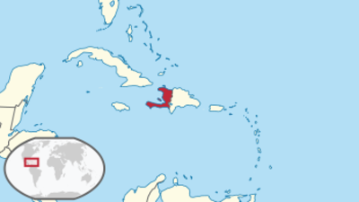
Haiti Location in World Map
Location Information of Haiti
Haiti is a Caribbean nation located on the island of Hispaniola, which it shares with the Dominican Republic. Known for its vibrant culture, complex history, and beautiful landscapes, Haiti has faced various challenges throughout its modern history, including political instability and natural disasters. Despite these hardships, Haiti remains a country of significant historical and cultural importance in the Caribbean.
Latitude and Longitude
Haiti lies at approximately 18.9712° N latitude and 72.2852° W longitude. The country is situated in the Greater Antilles, the group of islands that also includes Cuba, Jamaica, and Puerto Rico. Haiti occupies the western third of the island of Hispaniola, while the Dominican Republic occupies the eastern two-thirds. Haiti’s position places it in the Caribbean region, offering it both coastal plains and mountainous regions, which create a varied geography.
Capital City and Major Cities
Port-au-Prince (Capital City)
The capital of Haiti is Port-au-Prince, located on the Gulf of Gonâve in the western part of the country. As the largest city in Haiti, Port-au-Prince is the center of the country’s political, cultural, and economic life. With a population of around 2.5 million people, it is the largest urban area in the nation. The city has a complex history and remains an important site for Haitian culture and art. Some of the key attractions and features of Port-au-Prince include:
- Iron Market (Marché en Fer): A famous historical market where local artisans sell crafts, clothing, and food. The market is one of the oldest in Haiti and has been a focal point of trade for over a century.
- National Museum of Haiti: This museum showcases Haiti’s rich history, from the pre-colonial era to modern times. Artifacts from the Haitian Revolution, including paintings and sculptures, can be found here.
- Place des Héros: A monument dedicated to the heroes of the Haitian Revolution, located in the center of the city.
Port-au-Prince, however, has faced numerous challenges, including poverty, infrastructure deficiencies, and the impact of the 2010 earthquake. Despite these issues, the city is a cultural hub, with a vibrant music and art scene.
Cap-Haïtien
Cap-Haïtien is Haiti’s second-largest city and is located on the northern coast of the island. It is a historical city with significant cultural and architectural landmarks, many of which date back to the colonial era. Some of the key features of Cap-Haïtien include:
- Citadelle Laferrière: A UNESCO World Heritage site and one of Haiti’s most iconic landmarks. Built in the 19th century, it was constructed to defend the country from foreign invaders after independence.
- Sans-Souci Palace: A former royal palace built by King Henry Christophe, located near the Citadelle Laferrière. The palace is an important symbol of Haiti’s early post-independence history.
- Labadee: A popular beach resort area in Cap-Haïtien, known for its beautiful beaches and clear waters, which attract tourists, especially cruise passengers.
Les Cayes
Les Cayes is a port town located in the southwestern part of Haiti, near the country’s coastline. It is known for its beautiful beaches and proximity to Île à Vache, an island known for its pristine natural beauty. The city serves as a commercial and agricultural center, primarily dealing with crops like rice, coffee, and sugarcane. It also serves as a gateway for tourists visiting the nearby islands and the southern region of Haiti.
Jacmel
Located on the southern coast, Jacmel is a historic city known for its colonial architecture and vibrant arts scene. The city is also a significant tourist destination due to its beautiful beaches, waterfalls, and historical sites. Jacmel is famous for its Carnival, an annual event that features traditional music, costumes, and dance. Notable attractions include:
- Bassin Bleu: A series of picturesque waterfalls and natural pools located in the mountains near Jacmel.
- Citadelle du Roi Christophe: A historic fortification that is part of Haiti’s national heritage.
Gonaïves
Gonaïves is a port city located on Haiti’s northern coast. It is an important agricultural hub, known for its production of rice and maize. Gonaïves is also historically significant as the site where Haiti declared its independence in 1804. The city hosts annual events celebrating Haiti’s independence, and its Place d’Armes is a popular gathering place for locals and tourists alike.
Time Zone
Haiti operates in Haitian Standard Time (HT), which is UTC -5 during standard time and UTC -4 during daylight saving time. Daylight saving time is observed from mid-April to mid-October.
Climate
Haiti has a tropical climate, which varies according to elevation and proximity to the coast. The coastal regions are generally hot and humid, while the inland areas, especially the mountains, experience cooler temperatures.
Wet Season (May to October)
The wet season is characterized by high humidity and frequent afternoon rain showers. Tropical storms and hurricanes can sometimes affect Haiti, especially in the months of August through October. The rain brings much-needed water to the country’s agriculture, but it can also cause flooding and mudslides, especially in the more mountainous regions.
Dry Season (November to April)
The dry season brings lower humidity and cooler temperatures, especially in the higher altitudes. This is generally the most pleasant time to visit, as the weather is less humid, and rain is less frequent. However, coastal areas can still experience higher temperatures.
The average temperature in Haiti ranges from 77°F (25°C) in the highlands to 88°F (31°C) in the coastal areas.
Economic Status
Haiti is one of the poorest countries in the Western Hemisphere, with a majority of the population living below the poverty line. The country has faced numerous challenges, including political instability, natural disasters (especially the devastating 2010 earthquake), and a lack of infrastructure. Despite these challenges, the economy of Haiti relies on several key sectors:
Agriculture
Agriculture plays a vital role in Haiti’s economy, with coffee, sugarcane, mangoes, bananas, and rice being some of the country’s main exports. However, the agricultural sector has been plagued by issues such as land degradation, outdated farming techniques, and vulnerability to natural disasters like hurricanes and droughts.
Manufacturing
Haiti’s manufacturing sector is relatively small, but it includes industries such as textiles (Haiti is a significant exporter of clothing, particularly to the United States), light manufacturing, and assembly industries. In recent years, the country has attracted some foreign investment in its garment industry, especially through preferential trade agreements like the Hemispheric Opportunity through Partnership Encouragement (HOPE) Act.
Remittances
A significant portion of Haiti’s income comes from remittances sent by the Haitian diaspora, particularly those living in the United States. It is estimated that remittances account for around 30% of the country’s GDP, making it one of the most remittance-dependent countries in the world.
Services and Tourism
Although tourism has been adversely affected by natural disasters and political instability, the sector is still an important contributor to Haiti’s economy. Tourist attractions such as Labadee, Jacmel, and Port-au-Prince offer opportunities for growth in ecotourism and cultural tourism, provided that infrastructure improves.
Tourist Attractions
Haiti is home to a variety of historical, cultural, and natural attractions. Despite the challenges it faces, the country has much to offer tourists:
Citadelle Laferrière
One of Haiti’s most famous landmarks, Citadelle Laferrière, is a symbol of Haitian independence and resistance. The citadel is located in the mountains near Cap-Haïtien and was built after the Haitian Revolution to defend the country from French forces. It offers stunning views and serves as a UNESCO World Heritage site.
Labadee
Labadee is a privately leased resort area located on Haiti’s northern coast, near Cap-Haïtien. It is a popular destination for cruise ships, offering pristine beaches, water sports, and cultural events. The area is known for its relaxed atmosphere and natural beauty.
Bassin Bleu Waterfalls
Located in the southern part of Haiti, the Bassin Bleu Waterfalls is a series of waterfalls nestled in a lush, tropical forest. The waterfalls are surrounded by scenic hiking trails and are a popular spot for locals and visitors to swim in the natural pools.
Jacmel
Known for its rich history and colonial architecture, Jacmel is an important cultural destination. The city is also famous for its annual Carnival celebrations, which feature vibrant parades, traditional music, and colorful costumes.
Iron Market
Located in Port-au-Prince, the Iron Market is a bustling marketplace that has been an integral part of Haitian life for over a century. It’s a great place to experience local culture and buy Haitian crafts, textiles, and other goods.
Visa Requirements for U.S. Citizens
U.S. citizens do not need a visa for short-term stays (up to 90 days) in Haiti for tourism or business purposes. However, a valid U.S. passport is required, and travelers should ensure that their passport is valid for at least six months from the date of entry.
If staying for more than 90 days or visiting for purposes other than tourism or business, U.S. citizens must apply for an appropriate visa through the Haitian Embassy or Consulate before traveling.
Distance to New York City and Los Angeles
- New York City to Port-au-Prince: The flight distance from John F. Kennedy International Airport (JFK) to Toussaint Louverture International Airport (PAP) in Port-au-Prince is approximately 1,100 miles (1,770 kilometers), with a flight time of about 3 hours.
- Los Angeles to Port-au-Prince: The distance from Los Angeles International Airport (LAX) to Port-au-Prince is approximately 3,000 miles (4,800 kilometers), with a flight time of around 5-6 hours.
Haiti Facts
| Size | 27,750 km² |
| Residents | 11.12 million |
| Languages | French, Creole |
| Capital | Port-au-Prince |
| Longest river | Artibonite (240 km in Haiti) |
| Highest mountain | Pic la Selle (2,674 m) |
| Currency | Gourde |


