Where is Central African Republic Located?
Where is Central African Republic located on the map? Central African Republic is an independent nation located in Central Africa. Check out the following images to see location of Central African Republic on maps.
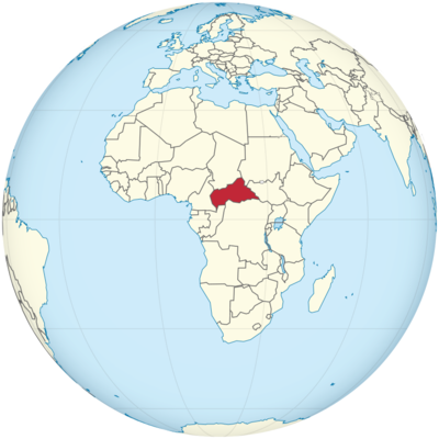
Central African Republic Location in World Map
The Central African Republic is located in the middle of Africa as you can see on the map.
Location Information of the Central African Republic
The Central African Republic (CAR) is a landlocked country located in the heart of Africa. Despite being geographically central, the country has experienced significant challenges in terms of political stability, infrastructure development, and economic growth. The Central African Republic is bordered by six countries: Cameroon to the west, Chad to the north, Sudan to the northeast, South Sudan to the east, the Democratic Republic of the Congo (DRC) and the Republic of the Congo to the south.
Latitude and Longitude
The Central African Republic is situated approximately between 4.4° N latitude and 18.6° E longitude. This central location in Africa places it equidistant from both the Atlantic Ocean to the west and the Indian Ocean to the east, though it remains landlocked, contributing to its economic isolation and dependence on neighboring countries for trade routes.
Capital City and Major Cities
Capital City: Bangui
The capital city of the Central African Republic is Bangui, located in the southwestern part of the country, near the Ubangi River. As the largest city in CAR, Bangui is the political, economic, and cultural hub of the nation. The city serves as the administrative and financial center, with most government institutions, foreign embassies, and international organizations based here. As of recent estimates, Bangui has a population of around 700,000 people, though this figure can fluctuate due to the country’s security situation.
Bangui has a relatively small urban footprint, but it is a central gathering place for commerce, trade, and diplomacy. The city is also known for its rich cultural life, including music, festivals, and traditional arts. However, Bangui has struggled with infrastructure and public services due to ongoing conflicts and instability in the region.
Major Cities
- Birao
Birao is a small town located in the northern part of the Central African Republic, in the Ouham-Fafa region. It is an important regional administrative center and a trade hub, though it is less developed than Bangui. Birao has a population of around 15,000 to 20,000 people, and like many parts of CAR, it has been affected by the instability and conflict in the region. - Kaga-Bandoro
Kaga-Bandoro is located in the northern part of CAR and serves as a major economic and transportation center in the region. It is situated on the Ouham River and has a population of approximately 30,000 people. Kaga-Bandoro has been an important point of trade for agricultural goods, including crops such as millet, maize, and cassava. - Berbérati
Situated in the southwestern part of the country, Berbérati is one of the larger towns in CAR. It has an estimated population of 50,000 to 60,000 people and serves as a regional administrative center for the Mambéré-Kadéï region. The town is known for its agricultural production, including rice, yams, and cassava. - Bouar
Bouar is located in the west-central part of the Central African Republic, close to the border with Cameroon. It is an important commercial and transport hub, with a population of approximately 30,000 people. The city serves as a strategic crossroads for trade and transportation routes, particularly those connecting the CAR to neighboring Cameroon.
Time Zone
The Central African Republic operates on West Africa Time (WAT), which is UTC+1. This means the country is one hour ahead of Coordinated Universal Time (UTC). It does not observe Daylight Saving Time (DST), so the time remains consistent year-round. The country shares the same time zone with several other West and Central African countries, such as Cameroon, Chad, and the Republic of the Congo.
Climate
The Central African Republic experiences a tropical climate, with distinct wet and dry seasons. The climate varies slightly depending on the region, but in general, it is characterized by high temperatures and relatively consistent rainfall throughout the year. The country is divided into two main climatic zones: the rainforest zone in the south and the savanna zone in the north.
Temperature
Average temperatures in the Central African Republic typically range from 24°C (75°F) to 32°C (90°F). The temperature remains fairly constant year-round, though there can be variations between the rainy and dry seasons. In the northern part of the country, the temperature tends to be higher, particularly during the dry season.
Rainfall
Rainfall is abundant in the Central African Republic, particularly in the southern and central regions. The rainy season usually lasts from May to October, with the heaviest rains occurring from June to September. During this time, precipitation can range from 1,200 mm to 2,000 mm (47 to 79 inches) annually, particularly in the rainforests. The northern regions of the country, in contrast, are drier, with a more pronounced dry season from November to April.
Dry Season
The dry season typically lasts from November to April, with the months of January to March being the driest. The harmattan winds from the Sahara Desert occasionally affect the climate in the northern part of the country, leading to dust and drier conditions.
Economic Status
The Central African Republic is one of the poorest countries in the world, with a GDP of approximately $2.3 billion USD. The economy is highly dependent on natural resources, particularly agriculture, mining, and forestry. However, due to ongoing civil conflict and a lack of infrastructure, much of the country’s economic potential remains untapped.
Key Industries
- Agriculture
Agriculture is the mainstay of the economy, employing a large portion of the population. The CAR produces a variety of crops, including cassava, maize, millet, sorghum, yams, and plantains. Livestock farming, particularly cattle, is also important. The agricultural sector, however, suffers from poor infrastructure and limited access to markets due to the country’s security challenges. - Mining
The Central African Republic is rich in natural resources, particularly diamonds, gold, and uranium. The country is considered a significant producer of diamonds, though much of the mining industry operates informally and is subject to smuggling. Gold and timber are other important exports, although the potential of the mining sector is hampered by instability and poor regulation. - Forestry
CAR is home to vast forest resources, which are used for timber production and other forest products. Despite the country’s abundance of forests, illegal logging and overexploitation of timber have posed sustainability challenges for the sector. - Oil and Gas
Although not a major player in the oil industry, the Central African Republic has some reserves of oil and gas, which remain largely unexplored. Oil production is limited and does not contribute significantly to the national economy. - Services and Trade
The service sector in CAR is underdeveloped, although retail, telecommunications, and financial services have grown in recent years. International trade is limited, primarily due to security issues and limited infrastructure, making CAR reliant on its neighbors for trade routes.
Tourist Attractions
While the Central African Republic is not widely known as a tourist destination, it does offer some unique attractions for visitors interested in ecotourism, wildlife, and adventure travel. However, due to the political instability and security risks, the country is not considered a mainstream tourist destination.
Wildlife and National Parks
- Dzongu National Park
Dzongu National Park, located in the southwestern region of the country, is known for its rich biodiversity, including various species of primates, elephants, and antelopes. The park offers a rare opportunity for wildlife enthusiasts to see animals in their natural habitats. - Manovo-Gounda St. Floris National Park
This UNESCO World Heritage Site is located in the northeastern part of CAR. The park is home to a variety of wildlife, including elephants, lions, giraffes, and buffalo. It is one of the most biodiverse parks in Africa but has suffered from poaching and the instability in the region. - Chinko Nature Reserve
The Chinko Nature Reserve is an area of pristine wilderness located in the eastern part of CAR. It is an important sanctuary for various species of wildlife, including African elephants and big cats like leopards and lions. The reserve offers opportunities for safaris and wildlife viewing.
Cultural Sites
The Central African Republic has a rich history and cultural heritage, though many of its historical and cultural sites are difficult to access due to security concerns. Some notable cultural destinations include:
- Bangui
The capital city itself has several cultural landmarks, including the National Museum of the Central African Republic, which displays traditional art and historical artifacts. The city also has a vibrant music scene and hosts various cultural festivals throughout the year. - Traditional Villages
Visitors to CAR can experience traditional village life by visiting rural areas, where they can see the art, crafts, and daily practices of local communities. Many villages maintain their traditional ways of life and are known for their colorful textiles, masks, and music.
Visa Requirements for U.S. Citizens
U.S. citizens are required to obtain a visa to visit the Central African Republic. Visas can be obtained from the Central African Republic Embassy or Consulate in the United States or from the embassy in a neighboring country. The visa process generally requires the submission of a valid passport, application form, passport-sized photos, and proof of travel arrangements.
Due to the security situation in CAR, U.S. travelers are advised to check the latest U.S. Department of State travel advisories before planning a trip. Yellow fever vaccination is mandatory for entry into the country, and travelers should also ensure they have health insurance and access to emergency evacuation services, as medical facilities in the country are limited.
Distance to Major U.S. Cities
- Distance to New York City
The distance from New York City (JFK Airport) to Bangui is approximately 7,300 miles (11,748 kilometers). A flight from New York to Bangui typically involves one or more layovers and can take around 15 to 20 hours, depending on the route and connection times. - Distance to Los Angeles
The distance from Los Angeles (LAX Airport) to Bangui is about 8,000 miles (12,875 kilometers). Flights from Los Angeles generally take about 17 to 21 hours, depending on layovers and flight routes.
Central African Republic Facts
| Size | 622,436 km² |
| Residents | 4.66 million |
| Languages | Sango, French |
| Capital | Bangui |
| Longest river | – |
| Highest mountain | Mont Ngaoui (1,420 m) |
| Currency | CFA franc |


