Where is Republic of the Congo Located?
Where is Republic of Congo located on the map? Republic of the Congo is an independent nation located in Central Africa. Check out the following images to see location of Republic of Congo on maps.
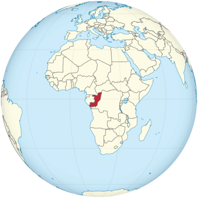
Republic of Congo Location in World Map
On the map you can see where the Republic of the Congo is located.
Location Information of the Republic of the Congo
Latitude and Longitude
The Republic of the Congo, often referred to as Congo-Brazzaville, is located in Central Africa. It shares borders with several countries: Cameroon to the north, Central African Republic to the northeast, Democratic Republic of the Congo (DRC) to the east and south, and Gabon to the west. The country also has a coastline along the Atlantic Ocean to the southwest. The geographic coordinates of the Republic of the Congo are approximately between Latitude 4° 30′ N and 13° 30′ N and Longitude 11° 00′ E and 18° 30′ E.
The Congo River, one of the largest rivers in Africa, forms much of the country’s border with the DRC and flows through its southern region. The country’s location places it in the heart of Africa, providing it with diverse ecosystems and an abundance of natural resources.
Capital City and Major Cities
Capital City: Brazzaville
Brazzaville is the capital and largest city of the Republic of the Congo, located on the western bank of the Congo River, directly across from Kinshasa, the capital of the Democratic Republic of the Congo. Brazzaville has a population of approximately 1.8 million people and is the political, cultural, and economic center of the country. As one of the oldest cities in Central Africa, Brazzaville has historical significance dating back to the French colonial era.
Key landmarks in Brazzaville include the Palais du Peuple, Basilique Sainte-Anne, and The National Museum of the Republic of the Congo. The city is also home to the Brazzaville Grand Market, where visitors can buy local crafts, fabrics, and produce. Brazzaville is known for its relatively stable political environment and its role as a regional hub for trade, business, and diplomacy.
Major Cities
- Pointe-Noire
Pointe-Noire is the second-largest city in the Republic of the Congo, located on the Atlantic coast. It serves as the country’s main port and commercial center. With a population of about 1 million people, it is the economic hub of the country, especially in oil and gas production. Pointe-Noire is also home to the Pointe-Noire Port, which handles the majority of the Republic of the Congo’s exports, including oil, minerals, and timber. The city’s coastal location also makes it an important center for maritime trade and fishing. - Dolisie
Dolisie, formerly known as Loubomo, is located in the southern part of the country. It is an important regional center for trade and agriculture, particularly for the production of cocoa, coffee, and palm oil. Dolisie has a smaller population compared to Brazzaville and Pointe-Noire but is an essential city for the national economy. The city is well-connected to other parts of the country through road networks and railways. - Oyo
Oyo is located in the north-central part of the Republic of the Congo. It is a smaller city but holds historical significance as the former capital of the country during the colonial period. Oyo is situated near the Nkoula-Nkunda river, a tributary of the Congo River. The town is primarily focused on agriculture, with crops like cassava and yams being important to the local economy. - Nkayi
Nkayi is located in the southwestern region of the Republic of the Congo and is known for its agricultural activities, particularly in the cultivation of maize, cassava, and tobacco. The city is also a regional administrative center, providing services to surrounding rural areas. - Kinkala
Kinkala, located in the southern part of the country, is a small city and the capital of the Pool Department. The city plays a central role in the local agricultural economy, particularly for crops like cassava, plantains, and corn. The city is important for its proximity to the capital, Brazzaville, and serves as an entry point into the Congo’s rural heartlands.
Time Zone
The Republic of the Congo operates in the West Africa Time Zone (WAT), which is UTC +1:00 hours. This time zone is used throughout the country and does not observe daylight saving time. This means that the time remains constant throughout the year, with no seasonal changes.
The time zone of the Republic of the Congo is shared with several other countries in Central and West Africa, including Cameroon, Gabon, Chad, and Nigeria. The consistency of time across these nations helps with regional coordination in trade, transport, and communications.
Climate
The climate of the Republic of the Congo is primarily tropical, with variations depending on the region. Due to the country’s location near the equator, the weather tends to be hot and humid year-round. The country experiences distinct wet and dry seasons, which influence agriculture, infrastructure, and daily life.
Wet and Dry Seasons
The wet season in the Republic of the Congo typically lasts from October to May, with the heaviest rainfall occurring between March and May. During this time, the country experiences frequent thunderstorms, and the rivers swell due to heavy rains, leading to potential flooding in low-lying areas. The average rainfall can reach 1,500 mm (59 inches) annually, with coastal areas experiencing higher amounts of precipitation compared to inland areas.
The dry season, which lasts from June to September, is characterized by reduced rainfall and hotter, drier conditions. Average temperatures during the dry season range from 28°C (82°F) to 35°C (95°F), while the wet season sees temperatures between 24°C (75°F) and 30°C (86°F). The humidity levels are high throughout the year, especially in the coastal regions, making the climate feel warmer than the actual air temperature.
Regional Climate Variations
- Coastal Areas (Pointe-Noire): These regions are subject to humid conditions with high rainfall during the wet season, but temperatures remain moderate due to the cooling effect of the Atlantic Ocean. The average temperature along the coast is around 27°C (81°F) year-round.
- Central and Northern Regions: These areas, particularly around Brazzaville and the Congo River, experience a more pronounced wet season, with high humidity and frequent rainstorms, especially from March to May.
- Southern Regions (Oyo and Dolisie): The southern part of the country experiences more distinct seasonal changes, with a hot dry period from June to August, followed by intense rainfall. The central highlands are slightly cooler than the coastal regions due to their elevation.
Economic Status
The Republic of the Congo has a developing economy largely based on its abundant natural resources. The country’s major exports include oil, timber, minerals, and agricultural products. The economy has grown significantly in recent years, mainly driven by the oil industry, although it still faces challenges such as income inequality, high unemployment, and reliance on natural resource exports.
Key Economic Sectors
- Oil and Gas
Oil is the main driver of the Republic of the Congo’s economy, contributing to over 60% of the country’s GDP. The country is a major producer of crude oil, primarily extracted offshore in the Congo Basin. Oil and gas exports provide the majority of government revenue, though fluctuations in oil prices have had significant impacts on the country’s economic stability. - Mining
Mining is another crucial industry in the Republic of the Congo. The country is rich in minerals, including gold, copper, iron ore, and diamonds. Manganese is one of the most valuable minerals produced in the country. The mining industry has attracted foreign investment and has the potential to become an even more significant economic driver. - Agriculture
Agriculture remains an important sector for the Republic of the Congo’s rural population. Key crops include cassava, corn, plantains, palm oil, and cocoa. The country has vast tracts of arable land, but agricultural production is limited by poor infrastructure and a lack of modern agricultural technology. - Timber and Forest Products
The Republic of the Congo has large tracts of tropical rainforests that are rich in valuable timber, including mahogany, ebony, and okoumé. Logging and the export of timber have been key sources of income for the country. However, sustainable forest management remains a challenge, and illegal logging is an ongoing concern. - Services
The services sector is growing, particularly in finance, telecommunications, and transportation. Major international companies have established offices in Brazzaville and Pointe-Noire, and tourism has also become a growing sector in the country’s economy. The government has made efforts to diversify the economy by promoting tourism, technology, and finance, but the overall economic structure remains highly dependent on oil.
Tourist Attractions
The Republic of the Congo is a country rich in natural beauty, wildlife, and cultural heritage. The country offers a range of tourism opportunities, from wildlife safaris and rainforest exploration to visiting historical landmarks.
- Odzala-Kokoua National Park
Located in the northern part of the country, this park is one of Africa’s most biodiverse rainforests and a UNESCO World Heritage Site. It is home to a variety of wildlife, including gorillas, elephants, chimpanzees, and buffalo. The park is a popular destination for eco-tourism and wildlife enthusiasts. - Nouabalé-Ndoki National Park
Nouabalé-Ndoki is another pristine rainforest park in the Congo Basin. It is home to one of the largest populations of Western lowland gorillas and offers an incredible opportunity to see these endangered species in the wild. The park is part of the Sangha Tri-National region, shared with Cameroon and the Central African Republic. - Pointe-Noire
The city of Pointe-Noire is known for its coastal beauty and vibrant culture. Visitors can explore the Pointe-Noire National Museum, enjoy the beaches, and take boat trips along the Atlantic coast. Pointe-Noire also has historical significance, with landmarks like the Saint-Louis Cathedral. - Brazzaville
Brazzaville offers a range of cultural and historical attractions, including Pointe Indienne on the Congo River, the National Museum, and Basilique Sainte-Anne. The city is also home to beautiful parks and markets that reflect the vibrant culture of the Congo. - La réserve de la Lefini
This nature reserve, located southeast of Brazzaville, is a popular site for wildlife enthusiasts. It is known for its biodiversity and is home to a variety of species, including the Congo buffalo and African elephants.
Visa Requirements for U.S. Citizens
U.S. citizens traveling to the Republic of the Congo for tourism purposes are required to obtain a visa. The visa application process typically involves submitting an application form, passport photographs, and proof of sufficient funds. Visitors must also show a valid passport, which should be valid for at least six months beyond the date of arrival. U.S. citizens may also need to provide proof of return or onward travel.
Visas can be obtained from the Embassy of the Republic of the Congo in Washington, D.C., or other consular offices abroad.
Distance to New York City and Los Angeles
- Distance from New York City to Brazzaville
The distance from New York City to Brazzaville is approximately 6,800 miles (10,944 kilometers). Flights typically take around 14 to 16 hours, depending on the number of layovers. - Distance from Los Angeles to Brazzaville
The distance from Los Angeles to Brazzaville is about 8,000 miles (12,875 kilometers). Flights generally take between 16 and 18 hours, depending on the flight path and layovers.
Republic of Congo Facts
| Size | 342,000 km² |
| Residents | 5.24 million |
| Language | French |
| Capital | Brazzaville |
| Longest river | Kouilou (700 km) |
| Highest mountain | Mount Nabemba (1,020 m) |
| Currency | CFA franc |


