Where is Cambodia Located?
Where is Cambodia located on the map? Cambodia is an independent nation located in Southeastern Asia. Check out the following images to see location of Cambodia on maps.
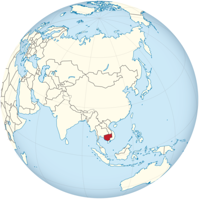
Cambodia Location in World Map
On the map you can see the location of Cambodia well.
Location Information of Cambodia
Latitude and Longitude
Cambodia is a country located in Southeast Asia, bordered by Thailand to the northwest, Laos to the north, Vietnam to the east and south, and the Gulf of Thailand to the southwest. The country’s geographical coordinates are:
- Latitude: 12.5655° N
- Longitude: 104.9915° E
The country lies in the Indochina Peninsula and features diverse topography, including coastal plains, mountainous regions, and vast river systems such as the Mekong River. The presence of the Mekong River and the Tonle Sap Lake makes Cambodia’s geography ideal for agriculture, especially rice cultivation.
Capital City and Major Cities
- Capital City: Phnom PenhThe capital and largest city of Cambodia is Phnom Penh, located in the southwestern part of the country, at the confluence of the Mekong, Tonle Sap, and Bassac rivers. Phnom Penh serves as the political, cultural, and economic hub of Cambodia, with a population of approximately 2 million people. It is a dynamic city that reflects both the traditional Khmer culture and the influences of French colonial architecture.
- Key Features: Phnom Penh is home to important landmarks such as the Royal Palace, Silver Pagoda, Independence Monument, and National Museum. The city has an emerging modern skyline, and its street life is bustling, with markets, restaurants, and businesses located throughout.
- Major Cities:
- Siem Reap: Siem Reap, located in the northwestern part of Cambodia, is one of the most popular tourist destinations, primarily due to its proximity to the ancient Angkor Wat complex. The city has a population of about 200,000 and is a major center for tourism and culture. It is also known for its lively markets, hotels, and vibrant nightlife.
- Sihanoukville: Located on the southwestern coast, Sihanoukville is Cambodia’s primary port city and a hub for tourism, especially with its growing beach resorts along the Gulf of Thailand. The city is known for its stunning beaches, including Otres Beach and Victory Beach, and is rapidly becoming a hotspot for international travelers.
- Battambang: Situated in the northwest, Battambang is a provincial capital with a population of approximately 150,000 people. The city is known for its historical French colonial architecture and its role as an agricultural center, particularly for rice cultivation. Battambang is also home to cultural landmarks like the Bamboo Train and several ancient temples.
- Kampong Cham: Located along the Mekong River, Kampong Cham is one of Cambodia’s oldest cities and is known for its scenic views and proximity to ancient ruins, including Wat Nokor and the Nokor Bachey Temple. The city also serves as an important agricultural center for crops like rubber and cassava.
- Kep: A small coastal town, Kep is known for its colonial architecture, seafood, and the nearby Kep National Park. The town is also famous for its crab market, where fresh seafood, particularly blue crabs, is sold.
Time Zone
Cambodia is in the Indochina Time Zone (ICT), which is UTC +7. The country does not observe Daylight Saving Time, so the time zone remains consistent throughout the year. This time zone is shared with neighboring countries such as Vietnam, Thailand, and Laos.
Climate
Cambodia has a tropical climate, characterized by distinct wet and dry seasons. Due to its proximity to the equator, Cambodia experiences high temperatures and humidity year-round, although there are some variations based on altitude and proximity to bodies of water like the Tonle Sap Lake and the Mekong River.
- Wet Season (May to October): Cambodia experiences its wet season from May to October, driven by the monsoon winds from the Indian Ocean. This period sees heavy rainfall, particularly in the southern and central parts of the country. Temperatures remain high, generally ranging from 25°C (77°F) to 35°C (95°F), but the heavy rains help cool down the atmosphere. The wet season is crucial for agriculture, particularly rice cultivation.
- Dry Season (November to April): The dry season lasts from November to April, with December to February being the most pleasant months, featuring cooler temperatures and lower humidity. During this period, the average temperature ranges from 25°C (77°F) to 30°C (86°F), though it can rise significantly in the hot months of March and April. The dry season is the best time to visit Cambodia, especially for outdoor activities and temple visits.
- Regional Variations: While the climate is generally tropical, the highland regions of Cambodia tend to be cooler, with temperatures dropping significantly at night. Sihanoukville and other coastal areas experience more moderate temperatures, while the lowlands in the central and northern parts can become very hot, especially in the dry season.
Economic Status
Cambodia’s economy is a mixed economy with a reliance on agriculture, textiles, tourism, and foreign investment. The country has experienced rapid economic growth over the past two decades, although it remains one of the poorest countries in Southeast Asia.
- Agriculture: Agriculture remains the backbone of Cambodia’s economy, with over 30% of the population dependent on it. The country is known for its rice production, and it is one of the top exporters of rice in the region. Other important agricultural products include cassava, rubber, corn, peanuts, and vegetables. The Mekong River and the Tonle Sap Lake provide fertile soil for rice cultivation.
- Textiles and Garments: The garment industry is Cambodia’s largest export sector, contributing significantly to the country’s GDP. Cambodia is a major supplier of textiles to the international market, especially for brands based in the U.S., European Union, and Asia. The industry provides millions of jobs, mostly for women, and remains a vital source of foreign exchange.
- Tourism: Cambodia has become an increasingly popular tourist destination, driven by iconic sites such as Angkor Wat, Siem Reap, and the beautiful beaches in the southwest. Tourism plays a significant role in Cambodia’s economy, contributing billions of dollars annually. The government has focused on promoting cultural tourism, eco-tourism, and coastal tourism to attract international visitors.
- Foreign Investment: Cambodia has attracted foreign investment in various sectors, including real estate, manufacturing, and infrastructure development. The government has worked to create a more favorable investment climate through tax incentives, favorable trade agreements, and industrial zones.
- Challenges: Despite its economic growth, Cambodia faces significant challenges, including income inequality, corruption, and human rights concerns. The country remains highly dependent on agriculture, and the textile sector is vulnerable to global market fluctuations. Additionally, Cambodia struggles with inadequate infrastructure, political instability, and environmental degradation.
Tourist Attractions
Cambodia is known for its rich cultural heritage, ancient temples, natural beauty, and thriving wildlife. Some of the country’s most significant tourist attractions include:
- Angkor Wat: The world-renowned Angkor Wat temple complex in Siem Reap is Cambodia’s most famous landmark and one of the largest religious monuments in the world. Built in the 12th century by the Khmer Empire, it is an iconic symbol of Cambodia and is listed as a UNESCO World Heritage site. Visitors come to explore the grandeur of the temple, the intricate carvings, and the surrounding ancient city of Angkor.
- Tonle Sap Lake: The Tonle Sap Lake, one of Southeast Asia’s largest freshwater lakes, is a fascinating natural wonder. It is vital to Cambodia’s ecosystem, supporting thousands of people who live in floating villages on its waters. Tourists can take boat tours of the lake to explore the local communities, birdlife, and fishing activities.
- Royal Palace and Silver Pagoda: Located in Phnom Penh, the Royal Palace is the residence of the King of Cambodia. The nearby Silver Pagoda, named for its silver-tiled floor, is home to a collection of precious artifacts, including the Emerald Buddha.
- Killing Fields and Tuol Sleng Genocide Museum: Cambodia’s tragic history under the Khmer Rouge regime (1975–1979) is commemorated at the Killing Fields near Phnom Penh and the Tuol Sleng Genocide Museum. These sites provide visitors with a sobering look at the atrocities committed during this dark period in Cambodia’s history.
- Sihanoukville and the Islands: Sihanoukville is the gateway to Cambodia’s beautiful coastal resorts, including Otres Beach and Koh Rong island. The coastal areas offer pristine beaches, clear waters, and opportunities for water sports like snorkeling, diving, and kayaking.
- Bokor National Park: Situated in the Cardamom Mountains, Bokor National Park is a popular destination for eco-tourists. The park is known for its misty mountains, cool climate, and biodiversity. Visitors can hike through the park, explore waterfalls, and visit the abandoned Bokor Hill Station, a former French colonial resort.
- Phnom Kulen National Park: Phnom Kulen is a sacred mountain with significant cultural and historical importance. The park is home to the River of a Thousand Lingas (a riverbed with carvings of Hindu deities), waterfalls, and ancient temples, making it a popular destination for those interested in nature and culture.
Visa Requirements for U.S. Citizens
U.S. citizens who wish to travel to Cambodia must obtain a visa before entering the country. The visa can be obtained through various methods:
- E-Visa: U.S. citizens can apply for an e-visa online, which is valid for 30 days. This process is quick, with an online form and payment for processing fees.
- Tourist Visa: A tourist visa can also be obtained on arrival at Phnom Penh and Siem Reap international airports, as well as at land border crossings. This visa is typically valid for 30 days and can be extended.
- Visa on Arrival: Cambodia offers a visa-on-arrival for U.S. citizens traveling for tourism purposes. The visa requires a valid passport, passport-sized photos, and a visa fee.
- Visa Requirements: The required documents include a passport that is valid for at least six months from the date of entry, a passport-sized photograph, and payment for the visa fee. Visitors may also need to show proof of onward travel or accommodation.
Distance to Major U.S. Cities
- Distance to New York City: The distance between Phnom Penh and New York City is approximately 8,500 miles (13,680 kilometers). The flight duration is typically 18–20 hours, depending on layovers in cities like Hong Kong, Dubai, or Doha.
- Distance to Los Angeles: The distance between Phnom Penh and Los Angeles is approximately 8,000 miles (12,875 kilometers). Flights from Phnom Penh to Los Angeles typically take 17–19 hours, with layovers in hubs like Taipei, Bangkok, or Hong Kong.
Cambodia Facts
| Size | 181,040 km² |
| Residents | 16.5 million |
| Language | Khmer |
| Capital | Phnom Penh |
| Longest river | Mekong (500 km in Cambodia) |
| Highest mountain | Phnom Aural (1,813 m) |
| Currency | Riel |


