Where is Andorra Located?
Where is Andorra located on the map? Andorra is an independent nation located in Southern Europe. Check out the following images to see location of Andorra on maps.
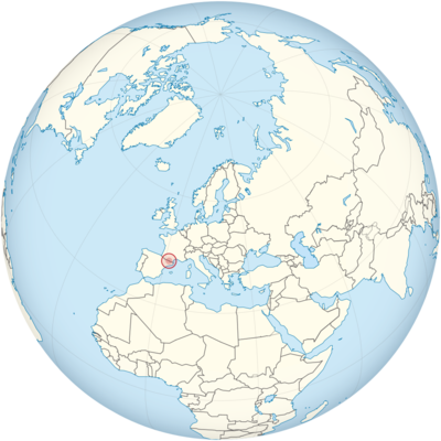
Andorra Location in World Map
Where is Andorra located? Andorra is very small – do you see the red dot? Click on the map!
Location Information of Andorra
Latitude and Longitude
Andorra is a small, landlocked country located in the Pyrenees mountains, bordered by France to the north and Spain to the south. This unique location places Andorra in Southwestern Europe, with its geographical coordinates approximately as follows:
- Latitude: 42.5078° N
- Longitude: 1.5211° E
Despite its small size, Andorra’s position in the Pyrenees gives it a strategic location between two major European countries, making it a popular travel destination for both French and Spanish tourists, especially for skiing and nature-based activities.
Capital City and Major Cities
- Capital City: Andorra la VellaAndorra la Vella is the capital and largest city of Andorra. Located at an elevation of 1,023 meters (3,356 feet) above sea level, it is the highest capital city in Europe. The city is a key center for the country’s economy, tourism, and government. Situated on the banks of the Valira River, Andorra la Vella is known for its picturesque views of the surrounding mountains and its blend of modern and traditional architecture. The city is also famous for its duty-free shopping, which draws many visitors from neighboring countries.
- Major Cities:
- Escaldes-Engordany – Located near Andorra la Vella, Escaldes-Engordany is the second-largest parish and known for its thermal spas. It is a popular area for tourists, with various wellness centers, and is also an economic hub due to its proximity to the capital.
- Encamp – Situated in the eastern part of the country, Encamp is another key town in Andorra. It is famous for its ski resorts, including the Grandvalira ski area, which is one of the largest ski resorts in Europe.
- Sant Julià de Lòria – Located in the southern part of the country, Sant Julià de Lòria is an important town known for its cultural sites and historical architecture. It is also a key gateway for tourists heading to the nearby ski resorts.
- La Massana – A small yet significant town in Andorra, La Massana is known for its beautiful landscapes and proximity to the Vallnord ski resort, attracting ski enthusiasts and nature lovers alike.
- Ordino – Ordino is located in the northern part of Andorra and is one of the most tranquil parishes, known for its rural beauty and outdoor activities like hiking, as well as its preserved traditional Andorran culture.
Time Zone
Andorra operates on Central European Time (CET), which is UTC+1 during the standard time. Like many European countries, Andorra observes Central European Summer Time (CEST), which is UTC+2, during the summer months from March to October. This daylight saving time helps to maximize daylight hours during the longer days of the year, contributing to a lively outdoor lifestyle in the warmer months.
Climate
Andorra’s climate varies depending on the altitude and geographic location, with its mountainous terrain playing a major role in shaping the country’s weather patterns. The country can be divided into three major climatic zones:
- Mountain Climate: The higher elevations in the Pyrenees experience a typical mountain climate, which is characterized by cold winters and mild summers. Snowfall is common in winter, making Andorra an attractive destination for winter sports like skiing and snowboarding. The highest points of the country, such as those near the ski resorts, have temperatures that can reach as low as -10°C (14°F) during winter.
- Temperate Climate: The valleys, where most of the population resides, experience a temperate climate, with warmer summers and cooler winters. The temperatures in the valleys can reach up to 25°C (77°F) in the summer months and drop to around 5°C (41°F) in the winter months.
- Continental Climate: In the lower-altitude areas, particularly those closer to Spain, the climate tends to be more continental, with hot summers and colder winters. This area experiences a significant amount of sunshine year-round, especially in the spring and summer months.
Rainfall is generally more frequent in the spring and fall months, while winters are marked by clear skies and dry conditions, making the country a popular winter destination for tourists. The combination of its diverse climate zones and mountainous terrain offers opportunities for a wide range of outdoor activities year-round.
Economic Status
Andorra has a unique economy characterized by low taxes, a high standard of living, and a strong focus on tourism, retail, and financial services. The country benefits from its location between France and Spain, which allows it to serve as a business and tourism hub for people from both countries and beyond.
- Tourism: Tourism is the backbone of Andorra’s economy, contributing a significant portion to its GDP. The country is especially popular for its ski resorts, which are among the largest in Europe, such as Grandvalira and Vallnord. Andorra attracts millions of tourists every year, drawn to its mountains for skiing, hiking, and mountaineering. The country also benefits from duty-free shopping, which encourages visitors from neighboring countries to come for retail therapy.
- Financial Services: Andorra has established itself as a center for banking and finance. The country offers favorable tax rates and banking secrecy laws, which have attracted businesses and individuals seeking to benefit from these incentives. As a result, Andorra’s financial sector is well-developed, contributing significantly to its economy.
- Retail and Commerce: Retail also plays an important role in the country’s economy. Due to its status as a duty-free zone, Andorra is a popular shopping destination for people from both France and Spain. Goods such as electronics, perfumes, and alcohol are sold at prices lower than in neighboring countries, making the country an attractive destination for shoppers.
- Agriculture: While the agricultural sector is not as dominant as tourism and finance, Andorra produces some agricultural goods, particularly in the fertile areas of the valleys. The country grows vegetables, fruits, and herbs, although the high altitudes limit large-scale agricultural production.
- Challenges and Opportunities: While Andorra enjoys a high GDP per capita and a strong economy, the country faces challenges related to its small size and lack of natural resources. There is also pressure to diversify its economy, particularly as the world moves toward more transparent banking systems. The country has worked to improve its image by signing agreements with the European Union to adopt international standards on money laundering and tax evasion.
Tourist Attractions
Andorra is a small country but packed with numerous attractions, particularly for nature lovers, sports enthusiasts, and those seeking a unique cultural experience. Some of the most notable tourist destinations in Andorra include:
- Grandvalira: As one of the largest ski resorts in Europe, Grandvalira is a top destination for winter sports. The resort offers a wide range of ski slopes, snowboarding opportunities, and après-ski activities. It attracts visitors from all over Europe and is a highlight of Andorra’s winter tourism industry.
- Vallnord: Another prominent ski resort, Vallnord is known for its high-quality ski facilities, with slopes that cater to both beginners and experienced skiers. The resort also offers mountain biking and hiking trails during the summer months, making it a year-round destination.
- Caldea: One of the largest spa complexes in Europe, Caldea is a thermal spa located in Escaldes-Engordany. The spa offers a range of wellness treatments, including hot springs, massage therapies, and health-focused facilities. It is particularly popular for relaxation and rejuvenation after a day of skiing or hiking.
- Andorra la Vella: The capital city itself is home to several attractions, including the historic Old Quarter, the Andorra National Museum, and the stunning Casa de la Vall, a historic building that was once the seat of the Andorran parliament. The city’s shopping district is a major draw, with a wide range of duty-free shops offering goods from luxury brands.
- Sant Joan de Caselles Church: Located in the parish of Canillo, this Romanesque church is one of Andorra’s most important architectural landmarks. It dates back to the 11th century and is known for its beautiful frescoes and peaceful setting.
- Engolasters Lake: Situated in the parish of Escaldes-Engordany, this stunning lake offers scenic hiking trails and opportunities for wildlife viewing. The area is perfect for outdoor activities like picnicking, hiking, and photography, and it provides breathtaking views of the surrounding mountains.
- Ordino Arcalís: A ski resort and a top destination for outdoor enthusiasts, Ordino Arcalís offers a range of activities beyond skiing, including mountaineering and hiking during the summer. The area is known for its natural beauty and rugged terrain.
Visa Requirements for U.S. Citizens
U.S. citizens do not require a visa to enter Andorra for short stays of up to 90 days within a 180-day period. Andorra is not a member of the European Union or the Schengen Area, but it has open borders with both Spain and France, both of which are part of the Schengen Area. This means that travelers to Andorra can enter the country through either of these countries without needing a separate visa for Andorra.
- Passport Requirements: U.S. citizens must have a valid U.S. passport with at least three months’ validity remaining beyond their planned date of departure from Andorra.
- Purpose of Visit: The 90-day visa exemption applies to tourism, business, and family visits. For longer stays, or for activities like working or studying, U.S. citizens will need to apply for an appropriate visa through Spain or France before entering Andorra.
- Travel Insurance: It is recommended for U.S. citizens to have comprehensive travel insurance, including health coverage, during their stay in Andorra.
Distance to Major U.S. Cities
Andorra is located relatively close to major European airports, but air travel to Andorra requires flying to neighboring Spain or France and then traveling overland to Andorra. The approximate distances from Andorra to major U.S. cities are:
- Distance to New York City: The distance from Andorra to New York City is approximately 5,750 miles (9,250 kilometers). Flights typically require a layover, often in Paris, Madrid, or Barcelona, and the travel time is typically around 10-12 hours.
- Distance to Los Angeles: The distance from Andorra to Los Angeles is around 6,200 miles (9,977 kilometers). Like New York, flights generally involve layovers and take about 12 to 14 hours of total travel time.
Andorra Facts
| Size | 468 km² |
| Residents | 77,000 |
| Language | Catalan |
| Capital | Andorra la Vella |
| Longest river | Valira (44 km) |
| Highest mountain | Coma Pedrosa (2942 m) |
| Currency | Euro |


