Where is Belarus Located?
Where is Belarus located on the map? Belarus is an independent nation located in Eastern Europe. Check out the following images to see location of Belarus on maps.
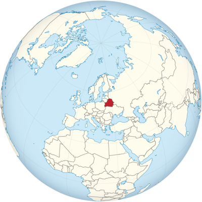
Belarus Location in World Map
Belarus is located in the east of Europe.
Location Information of Belarus
Latitude and Longitude
Belarus is located in Eastern Europe, bordered by Russia to the northeast, Ukraine to the south, Poland to the west, and Lithuania and Latvia to the northwest. It is a landlocked country, situated between major European regions and serving as a key transit point. The geographical coordinates of Belarus are:
- Latitude: 53.7098° N
- Longitude: 27.9534° E
These coordinates place Belarus in a region of Central and Eastern Europe, and it is positioned near the border of both the European Union and the Russian Federation. Its location has made it a historically strategic country, often influenced by its surrounding neighbors, particularly Russia and Poland.
Capital City and Major Cities
- Capital City: MinskMinsk is the capital and largest city of Belarus, located in the central part of the country. It is the political, cultural, and economic hub of Belarus, with a population of over 2 million people. Minsk is known for its Soviet-era architecture, wide boulevards, parks, and public squares. Key landmarks in the city include the Victory Square, the National Library of Belarus, and the Independence Avenue. Minsk also has a vibrant cultural scene with theaters, museums, and music venues. The city serves as the center of government, commerce, and industry in Belarus.
- Major Cities:
- Gomel – Located in the southeastern part of Belarus, Gomel is the second-largest city in the country. It is an important industrial and cultural center, known for its historical architecture, such as the Gomel Palace and the Palace and Park Ensemble. Gomel also has a well-developed transport infrastructure and is an important city for trade and commerce.
- Brest – Situated in the western part of Belarus, near the border with Poland, Brest is known for its historical significance, particularly the Brest Fortress, which played a key role during World War II. Brest is also an important transportation hub and has a strong industrial base.
- Vitebsk – Located in the northeast of the country, Vitebsk is known for its cultural heritage, including the Vitebsk Art School and the annual Slavianski Bazaar music festival. The city is also home to the Marc Chagall Museum, dedicated to the famous artist who was born in Vitebsk.
- Mogilev – Situated in the eastern part of Belarus, Mogilev is an important industrial and cultural city. It has a rich history, with landmarks such as the Mogilev Regional Museum of Art and the Saint Nicholas Church. The city is also known for its textiles, machinery, and food processing industries.
- Hrodna (Grodno) – Located near the borders with Poland and Lithuania, Hrodna is one of the oldest cities in Belarus. It has a rich historical and architectural heritage, including the Hrodna Castle and the Kalozha Church of Sts. Boris and Gleb. The city is also known for its universities and research institutes.
Time Zone
Belarus operates on Minsk Time, which is UTC +3 year-round. The country does not observe daylight saving time, meaning that the time remains the same throughout the year. Belarus shares its time zone with other countries in the region, including Russia and parts of the Middle East.
Climate
Belarus has a temperate continental climate, with cold winters and warm summers. Due to its location in the heart of Europe and its landlocked position, Belarus experiences significant temperature variations throughout the year, influenced by its geographical features, such as forests, rivers, and lakes.
- Winter: Winters in Belarus are cold, with temperatures often dropping below freezing. December, January, and February are the coldest months, with average temperatures ranging from -6°C (21°F) to -12°C (10°F). Snowfall is common during this time, and the country often experiences long periods of snow cover. The harsh winter weather can cause transportation disruptions and pose challenges for infrastructure.
- Summer: Summers in Belarus are generally mild to warm, with temperatures ranging from 18°C (64°F) to 25°C (77°F). July is the warmest month, with average temperatures reaching around 20°C (68°F). Summer brings longer days and more sunlight, making it a popular time for outdoor activities, festivals, and cultural events.
- Rainfall: Belarus receives moderate rainfall throughout the year, with the wettest months occurring in the late spring and summer (May through August). Rain is typically distributed evenly throughout the year, though autumn can be a particularly rainy season. The average annual precipitation is about 600 to 700 mm (24 to 28 inches), contributing to the country’s lush forests and fertile soil.
- Spring and Autumn: Spring and autumn in Belarus are transitional seasons, with fluctuating temperatures and conditions. Spring is marked by rising temperatures and the melting of snow, while autumn sees a gradual cooling of the climate. Both seasons are relatively short, but they bring beautiful natural displays, such as the blooming of wildflowers in spring and the colorful foliage in autumn.
Economic Status
Belarus has a mixed economy with a significant state-controlled sector, particularly in areas like energy, agriculture, and manufacturing. The country’s economic development is shaped by its historical ties to Russia, its dependence on heavy industries, and its relatively recent transition from a Soviet-style economy. Belarus has faced challenges such as limited foreign investment, a reliance on state-owned enterprises, and political restrictions, yet it has managed to maintain steady economic growth in recent years.
- Manufacturing and Industry: Belarus has a strong industrial base, with key sectors including machinery, chemicals, and food processing. The country is known for its production of heavy machinery, agricultural equipment, and transport vehicles, such as tractors made by Belarus Tractors. The chemical industry, including the production of fertilizers, petrochemicals, and synthetic materials, is also significant. Minsk is home to several large state-owned factories and enterprises in these sectors.
- Agriculture: Agriculture plays a major role in the Belarusian economy, with the country producing significant amounts of cereals, potatoes, vegetables, and livestock. Belarus is one of the leading global producers of potash, a key ingredient in fertilizer production, which accounts for a large portion of its agricultural exports. The country is also a major exporter of dairy products, meat, and poultry. The agricultural sector faces challenges due to aging infrastructure and the need for modernization.
- Energy: Belarus is heavily reliant on energy imports, particularly from Russia, and has faced challenges in managing energy resources. The energy sector is dominated by state-owned companies that manage oil refining, electricity generation, and natural gas distribution. Belarus is working on diversifying its energy sources, particularly by exploring renewable energy and seeking greater energy efficiency.
- Services Sector: The services sector in Belarus is growing, particularly in the areas of banking, information technology, and telecommunications. Minsk is home to several international banks, and the country has seen growth in its information technology sector, particularly with the establishment of a High-Tech Park in Minsk. However, the services sector remains smaller compared to manufacturing and agriculture.
- Trade and Foreign Investment: Belarus relies heavily on trade with Russia and the European Union, particularly for energy supplies and exports. It has benefited from trade agreements with Russia and other countries in the region, but foreign direct investment has been limited by its political system and economic policies. Belarus has made efforts to diversify its economy and attract foreign investment, but the government’s control over major industries has hindered the development of a more market-oriented economy.
- Challenges: Belarus faces several economic challenges, including a reliance on state-owned enterprises, limited access to international markets, and low levels of foreign direct investment. The country’s political environment and government control over key industries have hindered the development of a more open and competitive market economy. Additionally, Belarus is vulnerable to fluctuations in global commodity prices, particularly for energy and raw materials.
Tourist Attractions
Belarus is known for its picturesque landscapes, rich cultural heritage, and historic landmarks. While not as well-known as some other European destinations, the country offers a range of attractions for visitors, from medieval castles to pristine nature reserves. Some of the key tourist attractions in Belarus include:
- Minsk: The capital city is home to numerous cultural and historical landmarks, such as the Independence Square, the National Library of Belarus, and the Victory Square. Minsk also boasts Soviet-era architecture, which contrasts with modern developments in the city. The Minsk Ghetto Memorial and the Museum of the History of the Great Patriotic War are significant cultural sites related to World War II history.
- Brest Fortress: One of the most iconic landmarks in Belarus, the Brest Fortress was the site of a major battle during World War II. The fortress is now a memorial complex, honoring those who defended the city. The Brest Hero-Fortress includes a monument to the Soviet soldiers who fought there, as well as a museum that showcases the history of the battle.
- Nesvizh Castle: A UNESCO World Heritage site, Nesvizh Castle is a beautiful example of Renaissance architecture. Located in the town of Nesvizh, the castle was once the residence of the Radziwiłł family, one of the most influential noble families in Belarusian history. The castle features ornate gardens, an impressive collection of artworks, and a rich history that spans centuries.
- Belovezhskaya Pushcha National Park: Located on the border with Poland, this UNESCO World Heritage site is one of Europe’s last and largest primeval forests. The park is home to a variety of wildlife, including bison, and features walking and hiking trails through dense forest, lakes, and marshes. The Bison Reserve within the park is a major attraction, offering visitors the chance to see Europe’s largest land mammal in the wild.
- Mir Castle: Another UNESCO World Heritage site, Mir Castle is a stunning example of Belarusian architecture, combining Gothic, Renaissance, and Baroque styles. Located in the small town of Mir, the castle is surrounded by a moat and is home to a museum displaying artifacts from Belarus’s history.
- Gomel: Gomel is a city of historical and cultural significance, with attractions such as the Gomel Palace and the Palace and Park Ensemble. The city is also home to beautiful parks and gardens, including the Central Park of Culture and Leisure.
- Vitebsk: Known as the birthplace of Marc Chagall, Vitebsk is a city with a rich cultural history. The Marc Chagall Museum displays works by the famous artist, while the city is also home to the Slavianski Bazaar festival, an annual international music festival that attracts artists from around the world.
Visa Requirements for U.S. Citizens
U.S. citizens visiting Belarus for tourism or business purposes must obtain a visa prior to their arrival. The process typically involves the following steps:
- Visa Application: U.S. citizens must complete a visa application form, which can be obtained from the Embassy of Belarus or online through the official visa application website.
- Passport: A valid U.S. passport with at least six months of validity beyond the intended departure date from Belarus is required.
- Visa Fee: A visa fee is required, which varies depending on the type of visa (tourist, business, etc.) and the duration of stay.
- Supporting Documents: U.S. citizens may need to provide documents such as hotel reservations, a letter of invitation from a Belarusian host, or proof of travel insurance.
For stays of up to 30 days, U.S. citizens may be eligible for an e-visa, which can be applied for online. This option simplifies the process for tourists and business travelers.
Distance to Major U.S. Cities
The approximate air distances from Minsk to major U.S. cities are:
- Distance to New York City: The distance from Minsk to New York City is approximately 4,700 miles (7,560 kilometers). Flights typically take about 9 to 10 hours with one or more layovers in European cities like Frankfurt or Warsaw.
- Distance to Los Angeles: The distance from Minsk to Los Angeles is approximately 6,200 miles (10,000 kilometers). Flights generally take around 12 hours, with layovers typically in cities like Paris or Frankfurt.
Belarus Facts
| Size | 207,595 km² |
| Residents | 9.5 million |
| Languages | Belarusian and Russian |
| Capital | Minsk |
| Longest river | Dnepr (690 of 2145 km in Belarus) |
| Highest mountain | Djarshynskaya Hara (345 m) |
| Currency | Belarusian ruble |


