Where is Vatican City Located?
Where is Vatican City located on the map? Holy See is an independent nation located in Southern Europe. Check out the following images to see location of Vatican City on maps.
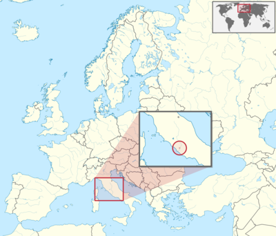
Vatican City Location in World Map
The Vatican is the smallest state in the world, both in terms of area and population. The small country is officially called “State of Vatican City”. But one also simply says the State of the Vatican or, for short, the Vatican.
The Vatican is located in the middle of Rome and is therefore an enclave in Italy. It is the seat of the Pope, the head of the Catholic Church. The Pope is also the head of state of the Vatican.
The Vatican is located in Rome in Italy.
Location Information of Vatican City
Vatican City, officially the Vatican City State, is an independent city-state enclaved within Rome, Italy. It is the smallest country in the world both by area and population. Vatican City serves as the spiritual and administrative center of the Roman Catholic Church and is the residence of the Pope. Its unique status as a sovereign entity is a result of the Lateran Treaty signed in 1929, which recognized its independence from Italy.
Latitude and Longitude
Vatican City is located at Latitude 41.9029° N and Longitude 12.4534° E. It is positioned on the western bank of the Tiber River, surrounded by the city of Rome. The Vatican’s location at the heart of Italy’s capital is symbolic of its influence in the Christian world and its deep historical ties to Rome.
Capital City and Major Cities
Capital City: Vatican City
The capital of Vatican City is, in fact, the city-state itself. As the smallest independent state in the world, Vatican City has no other cities or towns. The entire territory is contained within the 44 hectares (110 acres) that form the city-state, and it is entirely surrounded by the city of Rome, Italy. Vatican City houses the Pope, the leader of the Roman Catholic Church, and serves as the spiritual and administrative center of Catholicism.
Although it has no other cities, Vatican City is home to several significant structures and locations that hold deep religious, cultural, and historical importance, including St. Peter’s Basilica, St. Peter’s Square, and the Vatican Museums.
Time Zone
Vatican City operates on Central European Time (CET) during the standard time period, which is UTC +1. During the summer months, the country observes Central European Summer Time (CEST), which is UTC +2. The time zone alignment with Rome and the rest of Italy ensures uniformity across the region.
Economic Status
Vatican City has a unique and distinct economic profile due to its status as a city-state that is entirely dependent on donations and revenues from religious activities. Unlike other nations, Vatican City’s economy is primarily based on religious and cultural activities, as well as its investment portfolio. It is not a typical market-based economy, and the government of Vatican City does not levy taxes in the traditional sense.
Key Economic Factors:
- Donations and Religious Revenue The most significant source of income for Vatican City comes from the Catholic Church’s donations and charitable offerings. This includes collections taken during religious services, particularly those held in St. Peter’s Basilica or in St. Peter’s Square, where millions of pilgrims gather annually. Additionally, offerings for papal blessings contribute to the state’s income.
- Vatican Museums and Tourism The Vatican Museums are a major source of revenue for the country, as millions of visitors travel to Vatican City each year to view the extensive collection of art and historical artifacts. The museums include masterpieces by Michelangelo, Raphael, and Leonardo da Vinci, making it one of the most visited art collections in the world.
- Real Estate and Investments Vatican City holds a substantial investment portfolio, which includes real estate in Rome and around the world, stocks, and other financial assets. The Vatican’s wealth is also tied to its vast collection of precious artifacts, manuscripts, and artworks, some of which are priceless.
- Printing and Publishing The Vatican Press, or Tipografia Vaticana, is responsible for publishing papal writings, religious texts, and the Osservatore Romano (the Vatican newspaper). The Vatican also has a publishing arm known as Vatican Publishing House (Libreria Editrice Vaticana), which prints books, documents, and publications related to Catholic teachings and the Pope’s statements.
- Postal Services The Vatican operates its own postal system, known for its efficiency and its unique stamps, which are highly prized by philatelists (stamp collectors). The Vatican Post also plays a role in the economy, although it is a relatively small part of the overall revenue.
Despite its lack of traditional industries, Vatican City maintains a robust economy thanks to these diverse income sources, its religious status, and its historical significance.
Tourist Attractions
Vatican City is home to some of the most renowned landmarks and artistic treasures in the world. As the center of the Roman Catholic Church and a UNESCO World Heritage site, the country attracts millions of visitors each year.
1. St. Peter’s Basilica
St. Peter’s Basilica is the largest and most important church in the Christian world. Situated in St. Peter’s Square, the basilica is a masterpiece of Renaissance architecture and art, designed by renowned architects such as Michelangelo and Bernini. Visitors come to admire its grandeur, the famous Pietà sculpture by Michelangelo, and the magnificent dome that dominates the Vatican skyline.
2. St. Peter’s Square
St. Peter’s Square is a grand open space in front of St. Peter’s Basilica. The square is famous for its obelisk at the center, and its colonnades designed by Gian Lorenzo Bernini, which create a sense of embrace for those who enter. It is here that the Pope delivers his papal blessings and where major religious events, such as the Easter Mass, take place.
3. The Vatican Museums
The Vatican Museums are a vast complex of galleries and museums that house one of the most impressive art collections in the world. The museums contain works by famous artists, including Raphael, Leonardo da Vinci, and Caravaggio. The Sistine Chapel, located within the museums, is particularly renowned for Michelangelo’s stunning frescoes, including the famous Creation of Adam on the ceiling.
4. The Sistine Chapel
The Sistine Chapel is not only an artistic masterpiece but also serves as the location for the papal conclave, where a new pope is elected. The chapel’s ceiling, painted by Michelangelo between 1508 and 1512, is one of the most famous works of art in the world. The altar wall, also painted by Michelangelo, features the iconic Last Judgment fresco.
5. Vatican Gardens
The Vatican Gardens cover about half of Vatican City and are a peaceful retreat filled with lush greenery, fountains, and historical monuments. The gardens are not only beautiful but also offer visitors insight into the history of the Vatican and its religious and political significance. Access is typically by guided tour only.
6. The Apostolic Palace
The Apostolic Palace is the official residence of the Pope and is not typically open to the public, but it is an important historical building. The palace contains the Papal Apartments, the Vatican Library, and the Vatican Archives, which house some of the world’s most important historical documents.
Visa Requirements for U.S. Citizens
As Vatican City is located entirely within Italy, U.S. citizens do not need a separate visa to enter Vatican City. Since it is not a full-fledged country with its own visa regulations, entry to the Vatican is governed by Italy’s visa policies.
- Short Stays (Tourism or Business): U.S. citizens can visit Vatican City for tourism or business purposes for up to 90 days within a 180-day period without the need for a visa. This is based on the Schengen Area visa rules, as Vatican City is entirely surrounded by Italy, which is part of the Schengen Area.
- Long Stays or Residency: If a U.S. citizen wishes to stay in Vatican City for more than 90 days, they would need to follow Italian immigration laws, as the Vatican does not have its own immigration system. This would involve obtaining a long-term visa from Italy before traveling to the Vatican.
Vatican City does not impose entry requirements such as passport control for visitors, as it shares open borders with Italy. However, travelers should always carry their passports or identity cards for identification.
Distance to New York City and Los Angeles
- Distance from Vatican City to New York City The distance between Vatican City and New York City is approximately 6,800 kilometers (4,225 miles). Flights between the two cities typically take around 8 to 9 hours of direct travel time.
- Distance from Vatican City to Los Angeles The distance between Vatican City and Los Angeles is about 9,700 kilometers (6,035 miles). A direct flight typically takes about 11 to 12 hours, depending on flight conditions.
Vatican City, as an enclave within Rome, is easily accessible from Italy’s major cities, making it a central hub for Catholic pilgrims, tourists, and those seeking a glimpse into the heart of the Catholic faith.
Mountains
The Vatican is in the middle of Rome. It is partly surrounded by a wall. The most famous building in the Vatican is St. Peter’s Basilica with the large square in front of it, St. Peter’s Square. Other buildings are the Vatican Museums and the Apostolic Palace. This is where the Pope lives and there is also the Sistine Chapel, where a new Pope is elected.
The Vatican Gardens take up more than half of the national territory. There is a lot of lawn here, but also trees and flower beds.
Climate
The weather in the Vatican corresponds to that of Rome. In summer it is dry and hot, in winter it is mild and humid. The hottest month is July with an average of 25 degrees, the coldest is January with 7.8 degrees. Most of the rain falls between October and December.
Vatican City Facts
| Size | 0.44 km² |
| Residents | 1000 |
| Languages | Latin, Italian |
| Capital | – |
| Longest river | – |
| Highest mountain | Vatican Hill (75 m) |
| Currency | Euro |


