Benin Facts
Benin, State of West Africa; 112 600 km², 11.5 million residents (2019.Benin borders north to Niger, east to Nigeria, west to Togo and northwest to Burkina Faso and has a coast to the Atlantic in the south. The capital is Porto-Novo (263 600 residents, 2014).
Country facts
- Republic of Benin / Republic of Benin
- Country abbreviation: BJ
- Area: 112 600 km²
- Population (2019): 11.5 million residents
- Capital: Porto-Novo
- Main languages: French, fon
- State: Republic
- Head of State and Head of Government: Patrice Talon (President)
- Per capita GDP (2018): US $ 902
- GNI per capita (2018): US $ 870
- Currency unit: 1 CFA franc = 100 centimes
- Currency code: XOF
- Country number (telephony): 229
- Internet domain name: bj
- Time difference compared to Sweden: 0
- National Day: August 1 (Independence Day, 1960)
Nature
- Land use: agricultural land (16%), other (84%)
- Highest mountain: Sokbaro (658 m asl)
Population
- Population density (2019): 102 residents per km²
- Natural population growth (2019): 3.3%; birth rate 42 ‰, death rate 9 ‰
- Age structure (2019): 0-14 years (43%), 15-64 (54%), 65- (3%)
- Average life expectancy (2019): men 60 years, women 63 years
- Infant mortality (2019): 55 per 1,000 live births
- Population forecast 2050: 28 million residents
- HDI (2017): 0.515 (place 163 of 189)
- Urbanization rate (2019): 45%
- Most populous cities (2014): Cotonou (678 900 residents), Porto-Novo (263 600 residents)
Business
- Industry’s contribution to GDP (2017): agriculture (26%), industry (23%), service (51%)
- Exports (2017): US $ 1 974 million
- Main export products: cotton, cashew nuts, textiles
- Main exporting countries: Bangladesh, India, Ukraine
- Imports (2017): US $ 2,787 million
- Main import products: food, capital goods, oil products
- Main importing countries: Thailand, India, France
- Railway network (2014): 440 km
Geography
Location and Borders
Benin is a small country located in West Africa, bordered by Togo to the west, Nigeria to the east, and Burkina Faso and Niger to the north. The southern border of Benin lies along the Gulf of Guinea, giving it a small but significant coastline of about 121 kilometers. With an area of 112,622 square kilometers, Benin is relatively compact, but its diverse landscape and cultural richness make it one of the most interesting countries in the region.
The country’s geography is characterized by low-lying plains in the south, where the land meets the Atlantic Ocean, and a more undulating terrain in the north. The southern part of Benin is dominated by swamps, lagoons, and coastal plains, while the north features savannahs and forested areas. This variation in geography results in distinct ecological zones, from tropical rainforests in the south to dry, arid conditions in the northern part of the country.
Major Landforms
Benin’s landscape includes a wide array of natural features that define the country’s environment. In the south, the land is dominated by the coastal plains and the extensive wetlands surrounding the Ouémé River and the Niger River delta. These regions are crucial for agriculture, particularly rice farming and fishing, which are staples for the local population. The coastline, though relatively short, supports a number of coastal cities, including Cotonou, the country’s economic hub.
To the north, the terrain shifts to a more rolling landscape with savannahs and tropical forests, which gradually give way to the semi-arid Sahel region in the far northern parts. The Atakora Mountains, located along the country’s northern border with Burkina Faso and Togo, represent the highest elevation in Benin, with peaks reaching up to 658 meters above sea level. The mountains and hills in this region are covered with a mix of forests and savannah vegetation, making it an area of rich biodiversity.
Benin is also home to several rivers, including the Ouémé, which runs from the northeast down to the south, where it empties into the Atlantic Ocean. The Mono River, which forms part of the border with Togo, is another major waterway in the country. These rivers are vital for transportation, irrigation, and supporting the local ecosystem, providing resources for agriculture and wildlife.
Rivers and Lakes
The rivers of Benin are not only important for their practical use in transportation and agriculture but also for their environmental and economic significance. The Ouémé River is the largest and most significant river in Benin, flowing from the northern part of the country toward the south and emptying into the Gulf of Guinea. This river plays a critical role in agriculture, particularly in the fertile valleys it forms along its banks, where crops such as maize, rice, and cotton are cultivated.
The Mono River, which marks the boundary between Benin and Togo, is another key waterway that helps to define the geography of the region. The lake area near the southern coastal towns, including Lake Nokoué, is part of a larger network of lagoon systems that support the local fisheries and serve as a source of livelihood for many in the region.
Climate
Tropical Climate Zones
Benin’s climate is typically tropical, characterized by distinct wet and dry seasons. The climate varies depending on the region, with the southern coastal areas experiencing more rainfall and humidity, while the northern parts have a more arid climate due to their proximity to the Sahel region. In general, Benin experiences a warm climate year-round, with temperatures rarely dropping below 20°C, especially in the coastal areas, where humidity levels are higher.
The rainy season in Benin typically runs from April to October, while the dry season stretches from November to March. The southern region, which includes the economic capital of Cotonou, receives more rainfall than the northern areas. The annual rainfall can vary from 1,200 to 1,600 millimeters in the south, whereas the north, being closer to the desert, gets much less, with only about 900 millimeters of rain per year.
Wet and Dry Seasons
The wet season in Benin is influenced by the West African Monsoon, which brings moisture from the Atlantic Ocean and results in heavy rains, particularly in the southern and central parts of the country. These rains support the region’s agriculture, including the cultivation of crops such as cassava, yams, rice, and maize.
In the dry season, the harmattan winds, which come from the Sahara Desert, can affect the northern regions, lowering humidity levels and causing dust storms. This period can be harsh, particularly for agriculture in the north, where the dry season is longer and harsher. Despite this, the rainy season brings a time of prosperity for farmers in the south, allowing for multiple harvests throughout the year.
People
Demographics
Benin has a population of approximately 13.5 million people, making it one of the smaller countries in terms of population in West Africa. The population is ethnically diverse, with over 60 distinct ethnic groups spread across the country. The largest ethnic groups include the Fon, Adja, Yoruba, and Bariba, though smaller groups such as the Otamari, Dendi, and Peul (Fulani) also contribute to the rich cultural tapestry of the country.
The population is predominantly rural, with a significant portion of the people living in small villages and towns, particularly in the northern and central parts of the country. However, there are also larger urban centers, such as the capital city, Porto-Novo, and Cotonou, which is the country’s largest city and economic center.
Language and Religion
The official language of Benin is French, which is used in government, business, and education. However, many people in Benin speak local languages, which vary depending on the region. The most widely spoken local languages include Fon, Yoruba, and Bariba. Fon, in particular, is used by a large portion of the population in the south, while Yoruba is spoken by communities in the southwestern regions.
In terms of religion, Benin is home to a variety of faiths. The majority of the population is either Christian or Muslim, with the largest Christian denomination being Roman Catholicism, followed by Protestantism. The Muslim population, primarily in the north, practices Sunni Islam. There is also a significant number of people who adhere to traditional African religions, especially in rural areas. Vodun (Voodoo) is one of the most prominent traditional religions in Benin, with its roots deeply embedded in the culture and practices of the Fon and other ethnic groups in the south. The practice of Vodun is recognized as an official religion in the country.
Economy
Economic Overview
Benin’s economy is primarily based on agriculture, which employs a large portion of the population. The country’s agricultural sector produces a variety of crops, including cotton, maize, cassava, yams, and rice. Cotton is a key cash crop, and Benin is one of the largest producers of cotton in West Africa. The agricultural sector is heavily dependent on the climate and seasonal rainfall, which affects production and output.
Benin also has a relatively small but growing manufacturing sector, which includes the processing of agricultural products such as cotton, palm oil, and cashew nuts. In recent years, the government has made efforts to diversify the economy by developing the services sector, including telecommunications, banking, and tourism.
One of the most important economic activities in Benin is trade. The country serves as a key trading hub in the region, especially due to its proximity to Nigeria, the largest economy in Africa. Cotonou is home to one of the largest ports in West Africa, and it is a major center for importing and exporting goods, particularly oil, textiles, and agricultural products. The port is a crucial asset for the country’s economic growth and has made Benin an important player in regional trade.
Despite these opportunities, Benin remains one of the poorer countries in the region, with a significant portion of the population living below the poverty line. The country faces challenges related to infrastructure, education, and healthcare, but the government has focused on improving its economic situation through various reforms and investments.
Challenges and Opportunities
Benin faces challenges typical of many developing countries, including inadequate infrastructure, low industrial capacity, and limited access to quality healthcare and education. The country has also been affected by global economic fluctuations, such as changes in commodity prices and the impact of climate change on agricultural output.
However, Benin also has significant opportunities for growth. With its strategic location along the coast, the country has the potential to expand its role as a trade and logistics hub for the region. The government has recognized the importance of developing its human capital and has made investments in education and vocational training to better equip its workforce. Additionally, the tourism sector has been growing, with more visitors attracted by the country’s rich cultural heritage, including its Vodun traditions, historical sites, and natural landscapes.
Government
Political Structure
Benin is a constitutional democracy with a multi-party political system. The country is governed by a president, who serves as both the head of state and the head of government. The president is elected for a five-year term, with the possibility of re-election for one additional term. The legislative branch is a unicameral National Assembly, which consists of 83 members elected for five-year terms.
The judiciary in Benin is independent, and the country operates under a system of civil law. Benin has made significant strides toward political stability and democratic governance since its transition to democracy in the early 1990s, following years of military rule. The government emphasizes political pluralism, with several political parties active in the country, though the political landscape is dominated by a few large parties.
Political History
Benin’s political history is shaped by its colonial past and subsequent transition to independence. The country was a French colony until 1960, when it gained independence under the name Dahomey. Over the next few decades, Benin went through periods of political instability, with frequent changes in government, military coups, and Marxist-Leninist influences.
In 1990, Benin became one of the first countries in Africa to transition to multi-party democracy, following a peaceful national conference that led to the drafting of a new constitution and the holding of free elections. Since then, the country has maintained a relatively stable political environment, though challenges related to corruption, poverty, and political patronage remain. Benin’s democratic transformation is often seen as a model for other countries in the region.
Culture
Art and Music
Benin has a rich cultural heritage that reflects its diverse ethnic groups, religious traditions, and colonial history. The country is known for its vibrant arts, including traditional sculpture, textiles, and pottery. Beninese artists are particularly skilled in wood carving, creating intricate masks, statues, and figures that are often used in ceremonial practices.
Music and dance are integral parts of Beninese culture, with various genres reflecting the country’s ethnic diversity. Traditional music styles such as Gèlèdè, associated with the Fon people, involve elaborate drum rhythms and chanting. Benin is also known for its popular music scene, which blends traditional rhythms with modern genres like Afrobeat and reggae. Artists like Angélique Kidjo, one of Africa’s most celebrated musicians, have helped to bring Benin’s music to international prominence.
Festivals
Festivals in Benin are often rooted in religious and cultural traditions. Vodun festivals, celebrated primarily in the south, are marked by vibrant processions, music, dance, and the honoring of spirits. These festivals attract both locals and tourists and are a celebration of the country’s spiritual heritage.
The most important Vodun festival in Benin is the annual Fête du Vodoun, held in Ouidah, a town on the coast that was historically significant in the transatlantic slave trade. During the festival, devotees pay homage to Vodun deities, and rituals are performed by priests and priestesses.
Cuisine
Beninese cuisine reflects its agricultural base and the diversity of its people. Staples include rice, maize, yams, and cassava, which are often served with sauces made from vegetables, fish, or meat. Popular dishes include pâté (a maize dish served with tomato sauce or fish), atiéké (cassava couscous served with grilled fish or meat), and sauce d’arachide (peanut sauce, often served with rice or yam).
The cuisine of Benin is flavorful and often spicy, incorporating a variety of seasonings and herbs. The country is also known for its street food, which includes grilled meats, fried snacks, and local beverages like tchoukoutou (a fermented millet drink) and bitter cola (used in local rituals and as a stimulant).
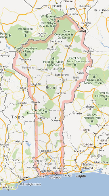
Benin Map