Where is Vanuatu Located?
Where is Vanuatu located on the map? Vanuatu is an independent nation located in Melanesia. Check out the following images to see location of Vanuatu on maps.
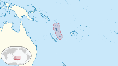
Vanuatu Location in World Map
Vanuatu means “Our Eternal Land” – a catchy-sounding name for the small island state that lies in the South Pacific and consists of 83 islands or archipelagos. Geographically, the area belongs to Melanesia. Of the 83 islands, 67 are inhabited. Most belong to the New Hebrides archipelago. The Bank and Torres Islands are also part of Vanuatu.
From the air, the small islands form the shape of a “Ypsilon”. You can see that very well on the adjacent map. The state stretches for 1,300 miles from the Torres Islands in the northwest to two small islands in the south called Hunter and Matthew.
Most of the islands are very small, and you’ve probably never heard of this state. The largest island is 3955.5 square kilometers and is called Espíritu Santo . The next larger island with just over 2000 square kilometers is called Malakula.
The highest point that can be found on Vanuatu is called Tabwemasana, a mountain at 1879 meters. It is located on the island of Espíritu Santo, the largest island in the small state. The total land area of Vanuatu is 12,190 square kilometers.
Here you can see the location of the small islands in the middle of the South Pacific.
Location Information of Vanuatu
Vanuatu is an island nation located in the South Pacific Ocean, situated approximately 1,750 kilometers (1,090 miles) east of northern Australia, 500 kilometers (310 miles) west of Fiji, and 1,000 kilometers (620 miles) northeast of New Caledonia. The country consists of around 83 islands, which are divided into six main provinces. Vanuatu is known for its stunning beaches, coral reefs, and tropical climate, making it a popular destination for nature lovers and adventure travelers.
Latitude and Longitude
Vanuatu is located between Latitude 13°S to 20°S and Longitude 166°E to 170°E. The nation’s position in the Pacific Ocean gives it a tropical maritime climate, characterized by warm temperatures year-round, with distinct wet and dry seasons.
Capital City and Major Cities
Capital City: Port Vila
The capital and largest city of Vanuatu is Port Vila, located on the island of Efate. Port Vila serves as the economic and political center of the country. It is the main gateway for visitors to Vanuatu and has a population of around 50,000 people. The city lies at Latitude 17.7333° S and Longitude 168.3192° E.
Port Vila is a vibrant town with a mix of modern facilities and traditional Melanesian culture. The city features a beautiful harbor, lively markets, and various historical landmarks. It also serves as the primary hub for transportation, trade, and tourism in the country. Visitors to Port Vila can enjoy a variety of activities, including diving, snorkeling, hiking, and exploring the local culture and cuisine.
Major Cities
- Luganville Luganville is the second-largest city in Vanuatu and is located on Espiritu Santo, the largest island in the country. Luganville is situated at Latitude 15.4892° S and Longitude 167.1916° E. The city serves as an important commercial and industrial center, with a focus on agriculture, fishing, and tourism. Luganville is also close to the famous Blue Hole, a natural freshwater sinkhole that attracts visitors for swimming and diving.
- Norsup Located on the island of Malekula, Norsup is a small town that serves as one of the economic centers of the island. Norsup is situated at Latitude 16.2500° S and Longitude 167.7167° E. The town is primarily engaged in agriculture, particularly the production of copra (dried coconut meat), which is an important export commodity for Vanuatu.
- Tanna Tanna is an island located in the southern part of Vanuatu. Its main settlement, also called Tanna, is home to around 3,000 people. Tanna is famous for its active volcano, Mount Yasur, one of the most accessible active volcanoes in the world. The island is a popular destination for adventure tourism and offers visitors the chance to witness spectacular volcanic eruptions and explore the island’s traditional villages.
Time Zone
Vanuatu operates on Vanuatu Time (VUT), which is UTC +11:00. The country does not observe daylight saving time, so the time remains the same throughout the year. This time zone places Vanuatu ahead of many Pacific nations and is consistent with other countries in the region, such as New Caledonia and Solomon Islands.
Economic Status
Vanuatu’s economy is heavily dependent on agriculture, tourism, and services. As a developing nation, it faces challenges such as limited infrastructure, vulnerability to natural disasters, and reliance on external aid. Despite these challenges, Vanuatu has experienced steady economic growth, particularly in the tourism sector, thanks to its beautiful landscapes, pristine beaches, and unique cultural offerings.
Key Sectors of the Economy:
- Agriculture Agriculture is a significant sector in Vanuatu, contributing to both domestic consumption and export. Copra (dried coconut meat), kava, and cocoa are some of the major agricultural products. Kava, in particular, is used in traditional ceremonies and also exported for use in beverages, particularly in the Pacific region. Agriculture employs a large portion of the population, especially in rural areas.
- Tourism Tourism is a major contributor to Vanuatu’s economy, with the country attracting visitors for its natural beauty, outdoor activities, and unique culture. The islands are famous for their volcanic landscapes, coral reefs, and world-class diving sites. Popular tourist activities include snorkeling, scuba diving, hiking, and exploring traditional villages. Port Vila, Luganville, and the island of Tanna are among the top tourist destinations. The country is also known for being a safe and relatively untouched destination for eco-tourism.
- Services and Finance The services sector is important, particularly in the areas of banking, finance, and real estate. Vanuatu has become an attractive location for offshore financial services due to its favorable tax policies and business regulations. The country offers low taxes and has a growing reputation as an offshore financial center. However, the sector is relatively small compared to agriculture and tourism.
- Fishing Vanuatu’s fishing industry is another vital part of its economy, especially tuna fishing. The country has rich marine resources, and fishing is an important export commodity. The fisheries sector also supports a significant portion of the population, providing both food and income.
Challenges:
Despite its economic potential, Vanuatu faces challenges such as a small domestic market, limited industrial capacity, and vulnerability to natural disasters, including tropical cyclones, earthquakes, and volcanic eruptions. Climate change and rising sea levels are also concerns for the island nation, threatening both its agricultural output and coastal infrastructure.
Tourist Attractions
Vanuatu’s tourism industry is driven by its diverse natural landscapes, traditional culture, and unique experiences, particularly for those interested in adventure, eco-tourism, and cultural immersion.
1. Mount Yasur
Mount Yasur, located on the island of Tanna, is one of the most famous tourist attractions in Vanuatu. Known as one of the most accessible active volcanoes in the world, Yasur offers visitors the chance to witness regular volcanic eruptions and a spectacular landscape. Tourists can take guided tours to the summit and observe the lava flows and explosions from a safe distance.
2. The Blue Hole
Located on the island of Espiritu Santo, the Blue Hole is a natural freshwater spring that is famous for its crystal-clear waters and stunning blue color. The Blue Hole is a popular spot for swimming, snorkeling, and diving, and is considered one of the best dive sites in the Pacific. The surrounding area is lush and tropical, adding to the site’s allure.
3. Vanuatu National Museum and Cultural Center
The Vanuatu National Museum and Cultural Center in Port Vila showcases the history, culture, and traditions of the Vanuatu people. Visitors can learn about the indigenous Melanesian culture, including traditional crafts, ceremonies, and the role of kava in local society. The museum is a valuable resource for understanding the heritage of the island nation.
4. Pentecost Island
Pentecost Island is known for its traditional land diving ceremonies, which involve participants jumping from wooden platforms up to 30 meters above the ground with vines tied around their ankles. This ancient practice is a key cultural ritual for the indigenous people of Pentecost and attracts many visitors who come to witness the bravery and tradition behind the ceremony.
5. Espiritu Santo
The island of Espiritu Santo is known for its beautiful beaches, clear blue waters, and world-class dive sites. The island is also home to the SS President Coolidge, a World War II American shipwreck that is now one of the top diving sites in the world. The island’s lush rainforests, waterfalls, and villages offer opportunities for hiking, cultural experiences, and eco-tourism.
6. Efate Island
Efate Island, where Port Vila is located, is home to pristine beaches, coral reefs, and traditional villages. Tourists can visit the island’s numerous diving and snorkeling spots, hike through the island’s lush interior, or explore the vibrant markets and restaurants in Port Vila. Mele Cascades, a stunning waterfall located near Port Vila, is another popular attraction.
Visa Requirements for U.S. Citizens
U.S. citizens can visit Vanuatu without a visa for short stays, such as tourism or business trips. U.S. visitors are typically granted a stay of up to 30 days upon arrival, and the visa can be extended if necessary. However, travelers should ensure that their passport is valid for at least six months beyond their planned departure date and that they have a return ticket or proof of onward travel.
In some cases, U.S. citizens may be required to show proof of sufficient funds to cover their stay, but this is generally not a strict requirement for most tourists. It is always a good idea to check with the Vanuatu High Commission or nearest consulate before traveling for the most current visa and entry requirements.
Distance to New York City and Los Angeles
- Distance from Port Vila to New York City The distance between Port Vila and New York City is approximately 16,000 kilometers (9,940 miles). Flights typically take around 20-22 hours, depending on layovers and the flight route.
- Distance from Port Vila to Los Angeles The distance between Port Vila and Los Angeles is about 12,500 kilometers (7,775 miles). A flight from Port Vila to Los Angeles typically takes around 15-17 hours, depending on layovers.
Vanuatu Facts
| Size | 12,190 km² |
| Residents | 250,000 |
| Languages | French, English and Bislama |
| Capital | Port Villa |
| Longest river | Le Jourdain |
| Highest mountain | Tabwemasana (1,877 m) |
| Currency | Vatu |


