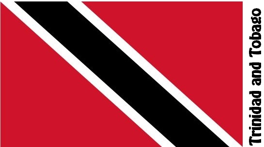
Trinidad and Tobago Facts
Trinidad and Tobago, State of the Caribbean; 5 128 km², 1.4 million residents (2019).Trinidad and Tobago consist of two islands. The main island of Trinidad (4,828 km² ), the largest island in the Little Antilles, is located about 25 km east of Venezuela’s coast. Tobago (300 km² ) is located about 30 km northeast of Trinidad. The capital is Port of Spain (50,400 residents, 2012) in Trinidad.
Country facts
- Republic of Trinidad and Tobago / Republic of Trinidad and Tobago
- Country abbreviation: TT
- Area: 5 128 km²
- Population (2019): 1.4 million residents
- Capital: Port of Spain
- Main language: English
- State: Republic
- Head of State: Paula-Mae Weekes (President)
- Head of Government: Keith Rowley
- Per capita GDP (2018): US $ 16,844
- GNI per capita (2018): US $ 16,240
- Currency unit: $ 1 = 100 cents
- Currency code: TTD
- Country number (telephony): 1
- Internet Domain Name: tt
- Time difference compared to Sweden: −5
- National Day: August 31 (Independence Day, 1962)
Nature
- Land use: forest (46%), agricultural land (24%), other (30%)
- Highest mountain: Aripo (940 m asl)
Population
- Population density (2019): 273 residents per km²
- Natural population growth (2019): 0.5%; birth rate 13 ‰, death rate 8 ‰
- Age structure (2019): 0-14 years (21%), 15-64 (72%), 65- (7%)
- Average life expectancy (2019): men 71 years, women 76 years
- Infant mortality (2019): 17 per 1,000 live births
- Population forecast 2050: 1 million residents
- HDI (2017): 0.784 (place 69 of 189)
- Urbanization rate (2019): 53%
- Most popular cities (2012): Chaguanas (79,400 residents), San Fernando (57,600), San Juan (56,500)
Business
- Industry’s contribution to GDP (2017): industry (48%), service (52%)
- Exports (2017): US $ 9,927 million
- Main export products: oil, gas, chemicals
- Main exporting countries: USA, Argentina
- Imports (2017): US $ 6 105 million
- Main import products: Fuel, machinery, transport equipment
- Main importing countries: USA, Russian Federation, Colombia
- Railway network: nothing in operation
Geography of Trinidad and Tobago
Location and Borders
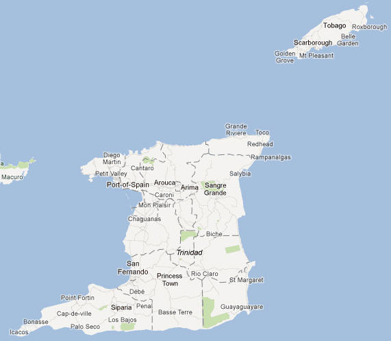
Trinidad and Tobago is an island nation located in the Caribbean Sea, off the northeastern coast of Venezuela. Trinidad, the larger of the two islands, lies just 11 kilometers (7 miles) off the Venezuelan coast, while Tobago is situated to the northeast of Trinidad, approximately 30 kilometers (19 miles) away. This strategic location makes Trinidad and Tobago one of the southernmost countries in the Caribbean.
The nation comprises two main islands: Trinidad, which accounts for about 93% of the country’s total land area, and Tobago, a smaller island. Both islands are separated by the Gulf of Paria, a body of water that serves as a natural boundary between Trinidad and the South American mainland. Trinidad and Tobago also includes several smaller islands, such as Chacachacare, Monos, and Little Tobago.
Terrain and Landscape
The geography of Trinidad and Tobago is diverse, characterized by coastal plains, mountains, and lush rainforests. Trinidad’s landscape is primarily mountainous in the north, with the Northern Range stretching along the northern part of the island. The highest peak in Trinidad is El Cerro del Aripo, which rises to 940 meters (3,084 feet) above sea level. The island’s southern and central regions are made up of fertile plains and wetlands, which are crucial for agriculture.
Tobago, although smaller, features a similarly varied landscape, with rolling hills and mountains in the central and northern parts of the island. The island is known for its coral reefs and beautiful beaches. Its highest peak, Pigeon Peak, stands at 550 meters (1,804 feet). The islands’ varied terrains contribute to the country’s rich biodiversity, offering an abundance of wildlife and plant species.
Water Bodies
Both islands are surrounded by several bodies of water, including the Caribbean Sea to the west and the Atlantic Ocean to the east. The Gulf of Paria and the Columbus Channel are significant bodies of water separating Trinidad from Venezuela and Tobago from the mainland. The islands are also home to several rivers, including the Caroni and Oropouche Rivers in Trinidad, which play an important role in the island’s water system. Additionally, the island of Tobago features several lagoons and sheltered bays that are critical for marine life and local economies.
Climate of Trinidad and Tobago
Tropical Climate
Trinidad and Tobago enjoys a tropical climate with distinct wet and dry seasons. The average temperature throughout the year typically ranges from 24°C (75°F) at night to 31°C (88°F) during the day. The islands are generally warm and humid, with temperatures reaching their peak during the dry season, from January to May. The coastal areas tend to be slightly cooler due to sea breezes.
Wet Season
The wet season lasts from June to December and is characterized by heavy rainfall, particularly in the mountainous areas of Trinidad. The rainfall is typically higher in the northern and eastern parts of the islands, with the Northern Range experiencing frequent afternoon showers. The wet season is also marked by the occasional occurrence of tropical storms or hurricanes, although Trinidad and Tobago are situated outside the typical hurricane belt. Despite this, the islands can still be affected by storms originating in the Atlantic or the Caribbean.
Dry Season
The dry season is from January to May and is the most pleasant time of year, with less rainfall, lower humidity, and a steady trade wind breeze. This season is characterized by clear skies and more comfortable temperatures, making it the peak tourist season.
People of Trinidad and Tobago
Population and Demographics
Trinidad and Tobago has a population of approximately 1.4 million people, making it one of the smaller nations in the Caribbean in terms of population. The country is a melting pot of ethnicities, reflecting its history of colonization, migration, and cultural exchange. The population is ethnically diverse, with significant communities of East Indian, African, European, Chinese, and Middle Eastern descent.
The largest ethnic group is of African descent, constituting about 37% of the population, while people of East Indian descent make up approximately 35%. The remaining population includes a mix of people of European, Middle Eastern, and Chinese ancestry, along with indigenous groups, including the Amerindian descendants.
English is the official language of Trinidad and Tobago, though the country’s cultural diversity is reflected in the variety of languages spoken. Creole, a blend of English, African, and Caribbean influences, is widely spoken, particularly in informal settings. Additionally, many people speak Hindi, Urdu, and Tamil, reflecting the influence of the large Indo-Trinidadian population.
Religion
Religious diversity is a hallmark of Trinidad and Tobago. The majority of the population practices Christianity, with Roman Catholicism and Protestantism being the most common denominations. However, significant communities of Hindus and Muslims also live in the country, reflecting the cultural influence of the Indian population. The country celebrates religious festivals from a variety of traditions, including Christmas, Eid al-Fitr, Divali, and Holi.
Urbanization and Rural Areas
Trinidad and Tobago is highly urbanized, with most of the population living in urban areas, particularly in and around the capital, Port of Spain, located on the west coast of Trinidad. Port of Spain is the country’s commercial, political, and cultural hub. Other major cities include San Fernando and Arima in Trinidad and Scarborough in Tobago. Rural areas, particularly in the central and eastern parts of Trinidad, remain less developed, and many people in these regions depend on agriculture for their livelihood.
Economy of Trinidad and Tobago
Key Economic Sectors
The economy of Trinidad and Tobago is one of the most developed in the Caribbean. It is heavily reliant on natural resources, particularly oil and natural gas, which constitute the majority of the country’s exports. Trinidad and Tobago has one of the largest reserves of oil and gas in the Caribbean region, and the energy sector plays a crucial role in the nation’s economic growth.
In addition to oil and gas, the manufacturing sector contributes significantly to the economy, with industries such as petrochemicals, food processing, and cement production playing major roles. The country is a major exporter of chemicals and fertilizer, derived from its rich oil and gas resources.
Tourism also plays a key role in the economy, with both islands attracting millions of visitors each year, especially during the dry season. While Tobago is known for its pristine beaches, diving opportunities, and eco-tourism, Trinidad is famous for its vibrant cultural festivals, particularly the annual Carnival, which attracts visitors from around the world.
Agriculture
Agriculture, while no longer as dominant as it once was, still plays an important role in the country’s economy. Key agricultural products include sugar, cocoa, coffee, rice, and various tropical fruits and vegetables. The country also has a thriving fishing industry, particularly along the coasts of both Trinidad and Tobago.
Challenges and Economic Diversification
Despite its relatively high-income status in the Caribbean, Trinidad and Tobago faces several economic challenges. These include overdependence on the oil and gas sector, which is vulnerable to global price fluctuations, and a high unemployment rate, particularly among young people. The government has been working to diversify the economy by focusing on sectors like manufacturing, technology, and renewable energy.
Government and Politics
Political Structure
Trinidad and Tobago operates as a parliamentary democracy and a constitutional republic. The government is based on the Constitution of Trinidad and Tobago, which was enacted in 1976. The political system is divided into three branches: the Executive, the Legislature, and the Judiciary.
The President of Trinidad and Tobago serves as the head of state, but the role is largely ceremonial. The President is elected by the Electoral College, which is made up of members of the National Assembly. The Prime Minister, who is the head of government, is the leader of the majority party in the House of Representatives and is responsible for the day-to-day operations of the government.
Legislative Branch
The legislative branch of Trinidad and Tobago is bicameral, consisting of the House of Representatives and the Senate. The House of Representatives has 41 members who are elected through general elections, while the Senate consists of 31 members, who are appointed by the President on the advice of the Prime Minister and the Leader of the Opposition.
Judicial Branch
The judicial system of Trinidad and Tobago is based on English common law and is independent from the other branches of government. The highest court in the country is the Privy Council in London, although efforts have been made to establish a local Court of Appeal. The judiciary is responsible for interpreting laws and ensuring the protection of citizens’ rights.
Political History
Trinidad and Tobago gained independence from the United Kingdom on August 31, 1962, and became a republic in 1976. Since independence, the country has had a relatively stable political environment, though it has experienced periods of political turmoil, particularly in the 1970s when there were protests and uprisings. The country has had peaceful transitions of power and has held regular elections.
Culture of Trinidad and Tobago
Music and Dance
Music is an integral part of Trinidad and Tobago’s cultural identity. The country is known for the creation of genres such as calypso and soca music, which are popular across the Caribbean. Carnival, held annually in Trinidad, is a grand celebration of music, dance, and colorful costumes, attracting tourists from all over the world. Steelpan music, invented in Trinidad in the 1930s, is another hallmark of the nation’s musical heritage, with steelpan bands performing at both local and international events.
Festivals
Trinidad and Tobago is home to numerous festivals throughout the year, with the most famous being Carnival. Held annually before Lent, Carnival features elaborate parades, masquerades, and vibrant street parties. Other important festivals include Divali (the Hindu festival of lights), Eid al-Fitr (celebrated by the Muslim population), and Christmas, which is celebrated with family gatherings, festive music, and traditional foods.
Cuisine
Trinidad and Tobago’s cuisine reflects the diverse cultural influences in the country. The food is a blend of African, Indian, European, and Chinese flavors. Popular dishes include roti (Indian flatbread filled with curried meats or vegetables), pelau (a rice dish made with chicken, beef, or pork), and doubles (a type of street food made with curried chickpeas). Seafood is also a major part of the diet, with dishes like callaloo (a soup made from dasheen leaves) and fish and bake being popular among locals.
Arts and Literature
Trinidad and Tobago has a rich tradition of arts and literature, with prominent writers such as V.S. Naipaul and Earl Lovelace contributing to the country’s literary reputation. Visual arts also have a prominent place in the nation’s culture, with numerous artists and galleries celebrating the vibrant heritage of the islands.
History of Trinidad and Tobago
Indigenous Peoples and Early Colonization
Before European arrival, Trinidad was inhabited by indigenous groups such as the Arawaks and Caribs. The first European to visit Trinidad was Christopher Columbus, who arrived in 1498. The Spanish colonized Trinidad and Tobago in the 16th century, though they did not settle the islands extensively. The French later settled Tobago, and both islands saw an influx of enslaved Africans who worked on sugar plantations.
British Rule
In the 19th century, both Trinidad and Tobago were ceded to Britain, and the islands became part of the British Empire. The islands remained colonies until they gained independence in 1962, and during this period, African slaves were replaced with indentured laborers, primarily from India.
Independence and Modern Era
Trinidad and Tobago achieved independence from Britain in 1962 and became a republic in 1976. The country has since made significant strides in economic development, cultural expression, and political stability, though challenges remain as it continues to work toward diversifying its economy and improving social equality. The history of Trinidad and Tobago reflects the complexities of its diverse population and its resilience in overcoming colonial legacies.
Trinidad and Tobago Map