Solomon Islands Facts
The Solomon Islands, state of the western Pacific, east of New Guinea; 27,556 km², 653,000 residents (2019).Solomon Islands encompasses most of the archipelago of the same name as well as Ontong Java, Rennell and Santa Cruz islands, a total of 21 larger and about 900 smaller islands. The capital is Honiara (66,200 residents, 2012) on Guadalcanal.

Country facts
- Solomon Islands / Solomon Islands
- Country abbreviation: SB
- Area: 27 556 km²
- Population (2019): 653,000 residents
- Capital: Honiara
- Main language: English
- State: Monarchy
- Head of State: Elizabeth II (Queen)
- Head of Government: Rick Houenipwela
- Per capita GDP (2018): US $ 2,163
- GNI per capita (2018): US $ 2,000
- Monetary Unit: Salomon 1 dollar = 100 cents
- Currency code: SBD
- Country Number (Telephony): 677
- Internet domain name: sb
- Time difference compared to Sweden: +10
- National Day: July 7 (Independence Day, 1978)
Nature
- Land use: forest (88%), agricultural land (2%), other (10%)
- Highest mountain: Makarakomburu (2,447 m asl)
Population
- Population density (2019): 24 residents per km²
- Natural population growth (2019): 2.5%; birth number 30 ‰, death number 5 ‰
- Age structure (2019): 0-14 years (40%), 15-64 (56%), 65- (4%)
- Average life expectancy (2019): men 67 years, women 74 years
- Infant mortality (2019): 19 per 1,000 live births
- Population forecast 2050: 1 million residents
- HDI (2017): 0.546 (place 152 of 189)
- Urbanization rate (2019): 24%
- Most populous city (2012): Honiara (66,200 residents)
Business
- Industry’s contribution to GDP (2017: agriculture (34%), industry 8%), service (58%)
- Exports (2017): US $ 469 million
- Main export products: timber, fish
- Main exporting countries: China, Italy
- Imports (2017): US $ 462 million
- Main import products: food, machinery, fuel
- Main importing countries: China, Australia, Singapore
- Railway network: nothing in operation
Geography of Solomon Islands
Location and Size
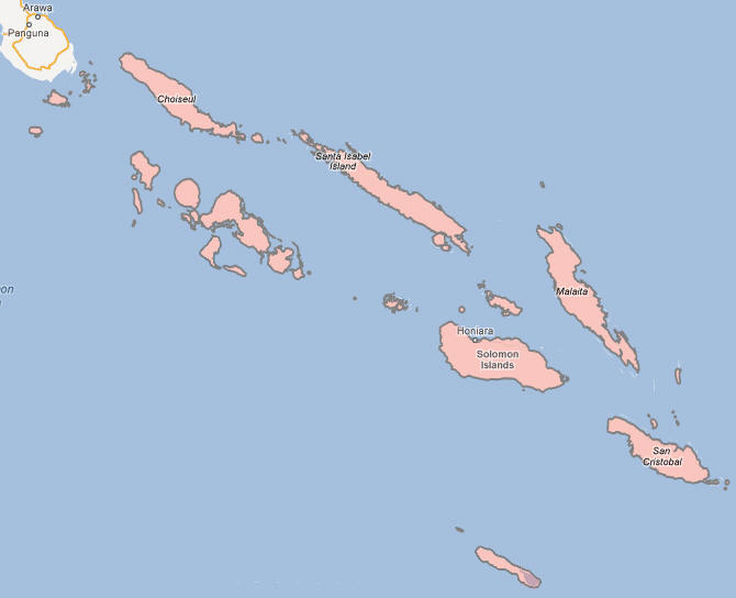
The Solomon Islands is a country located in the South Pacific Ocean, east of Papua New Guinea and northeast of Australia. The country consists of a group of more than 900 islands, with six major islands and numerous smaller ones. These islands stretch over an area of approximately 1,340 kilometers (832 miles) from east to west. The total land area of the Solomon Islands is about 28,400 square kilometers (10,967 square miles), making it one of the larger island nations in the Pacific.
The Solomon Islands is positioned on the Pacific Ring of Fire, a region known for its seismic and volcanic activity. The country is divided into several provinces, with Guadalcanal being the largest and most populous. The capital city, Honiara, is located on Guadalcanal Island and serves as the political and economic center of the country. Other significant islands include Malaita, Choiseul, and the Santa Cruz Islands.
Topography and Natural Features
The Solomon Islands features a highly varied landscape, with rugged mountains, dense rainforests, and beautiful coastlines. The topography of the islands is largely volcanic, and many of the islands are mountainous, particularly in the central and eastern parts. The highest point in the country is Mount Tabwemasana on Guadalcanal, which rises to 2,335 meters (7,661 feet) above sea level. The islands are also home to numerous rivers, lakes, and waterfalls, which are important for the local ecosystem and agriculture.
The country has a diverse array of ecosystems, from coastal mangroves and coral reefs to tropical rainforests that cover much of the interior. The Solomon Islands’ coastline is known for its stunning beaches and shallow lagoons, which are home to vibrant coral reefs and marine life, making it a popular destination for diving and eco-tourism. The country’s forests are home to many endemic species of plants and animals, contributing to its biodiversity.
The Solomon Islands is also part of the Pacific “Ring of Fire,” meaning it is prone to volcanic eruptions and earthquakes. In fact, the country experiences frequent seismic activity due to the movement of tectonic plates in the region. This activity has shaped the islands’ geography, creating both natural beauty and challenges for infrastructure development.
Climate of Solomon Islands
Tropical Climate
The Solomon Islands has a tropical climate, characterized by consistently high temperatures, high humidity, and significant rainfall throughout the year. The temperature typically ranges between 23°C (73°F) and 31°C (88°F), with only small variations between seasons. The climate is influenced by the islands’ proximity to the equator and its position in the South Pacific, which results in warm conditions year-round.
Wet and Dry Seasons
The Solomon Islands experiences a wet season and a dry season, with the wet season running from November to April. During the wet season, the islands receive heavy rainfall, which can sometimes cause flooding in low-lying areas. This season is also characterized by high humidity and frequent tropical storms or cyclones, particularly in the months of January to March. Cyclones can cause significant damage to infrastructure and homes in the region, though advances in weather forecasting have improved the ability to prepare for these events.
The dry season, which lasts from May to October, is marked by lower rainfall and cooler temperatures. However, even during the dry months, the country still experiences periods of rainfall, especially in the more mountainous regions. The dry season is typically considered the best time to visit the Solomon Islands for outdoor activities, as the weather is more conducive to travel and exploration.
Rainfall and Winds
Rainfall in the Solomon Islands is abundant, with the annual total varying from around 2,000 millimeters (79 inches) in some parts of the islands to over 3,500 millimeters (138 inches) in the more mountainous regions. The high rainfall supports the country’s tropical rainforests, making agriculture an important part of the economy. The rainfall is not evenly distributed, with the western islands generally experiencing more rain than the eastern parts.
The winds in the Solomon Islands are influenced by the Pacific Trade Winds, which blow from the east and northeast. These winds are generally moderate but can become more intense during the wet season, especially during tropical storms and cyclones. The country also experiences occasional monsoonal winds that bring heavy rain and strong gusts, particularly in the wet season.
People of Solomon Islands
Population and Demographics
The population of the Solomon Islands is around 700,000 people, with the majority of the population residing in rural areas. The country’s population is ethnically diverse, with over 70 distinct languages spoken across the islands. The largest ethnic group is Melanesian, which makes up about 95% of the population. Other ethnic groups include Polynesians and Micronesians, with smaller numbers of expatriates, including Chinese and Europeans, particularly in urban areas.
Solomon Islanders are predominantly young, with a median age of about 22 years. The country’s population has been growing steadily in recent decades, though the growth rate has slowed in recent years due to emigration and the challenges posed by the country’s infrastructure and development issues.
Urbanization in the Solomon Islands is limited, with most people living in rural communities spread across the many islands. The capital city, Honiara, is the largest urban center, but even here, the population is relatively small, and much of the country remains sparsely populated, with isolated villages in remote areas.
Language and Religion
English is the official language of the Solomon Islands, though it is spoken by only a small portion of the population as a first language. The majority of the population speaks one of the many local languages, with Melanesian Pidgin being the most widely spoken lingua franca. There are over 70 indigenous languages spoken in the country, reflecting its cultural and linguistic diversity. These languages vary from island to island, with some languages being spoken only by small, isolated communities.
Christianity is the dominant religion in the Solomon Islands, with the majority of the population identifying as Protestant (mostly Anglican and Methodist). There are also small Catholic and indigenous Christian communities. Religion plays a central role in the daily life of many Solomon Islanders, and church activities are an integral part of community life. Traditional animist beliefs and practices still exist, particularly in rural areas, but Christianity has become the predominant faith.
Education and Health
Education in the Solomon Islands is free and compulsory for children between the ages of 6 and 14. The country has made significant progress in improving access to education, though challenges remain, particularly in rural areas. Access to quality education is limited in many parts of the country due to infrastructure problems, lack of qualified teachers, and a shortage of educational materials. The government and various international organizations are working to improve the education system by building schools, improving teacher training, and making education more accessible.
Healthcare in the Solomon Islands is provided by a mix of public and private institutions, but access to healthcare services is uneven, with rural areas particularly underserved. The country faces a number of health challenges, including high rates of infectious diseases such as malaria, tuberculosis, and diarrhea, as well as issues related to maternal and child health. The government is focused on improving healthcare services, and there have been efforts to build and upgrade health facilities, particularly in urban areas. Despite these efforts, healthcare remains a significant challenge for many Solomon Islanders, particularly in remote regions.
Economy of Solomon Islands
Key Industries
The economy of the Solomon Islands is primarily based on natural resources, including agriculture, forestry, and mining. The country’s main exports include timber, palm oil, cocoa, copra (dried coconut), and fish. Agriculture is a key source of livelihood for most people, particularly in rural areas where subsistence farming is common. Cocoa and copra are important cash crops, with exports contributing significantly to the country’s GDP.
Fishing, particularly tuna fishing, is another vital industry in the Solomon Islands, with the country’s rich marine resources providing a significant source of income. The Solomon Islands is one of the world’s largest producers of tuna, and fishing plays a major role in the economy, both for domestic consumption and export.
Tourism is a growing sector of the economy, with visitors attracted by the country’s beautiful landscapes, coral reefs, and World War II historical sites. The government has been working to develop the tourism infrastructure, including improving transportation, building hotels, and promoting eco-tourism. However, the country’s remote location and limited infrastructure pose challenges to the growth of the tourism sector.
Economic Challenges
The Solomon Islands faces several significant economic challenges. The country remains one of the poorest in the Pacific region, with a high level of poverty, particularly in rural areas. Economic growth has been slow, and the country is highly dependent on foreign aid and remittances from the large Solomon Islander diaspora living abroad, especially in Australia and New Zealand.
The lack of infrastructure is one of the major hurdles to economic development, with many parts of the country lacking reliable roads, electricity, and telecommunications. The economy is also vulnerable to external factors such as global commodity price fluctuations and natural disasters. The Solomon Islands is prone to tropical cyclones, earthquakes, and other environmental hazards that can cause significant damage to infrastructure and agricultural production.
Another issue facing the country is political instability, which has historically been a major barrier to economic development. The Solomon Islands experienced civil unrest in the late 1990s and early 2000s, particularly related to ethnic tensions between different groups. While the country has enjoyed greater political stability in recent years, concerns about governance, corruption, and the capacity of the government to manage resources remain.
Government of Solomon Islands
Political System
The Solomon Islands is a constitutional monarchy with a parliamentary system of government. The country is a member of the Commonwealth, with the British monarch serving as the ceremonial head of state. The monarch is represented in the Solomon Islands by a governor-general, who is appointed by the British monarch on the advice of the Solomon Islands government.
The executive power in the country lies with the prime minister, who is the head of government. The prime minister is elected by members of the National Parliament and is responsible for forming a government and implementing policy. The National Parliament consists of 50 members who are elected for a four-year term through a mixed-member proportional representation system. The parliament is responsible for passing laws, approving the budget, and overseeing the actions of the government.
The judicial system in the Solomon Islands is based on English common law and is independent of the executive and legislative branches. The country’s highest court is the High Court, and the Solomon Islands also has a Court of Appeal.
Legal System
The legal system of the Solomon Islands is based on common law, with influences from English law, customary law, and the laws of Australia and New Zealand. The judiciary is independent, and the legal system provides mechanisms for the protection of individual rights, including property rights and the rule of law. The country has a range of courts, including the Magistrates Court, the High Court, and the Court of Appeal, which has jurisdiction over appeals from lower courts.
Customary law, which reflects the traditions and practices of local communities, also plays a significant role in the legal system, particularly in rural areas where traditional leaders or chiefs may be involved in dispute resolution. The legal system in the Solomon Islands faces challenges, including delays in court proceedings, limited access to legal services in rural areas, and a shortage of trained legal professionals.
Culture of Solomon Islands
Arts and Music
The Solomon Islands has a rich cultural heritage, with traditions that vary significantly across its many islands. Music, dance, and storytelling are central to the cultural life of the Solomon Islands, with traditional performances often featuring drumming, singing, and dancing. Many island communities maintain their own distinct forms of music, and the use of handmade instruments such as bamboo flutes, drums, and shell trumpets is common in ceremonial settings.
Art in the Solomon Islands includes wood carving, basket weaving, and the creation of traditional artifacts such as canoes and shields. Each community has its own distinctive art style, with motifs reflecting local beliefs, nature, and history. The Solomon Islands also has a growing contemporary arts scene, with artists increasingly drawing on both traditional and modern influences to create new works.
Festivals and Traditions
Slovenian culture is rich in traditions and festivals, many of which are tied to religious and seasonal events. One of the most widely celebrated festivals is Christmas, which is marked by traditional Slovak customs, including special foods, songs, and Christmas markets.
Solomon Islands Map