Where is Chad Located?
Where is Chad located on the map? Chad is an independent nation located in Central Africa. Check out the following images to see location of Chad on maps.
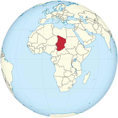
Chad Location in World Map
On the Karet you can see that Chad is in Central Africa.
Location Information of Chad
Chad is a landlocked country located in north-central Africa. It is bordered by Libya to the north, Sudan to the east, the Central African Republic to the south, Cameroon and Nigeria to the southwest, and Niger to the west. The country spans a diverse range of landscapes, from the vast desert regions in the north to the savannahs and woodlands in the south, with the central region being marked by the Chad Basin.
Latitude and Longitude
Chad is located at approximately 12.6° N latitude and 18.0° E longitude. Its central location in Africa places it at a crossroads between the Sahara Desert to the north and the more tropical regions of central Africa to the south. Chad’s geographical position, far from the coast and surrounded by various neighboring countries, contributes to its landlocked status and its reliance on neighboring nations for trade routes.
Capital City and Major Cities
Capital City: N’Djamena
The capital city of Chad is N’Djamena, situated in the western part of the country, near the Chari River. N’Djamena serves as the political, economic, and cultural hub of Chad. With a population of over 1 million people, it is by far the largest city in the country and acts as the primary center of government, business, and commerce. N’Djamena is also home to various government offices, international embassies, and cultural institutions.
N’Djamena’s location on the banks of the Chari River has historically made it an important trade and transport hub, particularly for goods coming from neighboring countries like Cameroon, Sudan, and the Central African Republic. The city has grown steadily over the years, despite challenges posed by the country’s political instability and underdeveloped infrastructure.
Major Cities
- Moundou Moundou is Chad’s second-largest city and is located in the southern part of the country, in the Logone Occidental region. It is an important economic and agricultural center, particularly known for its cotton production. Moundou has an estimated population of around 300,000 people and plays a key role in Chad’s agricultural economy. The city is well-connected to N’Djamena and serves as a trade hub for agricultural products like cotton, rice, and peanuts.
- Sarh Sarh is located in the southern part of Chad, along the Logone River, and serves as an important administrative and economic center for the country’s southern region. It is the capital of the Sarh Region and has a population of about 150,000 people. Sarh is a key location for the country’s cotton industry, with large-scale cultivation of the crop. The city is known for its agricultural trade and is also a gateway to the southern regions of Chad.
- Abéché Abéché is located in the eastern part of Chad, near the border with Sudan. The city has a population of about 200,000 people and plays a significant role in trade between Chad and Sudan. It is also important for the regional administration of the Ouaddaï region and is known for its proximity to the Saharan desert, which influences its climate and economy.
- Kélo Kélo is a smaller city in the southern part of Chad, located near the border with the Central African Republic. It has a population of around 50,000 people and serves as an agricultural center for the surrounding region. The city is important for the cultivation of crops such as cotton, rice, and millet.
Time Zone
Chad follows the West Africa Time (WAT) zone, which is UTC +1. This time zone places Chad one hour ahead of Coordinated Universal Time (UTC) and aligns with many other countries in the region, including Cameroon, Nigeria, and Niger. Chad does not observe Daylight Saving Time (DST), meaning that the time remains consistent throughout the year.
Climate
Chad’s climate is primarily hot and dry, with significant variation between the northern desert regions and the more temperate southern regions.
Temperature
Temperatures in Chad can vary widely depending on the region. In the northern desert regions, temperatures are extremely high, with summer temperatures regularly exceeding 40°C (104°F). The central and southern regions experience more moderate temperatures, with average highs ranging from 25°C to 35°C (77°F to 95°F) throughout the year.
Rainfall and Seasons
Chad has a tropical climate in the southern and central parts, characterized by a distinct rainy season and a long dry season. The rainy season typically lasts from June to September, with the heaviest rainfall occurring in July and August. During this period, the southern regions receive the most rain, with average annual precipitation ranging from 500 mm to 1,500 mm (20 to 59 inches).
The dry season lasts from October to May and is marked by scorching temperatures, especially in the north. The northern desert region receives very little rainfall, typically less than 100 mm (4 inches) per year, contributing to the arid conditions found in areas like the Tibesti Mountains.
Harmattan Winds
The Harmattan is a dry and dusty trade wind that blows from the Sahara Desert across Chad during the dry season, particularly between November and March. This wind can reduce visibility and make the air particularly dry, leading to health problems such as dehydration and respiratory issues.
Economic Status
Chad is classified as one of the poorest countries in the world, with a Gross Domestic Product (GDP) of about $12 billion USD as of recent estimates. The country is highly dependent on agriculture, mining, and oil production, but has faced significant challenges in terms of political instability, inadequate infrastructure, and vulnerability to external economic shocks.
Key Industries
- Oil Chad’s oil sector is one of the most important contributors to its economy. Chad became an oil producer in the early 2000s, and oil exports now make up a large portion of the country’s revenue. However, much of the oil production is concentrated in the south and north, and the infrastructure to process and export oil is still underdeveloped. China National Petroleum Corporation (CNPC) operates significant oil fields in Chad.
- Agriculture Agriculture remains the backbone of Chad’s economy, employing a large portion of the population. The main agricultural products include cotton, millet, maize, sorghum, and rice. Chad is also a major exporter of livestock, including cattle, camels, and goats. However, the agricultural sector suffers from poor infrastructure, water scarcity, and climate-related challenges.
- Mining Chad has significant mineral resources, including uranium, gold, and salt. Mining activities are limited, but gold and uranium extraction have become increasingly important. The country has significant deposits of gold in the north and east, and uranium exploration has drawn interest from foreign investors.
- Livestock and Pastoralism Chad is known for its pastoralist communities, with nomadic herders playing a central role in the country’s economy. Livestock farming provides meat, milk, and hides, and cattle are also an important source of income for many rural communities.
- Services The services sector in Chad is underdeveloped but includes areas like telecommunications, finance, and retail. Banking services have improved in recent years, with a growing number of international banks operating in the capital, N’Djamena.
Tourist Attractions
Chad is not considered a major tourist destination due to security concerns, political instability, and underdeveloped infrastructure. However, the country does have some notable natural and cultural attractions that are of interest to adventurous travelers and ecotourists.
National Parks and Wildlife
- Zakouma National Park Located in the southeastern part of Chad, Zakouma National Park is one of the most famous wildlife reserves in the country. The park is home to a diverse range of animals, including elephants, lions, buffalo, and antelopes. Despite challenges posed by poaching, Zakouma remains a key attraction for wildlife enthusiasts, particularly those interested in safari-style experiences.
- Ennedi Plateau The Ennedi Plateau is a UNESCO World Heritage site located in the northeast of Chad, famous for its stunning desert landscapes, rock formations, and prehistoric art. The plateau is home to unique geological features such as sandstone pillars, gorges, and rock arches, making it a popular destination for adventure travelers and photographers.
- Tibesti Mountains The Tibesti Mountains in the far north of Chad are a remote and rugged region, home to the country’s highest peaks. The area is sparsely populated and offers some of the most breathtaking and rugged landscapes in Africa. The mountains are ideal for trekking, rock climbing, and exploring traditional nomadic cultures.
- Lake Chad Lake Chad, located in the western part of the country, is an important source of water for several African nations. While the lake has shrunk significantly due to climate change, it remains an important ecological and cultural site. The lake is surrounded by villages, making it an interesting place for cultural tourism, with opportunities for boat trips and fishing.
Visa Requirements for U.S. Citizens
U.S. citizens are required to obtain a visa before entering Chad. The visa process typically involves submitting a passport, visa application form, passport-size photographs, and proof of travel (such as flight reservations). U.S. citizens may need to provide proof of vaccination for yellow fever and other required health documentation. Visas can be obtained through the Chadian Embassy or Consulate in the U.S. or from Chadian diplomatic missions in neighboring countries.
Given the security situation in parts of Chad, travelers are advised to consult the U.S. Department of State for up-to-date travel advisories before making travel arrangements.
Distance to Major U.S. Cities
- Distance to New York City The distance from New York City (JFK Airport) to N’Djamena is approximately 6,300 miles (10,138 kilometers). Flights typically involve one or more layovers, with total travel time ranging from 14 to 18 hours depending on the route.
- Distance to Los Angeles The distance from Los Angeles (LAX Airport) to N’Djamena is about 7,000 miles (11,265 kilometers). Flights usually take around 16 to 20 hours, depending on the number and length of layovers.
Chad Facts
| Size | 1,284,000 km² |
| Residents | 15.47 million |
| Languages | French, Arabic |
| Capital | N’Djamena |
| Longest river | Schari (total length 1400 km) |
| Highest mountain | Emi Koussi (3,445 m) |
| Currency | CFA franc |


