Bhutan Facts
Bhutan, State of Asia; 46,000 km², 754,900 residents (2019).Bhutan, located in the Himalayas, borders China (Tibet) in the north and India in the east, south and west. The capital is Thimphu (114,600 residents, 2017).

Country facts
- Printing Yul / Kingdom of Bhutan
- Country abbreviation: BT
- Area: 46 000 km²
- Population (2019): 754,000 residents
- Capital: Thimphu
- Main language: dzongkha
- State: Monarchy
- Head of State: Jigme Khesar Namgyal Wangchuk (King)
- Head of Government: Lotay Tshering
- Per capita GDP (2018): US $ 3 360
- GNI per capita (2018): US $ 3,080
- Currency unit: 1 ngultrum = 100 chetrum
- Currency code: BTN
- Country number (telephony): 975
- Internet Domain Name: bt
- Time difference compared to Sweden: +5
- National Day: December 17 (the first heir king installed, 1907)
Nature
- Land use: forest (66%), agricultural land (3%), other (31%)
- Highest mountain: Kula Kangri (7,554 m asl)
Population
- Population density (2019): 16 residents per km²
- Natural population growth (2019): 0.9%; birth number 16 ‰, death number 7 ‰
- Age structure (2019): 0-14 years (26%), 15-64 (70%), 65- (6%)
- Average life expectancy (2019): 68 years; men 71 years, women 71 years
- Infant mortality (2019): 15 per 1,000 live births
- Population forecast 2050: 800,000 residents
- HDI (2017): 0.612 (place 134 of 189)
- Urbanization rate (2019): 38%
- Most populous city (2017): Thimphu (114,600 residents)
Business
- Industry’s contribution to GDP (2017): agriculture (16%), industry (42%), service (42%)
- Exports (2017): US $ 555 million
- Main export products: electricity, calcium carbide, wood, fruit
- Main exporting countries: India
- Imports (2017): US $ 1,020 million
- Main import products: fuel, vehicles, machinery
- Main importing countries: India
- Railway network: nothing in operation
Geography
Location and Borders
Bhutan is a small, landlocked country situated in the Eastern Himalayas. Nestled between two massive countries, China to the north and India to the south, Bhutan is one of the most geographically unique and isolated nations in the world. It spans approximately 38,394 square kilometers, making it one of the smallest countries in Asia, but its rugged terrain and pristine landscapes make it stand out globally. Bhutan shares its northern border with the Tibet Autonomous Region of China, and its southern, eastern, and western borders are with India.
Bhutan’s terrain is predominantly mountainous, with a series of steep hills, valleys, and high-altitude plateaus. The country’s geography has allowed it to remain relatively untouched by modernization and industrialization compared to other countries. The capital city, Thimphu, is situated in a valley surrounded by hills and forests. Other notable cities include Paro, home to Bhutan’s only international airport, and Punakha, known for its historical significance and beautiful valley.
Major Landforms
The Himalayas dominate Bhutan’s geography, with much of the country being part of this majestic mountain range. These mountains divide the country into several distinct regions, with the northernmost areas characterized by towering peaks and snow-capped summits. The highest point in Bhutan is Gangkhar Puensum, which rises to 7,570 meters above sea level. The presence of such high mountains creates a series of steep valleys and gorges, making the country difficult to access and relatively isolated.
The southern regions of Bhutan, closer to India, are lower in elevation and include lush forests, fertile plains, and the river basins of major rivers like the Punatsangchhu, Wangchhu, and Amochhu. These areas have a more temperate climate and are home to a large portion of the country’s population.
The diverse topography of Bhutan creates a wide range of ecosystems, from subtropical forests in the south to alpine meadows and snowfields in the north. The country has a wealth of natural biodiversity, including rare species like the Bengal tiger, snow leopard, and red panda, especially in its protected national parks and wildlife sanctuaries.
Rivers and Lakes
Bhutan is crisscrossed by numerous rivers, many of which are part of the larger Ganges and Brahmaputra river systems. The rivers flowing through Bhutan are fed by glaciers in the Himalayas, creating an intricate network of waterways that provide water for both domestic use and agriculture. Among the largest rivers are the Punatsangchhu, Wangchhu, and Manas, which eventually flow into India.
The country also has several high-altitude lakes, many of which are revered for their spiritual significance. One notable lake is the Guru Rinpoche Lake, located near the Paro Taktsang monastery, which is an important religious site in Bhutanese Buddhism.
Climate
Varied Climate Zones
Bhutan experiences a wide range of climates, largely due to its varied topography. The southern regions, near the Indian border, have a tropical climate, with warm temperatures and a significant amount of rainfall. This area supports dense subtropical forests and agricultural activities, such as the cultivation of rice, maize, and other crops.
In contrast, the central and western regions, including Thimphu and Paro, have a temperate climate. These areas experience mild winters and cool summers, with temperatures varying based on altitude. Winters can bring heavy snowfall in higher elevations, especially in the northernmost areas of the country, where the climate is alpine. The country’s northernmost regions experience cold, snowy conditions throughout the year, which affects the lifestyle and the type of vegetation found there.
The monsoon season, from June to September, brings significant rainfall, especially in the southern regions of Bhutan. These rains contribute to the lush greenery of the southern plains and are vital for agriculture. However, the monsoon also causes occasional flooding and landslides, particularly in the steep terrain of the mountain regions.
Impact of Altitude on Climate
Bhutan’s climate is also influenced by its elevation. At lower altitudes, the temperatures remain relatively warm throughout the year, but as one ascends to higher elevations, temperatures decrease. This gradient effect creates a variety of microclimates within the country, from subtropical climates at lower elevations to alpine climates at higher elevations. The Himalayan range, which divides the country, also acts as a natural barrier to the monsoon winds, which are more prominent in the southern parts of Bhutan.
People
Demographics
Bhutan’s population is approximately 800,000 people, making it one of the smallest nations in the world in terms of population. Despite its small size, Bhutan is home to a diverse population that includes several ethnic and linguistic groups. The majority of Bhutanese people belong to the Ngalop (or Drukpa) ethnic group, which is the dominant cultural group in the western and central regions of the country. This group speaks Dzongkha, Bhutan’s official language, which is derived from Tibetan.
The southern regions of Bhutan are home to the Lhotshampa people, who are ethnically Nepali and speak Nepali. The Lhotshampa people traditionally practiced agriculture and lived in the southern foothills of Bhutan, near the Indian border. Tensions between the Lhotshampa community and the government have historically been a source of political unrest, particularly in the 1990s, when many Lhotshampas were displaced.
In addition to these groups, Bhutan also has a significant number of indigenous people, including the Sharchops, who are believed to be the earliest inhabitants of Bhutan. These groups reside primarily in the eastern parts of the country.
Language and Religion
Dzongkha is the national language of Bhutan and is spoken by the majority of the population. However, there are numerous other languages spoken throughout the country, particularly in the southern regions, where Nepali is the dominant language. The presence of several ethnic groups has resulted in a multilingual society, although Dzongkha is used as the primary language in education and government.
The predominant religion in Bhutan is Vajrayana Buddhism, which is closely related to Tibetan Buddhism. It plays a central role in the daily lives of Bhutanese people, influencing everything from governance and cultural practices to festivals and art. Bhutan’s government is founded on the principles of Buddhism, and the country is known for its emphasis on spiritual values over material wealth. Hinduism is practiced by a significant minority, particularly among the Lhotshampa community in the southern regions.
Economy
Economic Overview
Bhutan’s economy is a blend of agriculture, forestry, and hydropower, with a growing service sector. The country’s economy has traditionally been based on agriculture, with subsistence farming being a major part of life for most Bhutanese people. Major crops include rice, maize, wheat, barley, and potatoes, while livestock such as cattle, yaks, and sheep are also raised. Bhutan is known for its organic farming practices, and it has been a leader in promoting sustainable agriculture.
One of Bhutan’s most significant natural resources is hydropower. The country’s mountainous terrain and numerous rivers provide ideal conditions for the generation of hydroelectric power, which Bhutan exports primarily to India. This sector has become one of the largest sources of revenue for Bhutan, helping to finance its developmental programs and social services.
Despite its natural wealth, Bhutan remains one of the least developed countries in the world. The government has placed a heavy emphasis on Gross National Happiness (GNH) as a measure of progress, which prioritizes wellbeing, sustainable development, and cultural preservation over material growth.
Bhutan’s small manufacturing sector includes the production of textiles, handicrafts, and cement. Additionally, tourism plays an increasingly important role in the economy, with Bhutan attracting visitors drawn by its pristine landscapes, rich culture, and emphasis on environmental conservation. The government has a policy of “high-value, low-impact” tourism, which ensures that the country’s natural beauty and cultural heritage are preserved while still benefiting from tourism revenue.
Challenges and Development
Despite Bhutan’s progress in several areas, the country faces challenges typical of small, developing nations. These include limited infrastructure, reliance on imports for many goods, and vulnerability to natural disasters such as earthquakes, floods, and landslides. Bhutan also faces challenges related to poverty, although its poverty rate has decreased significantly in recent decades.
To address these challenges, Bhutan has focused on maintaining a balance between modern development and the preservation of its cultural and environmental heritage. The government continues to invest in education, healthcare, and infrastructure, with a strong focus on rural development to ensure that all regions of the country benefit from economic growth.
Government
Political Structure
Bhutan is a constitutional monarchy, with the king serving as the head of state and government. The country underwent a political transformation in the early 21st century, transitioning from an absolute monarchy to a constitutional monarchy. King Jigme Singye Wangchuck, who reigned from 1972 to 2006, played a pivotal role in this transition. In 2008, Bhutan adopted a new constitution, which established a multi-party democratic system.
The king is highly revered in Bhutan, and his role remains largely ceremonial, though he retains significant influence over the country’s political and cultural direction. The political system includes an elected National Assembly, which consists of 47 members, and the National Council, a house of 25 members, which acts as a check on government power.
Elections in Bhutan are relatively new, with the first democratic parliamentary elections held in 2008. The two main political parties in Bhutan are the Druk Phuensum Tshogpa and the People’s Democratic Party, with the former generally associated with the royal family and the latter being more reform-oriented.
Political History
Bhutan’s political history is defined by its monarchy, which has ruled the country since its founding. The country remained isolated for much of its history, with the monarchy carefully controlling foreign influence. The introduction of democratic reforms in the early 21st century marked a significant shift in Bhutan’s political landscape.
Before the political reforms of the early 21st century, Bhutan had a system of governance dominated by the monarchy and a small elite. The introduction of democracy and the gradual move toward a constitutional monarchy marked a new era for Bhutan, emphasizing participation, political pluralism, and transparency. These reforms were carefully managed to preserve the country’s cultural heritage and religious traditions while integrating modern democratic principles.
Culture
Art and Architecture
Bhutan’s culture is deeply rooted in its Buddhist traditions, and this is reflected in its art, architecture, and everyday life. Bhutanese art is known for its intricate depictions of religious themes, including colorful paintings and murals found in temples, monasteries, and dzongs (fortresses). Traditional Bhutanese architecture is also distinctive, with buildings featuring ornate wooden carvings, sloping roofs, and walls painted with religious motifs.
The most iconic architectural feature of Bhutan is the dzong, large fortress-monasteries that have served as both religious and administrative centers. These dzongs are strategically placed on hilltops and often offer stunning views of the surrounding landscapes.
Festivals
Festivals play an important role in Bhutanese life, with many celebrations based on Buddhist religious events. The Paro Tsechu, held annually in the town of Paro, is one of the most famous festivals, featuring masked dances, music, and elaborate costumes. Other significant festivals include the Thimphu Tsechu and the Punakha Tsechu, all of which attract both locals and tourists.
Cuisine
Bhutanese cuisine is known for its distinctive flavors, with rice, chili, and cheese being staple ingredients. The national dish of Bhutan is ema datshi, a spicy stew made with cheese and chili. Other common dishes include phaksha paa (pork stew), jasha maru (chicken stew), and momo (dumplings). Bhutanese food is typically very spicy, with chili being used in almost every dish.
History
Pre-Modern Era
Bhutan’s history dates back over a thousand years. The country was originally ruled by local chiefs and spiritual leaders before the establishment of a unified state under the Wangchuck dynasty in the early 20th century. Buddhism, which was introduced to Bhutan in the 7th century, has played a central role in shaping the nation’s identity and political structure. The construction of monasteries, including the famous Tiger’s Nest Monastery, has been an integral part of Bhutan’s historical development.
The Wangchuck Dynasty
In the early 20th century, the country was unified under the leadership of the Wangchuck dynasty. The first king, Jigme Wangchuck, established Bhutan as an independent kingdom, and the dynasty’s rulers have since been responsible for guiding the country through times of both peace and political change. The monarchy maintained Bhutan’s isolation from the outside world, fostering a strong sense of cultural identity and continuity.
Modern Political Reforms
In the 21st century, Bhutan underwent a significant political transformation under King Jigme Singye Wangchuck, who initiated democratic reforms in the 1990s. The country transitioned from an absolute monarchy to a constitutional monarchy, culminating in the adoption of a new constitution in 2008. This marked the beginning of Bhutan’s modern democratic era. Today, Bhutan remains a beacon of environmental conservation, cultural preservation, and spiritual well-being in the modern world.
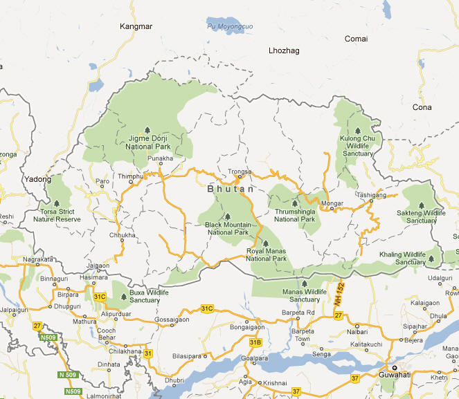
Bhutan Map