Where is Venezuela Located?
Where is Venezuela located on the map? Venezuela is an independent nation located in South America. Check out the following images to see location of Venezuela on maps.
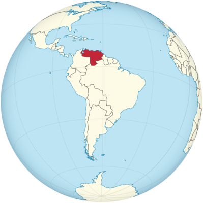
Venezuela Location in World Map
Venezuela is located in South America, in the northwest of the continent. It borders the Atlantic coast, which is a proud 2800 kilometers long. Most of it belongs to the Caribbean Sea. Venezuela has national borders with Colombia in the west and Guyana and Brazil in the east and south. The outline of the country is somewhat reminiscent of a triangle.
The equator runs just south of Venezuela. Venezuela can be divided into four major natural areas: the Andes, the Orinoco plain, the Maracaibo lowlands and the Guyana highlands.
Venezuela is located in the northwest of South America.
Islands
Numerous islands in the Caribbean Sea belong to Venezuela. This also includes Isla Margarita and its small neighboring islands Coche and Cubagua. The island of Tortuga is also part of Venezuela. It is only occasionally inhabited by fishermen. Close to the coast are the island states of Trinidad and Tobago as well as Aruba and Grenada, but also the islands of Bonaire and Curaçao, which belong to the Netherlands.
Guiana Esequiba
A large area that belongs to the state of Guiana is still claimed by Venezuela today. In 1899 it was awarded to Great Britain in an arbitration award, and in 1963 Guiana became independent. Venezuela does not recognize this to this day.
The map shows you the political structure of the country. The red striped area is claimed by Venezuela, but it belongs to Guyana. Click on the map, then you can also see the islands. Margarita Island is the one in purple.
Mountains
The Andes
In the west of the country, the Andes come in an arc from Colombia. The Andes mountain range stretches across the entire west coast of South America and ends here in Venezuela. The Andes can in turn be divided into individual mountain ranges. In the west of Venezuela rises the Mérida Cordillera, the continuation of the great Eastern Cordillera of the Andes. Here is also the highest mountain in the country, the Pico Bolívar. It is 4981 meters high. Like some of the other surrounding peaks, it is covered in snow all year round.
A large part of Venezuela’s population lives in the valleys of the Andes. Big cities like Valencia, Barquisimeto or Mérida are located here. After a depression, another mountain range follows on the coast, the Central Cordillera ( Cordillera Central or Cordillera Caribe ). This can in turn be divided into the northern coastal cordillera and the southern Serranía del Interior. Even further east, separated by the Unare Depression, the mountains continue into the eastern Cordillera ( Cordillera Oriental ).
The Orinoco Plain or Llanos
The Orinoco Plain stretches across Colombia and Venezuela. In the west the Andes border the plain, in the north the coast and in the south the Orinoco river. There is mainly grassland here. On the coast, the Orinoco forms a wide, swampy delta. The word Llano is Spanish and means level. After that, this landscape is also called the Llanos.
Maracaibo lowlands
In western Venezuela, between the Central Cordillera and the Merida Cordillera, lies the Maracaibo Lowland. In its center is Lake Maracaibo. It is actually an inland sea, as it is connected to the Gulf of Venezuela by a 75-kilometer strait. The city, also called Maracaibo, is located on the western bank of this strait. It is the second largest city in the country.
The area northeast of the lowlands is sometimes viewed as a separate landscape. It is called Coriano and is bordered to the north by the Gulf of Venezuela. You can see it on the natural space map in pink.
The Gulf of Venezuela, in turn, is bounded by the Guajira Peninsula (which largely belongs to Colombia) and the Paraguaná Peninsula. The landscape here is very dry and desert-like. The land bridge to Paraguaná with its large dunes belongs to the Médanos National Park.
Guiana Highlands (Guiana Shield)
The Guiana Mountains extend southeast of the Orinoco. More than half of the country is one of them. On the border with the state of Guyana lies the Gran Sabana, a plateau with flat valleys from which the tepuis protrude. These are large table mountains that were created by erosion. With their steep walls, they rise up to 1000 meters above the rainforest. Some tepuis have never been entered by a human. There are long cave systems in the tepuis and the highest waterfalls in the world tumble down from them. The highest, free falling waterfall in the world is also here, the Salto Àngel. It falls 978 meters!
Rivers and Lakes
Venezuela is crossed by more than a thousand rivers. The Orinoco is Venezuela’s longest river at 2,574 kilometers. It rises near the Brazilian border in the Guyana highlands and then flows in a wide arc towards the Atlantic. The Orinoco is the second longest river in South America after the Amazon. The Río Caroní and Río Apure are important tributaries of the Orinoco.
Location Information of Venezuela
Venezuela is a country located on the northern coast of South America, bordered by the Caribbean Sea to the north, Colombia to the west and southwest, Brazil to the south, and Guyana to the east. It has a diverse geography, which includes coastal plains, mountains, forests, and vast plains known as the Llanos. Venezuela is rich in natural resources, particularly oil, which has historically been a major economic driver.
Latitude and Longitude
Venezuela is located between Latitude 0°N to 13°N and Longitude 59°W to 73°W. Its geographical position gives the country a tropical climate with proximity to both the Caribbean Sea and the Andes Mountains. This diversity in geography contributes to the varied ecosystems found within the country.
Capital City and Major Cities
Capital City: Caracas
The capital city of Venezuela, Caracas, is located in the northern part of the country, nestled in a valley within the Venezuelan coastal mountains. Caracas is the largest city in Venezuela and serves as the political, cultural, and economic center of the country. It is situated at Latitude 10.4915° N and Longitude 66.8983° W.
Caracas is known for its stunning views of the surrounding mountains, particularly the Avila National Park, which offers a green respite from the city’s urban sprawl. Despite its economic and political importance, Caracas has faced challenges related to crime, infrastructure, and political instability in recent years.
Major Cities
- Maracaibo Maracaibo, located in the northwest of Venezuela, is the second-largest city and an important industrial and commercial hub. It is situated near the western shore of Lake Maracaibo, which is the largest lake in Latin America and a major oil-producing region. Maracaibo is located at Latitude 10.6191° N and Longitude 71.2069° W.
- Valencia Valencia, located in central Venezuela, is a major city in the Carabobo state and an industrial center, particularly known for its automotive manufacturing industry. The city is situated at Latitude 10.1590° N and Longitude 68.0030° W. Valencia is also close to Venezuela’s coastline and the country’s largest port, Puerto Cabello.
- Barquisimeto Located in western Venezuela, Barquisimeto is the capital of the Lara state and is known as the “City of Music” due to its vibrant cultural scene. Barquisimeto is situated at Latitude 10.0708° N and Longitude 69.3033° W and is an important center for commerce and agriculture in the region.
- Maracay Maracay, located in the central region of Venezuela, is the capital of the Aragua state and is often referred to as the “City of the Sun” due to its warm, sunny climate. It is an industrial hub, with a strong presence in agriculture, food processing, and textiles. Maracay is located at Latitude 10.2463° N and Longitude 67.5953° W.
- Puerto La Cruz Puerto La Cruz is a coastal city located in the Anzoátegui state in eastern Venezuela, known for its beaches and proximity to the Mochima National Park. This city, located at Latitude 10.1786° N and Longitude 64.4855° W, serves as an important port and tourist destination.
Time Zone
Venezuela operates on Venezuela Time (VET), which is UTC -4:00. The country does not observe daylight saving time, so the time remains the same year-round.
Climate
Venezuela has a predominantly tropical climate, but the country’s diverse geography results in a range of climate zones, from hot and humid coastal areas to cooler highland regions. The climate varies significantly depending on the altitude and proximity to the Caribbean Sea.
- Coastal Regions: The coastal areas, including Caracas, Maracaibo, and Puerto La Cruz, have a tropical climate with hot temperatures throughout the year, often ranging from 25°C to 32°C (77°F to 90°F). These areas experience a wet season from May to October, with heavy rainfall and humidity, and a dry season from November to April.
- Andean Highlands: The Andean mountain region, where cities like Mérida are located, has a more temperate climate due to its higher elevation. Temperatures in the highlands can range from 10°C to 20°C (50°F to 68°F), and the region experiences a cooler, more moderate climate year-round. The highlands also tend to be drier, with a dry season running from December to March.
- Llanos and Plains: The Llanos, Venezuela’s vast plains, experience a tropical savanna climate with distinct wet and dry seasons. The wet season runs from May to November, while the dry season lasts from December to April. Temperatures in the Llanos typically range from 22°C to 38°C (72°F to 100°F).
- Rainforests: The regions near Venezuela’s Amazon Basin, such as the southern part of the country, have a humid, equatorial climate, with year-round high temperatures and abundant rainfall.
Economic Status
Venezuela is a country rich in natural resources, especially oil, which has historically been the backbone of its economy. However, the nation has faced severe economic challenges over the past two decades due to political instability, mismanagement of resources, and falling oil prices. Hyperinflation, a shrinking GDP, and widespread poverty have been some of the consequences of these issues.
Key Sectors of the Economy:
- Oil and Gas Oil is by far the most significant sector in Venezuela’s economy. The country has some of the largest proven oil reserves in the world, particularly in the Orinoco Belt. Oil exports make up a significant portion of Venezuela’s GDP and government revenue. However, the oil sector has been severely affected by a lack of investment, aging infrastructure, and international sanctions, leading to a sharp decline in production in recent years.
- Agriculture Agriculture in Venezuela is important but has suffered due to the economic crisis and a lack of investment in rural areas. The country produces a variety of crops, including coffee, sugar, corn, and rice. Venezuela also has a rich fishing industry, with its Caribbean coastline providing a significant resource for seafood exports.
- Manufacturing Venezuela’s manufacturing sector has experienced a decline due to the lack of raw materials, energy shortages, and economic instability. Key industries that remain include food processing, textiles, and automotive manufacturing.
- Tourism Venezuela’s natural beauty, including its beaches, mountains, and rainforests, has the potential to support a thriving tourism industry. The country is home to the world’s highest uninterrupted waterfall, Angel Falls, and several national parks. However, tourism has been significantly affected by the country’s economic and political situation, with many tourists avoiding the country due to safety concerns.
- Services and Finance The services sector in Venezuela has contracted due to the ongoing economic crisis. The banking system faces significant challenges, including hyperinflation, currency devaluation, and a lack of international credit. The finance sector remains largely unstable.
Challenges:
Venezuela’s economy has been in freefall for years due to inflation, a collapsing oil sector, and widespread poverty. The government’s mismanagement, coupled with international sanctions and falling global oil prices, has left the country in a prolonged crisis. This has led to food and medicine shortages, high unemployment, and the mass emigration of Venezuelans to neighboring countries.
Tourist Attractions
Venezuela offers a wide variety of natural and cultural attractions. From stunning beaches to dramatic mountains and rainforests, there is much to see, though the current political and economic climate has limited international tourism.
1. Angel Falls
Angel Falls, located in Canaima National Park in the Gran Sabana region, is the world’s highest uninterrupted waterfall, plunging 979 meters (3,212 feet). It is one of Venezuela’s most famous tourist attractions and a UNESCO World Heritage site. The falls are accessible by boat, and visitors can enjoy scenic views of the surrounding rainforests.
2. Margarita Island
Margarita Island, off the northern coast of Venezuela, is known for its beautiful beaches, warm weather, and relaxed atmosphere. Popular with tourists from both Venezuela and abroad, the island offers opportunities for water sports, hiking, and exploring its colonial architecture.
3. Morrocoy National Park
Located along the central Venezuelan coast, Morrocoy National Park is a popular destination for beach lovers and divers. The park is home to stunning coral reefs, clear waters, and several picturesque islands.
4. Canaima National Park
This vast park in southeastern Venezuela is home to Angel Falls and offers numerous opportunities for eco-tourism. The park features exotic wildlife, stunning rivers, and spectacular tepuis (tabletop mountains). Visitors can explore the park by boat, hiking, and camping.
5. Los Roques Archipelago
Los Roques is a paradise for beach lovers, offering beautiful white-sand beaches, turquoise waters, and excellent diving and snorkeling conditions. The archipelago consists of over 300 islands and cays and is a UNESCO Biosphere Reserve.
Visa Requirements for U.S. Citizens
U.S. citizens need a tourist visa to visit Venezuela. The process can be cumbersome due to the current political climate, and U.S. citizens are advised to check with the Venezuelan embassy for the latest visa requirements. Some general guidelines include:
- Tourist Visa: U.S. citizens can apply for a tourist visa at the Venezuelan embassy. The visa typically allows a stay of up to 90 days.
- Visa on Arrival: It is possible to obtain a visa on arrival, but travelers should check current regulations as the political situation can affect visa issuance.
Distance to New York City and Los Angeles
- Distance from Caracas to New York City
The distance between Caracas and New York City is approximately 3,100 kilometers (1,926 miles). Flights typically take around 4.5 to 5 hours, depending on the route. - Distance from Caracas to Los Angeles
The distance between Caracas and Los Angeles is about 4,000 kilometers (2,485 miles). A flight usually takes about 7 to 8 hours, depending on the route and flight conditions.
Venezuela Facts
| Size | 912,050 km² |
| Residents | 28.8 million |
| Languages | Spanish (official language) and 31 regional languages |
| Capital | Caracas |
| Longest river | Orinoco (2,140 km) |
| Highest mountain | Pico Bolívar (4,981 m) |
| Currency | Bolívar |


