Where is Spain Located?
Where is Spain located on the map? Spain is an independent nation located in Southern Europe. Check out the following images to see location of Spain on maps.
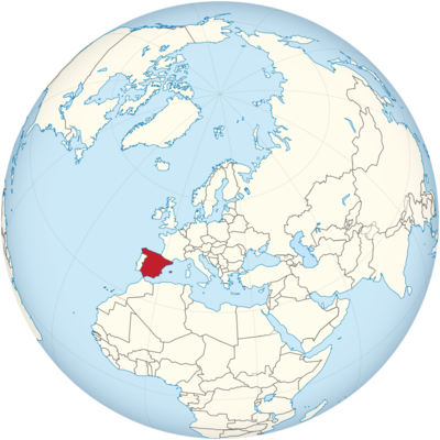
Spain Location in World Map
Spain is located in the southwest of Europe.
Location Information of Spain
Spain, a diverse and culturally rich country located in Southern Europe, occupies most of the Iberian Peninsula, sharing borders with Portugal, France, Andorra, and the Mediterranean Sea. Known for its history, art, cuisine, and landscapes, Spain is one of the world’s most visited countries.
Latitude and Longitude
Spain’s geographical coordinates are approximately 36° to 43° North latitude and 3° to 10° West longitude. This positions the country in Southwestern Europe, extending across a variety of landscapes, from mountainous regions to coastal plains.
Capital City and Major Cities
Capital City: Madrid
The capital city of Spain is Madrid, located in the center of the country. It is the largest city in Spain with a population of around 3.3 million in the city proper and over 6.5 million in the metropolitan area. Madrid is known for its rich cultural heritage, vibrant arts scene, and role as the political and economic heart of the country. Major landmarks include the Royal Palace, the Prado Museum, and the Puerta del Sol.
Coordinates: 40.4168° N, 3.7038° W
Madrid serves as a major hub for business, finance, and tourism, and is well-connected internationally, especially through Adolfo Suárez Madrid–Barajas Airport, one of the busiest airports in Europe.
Major Cities
- Barcelona: Located on the northeastern coast along the Mediterranean Sea, Barcelona is the second-largest city in Spain with a population of about 1.6 million. Known for its Modernist architecture, particularly the works of architect Antoni Gaudí, Barcelona is also a major economic and cultural hub. Key attractions include the Sagrada Familia, Park Güell, and Las Ramblas.Coordinates: 41.3784° N, 2.1925° E
- Valencia: Situated on the eastern coast, Valencia has a population of about 800,000. The city is known for its beautiful beaches, the futuristic City of Arts and Sciences, and its annual Las Fallas festival. Valencia also plays a crucial role in Spain’s agriculture industry, particularly for its oranges and paella.Coordinates: 39.4699° N, 0.3763° W
- Seville: Located in the southern region of Andalusia, Seville is known for its vibrant cultural traditions, including flamenco dancing, bullfighting, and its stunning architecture, like the Alcázar and Giralda Tower. Seville has a population of approximately 1.9 million and is a hub for tourism and arts.Coordinates: 37.3886° N, 5.9823° W
- Malaga: Situated on the southern coast in the Costa del Sol region, Malaga has a population of around 570,000. Known for its beautiful beaches, Mediterranean climate, and historical sites, such as the Alcazaba Fortress and Picasso Museum, Malaga is also a key entry point for travelers arriving by air or sea.Coordinates: 36.7213° N, 4.4216° W
- Bilbao: Located in northern Spain in the Basque Country, Bilbao is a major industrial and cultural center with a population of about 345,000. The city is famous for the Guggenheim Museum, which transformed its economy and international profile. Bilbao also enjoys a rich culinary scene, particularly for its pintxos.Coordinates: 43.2630° N, 2.9340° W
Time Zone
Spain predominantly follows Central European Time (CET, UTC+1) and observes Daylight Saving Time (DST), changing to Central European Summer Time (CEST, UTC+2) in the summer months.
- Time difference with New York City: Spain is 6 hours ahead of New York City during Standard Time and 5 hours ahead during Daylight Saving Time.
- Time difference with Los Angeles: Spain is 9 hours ahead of Los Angeles during Standard Time and 8 hours ahead during Daylight Saving Time.
Climate
Spain enjoys a variety of climates due to its geographical diversity. From Mediterranean climates along the coast to more continental and even alpine climates in the interior and northern regions, Spain offers diverse weather patterns.
Climate Zones
- Mediterranean Climate: The Mediterranean coast, including cities like Barcelona and Valencia, has a temperate climate with hot, dry summers and mild, wet winters. Average summer temperatures reach 30-35°C (86-95°F), while winter temperatures are typically 10-15°C (50-59°F).
- Continental Climate: Inland areas like Madrid and cities in the Castilian Plateau experience more extreme weather patterns, with hot summers (up to 40°C or 104°F) and cold winters (with temperatures dropping to -5°C or 23°F).
- Oceanic Climate: The northern coastal regions, including cities like Bilbao and Santander, experience a more temperate, oceanic climate, with cooler summers and mild, wet winters. Average temperatures in summer range from 20-25°C (68-77°F), and winters average 5-10°C (41-50°F).
- Subtropical and Alpine: The Canary Islands have a subtropical climate with mild, pleasant temperatures year-round, while the Pyrenees Mountains in the north offer alpine climate conditions with snow in the winter, ideal for skiing and snowboarding.
Economic Status
Spain is a developed economy and the fourth-largest economy in the Eurozone. The country is part of the European Union (EU) and the Eurozone, using the Euro (€) as its currency. Spain has a diverse economy based on industry, services, and agriculture.
Key Economic Sectors
- Tourism: Spain is one of the most popular tourist destinations in the world, attracting millions of visitors annually to its beaches, historical cities, and cultural landmarks. Tourism contributes significantly to Spain’s GDP, supporting industries such as hospitality, transport, and entertainment.
- Agriculture: Spain is a major agricultural producer in Europe, particularly known for its olive oil, wine, and citrus fruits. The country is one of the world’s largest exporters of olive oil, and La Rioja is a world-renowned wine region.
- Manufacturing and Industry: Spain’s industrial sector includes automobile manufacturing, textiles, and construction. Spain is home to several large multinational companies in the automotive and energy sectors, including Seat, Iberdrola, and Repsol.
- Services: The services sector, including finance, telecommunications, and technology, is another pillar of the Spanish economy. Cities like Madrid and Barcelona are key financial hubs in Southern Europe.
Economic Challenges
Spain has faced significant challenges, particularly during the 2008 global financial crisis and the subsequent Eurozone debt crisis. Unemployment, particularly among young people, remains high, although it has been steadily declining in recent years. Additionally, the Catalonia independence movement has created political instability in the region.
Tourist Attractions
Spain is a country filled with iconic landmarks, diverse landscapes, and a rich cultural heritage that attracts millions of tourists each year.
1. La Sagrada Familia (Barcelona)
Designed by architect Antoni Gaudí, La Sagrada Familia is an iconic basilica that has been under construction since 1882. It is a UNESCO World Heritage site and one of Spain’s most famous landmarks.
Coordinates: 41.4036° N, 2.1744° E
2. The Alhambra (Granada)
The Alhambra is a stunning example of Islamic architecture located in Granada, Andalusia. This former palace and fortress complex is famous for its intricate tile work, gardens, and panoramic views of the city.
Coordinates: 37.7775° N, 3.3583° W
3. The Prado Museum (Madrid)
The Prado Museum in Madrid is one of the most renowned art museums in the world, home to works by artists like Velázquez, Goya, and El Greco. The museum is located in the Paseo del Prado and is a must-see for art lovers.
Coordinates: 40.4138° N, 3.6922° W
4. Park Güell (Barcelona)
Another of Gaudí’s masterpieces, Park Güell is a public park in Barcelona featuring colorful mosaics, whimsical sculptures, and stunning views of the city. It is a UNESCO World Heritage site and one of the most visited parks in Spain.
Coordinates: 41.4145° N, 2.1527° E
5. Ibiza and the Balearic Islands
The Balearic Islands, including Ibiza, Mallorca, and Menorca, are popular destinations for their beautiful beaches, nightlife, and historic sites. Ibiza is particularly famous for its vibrant nightlife and electronic music scene.
Visa Requirements for U.S. Citizens
U.S. citizens traveling to Spain for tourism or business purposes for up to 90 days do not require a visa. Spain is part of the Schengen Area, and U.S. citizens can travel to other countries within the Schengen Zone under the same conditions.
Requirements for Entry:
- Valid passport (must be valid for at least 3 months beyond the intended date of departure)
- Return or onward travel ticket
- Proof of sufficient funds for the duration of the stay
For stays longer than 90 days or for other purposes such as work, a long-stay visa may be required.
Distance to New York City and Los Angeles
- Distance from Madrid to New York City: The approximate flight distance is 5,760 km (3,577 miles), with flight times ranging from 7-8 hours.
- Distance from Madrid to Los Angeles: The distance from Madrid to Los Angeles is about 9,000 km (5,592 miles), with flight durations typically between 11-12 hours.
Spain Facts
| Size | 504,645 km² |
| Residents | 46.72 million |
| Languages | Spanish, regionally also Catalan, Galician |
| Capital | Madrid |
| Longest river | Ebro (910 km) |
| Highest mountain | Pico del Teide on Tenerife (3,718 m) |
| Currency | Euro |


