Nigeria Facts
Nigeria, State of West Africa, Bay of Guinea; 924,000 km², 195.9 million residents (2019).Nigeria borders in the west to Benin, in the north to Niger, in the northeast to Chad and in the east and southeast to Cameroon and has the south coast to the Atlantic. The capital since 1991 is Abuja (1.4 million residents, 2010).

Country facts
- Federal Republic of Nigeria / Federal Republic of Nigeria
- Country abbreviation: NG
- Area: 924 000 km²
- Population (2019): 195.9 million residents
- Capital: Abuja
- Main languages: English, Hausa, Yoruba, Igbo
- State: Republic
- Head of State and Head of Government: Muhammadu Buhari (President)
- Per capita GDP (2018): USD 2,028
- GNI per capita (2018): US $ 1 960
- Currency unit: 1 naira = 100 kobo
- Currency code: NGN
- Country number (telephony): 234
- Internet Domain Name: ng
- Time difference compared to Sweden: 0
- National Day: October 1 (Independence Day, 1960)
Nature
- Land use: forest (10%), agricultural land (34%), other (56%)
- Highest mountain: Chappal Waddi (2,419 m above sea level)
- Longest river: Niger (4,160 km)
Population
- Population density (2019): 212 residents per km²
- Natural population growth (2019): 2.6%; birth number 38 ‰, death number 12 ‰
- Age structure (2019): 0-14 years (44%), 15-64 (53%), 65- (3%)
- Average life expectancy (2019): men 53 years, women 55 years
- Infant mortality (2019): 67 per 1,000 live births
- Population forecast 2050: 401 million residents
- HDI (2017): 0.532 (place 157 of 189)
- Urbanization rate (2019): 50%
- Most populous cities (2010): Lagos (10 million residents), Ibadan (5.2 million), Benin (2.4 million)
Business
- Industry’s contribution to GDP (2017): agriculture (21%), industry (22%), service (57%)
- Exports of goods (2017): US $ 1,146 million
- Main export products: oil, natural gas, cocoa
- Main exporting countries: India, USA, Spain
- Imports of goods (2017): US $ 32,670 million
- Main import products: machinery, chemicals, means of transport
- Main importing countries: China, Belgium, USA
- Railway network (2014): 3,800 km
Geography of Nigeria
Location
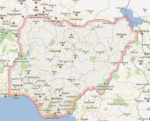
Nigeria is a country located in West Africa. It is bordered by Benin to the west, Chad and Cameroon to the east, and Niger to the north. To the south, it has a coastline along the Gulf of Guinea, which is part of the larger Atlantic Ocean. Nigeria’s strategic position along the coast gives it a significant role in trade and commerce, especially in terms of exports like oil. With its vast size, Nigeria is the most populous country in Africa and the seventh most populous in the world.
Topography
Nigeria has a varied topography that includes plains, plateaus, mountains, and valleys. The southern part of the country is characterized by a coastline, wetlands, and dense tropical forests. In contrast, the northern part is dominated by savannas and semi-arid regions, leading up to the Sahara Desert. Nigeria’s central region is marked by mountains and plateaus, including the Jos Plateau, which is known for its cooler climate compared to the rest of the country. The country’s highest point is Mount Chappal Waddi in the Taraba State, standing at 2,419 meters (7,936 feet) above sea level.
Rivers and Water Bodies
Nigeria is endowed with several significant rivers, including the Niger and Benue Rivers, which are the most prominent and contribute significantly to agriculture, transportation, and fishing. These rivers also divide the country into different regions and are vital sources of water for both rural and urban populations. The Niger River is the longest river in Nigeria, flowing from the northwest to the southeast, where it empties into the Gulf of Guinea.
Natural Resources
Nigeria is rich in natural resources, particularly petroleum, which is the backbone of its economy. The country also has substantial reserves of natural gas, tin, limestone, coal, and agricultural land. The country’s mineral wealth, especially its oil fields in the Niger Delta, makes it an important player in the global energy market.
Climate of Nigeria
Tropical Climate
Nigeria experiences a tropical climate, with distinct wet and dry seasons, which vary depending on the region. The southern part of the country, including cities like Lagos and Port Harcourt, experiences high humidity and heavy rainfall throughout the year. This region is characterized by a humid tropical climate, with annual rainfall ranging from 1,500 to 4,000 millimeters. The central and northern parts of Nigeria experience a more arid climate, with the savannah regions getting more seasonal rainfall, while the northernmost part near the Sahara Desert has a hot and dry climate.
Wet and Dry Seasons
Nigeria has a distinct wet season from April to October, characterized by heavy rainfall, especially in the southern regions. The dry season, known as the Harmattan, occurs from November to March. During this period, the country experiences dry winds from the Sahara Desert, resulting in cooler temperatures and lower humidity levels. The Harmattan also brings dust, which reduces visibility and affects air quality.
Variations Across Regions
Nigeria’s climate varies significantly across its regions. The coastal regions of the south experience tropical rainforests, while the central region, like the Jos Plateau, has a cooler climate. In the north, the climate transitions into a semi-arid zone, with temperatures often exceeding 40°C during the hottest months. The variation in climate also influences the types of crops grown and the types of animals that can be raised in different parts of the country.
People of Nigeria
Population
Nigeria is the most populous country in Africa, with an estimated population of over 223 million people. The country’s population is diverse, consisting of over 500 different ethnic groups, each with its own language, customs, and traditions. The large population, combined with rapid urbanization, makes Nigeria one of the most dynamic and youthful countries in the world. It also has a large diaspora, with many Nigerians living abroad in countries such as the United States, the United Kingdom, and South Africa.
Ethnic Groups
Nigeria’s ethnic composition is highly diverse. The three largest ethnic groups are the Hausa-Fulani, Yoruba, and Igbo. The Hausa-Fulani are primarily found in the northern region, while the Yoruba are predominantly in the southwestern part, and the Igbo live mainly in the southeastern part of the country. Other notable ethnic groups include the Kanuri, Tiv, Edo, Ijaw, and Ibibio. Each group has its own distinct language and cultural practices, contributing to the rich tapestry of Nigeria’s society.
Languages
Nigeria is a multilingual country with over 500 languages spoken across its regions. The official language is English, a legacy of British colonial rule, which serves as a unifying factor in the country. However, indigenous languages like Hausa, Yoruba, Igbo, and Pidgin English are widely spoken. Hausa is the dominant language in the north, Yoruba in the southwest, and Igbo in the southeast. While the diversity of languages is a source of cultural richness, it has also led to challenges in communication and national unity.
Religion
Nigeria is religiously diverse, with Islam and Christianity being the two dominant religions. Islam is primarily practiced in the northern part of the country, while Christianity is prevalent in the south and southeastern regions. In addition to these major religions, traditional African religions continue to be practiced in various forms, especially in the middle-belt and southern regions. Religious identity is an important aspect of Nigerian society, and interfaith relations can be complex, particularly in the context of Nigeria’s historical religious and ethnic divisions.
Economy of Nigeria
Oil and Petroleum
The backbone of Nigeria’s economy is its oil and gas industry, which accounts for over 90% of export revenues and a significant portion of the country’s GDP. Nigeria is one of the largest oil producers in Africa and ranks among the top 20 oil producers globally. The Niger Delta region, located in the southern part of the country, is the main oil-producing area, and its oil reserves contribute heavily to the country’s income. Despite this wealth, Nigeria struggles with the challenges of oil dependency, such as fluctuating oil prices, corruption, and environmental degradation.
Agriculture
Agriculture has historically been a vital part of Nigeria’s economy, and the country has the potential to become a major agricultural producer. The main crops grown include cassava, yams, maize, rice, and sorghum. Nigeria also has a strong livestock sector, particularly in poultry and cattle farming. While the country still relies on imports for many of its food products, agriculture remains a critical part of the economy, providing employment for a large portion of the population, particularly in rural areas.
Services and Industry
Nigeria’s services sector, including banking, telecommunications, and tourism, has been growing rapidly in recent years. The country is home to a burgeoning tech industry, particularly in cities like Lagos, which is often referred to as the tech hub of Africa. The country’s industrial base is diverse, including industries like cement production, textiles, food processing, and pharmaceuticals. However, Nigeria’s industrial growth is often hindered by inadequate infrastructure, poor electricity supply, and a lack of access to credit for small businesses.
Challenges and Economic Development
Nigeria faces significant economic challenges, including poverty, unemployment, and inequality. Despite its vast natural resources, the country has struggled with economic diversification, relying too heavily on oil revenues. Corruption, political instability, and insecurity have also impeded economic growth and development. However, there have been efforts to improve infrastructure, create job opportunities, and promote sectors like agriculture and manufacturing to reduce Nigeria’s reliance on oil and foster sustainable economic growth.
Government of Nigeria
Political Structure
Nigeria is a federal republic with a presidential system of government. The country operates under a constitution that divides power between the central government and 36 states, as well as the Federal Capital Territory (FCT) in Abuja, the capital city. The president serves as both the head of state and head of government, and is elected every four years through a popular vote. Nigeria’s political system is based on democratic principles, although the country has experienced periods of military rule in its history.
The Presidency
The president is the chief executive of the country, responsible for overseeing the national government, the military, and foreign relations. The president is elected by a direct vote, with a requirement to secure a majority in both the national vote and a plurality in at least two-thirds of Nigeria’s 36 states. The president’s powers include issuing executive orders, appointing ministers, and serving as the commander-in-chief of the armed forces. The current political landscape is dominated by two main parties: the All Progressives Congress (APC) and the People’s Democratic Party (PDP).
Legislature
Nigeria’s National Assembly consists of a bicameral legislature, with the Senate and the House of Representatives. The Senate, made up of 109 members, is responsible for passing laws and approving presidential appointments. The House of Representatives has 360 members and is tasked with legislating on matters that affect the country. Both chambers have the power to impeach the president, but this requires a two-thirds majority vote.
Judiciary
The judiciary in Nigeria is independent, with the Supreme Court serving as the highest court in the country. The court system is based on common law principles, but Sharia law is also used in the northern states, where Islam is the predominant religion. The judicial branch is tasked with interpreting the constitution, ensuring justice, and protecting human rights. However, Nigeria’s judicial system has faced challenges related to corruption, inefficiency, and limited access to justice for ordinary citizens.
Culture of Nigeria
Traditions and Customs
Nigeria’s culture is a blend of indigenous, Islamic, and Western influences. Traditional music, dance, and art are integral to Nigerian society, with each ethnic group having its own unique customs. Festivals and ceremonies, such as weddings, harvest festivals, and religious celebrations, are important social events. Nigerian music, including genres like Afrobeat, highlife, and traditional drumming, is celebrated both within the country and globally. The arts, such as sculpture and beadwork, also hold cultural significance, especially among ethnic groups like the Yoruba and the Benin people.
Food and Cuisine
Nigerian cuisine is varied and reflects the country’s diverse ethnic groups. Some common dishes include jollof rice, pounded yam, efo riro (spinach stew), and suya (spicy grilled meat). Different regions of Nigeria have their own signature dishes based on locally available ingredients, such as seafood in the coastal regions and millet-based dishes in the north. Nigerian food is known for its rich flavors and the use of spices, peppers, and oils.
Literature and Arts
Nigeria has a rich literary tradition, with authors such as Chinua Achebe, Wole Soyinka, and Chimamanda Ngozi Adichie achieving international acclaim. Nigerian literature often addresses themes such as colonialism, independence, identity, and social issues. Art in Nigeria is diverse, ranging from traditional crafts to contemporary art forms. Nigerian cinema, known as Nollywood, is one of the largest film industries in the world and plays a significant role in shaping Nigerian culture and global perceptions of the country.
History of Nigeria
Early History and Kingdoms
Nigeria has a long history, with some of the earliest known civilizations in Africa. Ancient kingdoms such as the Nok, Benin, and Oyo thrived in Nigeria long before the arrival of European colonizers. The Nok civilization, which existed from around 1000 BCE to 300 CE, is particularly known for its terracotta sculptures. These early civilizations were organized, with rich traditions in art, trade, and governance.
Colonial Era
In the late 19th century, Nigeria became a British colony after a series of treaties and military confrontations. The British colonial administration consolidated various ethnic groups into one entity, often with little regard for the existing political structures. This led to tensions between different ethnic groups, a situation that has had lasting implications for Nigeria’s post-colonial history.
Independence and Modern History
Nigeria gained independence from Britain on October 1, 1960, becoming a republic in 1963. Since independence, Nigeria has experienced a turbulent political history, with several military coups and a brutal civil war (1967–1970) between the government and the secessionist state of Biafra. After a series of military regimes, Nigeria returned to civilian rule in 1999, establishing a multi-party democracy. Despite challenges such as corruption, security issues, and economic inequality, Nigeria remains a dominant force in Africa and continues to play a key role in global politics.
Nigeria Map