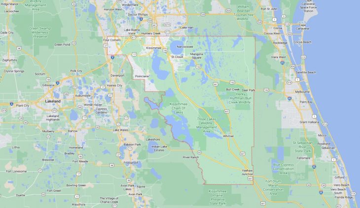
Cities and Towns in Osceola County, Florida

Founded in 1887, Osceola County is one of 67 counties in the state of Florida. Historically, Osceola County was formed from Brevard and Orange. The city of Kissimmee is the county seat. With FIPS code of 97, Osceola County has a population of 403,282 and area of 1,322 square miles (3,424 km²).

List of all cities in Osceola County, FL alphabetically

City/Town Postal Code Area Code
Buena Ventura Lakes, FL 34743 407/321/689
Celebration, FL 34747 407/321/689
Good Samaritan, FL 34746 407/321/689
Harmony, FL 34773 407/321/689
Intercession City, FL 33848 407/321/689
Kenansville, FL 34739 407/321/689
Kissimmee, FL 34741 407/321/689
34742 407/321/689
34743 407/321/689
34744 407/321/689
34745 407/321/689
34746 407/321/689
34747 407/321/689
34758 407/321/689
Magnolia Square, FL 34771 407/321/689
Poinciana, FL 34758 407/321/689
Reunion, FL 34747 407/321/689
Saint Cloud, FL 34769 407/321/689
34770 407/321/689
34771 407/321/689
34772 407/321/689
34773 407/321/689

Major Cities and Towns in Osceola County, Florida

Kissimmee

Area, Population, and Geographic Coordinates

  • Area: 21.5 square miles
  • Population: Approximately 79,226 (as of 2020)
  • Zip Codes: 34741, 34742, 34743, 34744, 34745, 34746, 34747
  • Latitude: 28.2919° N
  • Longitude: 81.4076° W

Location and History

Kissimmee is the county seat of Osceola County, located in central Florida near Orlando. The city was originally established as a small trading post along the Kissimmee River in the mid-19th century and grew significantly after the arrival of the railroad in the late 1800s. The development of the cattle and citrus industries played a crucial role in the city’s early economy. Kissimmee’s proximity to Walt Disney World and other major theme parks in the Orlando area has transformed it into a major tourist destination, attracting millions of visitors each year. The city’s historic downtown area features charming shops, restaurants, and a scenic waterfront park, offering a glimpse into its past while embracing its role as a gateway to Central Florida’s attractions.

Major Schools and Landmarks

Kissimmee is served by the School District of Osceola County, with notable schools including Osceola High School and Kissimmee Middle School. Major landmarks in Kissimmee include the historic Kissimmee Lakefront Park, which offers a marina, walking trails, and beautiful views of Lake Tohopekaliga. The nearby Osceola County Historical Society’s Pioneer Village showcases a collection of restored 19th-century buildings, providing a window into the region’s early history. The city’s annual events, such as the Kissimmee Valley Rib Rodeo, reflect the community’s rich cultural heritage and family-friendly atmosphere. Kissimmee’s combination of historical significance, educational institutions, and proximity to world-renowned attractions makes it the central city in Osceola County.

St. Cloud

Area, Population, and Geographic Coordinates

  • Area: 19.9 square miles
  • Population: Approximately 54,579 (as of 2020)
  • Zip Codes: 34769, 34770, 34771, 34772, 34773
  • Latitude: 28.2489° N
  • Longitude: 81.2812° W

Location and History

St. Cloud is a city located just east of Kissimmee, in Osceola County. The city was founded in 1909 as a retirement community for Civil War veterans and was originally known as the “Soldier City.” St. Cloud’s layout and architecture reflect its early history, with streets named after states and historic homes dotting the landscape. Over the years, the city has evolved into a growing suburban community, known for its peaceful neighborhoods, recreational facilities, and strong sense of community. St. Cloud’s location along the southern shore of East Lake Tohopekaliga provides residents and visitors with access to water-based activities and stunning lakeside views.

Major Schools and Landmarks

St. Cloud is served by the School District of Osceola County, with notable schools including St. Cloud High School and Neptune Middle School. Major landmarks in St. Cloud include the St. Cloud Lakefront Park, which offers a beach area, marina, and playgrounds, making it a popular spot for families and outdoor enthusiasts. The city’s historic downtown district features a variety of shops, restaurants, and cultural attractions, including the St. Cloud Heritage Museum, which preserves the history of the community and its early settlers. The city’s annual events, such as the St. Cloud Food Truck Bazaar and the St. Cloud Craft Beer and Wine Walk, celebrate the local culture and community spirit. St. Cloud’s combination of historical significance, educational institutions, and suburban charm makes it an important city in Osceola County.

Poinciana

Area, Population, and Geographic Coordinates

  • Area: 35.3 square miles
  • Population: Approximately 69,309 (as of 2020, including portions in Polk County)
  • Zip Codes: 34758, 34759
  • Latitude: 28.1406° N
  • Longitude: 81.4584° W

Location and History

Poinciana is a large unincorporated community located in the southern part of Osceola County, extending into Polk County. The community was originally developed in the 1970s as a master-planned community by the General Development Corporation. Poinciana was designed to offer affordable housing in a suburban environment, with a focus on family-friendly amenities and a strong sense of community. Over the years, Poinciana has grown rapidly, attracting a diverse population due to its proximity to Orlando and the attractions of Central Florida. The community’s name is derived from the royal poinciana tree, known for its vibrant red flowers, which are a common sight in the area.

Major Schools and Landmarks

Poinciana is served by the School District of Osceola County, with notable schools including Poinciana High School and Bellalago Academy. Major landmarks in Poinciana include the Mary Jane Arrington Gym and Aquatic Center, offering a variety of recreational facilities for residents, and the Poinciana Community Park, which features sports fields, playgrounds, and walking trails. The nearby Lake Marion provides opportunities for boating, fishing, and enjoying the natural beauty of the area. The community’s annual events, such as the PoincianaFest, celebrate the local culture with live music, food, and family-friendly activities. Poinciana’s combination of planned development, educational institutions, and community-focused amenities makes it an important part of Osceola County.

Celebration

Area, Population, and Geographic Coordinates

  • Area: 10.7 square miles
  • Population: Approximately 9,923 (as of 2020)
  • Zip Codes: 34747
  • Latitude: 28.3170° N
  • Longitude: 81.5409° W

Location and History

Celebration is a master-planned community located in the southwestern part of Osceola County, near Walt Disney World Resort. The community was developed by The Walt Disney Company in the 1990s as an idealized version of small-town America, with a focus on architectural beauty, walkability, and a strong sense of community. Celebration’s design reflects the principles of New Urbanism, with a mix of residential, commercial, and civic buildings arranged in a pedestrian-friendly layout. The community’s location near major theme parks and its unique design have made it a popular place to live for Disney enthusiasts and those seeking a close-knit community.

Major Schools and Landmarks

Celebration is served by the School District of Osceola County, with Celebration School being the primary educational institution in the area. Major landmarks in Celebration include Market Street, the community’s downtown area, which features shops, restaurants, and cultural events throughout the year. The Celebration Golf Club, designed by Robert Trent Jones Sr. and Jr., is a popular destination for golf enthusiasts, offering a challenging course set against the backdrop of Celebration’s scenic landscape. The community’s annual events, such as the Celebration Art and Wine Stroll and the Celebration Exotic Car Festival, draw visitors from across the region. Celebration’s combination of carefully planned development, educational institutions, and unique charm makes it a notable community in Osceola County.

Buenaventura Lakes

Area, Population, and Geographic Coordinates

  • Area: 6.1 square miles
  • Population: Approximately 26,079 (as of 2020)
  • Zip Codes: 34743
  • Latitude: 28.3400° N
  • Longitude: 81.3536° W

Location and History

Buenaventura Lakes, often referred to as BVL, is a large residential community located in the northeastern part of Osceola County, near the city of Kissimmee. The community was developed in the 1980s as an affordable suburban neighborhood for families and retirees. Buenaventura Lakes was designed with a focus on residential living, offering a variety of housing options, including single-family homes and apartments. The community’s location near major highways, including Florida’s Turnpike and the Osceola Parkway, provides easy access to Orlando, Kissimmee, and other parts of Central Florida, making it a convenient place to live for commuters and families.

Major Schools and Landmarks

Buenaventura Lakes is served by the School District of Osceola County, with notable schools including Boggy Creek Elementary School and Parkway Middle School. Major landmarks in Buenaventura Lakes include the Buenaventura Lakes Community Park, which offers sports fields, playgrounds, and a community center, making it a popular spot for residents to gather and participate in recreational activities. The nearby Osceola County Stadium, located within the larger Osceola Heritage Park complex, is a key venue for sports events, concerts, and community festivals. The community’s annual events, such as the BVL Easter Egg Hunt and the BVL Christmas Parade, reflect the strong sense of community and family-oriented culture in the area. Buenaventura Lakes’ combination of residential development, educational institutions, and community amenities makes it an important part of Osceola County.

Map of Cities in Osceola County, FL

Map of Cities in Osceola County, FL