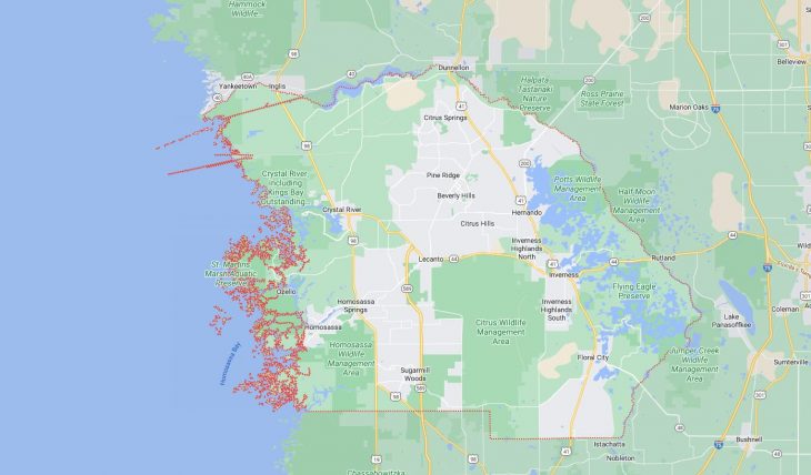
Cities and Towns in Citrus County, Florida

Founded in 1887, Citrus County is one of 67 counties in the state of Florida. Historically, Citrus County was formed from Hernando. The city of Inverness is the county seat. With FIPS code of 17, Citrus County has a population of 158,083 and area of 584 square miles (1,513 km²).

List of all cities in Citrus County, FL alphabetically

City/Town Postal Code Area Code
Beverly Hills, FL 34464 352
34465 352
Citrus Hills, FL 34442 352
Citrus Springs, FL 34433 352
34434 352
Crystal River, FL 34423 352
34428 352
34429 352
Dunnellon, FL 34433 352
Dunnellon, FL 34434 352
Floral City, FL 34436 352
Hernando, FL 34442 352
Holder, FL 34445 352
Homosassa, FL 34446 352
34448 352
34487 352
Homosassa Springs, FL 34447 352
Inverness, FL 34450 352
34451 352
34452 352
34453 352
Lecanto, FL 34460 352
34461 352
Pine Ridge, FL 34465 352

Major Cities and Towns in Citrus County, Florida

Inverness

Area, Population, Zip Codes, Latitude and Longitude

  • Area: 7.7 square miles
  • Population: Approximately 7,500 (as of the 2020 census)
  • Zip Codes: 34450, 34452, 34453
  • Latitude and Longitude: 28.8354° N, 82.3409° W

Location and History

Inverness is the county seat of Citrus County, located in the central part of the county along the shores of Lake Tsala Apopka. The city was originally named “Tompkinsville” after its founder, Alf Tompkins, but was renamed Inverness in 1891 to attract Scottish settlers, as the area’s rolling hills and lakes were reminiscent of the Scottish Highlands. The city has a rich history, particularly in the context of Florida’s development as a state, with its downtown area featuring several historic buildings from the late 19th and early 20th centuries. Inverness has long been a center for government and commerce within the region, offering a blend of historic charm and modern amenities.

Major Schools and Landmarks

Inverness is home to Citrus High School, Inverness Middle School, and Pleasant Grove Elementary School, serving the educational needs of the local population. Major landmarks in the city include the historic Citrus County Courthouse, which now functions as a museum, and Liberty Park, which offers scenic views of Lake Henderson and hosts various community events throughout the year. The Withlacoochee State Trail, one of the longest paved rail-trails in Florida, passes through Inverness and is a popular spot for cycling and walking. The city’s combination of historical significance, natural beauty, and community spirit makes it a central part of Citrus County.

Crystal River

Area, Population, Zip Codes, Latitude and Longitude

  • Area: 6.8 square miles
  • Population: Approximately 3,100 (as of the 2020 census)
  • Zip Codes: 34428, 34429
  • Latitude and Longitude: 28.9025° N, 82.5926° W

Location and History

Crystal River is a coastal city located on the Gulf of Mexico in the western part of Citrus County. The city is named after the Crystal River, which flows from springs that are among the clearest and most pristine in Florida. Crystal River has a rich history that dates back thousands of years, with the nearby Crystal River Archaeological State Park preserving ancient Native American mounds and artifacts. The city was established in the late 19th century and grew as a hub for phosphate mining and commercial fishing. Today, Crystal River is known as the “Home of the Manatee” due to the large population of West Indian manatees that inhabit its warm spring waters, particularly in the winter months.

Major Schools and Landmarks

Crystal River is served by schools such as Crystal River High School, Crystal River Middle School, and Crystal River Primary School. The city is famous for the Crystal River National Wildlife Refuge, which protects the manatees and their habitat. Other major landmarks include the Three Sisters Springs, a popular spot for kayaking, snorkeling, and viewing manatees, and the Crystal River Archaeological State Park, which offers insights into the area’s ancient history. The city’s natural beauty and rich history make it a popular destination for both residents and tourists, contributing significantly to Citrus County’s identity.

Homosassa

Area, Population, Zip Codes, Latitude and Longitude

  • Area: 8.4 square miles
  • Population: Approximately 2,000 (as of the 2020 census)
  • Zip Codes: 34446, 34448
  • Latitude and Longitude: 28.7811° N, 82.6137° W

Location and History

Homosassa is a small community located in the southwestern part of Citrus County, along the Homosassa River. The area is known for its rich natural resources and has been inhabited for thousands of years, with Native American tribes using the river for fishing and transportation. The name “Homosassa” comes from a Seminole word meaning “river of fishes.” In the late 19th century, Homosassa became a center for the production of sugar, with the Yulee Sugar Mill being one of the most significant operations in the region. Today, the remains of the sugar mill are preserved as part of the Yulee Sugar Mill Ruins Historic State Park. Homosassa is now known for its natural beauty and serves as a gateway to outdoor activities and wildlife viewing.

Major Schools and Landmarks

Homosassa is served by Homosassa Elementary School and is in close proximity to schools in the nearby town of Crystal River. The area’s major landmarks include the Homosassa Springs Wildlife State Park, which is famous for its manatees, as well as other native Florida wildlife. The Yulee Sugar Mill Ruins Historic State Park offers a glimpse into Florida’s industrial past, with the well-preserved ruins of a 19th-century sugar plantation. The Homosassa River is also a popular destination for boating, fishing, and scalloping, attracting visitors from across the state. Homosassa’s combination of historical significance and natural beauty makes it a cherished community in Citrus County.

Lecanto

Area, Population, Zip Codes, Latitude and Longitude

  • Area: 26.3 square miles
  • Population: Approximately 6,000 (as of the 2020 census)
  • Zip Codes: 34460, 34461
  • Latitude and Longitude: 28.8516° N, 82.4873° W

Location and History

Lecanto is a central community in Citrus County, located inland, and known for its rural charm and natural surroundings. The area was originally settled in the late 19th century and has remained primarily residential and agricultural. Lecanto’s name is derived from the Seminole language, meaning “red place,” possibly referring to the region’s rich, fertile soil. Over the years, Lecanto has developed into a growing community with a mix of residential areas, schools, and commercial developments, while still retaining much of its natural beauty and open spaces. The community is a gateway to several state forests and wildlife management areas, making it a popular spot for outdoor enthusiasts.

Major Schools and Landmarks

Lecanto is home to several educational institutions, including Lecanto High School, Lecanto Middle School, and Lecanto Primary School. The area is also known for the Withlacoochee State Forest, which provides extensive opportunities for hiking, horseback riding, and camping. The Citrus Hills Golf and Country Club, located near Lecanto, is a prominent recreational destination, offering world-class golf courses and amenities. Another key landmark is the College of Central Florida’s Citrus Campus, which provides higher education opportunities to the residents of Citrus County. Lecanto’s combination of educational resources, recreational facilities, and natural beauty make it an essential part of Citrus County’s community fabric.

Beverly Hills

Area, Population, Zip Codes, Latitude and Longitude

  • Area: 3.01 square miles
  • Population: Approximately 8,500 (as of the 2020 census)
  • Zip Codes: 34465
  • Latitude and Longitude: 28.9150° N, 82.4587° W

Location and History

Beverly Hills is a census-designated place located in the central part of Citrus County. It was developed in the early 1960s as a retirement community, with a focus on providing affordable housing for retirees from the northern United States. The community was designed with a suburban layout, featuring single-story homes and convenient access to amenities. Over the years, Beverly Hills has grown into a vibrant residential area that continues to attract retirees, as well as younger families seeking a quiet, community-oriented lifestyle. The community’s growth has been supported by its proximity to larger towns and the availability of services and recreational facilities.

Major Schools and Landmarks

Beverly Hills is served by schools such as Forest Ridge Elementary School and Lecanto High School, which are part of the larger Citrus County School District. The community features several parks and recreational areas, including the Beverly Hills Community Park, which offers facilities for tennis, basketball, and other outdoor activities. The nearby Twisted Oaks Golf Club is a popular destination for local golfers, providing a challenging course in a scenic setting. Beverly Hills’ location also offers easy access to the Withlacoochee State Forest and the Gulf Coast, making it a convenient base for exploring the natural beauty of Citrus County. The community’s blend of affordability, amenities, and proximity to nature makes it an attractive place to live in Citrus County.

Map of Cities in Citrus County, FL

Map of Cities in Citrus County, FL