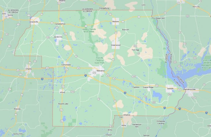
Cities and Towns in Jackson County, Florida
Founded in 1822, Jackson County is one of 67 counties in the state of Florida. Historically, Jackson County was formed from Escambia. The city of Marianna is the county seat. With FIPS code of 63, Jackson County has a population of 47,694 and area of 916 square miles (2,372 km²).
List of all cities in Jackson County, FL alphabetically
City/Town | Postal Code | Area Code |
Alford, FL | 32420 | 850 |
Bascom, FL | 32423 | 850 |
Campbellton, FL | 32426 | 850 |
Cottondale, FL | 32431 | 850 |
Cypress, FL | 32432 | 850 |
Graceville, FL | 32440 | 850 |
Grand Ridge, FL | 32442 | 850 |
Greenwood, FL | 32443 | 850 |
Jacob, FL | 32431 | 850 |
Malone, FL | 32445 | 850 |
Marianna, FL | 32446 | 850 |
32447 | 850 | |
32448 | 850 | |
Sneads, FL | 32460 | 850 |
Major Cities and Towns in Jackson County, Florida
Marianna
Area, Population, and Geographic Coordinates
- Area: 16.0 square miles
- Population: Approximately 7,091 (as of 2020)
- Zip Codes: 32446, 32447
- Latitude: 30.7744° N
- Longitude: 85.2362° W
Location and History
Marianna is the county seat and largest city in Jackson County, located in the Florida Panhandle along the Chipola River. The city was founded in 1827 and named after the wife of the original town settler, Robert Beveridge. Marianna quickly became an important center for commerce and agriculture in the region, with cotton plantations being the primary economic driver during the 19th century. The city played a significant role during the Civil War, particularly in the Battle of Marianna, which took place in 1864. Today, Marianna is known for its historic downtown district, which features well-preserved buildings from the 19th and early 20th centuries. The city’s location near several natural attractions, including Florida Caverns State Park, makes it a popular destination for outdoor enthusiasts.
Major Schools and Landmarks
Marianna is served by the Jackson County School District, with Marianna High School and Marianna Middle School being the primary educational institutions. Chipola College, a state college offering a range of academic and vocational programs, is also located in the city. Major landmarks in Marianna include Florida Caverns State Park, which offers tours of the only air-filled caves in Florida, and the historic Russ House, which serves as the local visitor center and a museum. The Chipola River provides opportunities for kayaking, fishing, and exploring the scenic natural landscapes of the area. Marianna’s combination of historical significance, educational institutions, and natural beauty makes it the central city in Jackson County.
Graceville
Area, Population, and Geographic Coordinates
- Area: 9.1 square miles
- Population: Approximately 2,123 (as of 2020)
- Zip Codes: 32440
- Latitude: 30.9566° N
- Longitude: 85.5163° W
Location and History
Graceville is a small city located in the northern part of Jackson County, near the Alabama state line. The city was founded in the late 19th century and named after Grace, the daughter of the town’s first postmaster. Graceville developed as an agricultural community, with cotton, peanuts, and livestock being the primary economic activities. The city’s location along the railroad helped facilitate the transportation of agricultural products, contributing to its growth and development. Over the years, Graceville has maintained its rural charm and close-knit community atmosphere, with a focus on preserving its agricultural heritage.
Major Schools and Landmarks
Graceville is served by the Jackson County School District, with Graceville High School and Graceville Elementary School being the primary educational institutions. The Baptist College of Florida, a private Christian college offering degrees in theology, music, and education, is also located in the city. Major landmarks in Graceville include the historic Graceville Railroad Depot, which has been preserved as a reminder of the city’s early days, and the Graceville Civic Center, which hosts various community events and activities. The nearby Falling Waters State Park, located a short drive from Graceville, features Florida’s tallest waterfall and offers hiking, camping, and picnicking opportunities. Graceville’s combination of historical significance, educational institutions, and rural charm makes it an important city in Jackson County.
Sneads
Area, Population, and Geographic Coordinates
- Area: 4.9 square miles
- Population: Approximately 1,758 (as of 2020)
- Zip Codes: 32460
- Latitude: 30.7091° N
- Longitude: 84.9313° W
Location and History
Sneads is a small town located in the southeastern part of Jackson County, near the shores of Lake Seminole. The town was established in the late 19th century and named after Adam Snead, an early settler who played a significant role in the community’s development. Sneads grew as an agricultural community, with a focus on cotton, tobacco, and livestock. The construction of the Jim Woodruff Dam and the creation of Lake Seminole in the mid-20th century transformed the area, providing new opportunities for recreation and tourism. Today, Sneads is known for its outdoor activities, particularly fishing and boating, thanks to its proximity to Lake Seminole and the Apalachicola River.
Major Schools and Landmarks
Sneads is served by the Jackson County School District, with Sneads High School and Sneads Elementary School being the primary educational institutions. Major landmarks in Sneads include Three Rivers State Park, which offers camping, hiking, and fishing opportunities along the shores of Lake Seminole, and the historic Sneads Old Jail Museum, which provides a glimpse into the town’s past. The nearby Jim Woodruff Dam is a significant engineering landmark that controls the flow of water between the Chattahoochee, Flint, and Apalachicola rivers, creating Lake Seminole. Sneads’ combination of historical significance, educational institutions, and access to outdoor recreation makes it an important town in Jackson County.
Cottondale
Area, Population, and Geographic Coordinates
- Area: 2.3 square miles
- Population: Approximately 933 (as of 2020)
- Zip Codes: 32431
- Latitude: 30.7935° N
- Longitude: 85.3744° W
Location and History
Cottondale is a small town located in the central part of Jackson County, along U.S. Route 90. The town was established in the late 19th century and named for its proximity to the cotton fields that dominated the local economy. Cottondale developed as an agricultural community, with cotton, peanuts, and livestock being the primary products. The town’s location along a major transportation route helped facilitate the movement of goods, contributing to its growth. Over the years, Cottondale has remained a small, rural community with a strong connection to its agricultural roots.
Major Schools and Landmarks
Cottondale is served by the Jackson County School District, with Cottondale High School and Cottondale Elementary School being the primary educational institutions. Major landmarks in Cottondale include the Cottondale Railroad Depot, a historic building that serves as a reminder of the town’s early days as a transportation hub, and the nearby Florida Caverns State Park, which offers cave tours, hiking, and camping opportunities. The town’s annual Cottondale Cotton Festival celebrates its agricultural heritage with parades, live music, and community activities. Cottondale’s combination of historical significance, educational institutions, and rural charm makes it an important town in Jackson County.
Alford
Area, Population, and Geographic Coordinates
- Area: 2.2 square miles
- Population: Approximately 464 (as of 2020)
- Zip Codes: 32420
- Latitude: 30.6924° N
- Longitude: 85.3932° W
Location and History
Alford is a small town located in the western part of Jackson County, near the border with Washington County. The town was established in the early 20th century and named after the Alford family, who were prominent landowners in the area. Alford developed as a rural agricultural community, with farming and timber being the primary economic activities. The town’s location along U.S. Route 231 made it a key stop for travelers and contributed to its growth. Over the years, Alford has maintained its small-town atmosphere, with a focus on preserving its agricultural heritage and natural surroundings.
Major Schools and Landmarks
Alford is served by the Jackson County School District, with the nearest schools located in nearby towns such as Cottondale and Marianna. Major landmarks in Alford include the Alford Community Center, which hosts various events and activities for residents, and the nearby Merritt’s Mill Pond, a popular spot for fishing, kayaking, and exploring the natural beauty of the area. The town’s annual Alford Day celebration brings the community together with parades, barbecues, and live music, reflecting its strong sense of tradition and community pride. Alford’s combination of historical significance, educational institutions, and rural charm makes it an important town in Jackson County.