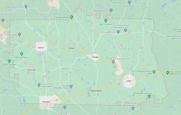
Cities and Towns in Calhoun County, Georgia
Founded in 1854, Calhoun County is one of 159 counties in the state of Georgia. Historically, Calhoun County was formed from Early and Baker counties. The city of Morgan is the county seat. With FIPS code of 37, Calhoun County has a population of 5,509 and area of 280 square miles (725 km²).
List of all cities in Calhoun County, GA alphabetically
City/Town | Postal Code | Area Code |
Arlington, GA | 39813 | 229 |
Edison, GA | 39846 | 229 |
Leary, GA | 39862 | 229 |
Morgan, GA | 39866 | 229 |
5 Major Cities and Towns in Calhoun County, Georgia
Edison
Area, Population, Zip Codes, Latitude, and Longitude
- Area: 1.4 square miles
- Population: 1,494
- Zip Codes: 39846
- Latitude: 31.4697
- Longitude: -84.5452
Location and History
Edison is located in the southeastern part of Calhoun County, positioned along U.S. Highway 41. Founded in 1889, Edison developed as a small agricultural town with a strong focus on farming and local trade. Named after the inventor Thomas Edison, the town has a history shaped by its agricultural roots and its role as a regional center for trade and services. Over the years, Edison has preserved its historical charm while adapting to modern changes, contributing to its character as a quaint and community-focused town.
Major Schools and Landmarks
Edison is served by the Calhoun County School District, including schools such as Edison Elementary School. Key landmarks in Edison include the historic Calhoun County Courthouse, a testament to the town’s administrative and historical significance. The town’s historical district features several early 20th-century buildings and homes that reflect its past. Edison’s local landmarks, combined with its close-knit community, contribute to its distinctive small-town charm and historical appeal.
Leary
Area, Population, Zip Codes, Latitude, and Longitude
- Area: 0.5 square miles
- Population: 393
- Zip Codes: 39862
- Latitude: 31.2196
- Longitude: -84.4852
Location and History
Leary is located in the northern part of Calhoun County, near the intersection of State Route 62 and State Route 37. Established in 1884, Leary has a rich history influenced by its agricultural surroundings and its role as a local trade center. Named after an early settler, the town has maintained its historical roots through its preserved architecture and historical sites. Leary’s growth has been closely tied to the agricultural economy and the development of local industries.
Major Schools and Landmarks
Leary is part of the Calhoun County School District, which includes Leary School. The town’s notable landmarks include the Leary Town Hall and several historical buildings that offer a glimpse into its past. Leary’s compact size and historical architecture contribute to its quaint and historic character. These landmarks reflect the town’s historical significance and its role in the local community, providing a sense of continuity and connection to its past.
Morgan
Area, Population, Zip Codes, Latitude, and Longitude
- Area: 0.6 square miles
- Population: 308
- Zip Codes: 39866
- Latitude: 31.4002
- Longitude: -84.4586
Location and History
Morgan is situated in the western part of Calhoun County along State Route 45. Founded in the late 19th century, Morgan emerged as a small agricultural town with a focus on farming and local commerce. The town’s history is characterized by its development in the context of the agricultural economy and its role as a local service center. Morgan has preserved its historical character through various heritage sites and buildings that reflect its past and development over time.
Major Schools and Landmarks
Morgan is served by the Calhoun County School District, including Morgan Elementary School. Key landmarks include the Morgan City Hall and several early 20th-century buildings that contribute to the town’s historic ambiance. The town’s historical sites offer insight into its past and add to its charm as a small, rural community. These landmarks highlight Morgan’s historical significance and its role in the broader context of Calhoun County’s development.
Calhoun
Area, Population, Zip Codes, Latitude, and Longitude
- Area: 5.0 square miles
- Population: 1,365
- Zip Codes: 30701
- Latitude: 34.5026
- Longitude: -84.9518
Location and History
Calhoun, located in the northeastern part of Georgia, is the county seat of Gordon County but is sometimes associated with Calhoun County due to its historical ties. Established in 1852, Calhoun has a history rich with Civil War significance and early 20th-century development. Named after John C. Calhoun, the city has evolved from a small settlement into a regional center for commerce and industry. Its historical sites and preserved buildings reflect its important role in Georgia’s history.
Major Schools and Landmarks
Calhoun hosts several significant educational institutions, including Calhoun High School and Calhoun Elementary School. Major landmarks in the city include the historic Calhoun Depot and the Gordon County Courthouse, both of which highlight the city’s historical importance and architectural heritage. The city’s historical district features well-preserved buildings that showcase its growth and development over the years. These landmarks contribute to Calhoun’s reputation as a historically rich and culturally significant city.