Where is Togo Located?
Where is Togo located on the map? Togo is an independent nation located in Western Africa. Check out the following images to see location of Togo on maps.
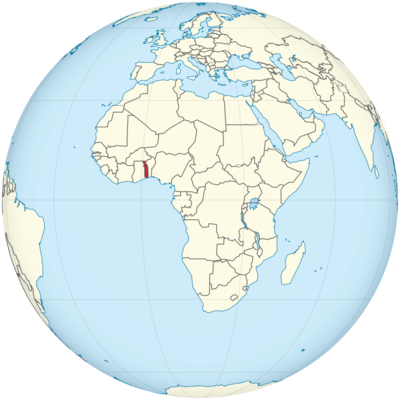
Togo Location in World Map
On the map you can see where Togo is: Togo is in West Africa.
Location Information of Togo
Togo is a small, narrow country located in West Africa. It is bordered by Ghana to the west, Benin to the east, and Burkina Faso to the north, with a coastline along the Gulf of Guinea in the south. Known for its diverse culture, rich history, and vibrant landscapes, Togo is a country of significant geopolitical importance in the region.
Latitude and Longitude
Togo lies between 6° and 11° North latitude and 0° and 2° East longitude. The country’s narrow geography stretches from the Gulf of Guinea in the south to the savannah regions in the north. This position places Togo in the tropical belt, influencing its climate and vegetation.
Capital City and Major Cities
Capital City: Lomé
The capital of Togo is Lomé, situated on the southern coast along the Gulf of Guinea. It is the largest city in the country, with a population of around 800,000 people, and serves as the political, economic, and cultural center of Togo. Lomé lies at 6.1375° N, 1.2123° E and is a major port city, facilitating Togo’s international trade.
Key features of Lomé include:
- Lomé Grand Market: A bustling, vibrant market where visitors can find everything from traditional fabrics to local produce, crafts, and spices. It is an iconic spot for experiencing the culture of Togo.
- Independence Monument: A significant landmark in the city, commemorating Togo’s independence from France in 1960.
- Togo National Museum: Located in Lomé, the museum houses a wide collection of artifacts that highlight the country’s rich cultural heritage and history.
Major Cities
- Sokodé: Located in the north of Togo, Sokodé is the second-largest city and an important cultural and administrative hub. The city has a population of approximately 100,000 people and is situated at 9.2000° N, 0.8833° E. Sokodé is known for its temples, mosques, and traditional festivals that celebrate the culture of the Tem people, the dominant ethnic group in the area.
- Kara: Situated in the northern part of the country, Kara is a city with a population of about 75,000. It is an economic and agricultural center, surrounded by the natural beauty of the Atakora mountains. Kara lies at 9.5470° N, 1.1894° E and serves as an important point for trade and commerce.
- Tchamba: A smaller but significant town located in central Togo, Tchamba is known for its agriculture and is a key part of the country’s rural economy. It is located near 7.6250° N, 1.5000° E.
- Atakpamé: Atakpamé is a city situated in the Plateau Region of Togo. The city has a population of around 60,000 and serves as a commercial and administrative center. The coordinates are 7.4585° N, 0.8322° E.
Time Zone
Togo follows the Greenwich Mean Time (GMT) zone, which is UTC +0:00. The country does not observe Daylight Saving Time (DST), meaning the time remains constant throughout the year.
- Time difference with New York City: Togo is 5 hours ahead of New York City during Standard Time (EST), and 4 hours ahead during Daylight Saving Time (EDT).
- Time difference with Los Angeles: Togo is 8 hours ahead of Los Angeles during Standard Time (PST) and 7 hours ahead during Daylight Saving Time (PDT).
Climate
Togo has a tropical climate, characterized by distinct wet and dry seasons. Due to its geographical position and its proximity to the Gulf of Guinea, Togo experiences relatively consistent temperatures, but there are variations based on altitude and proximity to the coast.
- Wet Season: The wet season lasts from April to October, with the heaviest rainfall occurring between May and August. The southern region, particularly around Lomé, receives more rainfall due to its coastal location, with annual precipitation of up to 1,200 mm (47 inches). The northern regions are less affected by rainfall but still experience some wet conditions. Average temperatures during this period range between 25°C to 30°C (77°F to 86°F).
- Dry Season: The dry season runs from November to March, with harmattan winds blowing from the Sahara Desert affecting the northern parts of the country. During this season, the weather is hot and humid, with temperatures reaching around 30°C to 35°C (86°F to 95°F). Humidity tends to be lower in the north, while the south remains more humid and relatively cooler.
- Humidity: The coastal region, especially around Lomé, experiences high humidity year-round, especially during the wet season, while the northern regions have lower humidity due to their proximity to the dry desert winds.
Economic Status
Togo is a low-income country with a developing economy. Its economy is largely driven by agriculture, with cotton, coffee, cocoa, and tropical fruits being the main exports. Togo also has a significant mining industry and is a key exporter of phosphates. Despite its challenges, such as political instability and infrastructure limitations, Togo is making efforts to modernize its economy and diversify into sectors like tourism, services, and manufacturing.
Key Sectors of the Economy:
- Agriculture: The agricultural sector is crucial, employing a significant portion of the population. Cotton is one of the country’s largest cash crops, while cocoa and coffee are also important exports. Other crops such as cassava, maize, and yams are grown mainly for domestic consumption.
- Mining: Togo is one of the largest exporters of phosphates in Africa, and the mining sector is a major contributor to the country’s foreign exchange earnings. Other mineral resources include gold and limestone.
- Services and Industry: While Togo’s industrial sector is still developing, it is gradually diversifying. The port of Lomé serves as a key regional trade hub, handling goods and services for many landlocked countries in West Africa. The manufacturing sector in Togo is focused on cement, food processing, and textiles.
- Tourism: The tourism industry is an emerging sector, though it still represents a small portion of the country’s GDP. Togo’s attractions include its beaches, natural reserves, cultural landmarks, and festivals. Despite challenges, the government is working to boost tourism as a key source of income and employment.
Tourist Attractions
Togo is a country with diverse landscapes, rich culture, and fascinating history. It offers numerous attractions for visitors, ranging from natural wonders to cultural experiences.
1. Lomé Beach
The beaches in and around Lomé are known for their golden sands and mild waves, making them ideal for relaxing, swimming, and beach activities. The coastal areas are also home to various beachfront resorts that cater to both local and international visitors.
2. The Togo National Museum
Located in Lomé, the Togo National Museum provides an excellent insight into the country’s cultural heritage, displaying collections of traditional art, crafts, and historical artifacts. Visitors can learn about Togo’s ethnic diversity, colonial history, and the significance of various regions and peoples.
3. Lake Togo
Located to the east of Lomé, Lake Togo is an inland lake that provides opportunities for boating, fishing, and birdwatching. The lake is surrounded by picturesque villages and offers a tranquil environment for nature lovers.
4. Kara Waterfalls
Situated in the northern region of Togo, Kara Waterfalls are an outstanding natural feature. The waterfalls are set in a mountainous area and are a great place for eco-tourism, hiking, and photography. The region is also home to the Tem people, whose traditional villages are known for their unique architectural styles.
5. The Tamberma Valley
A UNESCO World Heritage site, the Tamberma Valley is known for its impressive Tamberma houses, built into the cliffs of the valley. The houses are constructed using mud and straw, and the valley is a cultural and historical center for the Tamberma people.
6. Togo’s Traditional Festivals
Togo hosts several vibrant festivals throughout the year. One of the most notable is the Evala Festival in Kara, a celebration of the Kabyé people’s culture, featuring traditional dances, music, and the famous wrestling contest. The festival is a symbol of Togo’s cultural identity and draws visitors from across West Africa.
Visa Requirements for U.S. Citizens
U.S. citizens planning to visit Togo for tourism or business purposes must obtain a visa. A visa can be obtained in advance from a Togo embassy or consulate, or it may be possible to get a visa on arrival at the Lomé-Tokoin International Airport. For a tourist visa, the stay is typically limited to 7 days to 90 days.
- Visa application requirements include a valid passport (with at least six months validity), a completed visa application form, a passport-sized photograph, proof of onward travel, and proof of sufficient funds for the stay. The fee for the visa varies depending on the type and duration of stay.
Distance to New York City and Los Angeles
- Distance from Lomé to New York City: Approximately 7,800 km (4,847 miles), with a flight time of about 11 to 12 hours with one layover.
- Distance from Lomé to Los Angeles: Approximately 11,300 km (7,027 miles), with a flight time of around 14 to 15 hours, typically involving one or two layovers.
Togo Facts
| Size | 56,785 km² |
| Residents | 7.88 million |
| Languages | French, Kabiyé, Ewe |
| Capital | Lomé |
| Longest river | Mono (467 km) |
| Highest mountain | Mont Agou (986 m) |
| Currency | CFA Franc (Franc of the Financière d’Afrique Community) |


