Nicaragua Facts
Nicaragua, State of Central America; 130 700 km², 6.5 million residents (2019).Nicaragua is Central America’s largest country and borders in the north to Honduras and in the south to Costa Rica and has coast to the Caribbean in the east and the Pacific in the west. The eastern half of Nicaragua, called the Atlantic Coast, has since 1990 limited self-government. The capital is Managua (1 million residents, 2018).

Country facts
- Republic of Nicaragua / Republic of Nicaragua
- Country abbreviation: NI
- Area: 130 700 km²
- Population (2019): 6.5 million residents
- Capital: Managua
- Main language: Spanish
- State: Republic
- Head of State and Head of Government: Daniel Ortega (President)
- Per capita GDP (2018): US $ 2,029
- GNI per capita (2018): USD 2,030
- Currency unit: 1 córdoba = 100 centavos
- Currency code: NIC
- Country number (telephony): 505
- Internet domain name: ni
- Time difference compared to Sweden: −7
- National Day: September 15 (Independence Day, 1821)
Nature
- Land use: forest (27%), agricultural land (15%), other (58%)
- Highest mountain: Mogotón (2,103 m asl)
- Largest lake: Lake Nicaragua (8,430 km² )
Population
- Population density (2019): 50 residents per km²
- Natural population growth (2019): 1.6%; birth number 21 ‰, death number 5 ‰
- Age structure (2019): 0-14 years (31%), 15-64 (64%), 65- (5%)
- Life expectancy (2019): men 71 years, women 78 years
- Infant mortality (2019): 17 per 1,000 live births
- Population forecast 2050: 8 million residents
- HDI (2017): 0.658 (place 124 of 189)
- Urbanization rate (2018): 59%
- Most populous city (2018): Managua (1 million residents)
Business
- Industry’s contribution to GDP (2017): agriculture (16%), industry (24%), service (60%)
- Exports (2017): US $ 3,819 million
- Main export products: coffee, meat, gold
- Main exporting countries: USA, El Salvador, Venezuela
- Imports (2017): US $ 6,613 million
- Main import products: consumer goods, machinery, oil products
- Main importing countries: USA, China, Mexico
- Railway network: nothing in use
Geography of Nicaragua
Location
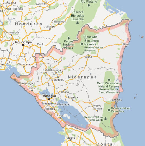
Nicaragua is located in Central America, bordered by Honduras to the north, Costa Rica to the south, the Pacific Ocean to the west, and the Caribbean Sea to the east. It is the largest country in Central America by land area, covering approximately 130,375 square kilometers (50,338 square miles). Its central position between the two oceans gives it a strategic location for trade and commerce. Nicaragua lies within the tropical zone, which influences its climate and natural features.
Topography
Nicaragua’s geography is varied, with mountains, volcanoes, rainforests, and extensive coastlines. The central region of the country is dominated by mountain ranges, such as the Cordillera de los Maribios, which runs parallel to the Pacific coast. These mountains are part of the larger Central American Volcanic Arc, and Nicaragua is home to many active volcanoes, including Mount San Cristóbal and Masaya Volcano. To the east of the mountains, the country transitions into lower plains and fertile valleys. The country’s natural beauty includes vast lakes and rivers, with Lake Cocibolca, also known as Lake Nicaragua, being the largest lake in Central America and one of the largest freshwater lakes in the world.
Rivers and Water Bodies
Nicaragua has an abundance of rivers, which have historically been important for transportation and agriculture. In addition to Lake Cocibolca, the Rio San Juan, which flows into the Caribbean Sea, is one of the most significant rivers in the country. The Rio Coco, which forms part of the northern border with Honduras, is another important waterway. These rivers are vital for local ecosystems, agriculture, and the fishing industry, as well as for hydroelectric power generation.
Coastlines and Natural Resources
Nicaragua has extensive coastlines along both the Pacific Ocean and the Caribbean Sea, providing a rich marine environment. The Pacific coast features sandy beaches, cliffs, and offshore islands, while the Caribbean coast is characterized by mangrove swamps and coral reefs. Nicaragua is endowed with various natural resources, including fertile soil for agriculture, abundant timber, and mineral deposits. The country is also known for its biodiversity, with tropical forests rich in wildlife such as jaguars, monkeys, and diverse bird species.
Climate of Nicaragua
Tropical Climate
Nicaragua experiences a tropical climate with distinct wet and dry seasons. The country’s diverse topography means that its climate can vary significantly between regions, especially when considering the difference between the coastal areas and the highlands. The western region, including cities like Managua, Leon, and Granada, has a tropical savanna climate with distinct wet and dry periods. The dry season runs from November to April, with the wet season lasting from May to October. During the rainy season, the country receives heavy rainfall, particularly from June to September, which can lead to flooding in some regions.
Caribbean Versus Pacific Climate
The Caribbean coast of Nicaragua has a more humid, tropical rainforest climate, with a more consistent rainfall pattern throughout the year. This region has higher humidity and receives significant precipitation, particularly in the form of daily showers. The Pacific region, by contrast, experiences a pronounced dry season with less rainfall overall, making it more suitable for agriculture in certain areas, such as coffee and sugarcane plantations. The climate of the highlands, including cities like Matagalpa and Jinotega, is milder, with cooler temperatures due to their higher elevation.
Vulnerability to Natural Disasters
Nicaragua is located in a region susceptible to natural disasters, particularly hurricanes, volcanic eruptions, and earthquakes. The country has experienced several devastating hurricanes, especially along its Caribbean coastline. Additionally, the presence of active volcanoes makes it prone to volcanic eruptions, which can pose a significant threat to nearby communities. Earthquakes are also a potential hazard due to Nicaragua’s position along the tectonic boundary between the North American and Pacific plates.
People of Nicaragua
Population
Nicaragua has a population of approximately 6.7 million people, making it the second-most populous country in Central America after Guatemala. The population is growing, but it remains relatively young, with a significant proportion of the population under the age of 30. The country’s population density is uneven, with the majority of people living in the western region, particularly around the capital, Managua. The eastern part of the country, which includes the Caribbean coast, is more sparsely populated.
Ethnic Groups
Nicaragua is a multicultural country with a diverse mix of ethnic groups. The majority of Nicaraguans are of mestizo (mixed indigenous and European) descent, making up about 69% of the population. There are also substantial communities of indigenous peoples, including the Miskito, Sumos, and Rama, who primarily inhabit the country’s Caribbean region. Afro-descendants, particularly along the Caribbean coast, contribute to the cultural diversity of the country. Smaller populations of people with European, Asian, and Middle Eastern origins also live in Nicaragua.
Languages
The official language of Nicaragua is Spanish, which is spoken by the vast majority of the population. In addition to Spanish, several indigenous languages are spoken, including Miskito, Sumo, and Rama, particularly in the eastern regions. English-based Creole is also spoken along the Caribbean coast, reflecting the influence of British colonialism in the region. There are also small communities of people who speak languages from other cultures, such as Chinese and Arabic.
Religion
The predominant religion in Nicaragua is Roman Catholicism, which is practiced by the majority of the population. Catholicism has played a significant role in shaping the country’s cultural and social traditions. Protestantism is also widespread, particularly in the form of evangelical Protestant denominations. Religious practice is important in many Nicaraguan communities, with religious festivals such as Easter and the feast days of various saints being celebrated with enthusiasm. Indigenous religious practices and beliefs continue to be important among indigenous communities, particularly on the Caribbean coast.
Economy of Nicaragua
Agriculture
Agriculture is a critical sector of Nicaragua’s economy, accounting for a significant portion of the country’s GDP and employing a large share of the population. Key agricultural exports include coffee, bananas, sugar, and tobacco. Coffee, in particular, is one of the country’s most valuable export commodities, with Nicaragua being one of the leading coffee producers in Central America. The country also produces a range of other crops such as maize, beans, rice, and vegetables, which are important for domestic consumption. Despite the country’s agricultural potential, the sector faces challenges, such as climate change, land degradation, and limited access to modern technology.
Manufacturing and Industry
Nicaragua’s industrial sector is smaller than its agricultural sector but is growing steadily. Key industries include food processing, textiles, cement production, and light manufacturing. The country has attracted foreign investment in textiles and apparel manufacturing, thanks to trade agreements such as the Central America-Dominican Republic Free Trade Agreement (CAFTA-DR). Additionally, Nicaragua has some mineral resources, including gold, which has become an important part of the country’s mining sector. However, despite the country’s potential, industrial development is hindered by infrastructure limitations and the need for investment in human capital and technology.
Services and Tourism
The services sector in Nicaragua is expanding, driven by retail, telecommunications, and financial services. Tourism is also a growing industry, although it remains underdeveloped compared to other Central American countries. Nicaragua offers rich cultural experiences, colonial architecture, and natural attractions, such as volcanic landscapes, lakes, and beaches. The country’s tourism industry is mostly concentrated in cities like Granada, León, and Managua, as well as along the Pacific coast, which is known for its surf spots and eco-tourism opportunities.
Economic Challenges
Despite its natural resources and potential for economic growth, Nicaragua faces significant economic challenges. Poverty remains widespread, especially in rural areas, where many people depend on subsistence farming. Income inequality is also a concern, as the benefits of economic growth have not been evenly distributed. Nicaragua is heavily reliant on external aid, remittances from the Nicaraguan diaspora, and foreign investment to support its economy. Moreover, the country faces substantial infrastructure challenges, limited access to healthcare and education, and a volatile political climate that can hinder development.
Government of Nicaragua
Political Structure
Nicaragua is a presidential republic, where the president is both the head of state and the head of government. The political system is defined by a constitution, which provides for a separation of powers among the executive, legislative, and judicial branches. The president is elected by popular vote for a five-year term, with the possibility of re-election. Nicaragua’s government operates under a multi-party system, but in recent years, the political landscape has been dominated by the Sandinista National Liberation Front (FSLN) party.
Executive Branch
The president of Nicaragua holds significant power, overseeing the government and setting policy. The president is responsible for appointing ministers, directing foreign relations, and ensuring the implementation of laws passed by the legislature. The president also serves as the commander-in-chief of the armed forces. In recent years, the executive branch has come under criticism for concentrating power, particularly in the hands of President Daniel Ortega and his administration, leading to concerns about democratic backsliding and authoritarianism.
Legislative Branch
Nicaragua’s legislative body is the National Assembly, a unicameral body made up of 92 deputies. Deputies are elected for five-year terms, and the National Assembly is responsible for passing laws, approving the national budget, and overseeing the actions of the executive branch. The National Assembly also plays a critical role in approving appointments made by the president, such as those to the judiciary. Despite its formal powers, the legislative branch has often been seen as lacking independence due to the dominance of the executive.
Judiciary
The judicial branch in Nicaragua is intended to be independent, with the Supreme Court serving as the highest judicial authority. The judiciary is responsible for interpreting laws, handling criminal and civil cases, and ensuring justice is served. However, in recent years, concerns have arisen regarding the independence of the judiciary, as many of the country’s judges have been appointed by the executive branch, leading to accusations of political interference and a lack of judicial impartiality.
Culture of Nicaragua
Traditional Culture
Nicaraguan culture is influenced by a mix of indigenous, Spanish, and African traditions. The indigenous peoples of Nicaragua, particularly in the north and east, have maintained many of their traditional practices, including the use of indigenous languages and customs related to agriculture, art, and spirituality. Spanish colonization brought Catholicism, European customs, and architectural styles, which are reflected in the country’s cities and towns. African influence, particularly from the Afro-descendant communities on the Caribbean coast, has shaped music, dance, and cuisine.
Music and Dance
Music and dance are central to Nicaraguan culture, with many forms of folk music reflecting the country’s diverse heritage. The marimba, a traditional wooden percussion instrument, is one of the most iconic instruments in Nicaraguan music, and the rhythms of cumbia, salsa, and son are commonly heard at festivals and celebrations. Dance is also an important part of social life, with traditional dances like the “Palo de Mayo” and “La Cumbia” being performed during holidays and festivals.
Festivals and Celebrations
Nicaragua has a vibrant calendar of festivals and holidays, many of which celebrate the country’s cultural and religious heritage. Major celebrations include the feast of Saint Sebastian, the Nicaraguan Independence Day on September 15, and the “Fiestas Patronales,” which are dedicated to various saints and take place in different regions of the country. These festivals often feature music, dance, processions, and traditional foods, creating a lively atmosphere that brings communities together.
Cuisine
Nicaraguan cuisine is influenced by its indigenous, Spanish, and African roots, resulting in a diverse and flavorful culinary tradition. The diet of many Nicaraguans includes staple foods such as rice, beans, and corn, often accompanied by meat, such as chicken, beef, or pork. Traditional dishes include “gallo pinto” (a rice and beans dish), “quesillo” (a type of cheese served with tortillas), and “vigorón” (a dish made with pork, cabbage, and yuca). Seafood, particularly on the Caribbean coast, is also an important part of the Nicaraguan diet.
History of Nicaragua
Pre-Columbian and Colonial Era
The history of Nicaragua dates back to pre-Columbian times when the region was inhabited by indigenous peoples such as the Nahua, Chorotega, and Miskito. These groups lived in a mix of settled agricultural communities and more nomadic groups. The arrival of Spanish explorers in the 16th century led to the colonization of Nicaragua, which became part of the Spanish Empire. During this period, the indigenous population was decimated through violence, disease, and forced labor.
Independence and Early National History
Nicaragua gained independence from Spain in 1821, becoming part of the United Provinces of Central America, a federation that included several Central American countries. In 1838, Nicaragua declared its full independence and became a sovereign republic. The early years of the country’s independence were marked by political instability, with frequent struggles between liberals and conservatives, leading to civil wars and foreign intervention, including a brief period of occupation by the United States.
20th Century and the Sandinista Revolution
The 20th century saw continued political turmoil in Nicaragua, with periods of dictatorship and revolution. In 1979, the Sandinista National Liberation Front, a socialist revolutionary group, overthrew the Somoza dictatorship that had ruled the country for several decades. The Sandinistas, led by Daniel Ortega, introduced sweeping social reforms, but their government also faced opposition from U.S.-backed Contra rebels. The country was engulfed in a civil war throughout the 1980s, which devastated the economy and left a lasting political divide.
Recent History
After the end of the civil war in the late 1980s, Nicaragua underwent a period of political and economic restructuring. In 1990, Daniel Ortega lost the presidency to Violeta Chamorro in democratic elections, but he returned to power in 2007. Since then, Ortega has maintained a significant role in the country’s politics, although his government has been criticized for its authoritarian tendencies, suppression of opposition, and restrictions on civil liberties. Despite these challenges, Nicaragua remains an important country in Central America, with a rich cultural heritage and a growing economy.
Nicaragua Map