Mongolia Facts
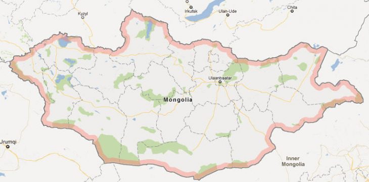
Mongolia, a state in inner Asia between the Russian Federation in the north and China in the south; 1.6 million km², 3.2 million residents (2019).Mongolia was formerly sometimes called Outer Mongolia (unlike Inner Mongolia, an autonomous region of northern China). Administratively, Mongolia consists of three urban areas and 18 provinces. The capital is Ulaanbaatar (1.4 million residents, 2019).
Country facts
- Boggd Najramdach Mongol Ard Uls / Mongolia
- Country abbreviation: MN
- Area: 1.6 million km²
- Population (2019): 3.2 million residents
- Capital: Ulaanbaatar
- Main language: Mongolian
- State: Republic
- Head of State: Chaltmaagijn Battulga (President)
- Head of Government: Uchnaagijn Chürelsüch
- Per capita GDP (2018): US $ 4,104
- GNI per capita (2018): US $ 3,580
- Coin unit: 1 tea tree = 100 polygon
- Currency code: MNT
- Country Dialing (Telephony): 976
- Internet domain name: mn
- Time difference compared to Sweden: +7 to +9
- National Day: July 11 (Independence Day, 1921)
Nature
- Land use: forest (8%), agricultural land (1%), pasture land (75%), other (16%)
- Highest mountain: Youyi Feng (4,374 m asl)
Population
- Population density (2019): 2 residents per km²
- Natural population growth (2019): 1.9%; birthrate 25 ‰, deathrate 6 ‰
- Age structure (2019): 0-14 years (31%), 15-64 (65%), 65- (4%)
- Life expectancy (2019): men 66 years, women 76 years
- Infant mortality (2019): 13 per 1,000 live births
- Population forecast 2050: 4 million residents
- HDI (2017): 0.741 (place 92 of 189)
- Urbanization rate (2019): 68%
- Most populous cities (2019): Ulaanbaatar (1.4 million residents), Erdenet (99,500), Darchan (84,700)
Business
- Industry’s contribution to GDP (2017): agriculture (12%), industry (38%), service (50%)
- Exports (2017): US $ 5,834 million
- Main export products: minerals, housing, clothing
- Main exporting countries: China, United Kingdom
- Imports (2017): US $ 4 345 million
- Main import products: machinery, fuel, means of transport
- Main importing countries: China, Russian Federation, Japan
- Railway network (2017): 1 800 km
Geography of Mongolia
Location and Boundaries
Mongolia is a landlocked country located in Central Asia, bordered by Russia to the north and China to the south. It covers an area of about 1.56 million square kilometers, making it the 18th largest country in the world. The country’s strategic position in Asia has made it a historical crossroads for several nomadic civilizations, and its vast, open spaces and rugged terrain define much of its identity.
Mongolia lies between latitudes 41° and 52° N and longitudes 87° and 120° E. It shares a relatively long land border with Russia to the north (around 3,485 kilometers) and a shorter, more porous border with China to the south (about 4,677 kilometers). These boundaries have shaped Mongolia’s geopolitical relations and its development throughout history.
Terrain and Landscape
The landscape of Mongolia is diverse, encompassing vast steppes, desert, and mountainous regions. The Mongolian Plateau is a large elevated area that forms much of the country, and it is surrounded by mountain ranges that include the Altai Mountains in the west and the Khentii Mountains in the northeast. The country’s topography ranges from flat grasslands to rugged hills and mountains, contributing to its widely varying climates and ecosystems.
The Gobi Desert, located in the southern part of Mongolia, is one of the largest deserts in Asia and one of the most famous geographical features of the country. This desert is known for its stark beauty, sand dunes, and extreme temperature fluctuations. In contrast, Mongolia’s northern regions are characterized by dense forests and wetlands, providing rich habitats for various species of wildlife.
Rivers and Lakes
Mongolia is home to several important rivers, although many are short and seasonal. The major rivers include the Selenge River, which flows north into Lake Baikal in Russia, and the Onon River, which is significant in the eastern part of the country. The Lake Khövsgöl, located in the northwestern region, is one of the largest and most important freshwater lakes in Mongolia. It is known for its crystal-clear waters and is a key feature of the Mongolian landscape, often referred to as the “Blue Pearl” of the country.
Despite being landlocked, Mongolia’s rivers and lakes play vital roles in the local agriculture, providing essential irrigation and supporting local fishing industries. These water bodies, along with underground springs, are crucial for sustaining life in Mongolia’s otherwise arid regions.
Climate of Mongolia
Continental Climate
Mongolia is characterized by a continental climate, with extremely cold winters and warm to hot summers. The country experiences some of the most extreme temperature fluctuations in the world, with temperature differences of up to 100°C between the summer and winter months. This climate has been shaped by Mongolia’s inland location and its altitude, with most of the country situated more than 1,000 meters above sea level.
Winters in Mongolia are harsh, especially in the northern and central parts, with temperatures regularly dipping below -40°C (-40°F) during the coldest months of December and January. These cold temperatures are exacerbated by strong winds, which can make conditions even more severe. Winters are long, typically lasting from November to March, with snowfall accumulating in many regions.
In contrast, the summers in Mongolia can be quite warm, particularly in the southern and central steppes. Daytime temperatures can reach 30°C to 35°C (86°F to 95°F) during the peak summer months of June and July. These temperature extremes between summer and winter are one of the most defining features of Mongolia’s climate.
Seasonal Precipitation
Mongolia receives relatively little precipitation throughout the year, with the majority of rainfall occurring in the summer months, from June to September. The precipitation is concentrated in the form of short, intense thunderstorms, especially in the central and northern parts of the country. The southern Gobi Desert receives the least rainfall, averaging just 100-200 millimeters (4-8 inches) annually.
The dry conditions and sparse rainfall contribute to Mongolia’s vulnerability to droughts, which can severely impact agriculture and grazing, the main sources of livelihood for the population. The lack of consistent rainfall and the shifting seasonal weather patterns make the country’s climate particularly challenging for agriculture and human habitation.
Winds and Environmental Hazards
Mongolia experiences significant wind activity, especially during the spring and winter months. The harsh winter winds can bring chilling conditions and are responsible for significant wind chill factors. Dust storms are also a common occurrence, particularly in the Gobi Desert, where high winds blow sand and dust across the landscape, limiting visibility and affecting air quality. These winds are integral to the Mongolian climate and contribute to the region’s extreme conditions.
People of Mongolia
Population and Demographics
Mongolia has a population of about 3.3 million people, making it one of the least densely populated countries in the world. The majority of the population resides in urban areas, particularly in the capital city, Ulaanbaatar, which is home to around 45% of the country’s population. Ulaanbaatar serves as the political, economic, and cultural center of Mongolia, and its urbanization has been growing rapidly in recent decades.
Mongolia’s population is relatively young, with a median age of about 28 years. Despite a high rate of urbanization, a significant portion of the population still lives in rural areas and maintains a traditional nomadic lifestyle. Nomadic herding, primarily of sheep, goats, cattle, and camels, continues to be a vital part of Mongolia’s cultural identity and economy.
Ethnicity and Languages
The majority of the population in Mongolia is of Mongol ethnicity, with the rest of the population being made up of various ethnic minorities, including Kazakhs, Russians, and smaller groups such as the Tuvans and Buryats. The Mongol people have a rich cultural heritage that is deeply intertwined with their history as a nomadic people and their association with the Mongol Empire.
The official language of Mongolia is Mongolian, which belongs to the Mongolic language family. The Mongolian Cyrillic alphabet, adopted during the Soviet era, is the primary writing system used in the country. However, many Mongols also speak Kazakh, Russian, and English, particularly in urban areas and among younger generations. Despite the influence of Russian and English, the preservation of the Mongolian language is a key part of the country’s cultural identity.
Religion and Beliefs
Mongolia is primarily a Buddhist country, with Tibetan Buddhism being the dominant religion. Buddhism was introduced to Mongolia in the 16th century and became the state religion. Monasteries and Buddhist practices are an integral part of Mongolian culture, and rituals such as the celebration of Tsagaan Sar (Lunar New Year) and the annual Naadam Festival are often infused with Buddhist customs.
Shamanism, which involves the worship of spirits and the natural world, is also practiced, especially among rural and nomadic communities. While Buddhism is the dominant religion, many Mongolians incorporate elements of shamanism and animism into their daily lives, reflecting the country’s long-standing reverence for nature and its spiritual practices.
Islam is practiced by a small minority of the population, particularly among the ethnic Kazakh community in the western part of Mongolia. Christianity, especially Russian Orthodox Christianity, is also practiced by a small segment of the population.
Economy of Mongolia
Economic Overview
Mongolia has a mixed economy, with a significant reliance on mining, agriculture, and animal husbandry. The country is rich in natural resources, and mining, particularly coal, copper, and gold, is the cornerstone of Mongolia’s economy. However, Mongolia remains one of the world’s poorest countries, despite its mineral wealth, due to factors such as political instability, geographic isolation, and a lack of infrastructure.
Mongolia’s economy has grown in recent years, especially following the market reforms of the early 1990s and the subsequent privatization of many state-owned industries. Despite challenges, Mongolia has increasingly integrated into the global economy, benefiting from foreign investment, particularly in its mining sector.
Mining and Natural Resources
Mongolia is rich in mineral resources, including coal, copper, gold, uranium, and rare earth metals. The country’s vast deposits of coal in the Tavan Tolgoi region, for example, are among the largest untapped coal reserves in the world. Mongolia’s copper mines, particularly the Oyu Tolgoi mine, are vital to the country’s economy and provide a significant portion of government revenue.
In addition to copper and coal, Mongolia also has significant gold reserves, which are extracted from several sites across the country. The mining sector has attracted considerable foreign investment, particularly from China and other countries interested in raw materials. However, the sector is highly vulnerable to fluctuations in global commodity prices, which can significantly impact Mongolia’s economy.
Agriculture and Animal Husbandry
Agriculture is another key component of Mongolia’s economy, although it is largely subsistence-based in rural areas. Nomadic herding remains a central cultural and economic practice, with livestock such as sheep, goats, cattle, and camels being raised for meat, milk, wool, and hides. Mongolia is a major exporter of cashmere, which comes from goats raised in the harsh climate of the steppes. The country is also known for its wool production and meat exports, particularly beef and mutton.
The agricultural sector, however, is highly vulnerable to climate change, particularly droughts and extreme winters known as “dzuds,” which can lead to the death of large numbers of livestock. These environmental risks make food production unstable, and the country’s reliance on agriculture is one of its most significant economic challenges.
Services and Infrastructure
The services sector in Mongolia is growing, with financial services, tourism, and telecommunications expanding in urban centers. However, infrastructure development remains limited, particularly in rural areas, where road networks and basic utilities are underdeveloped. The urbanization of the country has been rapid, with many rural residents migrating to Ulaanbaatar in search of better opportunities, placing a strain on housing, health, and education services.
Tourism is an emerging sector in Mongolia’s economy, with travelers attracted to the country’s rich cultural history, natural beauty, and outdoor activities such as hiking, horseback riding, and visiting historic sites like the ancient capital of Kharkhorin and the Gobi Desert.
Government of Mongolia
Political System and Structure
Mongolia is a democratic republic with a multi-party system. The President of Mongolia is the head of state, while the Prime Minister is the head of government. The President is elected for a four-year term, while the Prime Minister, who is appointed by the Parliament, serves as the leader of the executive branch.
The Mongolian government is based on a system of separation of powers, with the Parliament (State Great Khural) acting as the legislative body. The Parliament consists of 76 members, who are elected every four years through a mixed-member proportional representation system. The judiciary is independent, with the Constitutional Court serving as the highest authority in constitutional matters.
Electoral System and Political Parties
Mongolia’s political system has evolved significantly since the country transitioned from a one-party communist state to a multi-party democracy in the early 1990s. The two dominant political parties in Mongolia are the Mongolian People’s Party (MPP), a center-left party, and the Democratic Party, a center-right party. These parties frequently alternate in power, and coalition governments are common.
Mongolia’s electoral system is based on a combination of first-past-the-post and proportional representation, with voters electing both single-member constituency representatives and party representatives to the Parliament. Presidential elections are held every four years, and the president has limited executive powers, acting more as a ceremonial figure.
Foreign Relations and Defense
Mongolia maintains a policy of neutrality and non-alignment in international relations, but it actively participates in international organizations such as the United Nations, the World Trade Organization, and the Shanghai Cooperation Organization. Mongolia has strong ties with its neighbors, Russia and China, as well as with countries in Europe and the United States.
Mongolia’s defense policy is primarily focused on maintaining a small, well-trained military force for national defense. The country does not maintain large military capabilities but has a strategic relationship with Russia, with whom it shares a long border. Mongolia also participates in peacekeeping missions and is a member of the Partnership for Peace program with NATO.
Culture of Mongolia
Art, Music, and Literature
Mongolian culture is deeply rooted in its nomadic traditions, which have influenced its art, music, and literature. Mongolian art is traditionally characterized by vibrant colors and depictions of nature, animals, and religious themes. Painting, sculpture, and embroidery are important forms of artistic expression, and the traditional art forms are often inspired by the country’s Buddhist heritage.
Mongolian music is also distinctive, with throat singing (khöömei) being one of the most famous aspects of the country’s cultural heritage. Khöömei is a form of vocalization that produces multiple pitches simultaneously, mimicking the sounds of nature. The traditional instruments, such as the morin khuur (horsehead fiddle), are used to accompany folk songs, which often tell stories of Mongolia’s history, legends, and the vast steppe landscapes.
Festivals and Traditions
Mongolia is known for its rich array of festivals and cultural traditions. The Naadam Festival, held every July, is the most important celebration in Mongolia, commemorating the country’s independence and its traditional sports: wrestling, horse racing, and archery. These events have deep cultural and historical significance and are celebrated with vibrant ceremonies, music, and traditional clothing.
Another major tradition is Tsagaan Sar, the Mongolian Lunar New Year, which is a family-oriented celebration involving the honoring of ancestors, feasting, and the exchange of gifts. Traditional clothing, known as the deel, is worn during these celebrations, showcasing the country’s nomadic heritage.
Cuisine and Dining
Mongolian cuisine is based on the principles of meat, dairy, and grains, reflecting the country’s nomadic lifestyle. The traditional diet includes dishes such as mutton, beef, and camel meat, which are often stewed, roasted, or boiled. Dairy products like yogurt, cheese, and curd are common, and bread made from flour and barley is a staple.
The national dish is khuushuur, a fried meat-filled pastry, often served during celebrations and festivals. Other popular dishes include buuz (steamed dumplings) and airag (fermented mare’s milk). Food preparation in Mongolia is simple but hearty, designed to provide energy for a nomadic lifestyle in harsh conditions.
History of Mongolia
Early History and the Mongol Empire
Mongolia’s history is deeply entwined with its vast steppe and its legacy as the home of the Mongol Empire, the largest contiguous empire in history. The Mongols, originally a collection of nomadic tribes, were united under the leadership of Genghis Khan in the early 13th century. His conquests stretched from East Asia to Eastern Europe, and the empire he founded significantly impacted the course of world history. Under Genghis Khan and his descendants, the empire fostered trade, cultural exchange, and the spread of technology across Eurasia.
The Mongol Empire’s decline in the late 14th century led to a fragmented Mongolia, with the rise of several regional powers, including the Yuan Dynasty in China. The country’s vast territories were divided among competing rulers, and Mongolia eventually fell under the control of neighboring China.
Mongolian Rule and Russian Influence
In the 17th century, Mongolia came under the suzerainty of the Qing Dynasty of China, marking a period of relative political stability but also suppression of Mongolian culture and autonomy. The Mongols sought independence in the early 20th century, and after the Russian Revolution of 1917, Mongolia declared independence in 1911, although it was not fully recognized until 1921.
During the 20th century, Mongolia became a satellite state of the Soviet Union, adopting communism and aligning with Soviet policies. The Mongolian People’s Republic was established in 1924, and the country underwent significant social, political, and economic changes under Soviet influence.
Modern Mongolia
In 1990, after the collapse of the Soviet Union, Mongolia transitioned to a multi-party democracy and a market economy. The country’s democratic reforms, however, were not without challenges, including economic difficulties, political instability, and the need to transition from a planned economy to one based on market principles.
Today, Mongolia is a democratic republic, with a growing economy largely driven by mining and agriculture. However, it continues to face challenges, including environmental issues and dependence on trade with neighboring countries, particularly China. Despite these challenges, Mongolia’s rich cultural heritage, unique history, and resilience in adapting to modern changes continue to shape its future.
Mongolia Map